
|
Geological Survey Circular 838
Guides to Some Volcanic Terrances in Washington, Idaho, Oregon, and Northern California |
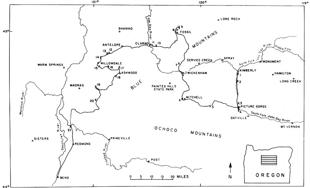
ROADLOG FOR GEOLOGIC FIELD TRIP BETWEEN KIMBERLY AND BEND, OREGON WITH EMPHASIS ON THE JOHN DAY FORMATION
Paul T. Robinson, Department of Earth Sciences, University of California, Riverside, California 92521
| MILES | |||
| Kimberly. Turn left on Highway 19 toward Dayville and John Day. | |||
| (0.35) | |||
| 0.35 | Cross North Fork of John Day River. | ||
| (0.40) | |||
| 0.75 | High level pediment at 12 o'clock. These are common along the John Day River between Kimberly and Picture Gorge. | ||
| (0.60) | |||
| 1.35 | Stop 1 (Optional). Dike of Picture Corge Basalt cuts upper buff beds of the John Day Formation, Dike strikes about N.30°W. and is essentially vertical. It has fine-grained margin and complex joint pattern. Although dike is about 10 meters wide the intruded sediments show little baking and only moderate induration. | ||
| (0.05) | |||
| 1.40 | Stream gravels in roadcut on left. | ||
| (0.55) | |||
| 1.95 | Dike crosses road at this point. | ||
| (0.75) | |||
| 2.70 | Tuffaceous claystones and tuffs of upper John Day Formation in roadcut on left. From here to Picture Gorge roadcuts are mostly in John Day rocks. | ||
| (0.45) | |||
| 3.15 | High level pediments on both sides of John Day River ahead. | ||
| (0.40) | |||
| 3.55 | Picture Gorge dike on hillside east of John Day River at 2 o'clock. | ||
| (0.60) | |||
| 4.15 | Greenish tuffs and tuffaceous claystones of John Day Formation at 3 o'clock. | ||
| (1.15) | |||
| 5.30 | Stop 2 (Optional). Green beds of John Day Formation overlying Picture Gorge Ignimbrite on left side of road. The ignimbrite here is about 10 meters thick and exhibits platy jointing near base with massive, rounded outcrops above. Ignimbrite is moderately welded with eutaxitic structure defined by elongate pumice fragments. Quartz bipyramids and feldspar crystals comprise 1-2% and lithic fragments are sparse. Altered glass chips and fragments are also present. Ignimbrite is altered and zeolitized. | ||
| (0.40) | |||
| 5.70 | Good exposures of green tuffs and tuffaceous claystones of John Day Formation at 9 o'clock. Note characteristic erosion into pinnacles. Ledge is Picture Gorge Ignimbrite. | ||
| (1.40) | |||
| 7.10 | Good exposures of green tuffs and tuffaceous claystones of John Day Formation at 9 and l1 o'clock. Ledges are slightly more resistant airfall tuffs inter layered with less resistant claystones. | ||
| (0.55) | |||
| 7.65 | Middle John Day beds at 2 to 3 o'clock with Picture Gorge Ignimbrite forming prominent ledge. The ignimbrite is partly slumped toward the river. Stream gravels in roadcut on left. | ||
| |||
| (1.50) | |||
| 9.15 | Entrance to Foree Area of John Day Fossil Beds National Monument. Middle green portion of John Day Formation with ledge of Picture Corge Ignimbrite crops out on both sides of river. Note slump blocks at 3 o'clock on west side of river. | ||
| (0.35) | |||
| 9.50 | Lower red tuffaceous claystones of John Day Formation at 9 o 'clock. | ||
| (0.85) | |||
| 10.35 | Large landslide blocks of Picture Gorge Basalt on both sides of the road. | ||
| (0.55) | |||
| 10.90 | Cathedral Rock at 1 o'clock shows ledge of Picture Gorge Ignimbrite interbedded with green tuffs and tuffaceous claystones of John Day Formation. | ||
| (1.50) | |||
| 12.40 | Ahead, dips in Picture Gorge flows define syncline plunging south (upriver). | ||
| (0.50) | |||
| 12.90 | Sheared serpentinite, presumably of Triassic age, Brown and Thayer (1966), left of road. | ||
| (0.90) | |||
| 13.80 | Entrance to Turtle Cover Area, John Day Fossil Beds National Park. Type area of Turtle Cover Member of John Day Formation. | ||
| (0.60) | |||
| 14.40 | Bridge across river. Enter Picture Gorge Basalt, brought down by plunge of syncline. | ||
| (0.50) | |||
| 14.90 | Fault, south side up, Picture Gorge Basalt. Rock 0.5 miles to the brings Cretaceous conglomerates into contact with Conglomerates exposed on both sides of road at Goose south. | ||
| (2.15) | |||
| 17.05 | Stop 3. Sheep Rock on east side of river. Complete section of John Day Formation exposed here. Red beds on left (to the north) are the Big Basin Member resting on Cretaceous conglomerates. Overlying green tuffs and tuffaceous claystones make up Turtle Cover Member, characterized by extensive alteration and zeolitization. The Picture Gorge Ignimbrite occurs in the upper part of the Turtle Cover Member. The buff to tan beds in the upper part of the formation comprise the Kimberly Member, characterized by unzeolitized tuffs and tuffaceous claystones. This is overlain by two flows of Picture Gorge Basalt. Note small normal faults offsetting Picture Gorge Ignimbrite, downdropped to the north. | ||
| (1.60) | |||
| 18.65 | Entrance to Picture Gorge. Location of type section of the basalt. The gorge is not named for the graffiti, some of it geologic in the form of painted numbers incorrectly designating the number of flows. Lowest exposed flow in roadcut on right. | ||
| (0.20) | |||
| 18.85 | Intersection with U.S. 26, Continue straight ahead through Gorge. Note many flow contacts. | ||
| (0.90) | |||
| 19.75 | Well exposed flow contact on right. | ||
| (0.45) | |||
| 20.20 | Leave gorge, with tuffaceous sedimentary rocks of Miocene Mascall Formation overlying Picture Gorge Basalt. | ||
| (1.20) | |||
| 21.40 | Turn right sharply onto Day Creek Road. Proceed 0.1 mile, turn right on
dirt track and continue for several hundred feet to overlook. Stop 4. Dip slope of Picture Gorge Basalt to the north projects beneath valley of John Day River. Picture Gorge Basalt unconformably overlain by Mascall formation with contact roughly parallel tn river. Mascall Formation unconformably overlain by Rattlesnake Formation just west nf Picture Gorge. Rattlesnake Formation consists of prominent ash-flow sheet (~6 m.y.) lying between layers of conglomerate, each several hundred feet thick. Rattlesnake unconformably overlaps Mascall Formation and rests on Picture Gorge Rasalt directly above the gorge. Return to U.S. 26 and Oregon 19. Turn left and proceed northward back through the gorge. | ||
| (2.80) | |||
| 24.20 | Junction U.S. 26 and Oregon 19. Turn left toward Mitchell and proceed up Rock Creek. Road cuts are in Picture Gorge Basalt. | ||
| (1.60) | |||
| 25.80 | Contact of Mascall Formation and Picture Gorge Basalt in road cut on left. Ledge on top of bill at left is Rattlesnake welded tuff. For about the next 2 miles Rock Creek follows contact between Picture Gorge Basalt and Mascall Formation. | ||
| (1.90) | |||
| 27.70 | Fault crosses road, downdropping Mascall beds on north side. Road traverses basalt for next 0.3 miles and then passes into overlying Mascall Formation. | ||
| (1.00) | |||
| 28.70 | Fault crosses road, downdropping Mascall beds on north side and uplifting Picture Gorge Basalt on south side. Road enters basalt again. | ||
| (0.90) | |||
| 29.60 | Picture Gorge Basalt and underlying sediments of John Day Formation. Good exposures of John Day rocks on right side of road at 3 o'clock. Road passes through poorly exposed outcrops of John Pay Formation for about 1 mile. | ||
| (0.90) | |||
| 30.50 | Small outcrop of Cretaceous conglomerate on right side of highway. | ||
| (0.40) | |||
| 30.90 | Flows and breccia of Clarno Formation exposed in roadcuts on right hand side of highway. Roadcuts continue in the Clarno Formation for approximately the next 5 miles, | ||
| (0.95) | |||
| 31.85 | Pinnacles in gully on left side of highway are composed of Clarno laharic breccia. | ||
| (0.30) | |||
| 32.15 | John Day tuffs overlie laharic breccias of Clarno Formation south of stream. John Day beds largely obscured by slump blocks of overlying Picture Gorge Basalt. | ||
| (1.75) | |||
| 33.90 | Clarno laharic breccia on right side of highway is overlain by John Day tuffaceous sediment which in turn is overlain by Picture Gorge Basalt. | ||
| (2.05) | |||
| 35.95 | Picture Gorge Basalt overlying red sediments of John Day Formation. Road cuts for next 5 miles are in Picture Gorge Basalt as road climbs through section. | ||
| (4.90) | |||
| 40.85 | Junction of Antone Road and M.S. 26. Continue straight ahead. Quarry south (left) of highway is in Picture Gorge Basalt. Ridge north of highway consists of Picture Gorge Basalt capped by Rattlesnake welded tuff. For about next 5.5 miles highway runs along top of Picture Gorge Basalt with Rattlesnake welded tuff exposed in hills on right hand side. | ||
| (0.80) | |||
| 41.65 | Tree covered ridge to south (left) is Ochoco Basalt resting on Rattlesnake Formation. | ||
| (1.00) | |||
| 4.65 | Stop 5 (Optional). Outcrop of Rattlesnake welded tuff on left. Glassy, fine-grained, moderately to densely welded tuff with a few large collapsed pumice fragments. Outcrop has well developed platy jointing. | ||
| (1.90) | |||
| 44.55 | John Day Formation in road cut with Rattlesnake welded tuff on bill to right. | ||
| (2.75) | |||
| 47.30 | Rattlesnake welded tuff caps ridge to left. This is westernmost occurrence of this member in the John Day drainage. | ||
| (0.50) | |||
| 47.90 | Highly altered Clarno andesite on right side of road. Road cuts will be in Clarno Formation for approximately the next 7 miles. | ||
| (1.15) | |||
| 49.05 | Keyes Summit. Keyes Mountain, an exhumed Oligocene volcano composed of Clarno andesite flows and breccias, can be seen at 2 o'clock. | ||
| (1.90) | |||
| 50.95 | Clarno laharic breccia with very large andesite clasts on right side of road. | ||
| (1.70) | |||
| 52.65 | Platy Clarno andesite flow in road cut on right. | ||
| (1.90) | |||
| 54.55 | Turn off for Mitchell business loop. Continue straight ahead on U.S. 26. | ||
| (0.20) | |||
| 54.75 | Contact of Clarno Formation and Cretaceous shales and conglomerates on right. | ||
| (0.25) | |||
| 55.00 | Junction Oregon 206 with U.S. 26. Continue straight ahead on M.S. 26. | ||
| (0.35) | |||
| 55.35 | Turn right on old highway. Stop 6. Examine Cretaceous sandstone and conglomerate. Continue on old highway for 0.40 miles to Oregon 206. Turn sharply left on 206 toward Service Creek and Fossil. | ||
| (0.95) | |||
| 56.30 | Contact of Clarno lava flows overlying Cretaceous rocks in roadcut on right. | ||
| (0.25) | |||
| 56.55 | Outcrop of Cretaceous sandstone, conglomerate, and shale. Clarno dike can be seen at 9 o' clock. | ||
| (0.75) | |||
| 57.30 | Roadcut in Cretaceous shales. Butte at 2 o'clock is Clarno andesite on top of Cretaceous rocks. Straight ahead on skyline is Picture Gorge Basalt of Sutton Mountain. | ||
| (2.00) | |||
| 59.30 | On left are Permian (?) metasediments. Rocks include phyllites, marbles, and blueschists. (Swanson, 1969). | ||
| (1.05) | |||
| 60.35 | Hills on left are composed of Cretaceous conglomerate and sandstone. | ||
| (4.35) | |||
| 64.70 | Clarno andesites overlie Cretaceous rocks on right side of highway. | ||
| (0.70) | |||
| 65.40 | Junction of Oregon 206 with Twickenham Road. Turn left toward Twickenham. At right is narrow hand of John Day sediments between Clarno Formation and Picture Gorge Basalt. For approximately next 7 miles the road traverses Sutton Mountain, a shallow syncline of Picture Gorge Basalt. | ||
| (2.65) | |||
| 68.05 | Hackly jointing in thick basalt flow on right. | ||
| (0.80) | |||
| 68.85 | Hackly jointing in thick basalt flow. | ||
| (3.80) | |||
| 72.65 | Twickenham Bridge across John Day River. This is on the west side of the Sutton Mountain syncline and Picture Gorge Basalt dips eastward with John Day rocks exposed beneath. Steep, cliff-forming flows at 12 o'clock and 2 o'clock are thick, hackly-jointed flows seen along road. | ||
| (1.70) | |||
| 74.35 | Hogback on right is Picture Gorge Ignimbrite interlayered with tuffs and tuffaceous claystones of John Day Formation. Numerous landslide blocks of Picture Gorge Basalt obscure the upper part of the John Day Formation. | ||
| (0.45) | |||
| 74.80 | Picture Gorge Ignimbrite exposed on right. White, resistant ledge below ignimbrite is rhyolite air-fall tuff with large soda-rich sanidine crystals believed to be equivalent of ash-flow tuff of member G of western facies of John Day Formation. | ||
| (1.05) | |||
| 75.85 | Clarno lava flows on left underlie John Day Formation. Good view on right of John Day outcrops with Picture Gorge Basalt above. | ||
| (0.90) | |||
| 76.75 | Red tuffaceous claystones in road cut on left are lower John Day beds lying just above contact with Clarno Formation. At 12 o'clock are the buff and green tuffaceous sediments of the middle John Day. | ||
| (0.85) | |||
| 77.60 | Stop 7. Walk up gully for several hundred feet to outcrop of basal ash-flow tuff of John Day Formation. The tuff is moderately welded with a well developed eutaxitic texture. It contains about 5% phenocrysts, chiefly quartz and sanidine with minor plagioclase. Based on lithology, phenocryst mineralogy, and stratigraphic position this tuff is correlated with the basal ash-flow tuff of the western facies of the John Day Formation (Swanson and Robinson, 1968; Woodburne and Robinson, 1977). | ||
| (0.35) | |||
| 77.95 | Red tuffaceous claystone of basal John Day Formation resting on platy Clarno lava flows. Road follows the contact for about the next 1.5 miles. | ||
| (1.15) | |||
| 79.10 | Basal ashflow tuff of John Day Formation is exposed at end of dam. Clarno andesite flows crop out across the reservoir, on left. | ||
| (0.40) | |||
| 79.50 | The Clarno-John Day contact rises to the right and the road enters Clarno outcrops. Road cuts will be in Clarno Formation from here to town of Fossil. | ||
| (1.25) | |||
| 80.75 | High peak at 9 o'clock is Clarno mafic intrusion. | ||
| (0.40) | |||
| 81.15 | Red claystones and laharic breccias on left are interlayered with Clarno an desite flows. | ||
| (2.35) | |||
| 83.50 | High peak at 12 o'clock is Rancherie Rock. This is a porphyritic hornblende andesite plug in Clarno Formation. | ||
| (4.40) | |||
| 87.90 | Junction with Oregon Highway 19. Turn left toward Fossil. | ||
| (0.75) | |||
| 88.65 | Butte Creek Summit. Good outcrops of Clarno andesite on both sides of highway. | ||
| (5.60) | |||
| 94.25 | Kinzua road junction. Continue straight ahead toward Fossil. | ||
| (2.60) | |||
| 96.85 | Tuffaceous claystones of Clarno Formation, in road cut on right. | ||
| (0.80) | |||
| 97.65 | Junction Oregon 19 and 218. End 2nd day. THIRD DAY | ||
| 0.00 | Trip log resumes at junction of Oregon Highway 19 and 218. Continue straight ahead on Highway 19. | ||
| (0.05) | |||
| 0.05 | Junction Highway 19 and 218. Continue straight ahead on Highway 19. | ||
| (0.50) | |||
| 0.55 | Outcrop on right is Clarno andesite. Hills at 12 o'clock are Yakima Basalt overlying John Day Formation. | ||
| (0.35) | |||
| 0.90 | Butte Creek turnoff. Continue straight ahead on Highway 19. Good exposures of Columbia River Basalt occur along Butte Creek. Picture Gorge and Yakima Basalt interfinger near mouth of Butte Creek where it enters John Day River. | ||
| (0.40) | |||
| 1.30 | Red tuffaceous claystone in roadcut marks Clarno-John Day contact. | ||
| (0.30) | |||
| 1.60 | Outcrops in roadcut are rhyodacite flow interlayed with lapilli tuffs of the John Day Formation. | ||
| (0.20) | |||
| 1.80 | Junction of old highway. Turn right on Hoover Creek road. | ||
| (0.40) | |||
| 2.20 | Stop 8. Examine rhyodacite flow and lapilli tuff of John Day Formation. The lapilli tuff is probably an unwelded ash-flow deposit. It cannot be correlated with any other ash-flow sheets in the John Day Formation and is restricted to the area northwest of the Blue Mountain uplift. | ||
| (0.95) | |||
| 3.15 | Road junction—stay on paved road toward Mayville. Note outcrops of Yakima Basalt ahead and to the right, characterzied by stone rings and stripes. Note difference in outcrop character between Yakima and Picture Gorge Basalts. | ||
| (0.60) | |||
| 3.75 | Stop 9 (Optional). Outcrop on right is light colored, poorly bedded tuffaceous claystone of upper John Day Formation. This sequence is typical of the upper John Day in the area west and north of the Blue Mountains. | ||
| (0.65) | |||
| 4.40 | Junction with Oregon Highway 19. Turn left, back toward Fossil. Road crosses Basalt-John Day contact and enters exposures of John Day Formation. | ||
| (4.30) | |||
| 8.70 | Road junction Oregon Highways 19 and 218. Turn right on Highway 218 toward Antelope and Shaniko. Road cuts for next 19 miles will be in Clarno Formation. | ||
| (15.75) | |||
| 24.45 | Stop 10 (Optional). Clarno Unit, John Day Fossil Beds National Monument. Steep cliffs are Clarno mudflow brecia. This sequence is better bedded and more stratiform than most of the Clarno Formation. | ||
| (0.95) | |||
| 25.40 | Entrance to Camp Hancock, run by Oregon Museum of Science and Industry. Locality of the famous Clarno 'nut' beds—numerous plant and vertebrate fossils in the upper Clarno Formation. | ||
| (0.95) | |||
| 26.35 | Cliffs on both sides of highway are basal John Day welded tuff overlying red tuffaceous claystones of upper Clarno Formation. | ||
| (0.40) | |||
| 26.75 | Stop 11. Basal welded tuff of member A of the John
Day Formation is exposed in road cut. From here the unit can be traced,
in almost continuous outcrop, to Grizzly, a distance of nearly 50 miles.
The unit extends 3-4 miles east of this point, where it is overlapped by
younger members of the John Day Formation. This unit is taken as the
base of the John Day Formation in the Clarno-Ashwood-Antelope area, the
type area of the western facies of the Formation. In this outcrop the
tuff is fairly densely welded, devitrified, and somewhat richer in
lithic fragments than elsewhere. Rock contains about 5%
crystals—quartz, sandine, and plagioclase. High peak to north on right hand side of John Day River is Ironside Mountain, underlain by Yakima Basalt with at least one flow of Picture Gorge Basalt at base. The Columbia River Basalt rests unconformably on the John Day Formation, The ledge extending toward the river from the base of Ironside Mountains is composed of alkali-olivine basalt flows interbedded with tuffaceous sediments of the John Day Formation, member F. The entire area west of the John Day River is a large landslide in which blocks of Columbia River Basalt are mixed with tuffaceous sediments of the John Day Formation. One block of Columbia River Basalt, about 3 km long, moved as a coherent block. Note general hummocky topography and numerous slump blocks. | ||
| (0.80) | |||
| 27.55 | Clarno Bridge across John Paw River. | ||
| (0.40) | |||
| 27.95 | Basal ashflow tuff of John Day Formation in roadcut on right band side. Note overlying tuffaceous sediments of member F. From here road traverses land slide area for next 7 miles. | ||
| (6.65) | |||
| 34.60 | Outcrops in cliffs on right are basalt flows of John Day Formation (member F) overlain by basal ash-flow sheet of member H. | ||
| (0.70) | |||
| 35.30 | White tuffaceous sediments of member F. John Day Formation in roadcut on left. | ||
| (0.50) | |||
| 35.80 | Crest of hill between John Day Valley and Antelope Valley. White tuffaceous sediments of member F in roadcuts. Cliffs at 8 and 12 o'clock are Yakima Basalt overlying John Day Formation. Road cuts are in landslide material for approximately next 3.5 miles. | ||
| (2.85) | |||
| 38.65 | Road junction—continue straight ahead on Highway 218. Rim on skyline ahead is edge of Columbia Plateau. Irregular hills in foreground are slump blocks of Yakima Basalt. | ||
| (3.15) | |||
| 41.80 | Road cut on left is probably trachyandesite of member B, John Day Formation. Trachybasalt is difficult to distinguish chemically or mineralogically from Yakima Basalt but here appears to underlie John Day sediments. | ||
| (0.55) | |||
| 4.35 | Antelope Road junction. Turn left toward Willowdale and Madras. | ||
| (0.55) | |||
| 42.90 | Low brown hills on right are alkali-olivine basalt flows of member F, John Day Formation. | ||
| (1.40) | |||
| 44.30 | John Day basalt on right, Lithophysal welded tuff of member F, John Day Formation, overlies rhyolite flow of member C on left. | ||
| (1.35) | |||
| 45.65 | Welded tuff of member E on left. | ||
| (0.65) | |||
| 46.30 | Welded tuff of member E in road cut on left. Road follows contact of member E and F for about next 3 miles. Brownish hills on right are John Day basalt capped by Yakima Basalt. | ||
| (3.15) | |||
| 49.45 | Stop 12. Alkali-olivine basalt flow interbedded with tuffaceous sediments of member F, John Day Formation. Basalt is aphyric with medium-grained ophitic texture. Some pegmatitic segregations are composed of large ilmenite and clinopyroxene crystals. Several shear zones cut basalt. | ||
| (0.70) | |||
| 50.15 | Stop 13. Outcrop of gray, weakly welded ashflow tuff of member G, John Day Formation. Note abundant large soda sanidine crystals, sparse lithic fragments, and slightly collapsed pumice lumps. Eastward from this point the unit is an airfall tuff; to the southwest it passes into densely welded, devitrified tuff. Note brown weathering color of John Day basalt at 9 o'clock. High hills at 10 and l1 o'clock are Yakima Basalt overlying John Day Formation. Basal ash-flow tuff of member G is overlain by bedded tuffaceous sediments. At 12 o'clock, the low ledge just above the road is the basal ash-low sheet of member H. | ||
| (2.30) | |||
| 52.45 | On left, Yakima Basalt cuts down into John Day Formation in old valley or topographic depression. Note columnar jointing in basalt at 12 o'clock. | ||
| (0.35) | |||
| 52.80 | Approximate contact of Yakima Basalt and John Day Formation. Roadcuts are in Yakima Basalt for next 1 mile. | ||
| (0.30) | |||
| 53.10 | Fault in Yakima Basalt at l1 o'clock; left side down. | ||
| (1.35) | |||
| 54.45 | Hogbacks dipping to west (right) at 1 o'clock are John Day welded tuffs uplifted by major fault. Road cuts on left are landslide blocks of Yakima Basalt. | ||
| (0.95) | |||
| 55.40 | Low ledges on both sides of road are basal ash-flow sheet of member I, John Day Formation. | ||
| (0.40) | |||
| 55.80 | Junction with U.S. 96—turn right. | ||
| (0.15) | |||
| 55.95 | Stop 14, Basal ash-flow tuff of member I; unwelded glassy tuff characterized by high percent of lithic fragments, abundant pumice lumps, and glass chips and fragments. Contains 1-2% crystals, chiefly plagioclase. Unit becomes thicker and more densely welded to the south. | ||
| (1.25) | |||
| 57.20 | Road junction—turn right on old highway. | ||
| (0.90) | |||
| 58.10 | Road junction—turn right and return to U.S. 97. | ||
| (0.80) | |||
| 58.90 | Junction U.S. 97—turn left toward Willowdale. | ||
| (0.70) | |||
| 59.60 | Willowdale | ||
| (1.90) | |||
| 61.50 | Road junction—turn left toward Ashwood. Ledge on right after turn is basal welded tuff of member H, involved in a small fold. | ||
| (0.75) | |||
| 62.25 | Stop 15 (Optional). Examine ledge of welded tuff of member H. Rock is red, very fine-grained ash-flow tuff. Unit is not highly welded but is well indurated. Contains very sparse plagioclase phenocrysts and rare rock fragments. Locally, glassy base is preserved. Ahead at 12 o'clock is landslide lobe which moved down from outcrops on skyline. | ||
| (1.00) | |||
| 63.25 | Ahead at 12 o'clock is dip slope of lithophysal welded tuff of member E, John Day Formation, bounded by fault on far side. Hogback at 9 o'clock is basal welded tuff of member H with a glassy base and crystallized top. This is overlain at 8 o'clock by basal welded tuff of member I with a thin zone of intervening sediments. Above basalt tuff of member I are tuffaceous sediments, mostly claystones with small pumice lapilli. Hill is capped by Yakima Basalt. | ||
| (1.95) | |||
| 65.20 | Road crosses major fault at this point—west (left) side up. At 9 o'clock flat-lying welded tuffs of member E cap the rhyolite flow of member C, separated by small amount of tuffaceous sediment of member D. Just to left of this outcrop the entire sequence dips westward about 40°, uplifted by fault. From here to Ashwood the road will generally go down section through the John Day Formation and into the Clarno. Road cuts for next 2.2 miles will be in member F with landslide blocks of welded tuff from members G and H. | ||
| (1.15) | |||
| 66.35 | Pony Butte at 4 o'clock is capped by basal welded tuff of member H. Lower ledge is basal welded tuff of member G. | ||
| (0.95) | |||
| 67.30 | Contact of tuffaceous sediments of member F and welded tuff of member E. For approximately next 5 miles roadcuts will be in lithophysal tuff of member E. | ||
| (1.20) | |||
| 68.50 | Stop 16. Examine outcrops of lithophysal tuff of member E. Rock is fine grained, densely welded crystallized tuff containing sparse plagioclase phenocrysts and rare rock fragments; locally has glassy base. Abundant lithophysae form layers alternating with massive portions of the tuff but sometimes they occur in vertical swarms. This tuff varies greatly in thickness and appears to fill a local topographic depression on rhyolite flow of member C. | ||
| (1.20) | |||
| 69.70 | Major outcrop of tuff and tuffaceous sediments of member D beneath welded tuff of member E. For next 0.2 miles welded tuff thins rapidly to east and northeast. | ||
| (0.85) | |||
| 70.55 | Road now runs on top of member E. Low hills on left are rhyolite flow of member C. | ||
| (1.45) | |||
| 72.00 | Base of member E resting on trachyandesite flow of member B, John Day Formation. | ||
| (0.50) | |||
| 72.50 | Layer of sediment separating trachyandesite flows of member B. | ||
| (0.30) | |||
| 72.80 | Contact between trachyandesite of member B and reddish tuffaceous sediments of middle part of member A. | ||
| (0.10) | |||
| 72.90 | Basal welded tuff of member A. | ||
| (0.10) | |||
| 73.00 | Contact between John Day and Clarno Formations. Road cuts will be in Clarno to bottom of valley. Note red zone at top of Clarno—this saprolite is discontinuous and less well-developed in this area than in the area east of the Blue Mountains. | ||
| (1.50) | |||
| 74.50 | Road bends to right. Turn left on dirt road and proceed 0.90 miles to end of road. | ||
| (0.90) | |||
| 75.40 | Stop 17, At 12 o'clock is steep-sided rhyolite dome with flow extending off to right. Dome marks the vent from which the rhyolite flow of member C, John Day Formation, was erupted. Note crude columnar jointing in dome. Coarse boulder lahar on left is in Clarno Formation. Return to highway. | ||
| (0.90) | |||
| 76.30 | Junction with paved road. Continue straight ahead toward Ashwood. | ||
| (1.75) | |||
| 78.05 | Ashwood Road junction—turn right on gravel road toward Hay Creek and Grizzly. | ||
| (2.10) | |||
| 80.15 | Contact of John Day and Clarno Formations in roadcut
on right. Stop 18. Bus will proceed 0.35 miles up road and park. Road traverses a complete section of member A of John Day Formation. Basal ash-flow sheet exhibits two cooling units, mineralogically and petrographically similar. This is overlain by a sequence of poorly exposed lapilli tuffs and tuffaceous claystones which are capped by upper fine-grained ash-flow tuff of member A. Entire section overlain by trachyandesite of member B. | ||
| (1.20) | |||
| 81.35 | Top of hill. Road junction—continue straight ahead and follow left hand fork. Tuffaceous sediments of member D are exposed in roadcut. Here member D lies between trachyandesite of member B and lithophysal tuff of member E. From this point the road runs approximately south and roughly parallels the contact between members B and E crossing back and forth for next 5.5 miles. | ||
| (1.05) | |||
| 82.40 | Contact of members B and E in roadcut on right. | ||
| (0.70) | |||
| 83.10 | Contact of members B and E in roadcut on left. | ||
| (0.60) | |||
| 83.70 | Contact of members B and E in roadcut on left. | ||
| (0.70) | |||
| 84.40 | Contact of members B and E in roaduct on right. Ledge on right is member E, much thinner here than in Pony Creek Canyon. Minor amounts of tuffaceous sediments of member D lie beneath member in roadcuts for the next 0.5 miles. | ||
| (1.00) | |||
| 85.40 | Excellent view of High Cascade peaks on right. Double butte in foreground is Teller Butte—capped with welded tuff of member G. | ||
| (0.20) | |||
| 85.60 | Contact of members B and E in roadcut on left | ||
| (0.40) | |||
| 86.00 | Sediments between trachyandesite flows of member B. | ||
| (1.30) | |||
| 87.30 | Welded tuff of member E overlies member B in roadcut on left. Welded tuff of member E forms prominent ledge dipping northwest on hill at 2 o'clock. Just ahead, where road swings left, the hill at 1 o'clock is capped with welded tuff of member G. | ||
| (0.45) | |||
| 87.75 | Tuffaceous sediments of member E are exposed in roadcuts on right. Roadcuts are in member F for approximately next 4 miles. | ||
| (2.10) | |||
| 89.85 | White pumice lapilli tuffs in roadcut on right are near the base of member F. Good exposures of member F occur on bill at 8 o'clock. These are mostly red to gray tuffaceous claystones and tuffs. Ledge at top of hill at 3 o'clock is Quaternary basalt. | ||
| (0.50) | |||
| 90.35 | Small dam on left. From this point the road swings generally west and rises in John Day Formation. Note landslide blocks of Quaternary basalt on right side of road for next 4.5 miles. | ||
| (1.35) | |||
| 91.70 | Fault crosses road, uplifting welded tuff of member E on west. Fault scarp is visible to left, across meadow. | ||
| (2.85) | |||
| 94.55 | Road junction to Hay Creek Ranch—turn right toward Madras. Quaternary basalt crops out on skyline at 4 o'clock with many landslide blocks below the rim. The cliffs at 12 o'clock are welded tuff of member G, John Day Formation. Road junction—turn right toward Willowdale. | ||
| (0.45) | |||
| 95.00 | Stop 19. Examine outcrop of welded tuff of member G. Unit is densely welded, crystallized, and contains sparse lithophysae. Note abundant large soda-rich sanidine crystals. A major fault runs along the road, tilting the welded tuff sheet to the west. The low cliff on the west (left) side of the road is the basal ash-flow sheet of member H. This is overlain by Quaternary basalt, which at this point flowed down old channel of Hay Creek. Turn around and return to junction of Hay Creek Road. | ||
| (1.40) | |||
| 97.35 | Junction of Hay Creek Road—turn right. | ||
| (1.15) | |||
| 98.50 | Entrance to Hay Creek Ranch—take right hand fork of road. | ||
| (0.65) | |||
| 99.15 | Lithophysal welded tuff of member E on both sides of road. Small landslide at 10 o'clock. | ||
| (1.15) | |||
| 100.30 | Brewer Reservoir. Fault runs along front of cliff on right, uplifting ledge of member E. | ||
| (1.50) | |||
| 101.80 | Road junction—turn right. After turn, flat-topped hill at 1-2 o'clock is basal welded tuff of member H, overlying member G. Hill at 10 o'clock is welded tuff of member G. | ||
| (0.35) | |||
| 102.15 | Red outcrop at 2 o'clock is section of tuffaceous sediments of member F. | ||
| (0.70) | |||
| 102.85 | Road climbs to top of ash-flow sheet at base of member G. Here, welded tuff dips generally south but is folded into a series of broad, open folds. Outcrop across field at l1 o'clock is basal welded tuff of member I and cliff at 3 o'clock is welded tuff of member U, uplifted along a major fault. Far peak at 12 o'clock is Gray Butte in Smith Rock area. | ||
| (0.75) | |||
| 103.60 | Road junction. Stop 20, Tuff in road is gray, glassy, ash-flow tuff at base of member H. Walk about 100 yards up road to left and examine basal ash-flow tuff of member I. Here the unit is densely welded with a good vitrophyre at the base and a crystallized portion above. | ||
| (0.50) | |||
| 104.10 | Welded tuff of member I crosses road. | ||
| (0.65) | |||
| 104.75 | Ledge on both sides of road is Quaternary basalt. Road climbs to top of basalt flow. This flow originated from a small shield volcano about a mile to the east and flowed down old stream channel towards Madras. | ||
| (0.65) | |||
| 105.40 | Road junction and cattle guard—turn left. | ||
| (1.40) | |||
| 106.80 | Small mound on right is shield volcano from which Quaternary basalt flow was erupted. Grizzly Peak is at 12 o'clock. | ||
| (0.45) | |||
| 107.25 | Edge of Quaternary basalt. Here the unit overlies trachyandesite of member B, John Day Formation, which is exposed in quarry at 1 o'clock. Note opposing dips of Grizzly Peak and Gray Butte in distance at 3 o'clock. Both underlain by rhyolite flow probably folded into broad syncline. | ||
| (0.55) | |||
| 107.80 | Welded tuff of member A, John Day Formation, in roadcut. This is the southernmost outcrop of this unit. To the south, old Clarno hills are onlapped by stratigraphically higher units of the John Day Formation. | ||
| (0.35) | |||
| 108.15 | Road junction—turn right toward Grizzly. | ||
| (0.70) | |||
| 108.85 | Road junction—turn right toward Lamonta and Prineville. | ||
| (1.35) | |||
| 110.20 | Edge of Quaternay basalt flow exposed on right. | ||
| (0.40) | |||
| 110.60 | Road has climbed to top of flat-lying Madras Formation. This unit, mostly of Pliocene age, consists of fluviatile siltstones, sandstones and conglomerates with interlayered air-fall and ash-flow tuffs and basalt flows. | ||
| (1.55) | |||
| 112.15 | Small outcrop at 2 o'clock is rhyolite similar to that of Grizzly Peak, completely surrounded by rocks of Madras Formation. | ||
| (1.50) | |||
| 113.65 | Good view of Gray Butte at 10 o'clock. Low ridge just left of Gray Butte is capped by same rhyolite flow. Low ridge at 9 o'clock is Yakima Basalt overlying tuffaceous sediments of John Day Formation. Low bench to right of Gray Butte underlain by Clarno-type flows dipping southeast. | ||
| (0.90) | |||
| 114.55 | Junction with U.S. Highway 26. Continue straight ahead on dirt road toward Culver. Ridge at 3 o'clock is basalt ash-flow tuff of member H. Note that strike of John Day is nearly E-W. Hills on right at 1-2 o'clock are also capped by welded tuff of member H. | ||
| (0.25) | |||
| 114.80 | Road runs on surface of Madras Formation. Low hills at 3 o'clock are capped by welded tuff of member H. Flat-topped butte at l1 o'clock is Haystack Butte, also capped by welded tuff of member H. Left of Haystack Butte this welded tuff laps onto Clarno-type rocks of Smith Rock. | ||
| (1.35) | |||
| 116.15 | Road junction—turn left. | ||
| (0.25) | |||
| 116.40 | Road junction—continue straight ahead. | ||
| (1.20) | |||
| 117.60 | Road junction—turn right. Good view of Gray Butte on left after turn. | ||
| (0.95) | |||
| 118.55 | Contact of Madras Formation and John Day Formation. John Day tuffaceous sediments of member G form small hill surrounded by Madras Formation. | ||
| (0.85) | |||
| 119.40 | Contact of John Day sediments with Clarno Formation. | ||
| (0.40) | |||
| 119.80 | Road junction—turn right. | ||
| (0.75) | |||
| 120.55 | Good outcrop of Clarno Formation on right. Roadcuts are in Clarno Formation for next mile with John Day contact just above road on right. | ||
| (0.95) | |||
| 121.50 | Road junction—turn left. | ||
| (0.65) | |||
| 121.15 | Haystack Reservoir at 2 o'clock. Top of ridge just beyond reservoir is welded tuff of member H. Just below is a local welded tuff that pinches out to the right. | ||
| (1.20) | |||
| 123.35 | Welded tuff of member H crosses road. Ridge at 10 o'clock is lava flow from Juniper Butte. | ||
| (0.20) | |||
| 123.55 | Road climbs to top of Madras Formation which surrounds the older rocks. Butte at l1 o'clock is Round Butte, a small shield volcano from which some of the basalt flows in the Madras Formation were erupted. | ||
| (0.40) | |||
| 123.95 | Road junction—turn left. | ||
| (1.30) | |||
| 125.25 | Junction U.S. Highway 97-turn left toward Redmond and Bend. | ||
| (0.20) | |||
| 125.45 | Juniper Butte, a rhyolite dome of John Day age at 1 o'clock. | ||
| (0.50) | |||
| 125.95 | Lava flow from Juniper Butte at 9 o'clock. | ||
| (1.20) | |||
| 127.15 | Welded tuff of member H, John Day Formation in roadcut. | ||
| (0.20) | |||
| 127.35 | Three Sisters volcanoes in High Cascades visible at 2 o'clock. | ||
| (0.50) | |||
| 127.85 | Appproximate contact of Madras and John Day Formations. Haystack Butte at 9 o'clock is capped with welded tuff of member H. | ||
| (0.95) | |||
| 128.80 | Gray Butte at 10 o'clock, capped with rhyolite flow. Laharic breccias of Smith rock at l1 o'clock. | ||
| (1.75) | |||
| 130.55 | Road cuts with Madras basalt flow overlain by tuffaceous sediments. | ||
| (1.95) | |||
| 132.50 | Madras basalt flow. | ||
| (0.40) | |||
| 132.90 | Bridge across Crooked River Gorge. | ||
| (0.20) | |||
| 133.10 | Stop 21 (optional). Turn right to overlook for Crooked River. Gorge was cut in Madras Formation, then filled in with Quaternary basalt. Present gorge was cut through intracanyon basalt which is visible in canyon walls. Note columnar jointing in intracanyon basalt. Return to Highway 97 and turn right. | ||
| (1.05) | |||
| 134.15 | Tuff of Smith Rock exposed at 9 o'clock. | ||
| (1.15) | |||
| 135.30 | Basalt flow of Madras Formation in roadcut on left. | ||
| (0.60) | |||
| 135.90 | Terrebonne. | ||
| (2.65) | |||
| 138.55 | Tetherow Butte. This is a series of cinder cones marking vents from which some of the basalt flows of the Madras Formation were erupted. | ||
| (2.00) | |||
| 140.55 | Redmond. | ||
| (0.90) | |||
| 141.45 | Junction Oregon 126—continue straight ahead on Highway 97. | ||
| (0.20) | |||
| 141.65 | Junction Oregon 126—continue straight ahead on Highway 97. | ||
| (2.05) | |||
| 143.70 | Old channel cut in Madras Formation and filled with Quaternary basalt. | ||
| (5.70) | |||
| 149.40 | Low hill on right is silicic dome of Forked Horn Butte, probably John Day age. Dome projects through Madras Formation. | ||
| (5.75) | |||
| 155.15 | Junction U.S. Highway 20—continue straight ahead. | ||
| (0.85) | |||
| 156.00 | Bend. | ||
| (0.25) | |||
| 156.25 | Road junction—turn right toward city center. | ||
| (1.55) | |||
| 157.80 | End of road log—corner of Franklin and Wall Streets. | ||
| <<< Previous | <<< Contents >>> | Next >>> |
circ/838/roadlog2.htm
Last Updated: 28-Mar-2006