|
California Division of Mines and Geology
Bulletin 202 Geology of the Point Reyes Peninsula, Marin County, California |
GEOLOGICAL HISTORY
At this point, it is well to review the geological history of the area. This has the advantage of tying together the information presented in the preceding pages and also of giving a word-picture of conditions during the deposition of these rocks.
In the central part of the conterminous United States, much of which has been relatively stable for long stretches of geological time, geological history normally consists of alternating invasions of the continent by the sea and deposition of marine sediments, followed by relative uplift of the land and consequent erosion. In central California, however, the situation is more complicated, since it seems likely that, at least since Cretaceous times, horizontal movement has been taking place along the San Andreas fault. Assuming that right-lateral displacement on the San Andreas fault has been continuous at a lower-than-average rate of around one-half inch per year, then the following displacements along the fault could have taken place:
1 mile in 125,000 years.
4 miles in 500,000 years.
8 miles in 1,000,000 years.
80 miles in 10,000,000 years.
Thus, at the beginning of the Pliocene (about 10 million years ago), the rocks of the Point Reyes Peninsula might have been about 80 miles south of their present position, relative to the mainland. Changes in relative elevation of land and sea can be readily discerned in the rocks, but it must be remembered that lateral movement was also taking place at the same time.
PreCretaceous through Pleistocene
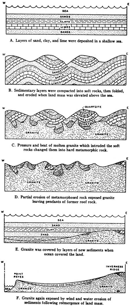
The oldest rocks of the Point Reyes Peninsula are the metamorphosed crystalline limestone and schist which appear as roof pendants (remnants) in the granitic rock. These rocks are older than the granitic rock which engulfed them and were originally deposited as layers of sand, clay, and soft lime in a shallow sea (figure 5a).
|
| Figure 5. Diagrammatic sequential cross sections illustrating general geologic history of Point Reyes Peninsula. |
Millions of years later the sediments had become compacted and perhaps had been uplifted and folded by great earth movements (figure 5b). They were invaded by a mass of molten rock rising from the depths of the earth, which solidified into granite (figure 5c). The heat and pressure caused by this granite intrusion changed, or "metamorphosed", the old sedimentary rocks into the hard quartzites and crystalline schists and limestones now seen as remnants or roof pendants. Their age is unknown, but they are older than the granitic rock which engulfed them. The age of the granitic rock has been determined by Curtis and others (1958) to be about 84 million years (middle Upper Cretaceous).
The granite is exposed continuously between Tomales Point and Mt. Wittenburg near Olema, and it forms the prominent cliffs at Point Reyes. At the time the molten granitic material was emplaced, it could have been hundreds of miles south of its position today. This possibility is not hard to envisage since granitic rock similar to that of Point Reyes is present on the mainland or east side of the fault in the Tehachapi Mountains at the south end of the San Joaquin Valley; the Point Reyes granitic rock could once have been part of that mass.
Following the emplacement of the molten granitic material 84 million years ago, millions of years probably elapsed while it cooled and solidified.
The solidified granite and its covering of metamorphosed sediments were lifted up to form mountains, which were then eroded by wind and rain (figure 5d). Probably most of the metamorphosed sediments and part of the granite had been eroded away when the sea started to encroach again (figure 5e). The oldest sediments found lying on top of the granite are Paleocene in age, or about 60 to 70 million years old. At Double Point Paleocene rocks cored in a deep well are quite fine-grained and marine, suggesting fairly deep sea at this locality; but at Point Reyes itself the Paleocene is a coarse conglomerate, suggesting shallow water and proximity of land. The conglomerate contains pebbles and cobbles of lava and other rock not found now in the vicinity. Their hardness and roundness suggest they may have been derived from an earlier conglomerate of which there is no other evidence today. Perhaps in late Cretaceous time, the granitic basement was uplifted above the sea in the vicinity of Point Reyes, and a conglomerate was formed which was afterwards reworked by the sea when faulting was renewed in Paleocene time. This supposition does not seem unreasonable, since Cretaceous rocks are present west of the San Andreas fault at Gualala to the north and at Montara Mountain to the south, although not exposed in the Point Reyes Peninsula. Similar lava cobbles are found in Paleocene conglomerate at Carmel Bay.
Thus, in the vicinity of Point Reyes, the land must have risen to some extent above the sea in Paleocene time 60 to 70 million years ago (figure 5f). No trace of Cretaceous or Paleocene rocks on the granitic basement along Inverness Ridge has been found, suggesting they were never deposited there.
The next episode of which we have evidence is the sinking under the sea of the Point Reyes Peninsula, including Inverness Ridge and Tomales Point, in early Miocene time 20 to 25 million years ago, with the resultant widespread deposition of the Miocene Laird Sandstone, derived from the granitic rock of the area. The land was covered gently by the sea, and the Laird Sandstone accumulated in shallow water as the sea advanced. In the lower spots, considerable thicknesses of Laird Sandstone accumulated.
As Miocene time continued, the supply of sandy material diminished as the granitic mass was covered by the sea. The conditions offshore then became similar to those at many other localities in central California that were favorable to the deposition of Monterey Shale. These conditions as listed by Bramlette (1946) include: (a) fairly deep marine basins off shore, (b) a minimum of clastic material being brought into the basin, and (c) high availability of silica, possibly due to vulcanism, resulting indirectly in the widespread development of diatomaceous rocks.
Somewhat similar conditions prevail today in the marine basins off the coast of southern California (Emery, 1960).
During Miocene time 10 to 25 million years ago, the Point Reyes Peninsula rocks were situated 100 miles or more southeast of their present position. Post-Miocene lateral movement on the San Andreas fault amounted to 125 miles, which would mean that the Point Reyes Miocene was laid down when the underlying rocks were situated about where the Pinnacles National Monument is today (Berry and others, 1966).
No individual ash beds or lavas are seen in the Miocene of Point Reyes Peninsula. Nevertheless, the Miocene Monterey Shale of Point Reyes contains very fine-grained, ash-like material, which indicates that volcanic activity was close enough for the ash to be carried into the area by wind. Conditions were favorable for the formation of the siliceous Monterey Shale in the offshore basins which must have existed at that time.
The area continued to submerge during the Miocene epoch. The late Miocene marine sediments are much more widespread than the middle Miocene, indicating the continuation of the relative sinking of the land areas during late Miocene time. At the end of Miocene time, most of the peninsula mass was under the sea. Perhaps it resembled the Channel Islands as seen from Santa Barbara.
The next page in the geological story is represented by the Pliocene Drakes Bay Formation, which forms the white cliffs of Drakes Bay. The sandstone at the base of this formation has been determined to be a little less than 10 million years old. It must, therefore, have been laid down very soon after the end of Miocene time; however, a retreat and reinvasion of the area by the sea are indicated by the widespread, coarse, glauconitic sand developed at its base.
This basal greensand contains many bones of sharks and marine mammals, indicating that the water in which it was laid down was quite shallow. In the northern part of the area, there is a strong unconformity between the Pliocene Drakes Bay Formation and the underlying Miocene (photo 30), showing that in that part of the Peninsula at least, the Miocene beds were uplifted between Miocene and Pliocene time and eroded, after which the Drakes Bay beds were laid down on top of them unconformably. The existence of this unconformity to the north suggests that deeper water lay to the south, in the direction of the La Honda Basin.

|
| Photo 30. Miocene-Pliocene unconformity near the U-Ranch. The Pliocene Drakes Bay Formation overlies contorted Miocene Monterey Shale on the east side of the Point Reyes syncline. |
The predominance of very fine-grained material in the Drakes Bay Formation suggests that little granitic rock remained above water at this time. Much of the siltstones and mudstones of this formation may well have been formed by the reworking of Monterey Shale, which they resemble closely except for the lack of rhythmic bedding. Many of the diatoms in the Drakes Bay Formation are Miocene varieties which may also have been reworked, although they may well have survived into early Pliocene times.
Probably before deposition of the Pliocene Drakes Bay Formation ceased, deposition of the younger Merced Formation commenced in the depression occupied by the fault zone near Bolinas, seems likely that the depositional basin of the Merced Formation at Bolinas was connected by a seaway to the depositional basin of the type area south of San Francisco and east of the fault zone. The sea was shallow as indicated by abundant fossils in the formation. However, the type section at Seven Mile Beach is 5000 feet thick compared with a few hundred feet at Bolinas. Perhaps the Bolinas depositional basin was a shallow inlet comparable to Tomales Bay today, connected with the main depositional area of the Merced which lay to the southeast. This main depositional area to the southeast was also a sheltered basin (Glen, 1959) and apparently was separated by land (Inverness Ridge, probably) from the Bolinas basin of deposition.
The Merced Formation of the Point Reyes Peninsula did not extend up the fault zone beyond the topographic high at Five Brooks, unless subsequent erosion has removed it. (The so-called "Merced" formation of the Dillon's Beach area is different in lithologic facies from the type area and from the Bolinas area; it seems not to have been connected to the Bolinas area, but to have been laid down in a sea which extended east toward Petaluma.)
At the end of the deposition of the Merced Formation, the sea was becoming very shallow in the Bolinas area. The topmost beds of the Merced Formation are sands and gravels such as might have accumulated in a backbeach area. The age of these beds is possibly Pleistocene like the top section of the Merced Formation in the type area.
At about this time, or possibly a little later, beds of a very different kind were being laid down at the Tomales Bay end of the fault zone depression. The high area around Five Brooks exhibits rocks of the Franciscan Formation at the surface, indicating that, if any beds of Pliocene-Pleistocene age were laid down in that vicinity, they were subsequently eroded. But northwest of Five Brooks, a large Pleistocene fresh-water lake developed in the fault zone depression, extending as far north as Point Reyes Station or perhaps Millerton. Beds laid down in this lake include silty mudstones containing fresh-water diatoms and gravelly beds of white "granite wash" derived from the west. These fresh-water lake beds form the Olema Creek Formation. (Today no granitic rocks are present close to Five Brooks; but, assuming right-lateral movement has been continuous on the San Andreas fault, they could well have been immediately west of the fault zone when the granitic debris was deposited in the Olema Creek Formation.) The exact age of this formation is unknown, but the following facts are helpful in dating it.
(1) It contains fresh-water diatoms which are all Holocene forms.
(2) It contains remains of tree trunks with a C—14 age of about 38,000 years.
(3) It is quite young in appearance and degree of consolidation.
(4) It dips at angles as steep as 45 degrees.
(5) It has apparently moved southeasterly down the fault zone at least some 12,500 feet which, assuming a rate of movement of 2 inches per year, would suggest an age of 75,000 years.
It is not known how far north these fresh-water beds extended; however, mudstone of a similar appearance underlies the terrace deposits at Point Reyes Station, and at Millerton the lowest beds are reported to be fresh-water deposits (Mason, 1934). The marine fossiliferous beds overlying them are reported to be more than 50,000 years old (Richards and Thurber, 1966).
Thus, the Olema Creek Formation is probably partly contemporaneous with the Millerton Formation (late Pleistocene).
The Bolinas—Drakes Bay terrace extending discontinuously from Bolinas to Drakes Bay consists of a prominent wave-cut platform overlain by landlaid terrace deposits (photo 21). The terrace deposits consist almost entirely of Monterey Shale debris washed off the nearby steep hills. At its base is a thin bed resembling a soil and a layer of rounded pebbles.
To account for the formation of this terrace, we must first postulate a high stand of the sea in post-Merced time, with wave erosion forming the wave-cut platform on which the town of Bolinas stands and on which the terrace deposits were laid down further north. Then the sea retreated, possibly to a level considerably lower than present sea level, thus uncovering the flat platform which had been cut by the waves in the underlying rocks. The wave-cut platform was then tilted northward by tectonic forces; terrestrial deposits accumulated on its tilted surface and formed a new level surface with a thicker section at Drakes Bay than near Bolinas. Then the sea gradually rose to its present level, and nearly all of the once extensive terrace was eroded away. The retreat of the sea cliff in these soft beds could be on the order of at least a foot a year, so that in 50,000 years the cliff has been eroded back many miles.
Subsequent earth movement has lowered the terrace deposits below present sea level at Drakes Bay. It seems possible too that there has been some tectonic uplift at Bolinas and at Tomales Point, though this movement is difficult to separate from the eustatic changes in sea level.
As mentioned earlier, it seems very likely that the age of the Bolinas—Drakes Bay terrace is about 100,000 years. Studies of the great Ice Age of the Pleistocene show that there was a marked melting of the ice caps in the Sangamon interglacial stage about 100,000 years ago. The water derived from this melting ice raised sea level everywhere and no doubt caused the marine incursion which formed the Bolinas-Drakes Bay wave-cut platform. Subsequently the sea retreated again as more water was frozen in the increasing ice caps of the Wisconsin glaciation. The melting of the ice caps since that time (about 20,000 years ago) has resulted in a rise in sea level from about 125 meters to the present sea level. This is the marine transgression referred to as Flandrian by Cooper (1967) in his work on the coastal sand dunes.
Numerous obscure terraces are present along the coast at elevations higher than the Bolinas-Drakes Bay terrace, but they are too discontinuous to draw any conclusions about the geological history they represent. The same applies to the mature rounded land forms to be seen at higher elevations along Inverness Ridge. One group of deposits however, deserves mentioning here because they do give information about the past. These are the terraces with cobbles of Franciscan chert mentioned on page 44. It seems necessary to assume that these Franciscan Formation remains came from east of the fault zone and in a downhill direction so that they must have crossed the fault zone before it was eroded by streams. If so, they must have been deposited long ago, perhaps in late Pliocene times or early Pleistocene.
| <<< Previous | <<< Contents >>> | Next >>> |
state/ca/cdmg-bul-202/sec6.htm
Last Updated: 28-Nov-2007