
|
Geological Survey Bulletin 845
Guidebook of the Western United States: Part F. Southern Pacific Lines |
ITINERARY
|
|
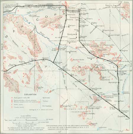
SHEET No. 23 (click in image for an enlargement in a new window) |
MAIN LINE, PHOENIX TO WELLTON, ARIZ.
|
Tolleson. Elevation 1,100 feet. Population 910. New Orleans 1,631 miles. |
West from Phoenix the railroad follows the wide Salt River, with its highly cultivated district of irrigated fields, through Fowler, Cowden, and Cashion sidings and the town of Tolleson.53 At Cashion is a large power plant made conspicuous by its high stacks. In this district alfalfa, cantaloupes, head lettuce, and cotton are the principal products, and many cattle are pastured.
53Incorporated in 1929; named for W. G. Tolleson, one of the original settlers.
|
Litchfield. Elevation 971 feet. Population 250.* New Orleans 1,636 miles. |
Near Litchfield the route crosses the Agua Fria River (ah'gwa free'ah, Spanish, for cold water), a stream that drains a mountain region of volcanic rocks, schists, etc., to the north in which considerable mining is done. Southeast of Litchfield is the junction of the Salt and Gila Rivers near the north end of the Sierra Estrella (es-tray'ya), a high and exceptionally rugged range of schist that extends far southward. A short distance, farther east, the Santa Cruz River, when flowing, empties into the Gila River. Litchfield, Norton, and Liberty are small settlements where a considerable area of desert land has been reclaimed by irrigation. (Turn to sheet 24.) West of Liberty, however, there is a zone about 4 miles wide in which the soil appears to be too much mineralized for agriculture.
|
|
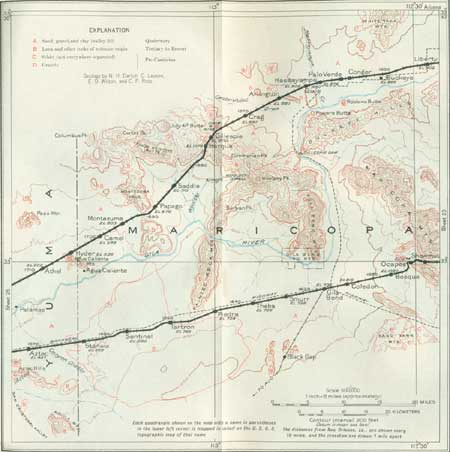
SHEET No. 24 (click in image for an enlargement in a new window) |
|
Buckeye. Elevation 886 feet. Population 1,077. New Orleans 1,651 miles. |
At Buckeye, on the north side of the Gila River, wide fields of alfalfa, cotton, grains, and other crops are irrigated by a canal from the Gila near the mouth of the Agua Fria. Alfalfa seed is an important product. The canal is 20 miles long and provides water for nearly 20,000 acres. Considerable water also is pumped from the underflow from the Gila River, some of the wells yielding 200 gallons a minute. An irrigation district on the south side of the valley uses water pumped from the Gila River. North of Buckeye are the rocky slopes of the White Tank Mountains, which consist of light-colored massive schists and granite cut by small dikes of pegmatite, diabase, and other igneous rocks. A few remnants of lava have been reported in this range.
The Buckeye Hills, south of Buckeye, are irregular buttes and hills of granite and schist, part of a wide area of pre-Cambrian rocks constituting an extensive land surface that probably persisted through most of Paleozoic and later time. Granite appears near the river bank southeast of Liberty and Buckeye. West of Buckeye the road continues along the north side of the Gila Valley, passing through several sidings used to some extent as shipping points for the many ranches in the district, most of them sustained by irrigation. Just beyond Hassayampa siding the creek of that name is crossed. It drains an area of moderate extent in the northern part Maricopa County. There is a legend widely quoted in Arizona that the veracity of persons who have quenched their thirst with the water of Hassayampa Creek can never be relied on. Thirty miles to the north is the Vulture mine, on the south slope of the Vulture Mountains, which for a time was a notable producer of silver.54 The famous Vulture lode, discovered in 1863, yielded ore containing more than $4,000,000 in gold (Yearbook of Arizona, 1930).
54The Vulture Mountains consist of volcanic rocks of Tertiary age lying on pre-Cambrian schists cut by granites and other igneous rocks.
Not far beyond Hassayampa, near Dixie siding, there are small areas of recent lava, and Robbins Butte and Powers Butte, on the south bank of the Gila River, are conspicuous remnants of lava. In Powers Butte the lava caps sandstone, probably of Tertiary age. Here the Gila River bends sharply southward around the west end of the Buckeye Hills, but the railroad takes a southwesterly course. Near Arlington there is a small irrigation district using river water. Alfalfa is the principal crop, and most of it is used to feed cattle. Five miles south of Powers Butte, at a point where the valley is greatly narrowed by a lava flow,55 the Gillespie Dam impounds the river water. This dam, built by F. A. Gillespie in 1921, is a concrete structure 1,800 feet long which conserves water for the irrigation of about 100,000 acres below Gila Bend, including the Indian reservation that occupies a long strip of bottom lands northwest of the town. The geologic relations at this dam are shown in Figure 59.
55The lava that occupies the plain west of the Gillespie Dam is relatively recent and no doubt blocked the valley for a while and caused a temporary lake. Indistinct terraces in the Arlington Valley, especially on the edge of the basalt hills north of Arlington village, seem to indicate that the lake extended to that place. Probably at that time most of the water of the Gila River escaped westward through the pass in the Gila Bend Mountains. Terraces leading into the pass were doubtless formed then, for they could not have been developed by the small stream now heading in the pass. The Gila River was probably also dammed by the lava flow north of Sentinel, for the present channel is in a gap cut through the lava. The west end of the Buckeye Hills is composed of thin sheets of andesitic lava interbedded in sandy shales and conglomerate of Tertiary age. The conglomerate carries angular pebbles as much as 6 inches in length.

|
| FIGURE 59.—Section across the valley of the Gila River at Gillespie Dam, Ariz. After C. P. Ross. Ql, Quaternary lava; Tl, Tertiary lava; Ts, Tertiary sandstone; Agr, granite. |
From Arlington the railroad descends into the broad valley of Centennial Draw, so named because it is about 100 miles in length from the most remote portion of the basin which it drains. The lower part of its course is through a thicket of mesquite. The route continues southwestward on an upgrade of about 200 feet to a pass through the Gila Bend Mountains, thus avoiding the big bend of the Gila River. On this grade there are fine views to the northwest showing very prominent buttes, peaks, and ridges of volcanic rocks rising steeply from wide desert valleys. The most conspicuous of these is Saddle Mountain, more than 2,000 feet high, which takes its name from a deep saddle-shaped depression in its top. These features mark a center of great volcanic activity in Tertiary time, with the outpouring of thick sheets of lava and a large amount of ash and tuff.56 The sheets of these materials have been gently tilted and flexed and considerably faulted, and erosion has cut wide valleys that isolate the ridges. In Saddle Mountain the beds are broken by many faults. The rocks underlying this region are granite and schist of pre-Cambrian age which present a rolling surface under the volcanic deposits.
56According to C. P. Ross the rocks in Saddle Mountain consist of fine-grained reddish latites, hornblendic felsites, and gray vesicular basalts. There are also considerable thicknesses of fragmental rocks, mostly volcanic agglomerates and breccias. Some of the rounded forms and hollows appear to be due to a disposition to curved exfoliation and not the result of solution or erosion. The Palo Verde Hills, which lie just east of Saddle Mountain, consist mostly of the younger basalt, but a butte hear the Palo Verde mine is a fine-grained hornblende granite.
West of Crag the railroad reaches outcrops of lavas and other volcanic rocks which are extensively displayed in the pass at the divide near Harqua and in many surrounding ridges.
In this desolate region the desert flora is well represented by various cacti, including scattered sahuaros, many covilleas, and much palo-verde and mesquite, the last named being most conspicuous along the dry washes. The volcanic succession has great thickness in the prominent flat-topped Woolsey Peak,57 which is conspicuous to the south at intervals from Crag to Gillespie. Ciminerian Peak is the highest point on a prominent serrated ridge which extends to July 4 Butte and probably marks a great igneous dike. The old mail road from Phoenix to Yuma crossed these mountains in a pass between Ciminerian and Woolsey Peaks and, descending Woolsey Arroyo, reached the bank of the Gila River at Agua Caliente (ca-liane'tay). It passed Woolsey Well, formerly a favorite camping place, about 3 miles west of Woolsey Peak, where some interesting geologic features are exposed. The basement lavas are overlain by conglomerate and sandstone of Tertiary age, tilted gently to the west. These rocks are capped by a sheet of basalt and intersected by several dikes and sills of basalt. Some of the boulders in the conglomerate are from 1 to 3 feet in diameter.
57Named from King Woolsey, the pioneer settler on the Gila River who engineered the "Pinole treaty," in which many Indians, invited to come unarmed to a feast and council, were treacherously set upon and slaughtered by their host and his friends.
About 2 miles northwest of Gillespie is the Old Dixie mine, where shale and andesitic agglomerate are cut by quartz monzonite porphyry that was probably intruded in Tertiary time.
|
Harqua. Elevation 1,078 feet. New Orleans 1,677 miles. |
On approaching Harqua siding the railroad passes through cuts of granite in a small exposure in the midst of the volcanic succession. From the divide at Harqua siding there is a rapid descent into the wide alluvial flat of Quail Spring Wash. To the north from a point near Saddle siding there is an excellent view of Yellow Medicine Butte, which consists of a high southward-sloping cuesta of basalt capping a thick mass of tuffs. A fault traverses this cuesta, breaking it into two portions. This succession and the basement of granite on which it lies is general throughout the region, notably in the Montezuma Cuesta and its companion to the south; in Columbus Peak, where the dip is 20°; and in the Agua Caliente Mountains. The relations are shown in Figure 60.

|
| FIGURE 60.—Section in Yellow Medicine Butte and adjoining mountains, Arizona. Tb, basalt; Tc, conglomerate; Tt, light tuff; Ta, andesite, etc.; Agr, granite. |
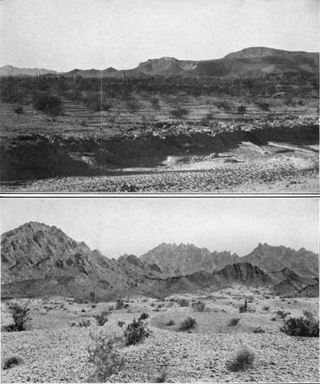
Beyond Papago siding a gap leads between basalt-capped mesas. Passing Montezuma and Camel sidings the lowlands on the north side of the Gila River are entered. To the north is a fine view of a feature known as Montezuma Face, which, as shown in Plate 32, A, presents a remarkably natural face profile looking upward.
|
|
PLATE 32.—A (top), MONTEZUMA FACE, NORTHEAST
OF HYDER SIDING, ARIZ. A remarkable profile on the mountain slope. B (bottom), NORTHERN PART OF MOHAWK MOUNTAINS, ARIZ. Consisting of sandstone, shale, and conglomerate of Tertiary age, steeply tilted. Looking south-southeast. (E. D. Wilson.) |
|
Hyder. Elevation 536 feet. Population 20.* New Orleans 1,704 miles. |
At Hyder the railroad passes north of the basalt-capped mesas known as the Agua Caliente Mountains, the slopes of which are covered with talus. A big dike in the hill just north of the railroad extends southward under the northernmost of these mesas. At the south end of these mesas are the warm springs at Agua Caliente (Spanish for hot water), where a health resort has been established to utilize the water. The priest-explorer Sedelmaier visited them in 1748, and Garcés and Font mention them in their diaries of the Anza expedition of 1775. For a long time Agua Caliente was a station on the old stage road that crossed the mountains near Woolsey Well.
Sahuaros occur on the plains and hillsides nearly to Athel siding, together with widely spaced bushes, mainly Covillea.
At Athel siding the sharp peaks of Pass Mountain, a group of volcanic buttes 8 miles to the north, are seen, and northwest of Athel and north from Horn to Kofa (turn to sheet 25) the Palomas Mountains are conspicuous. These mountains consist of a cap of basalt on a thick deposit of volcanic tuff and ash, which lies on and against granite that constitutes the western range of the mountains.
|
|
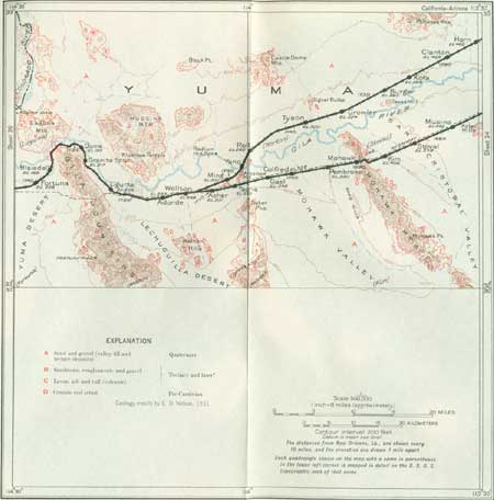
SHEET No. 25 (click in image for an enlargement in a new window) |
|
Horn. Elevation 468 feet. Population 25.* New Orleans 1,714 miles. |
From Horn to Growler siding and beyond the desert plain is covered with low sand dunes. In this vicinity the railroad approaches the north bank of the Gila River in the midst of a wide desert plain into which the river has cut a broad inner trench about 50 feet deep. The stream meanders widely in this alluvial flat, and for many miles the south bank of the trench presents a long line of northward-facing cliffs of sand, loam, and gravel. The region is arid, with an annual rainfall of less than 5 inches in the lowlands, and consequently vegetation is very sparse. Yet there are scattered cattle ranches and goat or sheep outfits, and in seasons of average rainfall and where drinking water is provided the stock business has prospered. The river is one good source of supply, and in the adjoining region water is obtained from widely scattered wells, mostly of considerable depth and yielding only a moderate volume. In the mountains of the general region there has been a small amount of mining or prospecting, but the results do not appear to have been satisfactory.
At Burger siding Texas Hill is visible to the south, evidently a feeder for a small flow of basalt. The Anza-Garcés expedition, which followed the north bank of the river for a few miles, camped at the foot of this hill on the night of November 16, 1775. Signal Butte, northwest of Growler, is of similar character. In this vicinity the Mohawk Mountains (p. 232) are a prominent feature to the south. About 30 miles to the north the steep western front of the Kofa Mountains is conspicuous. At its foot were the King of Arizona, North Star, and other gold mines, which at one time, it is claimed, yielded nearly $5,000,000 in gold and silver, much of it from very high grade ore, some of which assayed as high as $20,000 a ton (Yearbook of Arizona, 1930). The ore bodies were in veins in volcanic rocks (andesites) of Tertiary age.
North from Tyson siding the peaks of the south end of the Castle Dome Mountains are conspicuous. They consist of a central core of schist, heavily flanked by lavas of Tertiary age. Far to the north may be seen the culminating summit, Castle Dome Peak, which is a prominent landmark in a region of wide extent. This peak was called Bauquiburi by the Indians and was often referred to in the narratives of early travel as the Cabeza del Gigante (ca-bay'sa del he-gahn'tay, Spanish for head of the giant). There are mines near its base on the west slope of the range.
|
Roll. Elevation 265 feet. Population 40.* New Orleans 1,745 miles. |
South of Roll the prominent, sharp Baker Peaks are in view south of the Gila River, and beyond them the rugged crest of the Copper Mountains. Roll is a small settlement sustained by irrigation, using water pumped from sand and gravel holding underflow from the river. To the west are the prominent Muggins Mountains, and to the north the west side of the Castle Dome Mountains is conspicuous. The wide river terraces to the west are deeply trenched by arroyos.
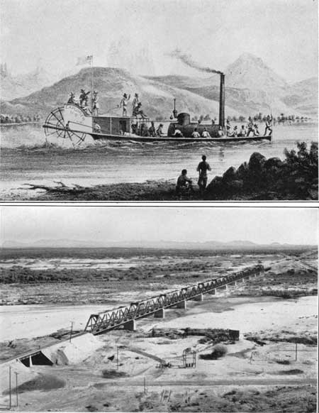
Just west of Roll the railroad line bends southwestward toward the Gila River, which is crossed at the north end of Antelope Hill, as shown in Plate 33, B. This hill is composed of light-colored arkose and arkosic sandstone supposed to be of Tertiary age, of which about 500 feet is exposed, dipping to the south at a low angle. Other exposures of the same rock constitute the north end of the Mohawk Mountains, as shown in Plate 32, B, the two knobs a mile southwest of Ming siding, and the Baker Peaks, southeast of Ming. The rock is quarried extensively at two places near the river.
|
|
PLATE 33.—A (top), THE "EXPLORER" A drawing of
the steamboat used by the Ives expedition up the Colorado River. B (bottom), VIEW NORTHWARD ACROSS THE GILA RIVER FROM ANTELOPE HILL, BETWEEN WELLTON AND ROLLS, ARIZ. Castle Dome Mountains in distance; irrigated fields in middle ground. |
After crossing the Gila River the railroad turns to the south-southwest and, rising onto the wide upland terrace, here 50 feet above the river flat, joins the old main line at Wellton.
|
Wellton. Elevation 258 feet. Population 80.* New Orleans 1,756 miles. |
Wellton is a local trading settlement for the cattle and irrigation industry and a headquarters for mining interests of the surrounding country. There is considerable irrigation near by and for a few miles west from wells and from ditches taken out of the Gila River. The village is situated on a wide desert plain 2 or 3 miles south of the river. High mountains are visible on all sides. To the north are the Muggins Mountains, an irregular series of high ridges of Tertiary volcanic rocks heavily flanked to the east and south by conglomerates and other strata of later Tertiary age. Farther north are the high pinnacles and ridges of the Castle Dome Mountains. To the west are the lofty Gila Mountains, consisting of granite and schist; to the south are many low ridges of schist, making the Wellton Hills; and to the southeast the Baker Peaks and the Copper Mountains, referred to above. To the north is an irrigated district of considerable size which is closely approached by the railroad near Adonde siding.
| <<< Previous | <<< Contents >>> | Next >>> |
bul/845/sec24.htm
Last Updated: 16-Apr-2007