
|
Geological Survey Bulletin 845
Guidebook of the Western United States: Part F. Southern Pacific Lines |
ITINERARY
|
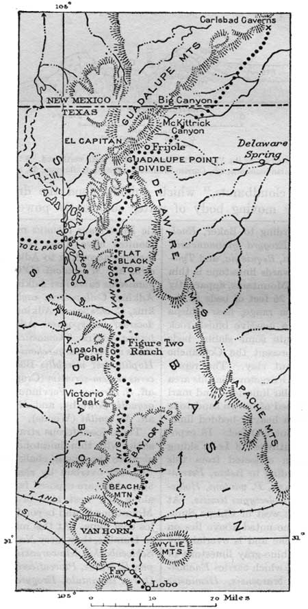
| FIGURE 17.—Map showing route from Lobo, Tex., to Carlsbad Caverns, N. Mex. |
SIDE TRIP TO CARLSBAD CAVERNS, N. MEX.
At Lobo passengers can make arrangements for motor transportation to Carlsbad Caverns by way of Van Horn, a distance of about 100 miles nearly due north. The route is shown in Figure 17. There are regular busses and a 1-day airplane excursion from El Paso to the caverns, a distance of 140 miles. The caverns are on the southeast slope of the Guadalupe Mountains and extend far and deep underground in a series of superb chambers containing a great variety of beautiful stalactites, stalagmites, and other depositional forms of calcium carbonate. (See pl. 16, B.) The road northward from Van Horn skirts the outlying ridges of Beach and Baylor Mountains and the foot of the Sierra Diablo, on the west side of Salt Basin, a wide desert valley of which the Lobo Flats are a southern extension. This valley is without outlet. The mountains adjoining it consist mainly of limestones and sandstones lying nearly horizontal and presenting a most interesting succession of 5,000 feet or more of Paleozoic strata, with the underlying pre-Cambrian sandstones, limestones, and schists exposed to the south.73
73The principal features of the formations in this region are given in the following table:Formations in the Van Horn region
Age Formation Character Thickness
(feet)Cretaceous. sandstone and limestone. 1,800+ Permian. Limestone, mostly massive, light to dark, many reefs. (Lies unconformably on older strata down to pre-Cambrian.) 2,800 Pennsylvanian. Limestone, massive, on dark shale. 800 Devonian?. Chert and dark slabby shale. 150 Silurian. Fusselman. Dolomite, massive, light. 100+ Ordovician. Montoya. Limestone, cherty, with basal brown sandstone member. 400 El Paso. Limestone, massive, mottled, lower part sandy. 1,000 Upper Cambrian. Van Horn. Sandstone, red arkose conglomerate lenses and basal member. (Lies unconformably on pre-Cambrian.) 20-700 Pre-Cambrian. Millican. Limestone, massive, thinly banded with chert; carries masses of Cryptozoon.
Sandstone, red, in part argillaceous and conglomeratic.
Conglomerate, including schist fragments. Cut by sills of diabase and carries interbedded lava flows.3,000± Carrizo Mountain. Schist and gneiss cut by igneous rocks and veins of quartz and pegmatite.
The pre-Cambrian schist constitutes the Carrizo Mountains, which lie between the Texas & Pacific and Southern Pacific Railroads west of Van Horn. It is also exposed in a few small areas in the adjacent region. The Millican formation, which contains much red shale and cherty limestone, resembles the Grand Canyon series and Apache group of Arizona. It constitutes an area of foothills northwest of Van Horn. Although undoubtedly it is younger than the schist, the two formations are separated by faults, a feature well exposed a short distance north of Eagle Flat station on the Texas & Pacific Railway, where the limestone of Permian age overlaps both. The presence of schist fragments in the conglomerate and the lesser degree of metamorphism of the Millican beds indicate that they are younger than the schists, doubtless of Algonkian age. The Van Horn sandstone lies on an irregularly eroded surface of the pre-Cambrian rocks. It is several hundred feet thick in the ridges northwest of Van Horn, but it thins out in places, together with the overlying old limestones, so that the limestone of Permian age lies directly on the Millican formation or on schist. In part of the area the Permian limestone lies directly on El Paso limestone, as shown in Plate 15, A. In places the Van Horn beds, especially the lower ones, consist largely of coarse material including fragments of red granite and porphyry of pre-Cambrian age which probably formed a shore near by, now covered by later sediments. Much of the Van Horn material is of red color. The succession of El Paso to Fusselman limestone which largely constitutes Beach Mountain and some of the foothills about the Baylor Mountains, north of Van Horn, is very similar to the formations in the Franklin Mountains north of El Paso and contains the same fossils. Some of them can also be correlated with strata in the Marathon uplift. These limestones thin out to the south and west. They also appear in the foot of the Sierra Diablo, 25 miles north of Van Horn, just west of the road to the Carlsbad Caverns. The Fusselman limestone contains a characteristic Pentamerus; the Montoya contains Columnaria, Halysites, Streptelasma, Rhynchotrema, and Rafinesquina of the Upper Ordovician; and the El Paso limestone contains Piloceras, Eccyliomphalus, Hormotoma, and Ophileta of the Lower Ordovician.
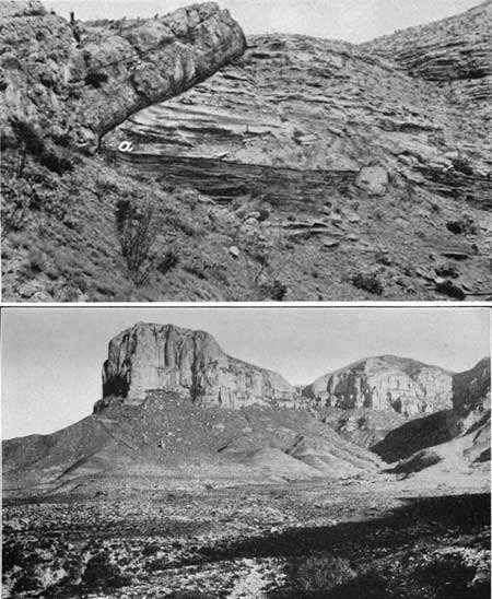
PLATE 15 A (top), PERMIAN LIMESTONE LYING UNCONFORMABLY ON EL PASO LIMESTONE AT SOUTH END OF BAYLOR MOUNTAINS, 12 MILES NORTH OF VAN HORN, TEX. a. Contact of Van Horne sandstone.
B (bottom), GUADALUPE POINT, TEX. The south end of a great promontory of Capitan limestone on Delaware Mountain beds. El Capitan, the highest peak in Texas, at the right.
The Permian succession that constitutes the great mountain block of the Sierra. Diablo, the Baylor and Wylie Mountains, and some minor ridges consists mostly of limestones of various kinds presenting considerable variety of fossil assemblages. The thickness remaining in the high eastern front of the Sierra Diablo is 2,700 feet. During Permian time there was nearly continuous subsidence and deposition in the region, uninterrupted by uplift or extensive incursions of coarse sediments. Evidently there were long reefs which persisted during the deposition of thousands of feet of strata. The position and extent of land at that time in the general region are not known. These reefs had a controlling effect on the sedimentation. In the open sea in front of them were deposited materials now represented by flaggy black limestones, siliceous shales, and fine sandstones which contain such Guadalupian fossils as Richthofenia and Leptodus. Behind the reefs were lagoons in which were deposited sediments now represented by thinly stratified dolomite containing fusulinids in extreme abundance. Farther behind, to the west and southwest, there were accumulations of limy sediments with a fauna like that in the Hueco Mountains, including Omphalotrochus, Bellerophon, Productus peruvianus, and Spirifer condor. The reefs consist of very massive limestones or dolomites, built of the remains of algae, bryozoans, sponges, crinoids, and other fossils adapted to reef environment.
The Permian of the Wylie and Baylor Mountains consists of limestones laid down behind the reefs. In the Sierra Diablo a thick body of lagoon limestone constituting the lower third of the series is succeeded by black limestone and other open-sea deposits cropping out in rounded slopes, which are surmounted by great cliffs of the reef limestone. Some of the relations of these strata are shown in Figure 18. In places in the escarpment there is an abrupt transition from black limestone to reef limestone. At the north end of the Sierra Diablo, 40 miles northwest of Van Horn, the reef limestones are overlain by sandstones of the Delaware Mountain formation, a remnant of the thick succession of pre-Capitan strata well developed in the Delaware and Apache Mountains, on the east side of Salt Basin. (P. B. King.)
|
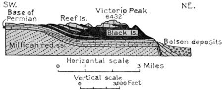
| FIGURE 18.—Section of east front of Sierra Diablo at Victorio Peak, 18 miles north of Van Horn, Tex. By P. B. King. |
The Sierra Diablo is an elevated plateau sloping gently westward and presenting to the east an imposing escarpment 2,000 to 2,500 feet high. Its highest summit, Victorio Peak, is 6,432 feet above sea level. It is due to an uplift by which the strata were raised several thousand feet by a long south to north fault or zone of faults that extends along its foot. In places the downfaulted strata are exposed dipping steeply to the east, as shown in Figure 18, and in the slopes 25 miles north of Van Horn there are small but steep escarpments in. the alluvial fan, which probably indicate recent movements along this fault zone.
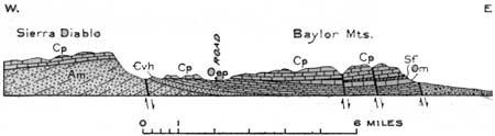
To the southwest the Sierra Diablo is separated from Salt Basin by Beach Mountain and the Baylor Mountains, fault blocks both, the latter having the relations shown in Figure 19.74
74In these mountains the Permian limestones are separated from the Millican beds (pre-Cambrian) by Fusselman, Montoya, and El Paso limestones and Van Horn sandstone, occupying a local basin of moderate size. There are overlaps of the various formations. Several faults trending northwest cross the southern part of the Sierra Diablo region and it is through a gap along one of these breaks that the Texas & Pacific Railway crosses the range west of Van Horn. In this gap the Permian limestone, capped in places by strata of Comanche age, lies directly on the Van Horn sandstone. The Comanche beds here consist mainly of sandstone with some conglomeratic layers and a few thin layers of limestone. At the base. is a 1-foot bed of conglomerate overlain by 10 to 20 feet of impure limestone. About 400 feet remains, an unknown amount of overlying strata having been removed by erosion.
|
| FIGURE 19.—section across the escarpment of the Sierra Diablo and Baylor Mountains, 15 miles north of Van Horn, Tex. By P. B. King. Am, Millican formation; €vh, Van Horn sandstone; Oep, El Paso limestone; Om, Montoya limestone; Sf, Fusselman limestone; Cp, limestones of Permian age |
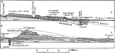
About 35 miles north of Van Horn, not far beyond the Figure Two ranch, the road to the Carlsbad Caverns passes the north end of the Sierra Diablo, where the northerly dip of the great limestone succession carries it rapidly below the surface. In the next few miles the Salt Basin is crossed diagonally and the westward-fronting escarpment of the Apache and Delaware Mountain range is gradually approached. This range consists of limestones and sandstones of Permian age, which also constitute various outlying buttes. Very prominent features to the north are the high white promontory of Guadalupe Point (see pl. 15, B), at the south end of the Guadalupe Mountains, and El Capitan, the culminating peak of that range and the highest summit in Texas (elevation about 8,700 feet). These mountains are capped by a thick succession of light-colored limestone (Capitan limestones) of Permian age which extends to the Carlsbad Caverns. It lies on limestones and sandstones of the Delaware Mountain formation, which are well exposed in the ascent to the divide just east of Guadalupe Point and at intervals farther north. The relations are shown in the sections in Figure 20. It will be seen from the first of these sections that the caverns are in the Carlsbad limestone member, which is a northern extension of the upper part of the Capitan limestone. The strata dip to the east. The opening is on the east slope of the mountains, some distance above the plain underlain by Castile gypsum which here skirts the east foot of the mountains. The opening is a wide natural arch from which a broad stairway and an elevator descend into the cavern, which has a total depth of more than 700 feet. Some of the upper chambers of the cavern are the homes of myriads of bats, which fly out for a nightly foray at sunset every evening in a veritable cloud of wings that darkens the sky; they return at dawn. Many visitors linger in the evening to see the exodus.
|
| FIGURE 20.—Sections across the Guadalupe Mountains at El Capitan, Tex., and Carlsbad Caverns, N. Mex. |
| <<< Previous | <<< Contents >>> | Next >>> |
bul/845/sec16a.htm
Last Updated: 16-Apr-2007