
|
Geological Survey Bulletin 730—A
Peneplains of the Front Range and Rocky Mountain National Park, Colorado |
CONTRIBUTIONS TO THE GEOGRAPHY OF THE UNITED STATES, 1922.
PENEPLAINS OF THE FRONT RANGE AND ROCKY MOUNTAIN NATIONAL PARK, COLORADO.
By WILLIS T. LEE.
PURPOSE OF THIS PAPER
The purpose of this paper is to call attention to some of the major surface features in the Rocky Mountain National Park and to point out their probable correlation with similar features in neighboring regions. The observations on which the paper is based were made in the summer of 1916, during an investigation in which other work demanded first consideration. This paper may therefore be considered a by-product. For the same reason many of the observations were not followed to conclusions, yet the data obtained seem to be sufficient to establish a certain order of events, the recognition of which may be of assistance in working out in detail the geologic and geographic history of the Rocky Mountain region.
TWO CYCLES OF EROSION PREVIOUSLY RECOGNIZED.
In an account of the general geology of the Georgetown quadrangle, Colo., Ball1 describes three distinct types of land forms—"an old, mature mountainous upland; younger V-shaped valleys incised in this upland; and glacial cirques developed at the heads of some of the streams, passing downward into U-shaped valleys." Ball describes the mountainous upland as consisting of highlands of rounded or gently sloping tops which are remnants of an ancient peneplain or old surface of erosion. Most of these remnants in the Georgetown quadrangle lie above an altitude of 11,500 feet. On this old peneplain there were many monadnocks, some of which are now recognizable as the summits of the highest mountains. Similar surfaces of erosion occur elsewhere in the mountains, among them the well-known upland plain near Pikes Peak, recognized by Cross.2 Later Davis3 accepted Ball's description and applied to the high lands the term "a two-cycle mountain mass." This term and other expressions in his paper indicate that Davis believes that only two main cycles of erosion are represented in the Rocky Mountains in Colorado—an older one resulting in the formation of a peneplain and a younger one during which the canyons and cirques were excavated. Hence the remnants of the highland plain found at many places in these mountains are referred to as parts of "the peneplain."
1Spurr, E., and others, Economic geology of the Georgetown quadrangle (together with the Empire district), Colo. [General geology, by S. H. Ball]; U. S. Geol. Survey Prof. Paper 63, p. 31, 1906.
2 Cross, Whitman, U. S. Geol. Survey Geol. Atlas, Pikes Peak folio (No. 7), 1894.
3Davis, W. M., The Colorado Front Range: Assoc. Am. Geographers Annals, vol. 1, p. 42, 1911.
A POSSIBLE THIRD CYCLE.
The dissected plateau near Pikes Peak which Cross described as practically the same as the floor of South Park was recognized by Richardson4 in the Castle Rock quadrangle and by Finlay5 in the Colorado Springs quadrangle. This plateau lies at altitudes between 9,000 and 9,500 feet and is extensively developed in the Front Range in Colorado. From localities at some distance from the mountains this plain appears to be an almost horizontal shelf that extends along the mountain front as far as the eye can reach. The area in which it is best developed and best preserved extends from Denver southward to Pikes Peak. In areas farther north, such as the mountains west of Golden, it is not so readily recognized, but it seems to be represented by surfaces much lower than the highland plain described by Ball as lying above 11,500 feet. Remnants of the lower plain may be recognized from some commanding eminence, such as Mount Lookout, near Golden, Colo., whose summit appears to be a part of the lower peneplain. This plain has become known somewhat widely as the Rocky Mountain peneplain, possibly because it is the most extensive land form in the Front Range. From Mount Lookout may be seen at nearly the same level numerous flat tops, benches, and smooth-floored reentrants (see Pl. I), which are remnants of the Rocky Mountain peneplain. But the best-known view of this peneplain is that which may be had from the side of Pikes Peak at an altitude of about 10,000 feet. From this point the observer looks to the north and west over the tops of the mountain ridges as over a level plain.
4Richardson, G. R., U. S. Geol. Survey Geol. Atlas, Castle Rock folio (No. 198), 1915.
5Finlay, G. I., U. S. Geol. Survey Geol. Atlas, Colorado Springs folio (No. 203), 1916.
|
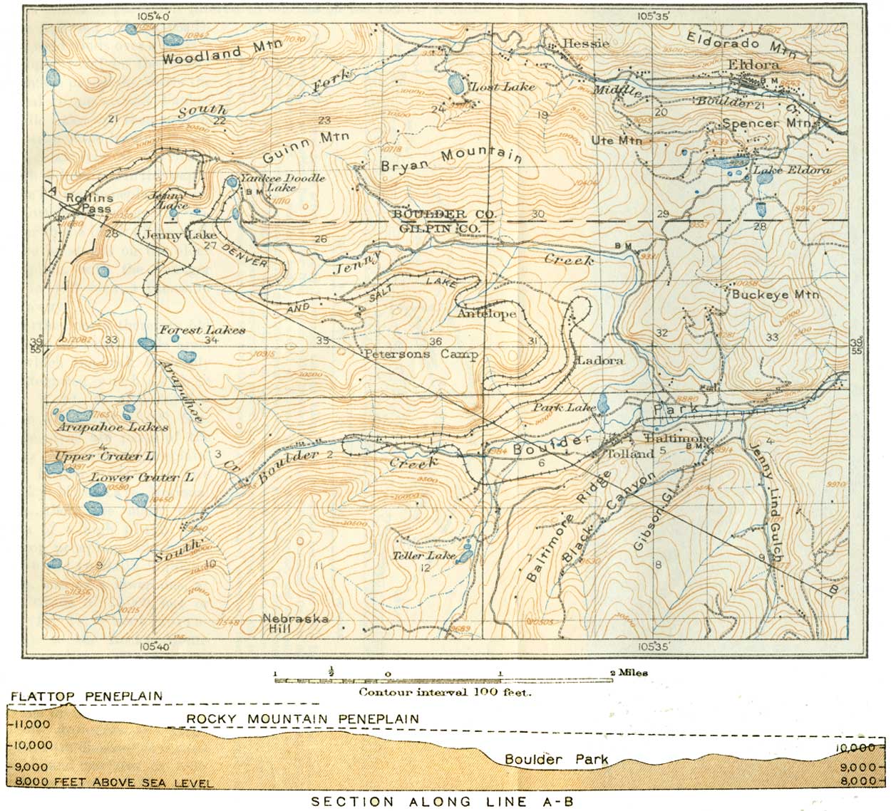
| PLATE I.—MAP AND PROFILE SECTION OF A PART OF CENTRAL CITY QUADRANGLE, COLO. (click on image for an enlargement in a new window) |
The reentrants seem to furnish indubitable proof of a distinct cycle of erosion. The older peneplaned surface was elevated, tilted, and dissected; the plain formed by the coalescing valleys has a slope notably different from that of the higher and older peneplain. A reentrant, possibly modified to some extent by glaciers, seen near Jenny Lake, Colo. (Pl. I), is a part of this new plain. This is one of the points of particular interest to tourists on the Denver & Salt Lake Railroad (Moffat road).
This road winds over a surface of slight relief on the Rocky Mountain peneplain, enters the glacial cirque around Yankee Doodle Lake, and then ascends the steep slope leading to the high peneplain at Corona, which is described in this paper as the Flattop peneplain. Here a short walk brings the observer to the brink of the cliff, where he stands on the older peneplain, with the younger one in full view a thousand feet away.
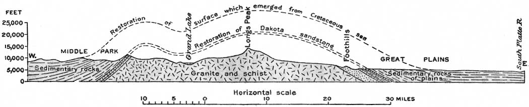
Farther north there are old surfaces of considerable area, on which the rock is deeply disintegrated, such as that near Ward, at altitudes between 9,000 and 10,000 feet. These areas are parts of the Rocky Mountain peneplain. Still farther north, in the Rocky Mountain National Park, there are many remnants of a high plain, the Flattop peneplain, which corresponds to Ball's highland plain, and of a lower one, at an altitude of 10,000 feet or less (fig. 1), which corresponds to the Rocky Mountain peneplain. Both have been deeply dissected by the erosion of deep canyons during the present cycle.
|
| FIGURE 1.—East-west profile across the Rocky Mountains through Longs Peak and Grand Lake, Colo. The Dakota sandstone marks the position of an ancient floor resulting from erosion, which base-leveled the site of the mountains. On this floor were deposited sediments of Cretaceous age. The mountain region was arched at the end of the Cretaceous period, and the sedimentary rocks were eroded. Records of early Tertiary events in the mountain region were destroyed by later erosion. The first definite Tertiary event is recorded in the Flattop peneplain, a remnant of which is shown on Longs Peak. An uplift rejuvenated the streams, and the Rocky Mountain peneplain was formed. This plain appears to correspond in general to the surface of the Great Plains and is believed to have been completed in late Tertiary time. Renewed uplift of the mountains, possibly at the beginning of Quaternary time, initiated the canyon cycle of erosion. (click on image for an enlargement in a new window) |
Some geologists and geographers are disposed to regard the upland surfaces of both levels as parts of the same plain displaced by faulting; others see evidence here of two distinct peneplains which, together with the incised valleys and glacial cirques of the cycle not yet finished, make this a three-cycle rather than a two-cycle mountain mass.
| <<< Previous | <<< Contents >>> | Next >>> |
bul/730-A/sec1.htm
Last Updated: 8-Jan-2007