|
Geological Survey Bulletin 707
Guidebook of the Western United States: Part E. The Denver & Rio Grande Western Route |
ONE-DAY TRIP FROM CANON CITY TO THE TOP OF THE ROYAL GORGE.
The chief attraction in the vicinity of Canon City is the Royal Gorge of the Arkansas. The traveler passing over the Denver & Rio Grande Western Railroad in an open-top observation car has an exceptional opportunity to see this gorge from the bottom, but wonderful as this view may be, it does not compare in awe-inspiring grandeur with the view of the gorge from above. To obtain this view the traveler goes by automobile from Canon City a distance of 10 miles over one of the most picturesque drives in the country. Several years ago a trolley line was graded nearly to the top, but the enterprise fell through and at present automobiles or teams form the only mode of conveyance.
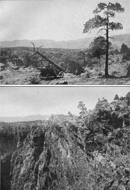
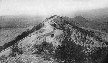
The road first climbs to the top of a steep hogback ridge formed of the sharply tilted Dakota sandstone and then follows the crest of this ridge for several miles. The top of the ridge is so narrow that there is barely room for the road; in fact, the road in many places passes beneath great projecting ledges of the sandstone. (See Pl. XXXV.) From this elevated position one can look down on the town and on acres upon acres of orchards to the east and in the other direction into the valley that separates the hogback from the main mountain. The road finally crosses this valley, climbs gradually to a high plateau, about 1,200 feet above the town, and suddenly comes to the very brink of the Royal Gorge, as shown in Plate XXXIV, A. When the traveler finally stands on the edge of this mighty chasm (Pl. XXXIV, B) and gazes down more than a thousand feet to the raging torrent that rushes through its shadowy depths or to the thundering train that wakes the sleeping echoes from all its cavernous recesses he can but feel that, though the Royal Gorge may not be so deep nor display so great a variety of colors as the Grand Canyon of the Colorado, it has a massiveness of wall and a steepness and ruggedness that can not be matched even by that "Titan of chasms." The canyon gives one the impression that Arkansas River has here acted like a gigantic saw and that what one sees to-day is the deep, narrow cut it has thus made. The canyon seems no wider than the stream that carved it. In places the walls overhang, and one must have steady nerves to stand firmly on the edge and look without dizziness down at a point 1,100 feet below

|
|
PLATE XXXIV. A (top). TOP OF THE ROYAL GORGE. After traversing
the Skyline Drive the traveler may turn to the west and climb to the
summit of the mountain in which the Royal Gorge is cut, he may be
surprised to find that this mountain is really a plateau and that the
automobile may be driven to the very edge of the gorge. Photograph
furnished by the Denver & Rio Grande western Railroad. B (bottom). RIM OF THE ROYAL GORGE. Who can describe the awful grandeur of the chasm that yawns before the traveler when he reaches the rim of the canyon? The walls are nearly sheer for a depth of 1,100 feet, and the chasm seems so narrow that he almost believes that he could cast a stone across it. The character of the rocky walls is well shown in this picture. Photograph furnished by the Denver & Rio Grande western Railroad. |

|
| PLATE XXXV. SKYLINE DRIVE, CANYON CITY. The famous Skyline Drive follows for several miles the crest of the hogback formed by the Dakota sandstone, which is so narrow that there is barely room for the roadway, and in places the heavy ledges of sandstone project over the passing automobiles. This driveway affords a magnificent view of the orchards and farms about Canon City and the mountains in the distance. Photograph furnished by the Denver & Rio Grande Western Railroad. |
The banding of the granite and the many dikes and veins that cut it, as shown in Plate XXXIV, B, give a variety of attractive color effects. In places the soft layers have worn away until there are deep recesses; in others the massive rock has so well resisted the scouring action of the stream that the walls are vertical or even overhang.
On the whole, the canyon shows impressively what an active stream can do when it is working on highly contorted rocks like gneiss and cutting downward only, with little or no broadening.
The view from the top of the Royal Gorge will well repay one who is interested in the canyon as a scenic feature for the trouble he takes to reach it, and it furnishes the student of geology or physiography an almost ideal example of a newly cut gorge.23
23The Royal Gorge presents to the geologist several interesting aspects that have a bearing on its history, or mode of origin and also on the history of other features in this region. The canyon, as has already been stated, was carved in the rocks by the river that occupies it, but not all rivers, even in mountain regions, have carved so deeply, so some special condition here must have made it capable of producing so immense a gorge. The condition was either an uplift of the land or an increase in the volume of the river, which greatly increased its cutting power, but as there are other evidences of uplift it is safe to assume that the cutting of the Royal Gorge was made possible by a general uplift of the region. A stream that is being uplifted, or rejuvenated, as the geologist would say, begins cutting in its lower course, and the cutting progresses headward, but no matter how the cutting took place, the important fact is that the stream cuts its way slowly but surely into the surface of the land, and thus the bends and meanders that characterized the stream when it was flowing on top of what is now the plateau are perpetuated in the canyon. Cutting has not ceased in this interesting canyon but is still going on. The stream still carries sand and in times of flood great boulders, which scratch and grind the rocks over which it flows. To-day it is able to remove all these fragments of rock and its channel is being deepened, but when its grade becomes so flat that it is unable to carry the sand the cutting will cease and the stream may even fill its bed instead of cutting it deeper.
| <<< Previous | <<< Contents >>> | Next >>> |
bul/707/trip3.htm
Last Updated: 16-Feb-2007