
|
Geological Survey Bulletin 611
Guidebook of the Western United States: Part A |
ITINERARY
The traveler who is interested in the geologic history of this country—a history that reaches back into the dim and misty past, to a time long before Father Hennepin first saw the Falls of St. Anthony and the Mississippi Valley in 1680—will find much to attract his attention about St. Paul and Minneapolis. If he has only a few hours at his disposal he can easily obtain a general view of the valley of the Mississippi and the rocks composing its bluffs from the Robert or Wabasha Street Bridge in St. Paul, both of which are within a few minutes' walk of the Union Station. If he chooses the Wabasha Street Bridge, which in some respects affords a better view, he will see that the Mississippi is flowing in a broad valley from 100 to 200 feet deep. In some places the walls of the valley are composed of solid rock, but in others they are made up of loose material, such as clay, sand, or gravel, which forms either large masses or is spread as a thin coating over the rocky slopes. As the valley has been cut in the hard rock by the river, it is a record of stream carving and of the climatic and geographic conditions under which the carving was done. Not only are the recent events of geologic history recorded in the size and shape of the valley, but the much earlier events in the history of the globe have left a record in the solid rock itself—a record that, when correctly read, tells of the presence of a sea in which limy muds were accumulating or along the shore of which sand was washed back and forth by the waves or drifted into heaps by the wind. Every one is more or less familiar with the history of Minnesota during the last 250 years, or since the white man first visited the region, but few know anything of the far more ancient history recorded in the rocks and in the hills and valleys of the region. It is to this ancient history, dealing with the time before man is supposed to have existed upon the globe, that the reader's attention is now invited.
The bluff upon which the Wabasha Street Bridge rests is composed almost entirely of white sandstone (St. Peter1), which is very, very old, but despite its great age is so soft that it can be crushed in the hand. Streams of water flowing through the rock have carved great underground channels in it, and more recently boys have dug caves in the soft sand along the river front directly below the bridge. Jonathan Carver, in describing his journey to this region in 1766, mentions a large cave in the St. Peter sandstone about 30 miles below the Falls of St. Anthony, a cave called by the Indians the "Dwelling of the Great Spirit." In this cave they held religious ceremonies, and near it they buried their dead. When the sandstone is examined under a magnifying glass it is found to be composed of beautifully white translucent grains of quartz, resembling rock candy except that the fragments are round instead of angular. The even lines of bedding, which can be seen from either of the bridges mentioned, show that the sand must have been laid down in water, but the forms of the individual grains show with equal certainty that the sand before it was washed into the ocean and deposited along the shore was blown about by the wind and perhaps heaped into large dunes, such as are now seen around the head of Lake Michigan south of Chicago.
1The rocks exposed at the surface in the vicinity of St. Paul and those revealed by deep drilling are shown in the table on page 9. The natural order of the formations named in the table, from top to bottom, is shown by the order in which the names are printed. The place of each of the larger units of rock or of time (as Cambrian, Ordovician) in the general geologic column is shown in the table on page 2.
Thickness
in feet.Ordovician: Galena limestone (exposed) 15 Decorah shale (exposed) 60 Platteville limestone (exposed) 30 St. Peter sandstone (exposed) 150 Shakopee dolomite 60 Oneota dolomite 100
415Cambrian: Jordan sandstone 75 St. Lawrence formation 100 Franconia sandstone, Dresbach sandstone, and underlying rocks 500
675Red clastic series (Algonkian?) 1,125 Granite
2,215.
The St. Peter sandstone, on account of its purity, is well adapted to glass making and in many places it is used for that purpose. It extends from St. Paul southward as far as central Arkansas and eastward as far as Detroit, and probably once extended much farther north, but in that direction it has been eroded—worn away by frost, rains, and streams—until all trace of it is lost. On account of its wide distribution and the purity of the materials that compose it, this deposit of sand is one of the most remarkable in the world.
Above this sandstone, if stone it may be called, lies a thin-bedded limestone known as the Platteville, which can be seen at the entrance to the Wabasha Street Bridge and which was formerly used about the "twin cities" for building material. The stone occurs, however, in thin layers and does not stand the weather well, so that very little of it is now used. This limestone contains here and there fossil sea shells, which show clearly that the sandy shore of the St. Peter epoch finally sank and was covered by the sea. The shells of the animals that inhabited this sea sank to the bottom when the animals died and were buried in the limy mud that later became hardened into limestone, which preserved not only the shells but all the beautiful ornamentation on their surfaces.
If the traveler can spend a day or two here instead of a few hours, he may take many pleasant rides by trolley or automobile into the surrounding country to places of historic and scenic interest. Whether his visit is one of business or one of pleasure, he should not fail to see old Fort Snelling and the Falls of Minnehaha. Fort Snelling stands on the green, tree-shaded bluffs that overlook the peaceful valley of the Mississippi, and it is hard to realize that when it was established, only a few years after Zebulon M. Pike made his journey to the source of the Mississippi,1 it was in the heart of the Indian country. It is doubtful if at that time anyone dreamed that near its site would rise such cities as St. Paul and Minneapolis. In the early days Fort Snelling was the starting point of several military expeditions that were sent out to explore the great Northwest.
1Soon after the acquisition from France of Louisiana, which included most of the territory west of Mississippi River, Lieut. Z. M. Pike was commissioned by President Jefferson to explore the new territory and to find the source of the river. When Pike reached the mouth of St. Peter (now Minnesota) River, in 1805, he recognized the strategic importance of the point for military purposes and procured from the Indians title for the Government to the land from the mouth of St. Peter River to and including the Falls of St. Anthony. In his report on the explorations he recommended that a fort be established on the bluff between St. Peter and Mississippi rivers. Nothing came of his recommendation until February 10, 1819, when John C. Calhoun, Secretary of War, ordered the Fifth Infantry, under Col. Henry Leavenworth, to establish headquarters at this place. Col. Leavenworth reached the mouth of St. Peter River on September 24 of the same year, but instead of occupying the bluff recommended by Pike he camped across the river, where the village of Mendota now stands. In 1820 Col. Leavenworth was relieved by Col. Josiah Snelling, who determined to build a permanent post on the spot originally selected by Pike. The corner stone is supposed to have been laid on September 10, 1820, and the post was occupied by the troops in 1822. The fort was originally called St. Anthony, but the name was changed to Snelling at the recommendation of Gen. Winfield Scott, who visited it while on a tour of inspection in 1824. Fort Snelling has been continuously occupied as a military post from 1822 to the present time.
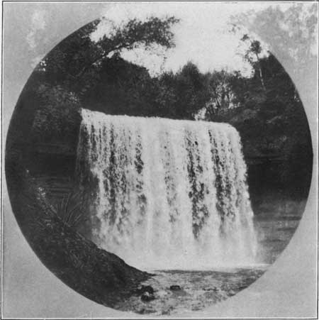
The Falls of Minnehaha, which are about 2-1/2 miles farther north, offer none of the sinister suggestions of war that still linger round the fort; on the contrary, they have an atmosphere of love and romance, and the journey of Hiawatha and Minnehaha, as related by Longfellow, is fittingly commemorated by a bronze group at the head of the falls. (See Pl. II.)
|
| PLATE II.—MINNEHAHA, "LAUGHING WATER." Height of fall, 54 feet. Water tumbles over St. Peter sandstone, which is gradually being cut back toward Lake Minnetonka. Photograph by Haynes, St. Paul, Minn. |
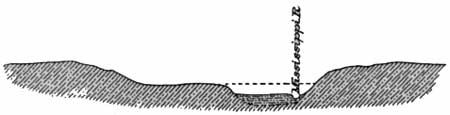
Fort Snelling and the Falls of Minnehaha can be reached from St. Paul by several routes, but whoever wishes to see the rocks and the way they have been carved by the streams should take the Snelling car, which follows the Mississippi upstream for about 6 miles directly to Fort Snelling. The roadway is on a bench or terrace nearly half a mile wide, which stands about 100 feet above the river and on a part of which the business portion of St. Paul has been built. The terrace is underlain by the Platteville limestone, which may be seen at a number of places, and it is evidently a remnant of a valley that existed there before the present channel of the river was excavated in its floor. The accompanying diagram (fig. 1) is a cross section of the valley as it appears to-day. If the channel of the river should be filled to the broken line it would represent the valley floor as it was before the present channel was cut, when the river was flowing at the level of the terrace. As the rocks are not exposed at any place in the bottom of the valley it is evident that the old rock-cut valley has been filled by sediment (alluvium) brought down by the stream, but the depth of this filling has not been accurately determined. A deep well sunk in St. Paul northeast of the Union Station struck solid rock 100 feet below river level. At some remote time the river channel was therefore at least 100 feet deeper than it is now, and since that time it has been filled by mud and sand up to the level of the present river bottom.
|
| FIGURE 1.—Section across Mississippi valley between St. Paul and Fort Snelling, Minn., looking east. The broken line represents the bottom of the valley before the present channel was cut. |
At Fort Snelling the main valley continues to the southwest, but it is occupied only by Minnesota River,1 a stream manifestly too small for the valley in which it is flowing; and, on the other hand, Mississippi River above Fort Snelling is out of proportion to the narrow gorge in which it is confined. To even the most casual observer the streams appear to be misplaced; the larger stream is flowing in the smaller valley and vice versa. The size and relation of the river valleys about St. Paul show clearly that they have undergone many changes which do not occur in streams developing under normal conditions. Changes of this kind have taken place in many of the streams in the northern part of the United States. They are due to the invasion of this country at various epochs in the past by great glaciers which filled existing valleys with the mud, sand, and gravel that they brought in from the north. (See footnote on pp. 26-30.) When the ice vanished the streams found different courses, developing lakes and falls, features characteristic of a newly established drainage system.
1Featherstonhaugh says that the Indian name of this river was Minnay Sotor, meaning turbid waters. By the early white settlers the name St. Peter was applied to it; but later the Indian name was revived, with the spelling Minnesota.
Thus the original drainage about St. Paul consisted of a stream flowing southeastward through the city and following the present course of Mississippi River to a point 10 or 12 miles below St. Paul, where it was joined by a large stream from the west, which crossed the present river valley 4 or 5 miles above Fort Snelling. At that time there was no stream flowing from Fort Snelling to St. Paul. This area was then a rocky upland.
When the western ice sheet (see route map, sheet 1, p. 20) melted back from this region, all these old stream channels were filled with glacial materials, and the principal streams were developed along their present courses. After a time the glacier, which came from the north or northwest, melted back into the Red River valley, and Lake Agassiz (ag'a-see) came into existence. (See footnote on p. 32.) Warren River, the outlet of this large body of water, occupied the present valley of Minnesota River and received Mississippi River as a tributary from the north. This great river flowed across the rocky upland between Fort Snelling and St. Paul and cut a broad valley, upon the floor of which St. Paul has been built. Where it joined the old valley, at the site of St. Paul, there was a waterfall many times the size of St. Anthony. This fall gradually receded upstream until it reached the other old valley above Fort Snelling, and thus the inner rock gorge shown in the diagram was cut.
The gorge of the Mississippi from Fort Snelling to the Falls of St. Anthony, which are a short distance below the station in Minneapolis, shows from its extreme narrowness that it is new and that it has only recently been carved out of the solid rock by the swiftly flowing stream.1 in fact, the process of carving the gorge of the Mississippi is still in operation, or was before it was arrested by the hand of man. Rivers always deepen their channels toward the head of the stream, and the Falls of St. Anthony have doubtless receded slowly from a point near the edge of the main valley at Fort Snelling to their present position. As the rate of recession of this fall has apparently been fairly uniform, and as the distance which the fall has retreated is well known, it has been used in making estimates of the time that has elapsed since the river first started to cut its gorge near Fort Snelling. According to the best estimate, the fall has been 12,000 years in traveling from the vicinity of Fort Snelling to its present position, and it has been 8,000 years since glacial Warren River ceased to flow and the present river system came into existence.
1Many take it for granted that the surface features of the earth have always been the same as they are to-day, that the valleys have always been valleys and the hills and mountains always eminences overlooking them. The incorrectness of such an assumption, however, can be realized by watching any small stream or rill after or during a rain. It will be seen that the stream is busily engaged in cutting the sand or clay over which it flows and carrying it down the valley to be dropped where the current slackens in some pond or lake. Every fragment, as it is loosened from the bed of the stream, is carried or rolled along by the water a few inches or a few feet and then dropped, because the stream is unable to move it farther, as a tired man lays down his burden a moment to rest. By dropping many grains the power of the water is restored and the grain of sand is again picked up, as the man recovers strength and resumes his burden, and is carried or rolled along for a short distance farther. This operation is repeated many, many times, until the grain of sand is finally transported to the sea and finds a resting place upon its sandy shore.
The method by which a stream cuts hard rocks is not so obvious as that by which it cuts sand and clay. The cutting is not done by the water itself, for water alone has no cutting power. The grains of sand and the pebbles that are swept along by the current act as a great rasp, scouring and cutting the hard rocks over which they are carried. Thus grain by grain the rocks are worn away and grain by grain the material is carried to the sea. The process, though slow, never stops; and in time it carves such gorges as that of the Mississippi and even the deeper canyons found in the western mountains.
When the receding Falls of St. Anthony reached and passed the mouth of Minnehaha Creek that stream plunged into the deepened gorge and the Falls of Minnehaha originated. Since that time they have been worn back about 400 feet to their present position. Each day some particle of rock is dislodged or worn away, and gradually the falls are working back up the stream. In the course of time they will reach Lake Minnetonka, and then this beautiful sheet of water will be drained, but that catastrophe will occur so far in the future that the owners of the hotels and summer cottages that line its shore need not be alarmed.
Lake Minnetonka is also the direct result of the occupation of the country by the ice, as are the 10,000 other lakes which Minnesota is reported to contain. Their mode of origin, which is extremely interesting, will be discussed in connection with a description of the many other lakes that will come into the traveler's view as he continues his westward journey. Lake Minnetonka is easily reached by trolley from both St. Paul and Minneapolis, and an afternoon or evening spent along its beautiful shores makes a most acceptable break in a long transcontinental journey. White Bear Lake, about 6 miles north of St. Paul, bears the same relation to that city as a summer resort that Lake Minnetonka bears to Minneapolis.
The site of the present city of St. Paul is said to have been a favorite gathering ground for the Sioux Indians long before white men invaded their hunting grounds, and it is probable that for many generations Indian villages stood within what are now the city limits. When the white men came they located at Mendota, on the south side of Mississippi River near the mouth of the Minnesota, and this was the first settlement in the State. What is now the city of St. Paul was settled more recently, and its origin and the manner in which it received its name are interesting events in the history of this region.1
1When the military post of Fort Snelling was established, in 1820, the boundaries of the reservation had not been determined and consequently the post was overrun with all sorts of camp followers. In 1839 the limits of the reservation were fixed and efforts were made to eliminate the undesirable element, but not until May 6, 1840, were the troops successful in evicting all the roughs and in demolishing their cabins. The evicted persons crossed the river and started a hamlet near the spot where the Union Station at St. Paul now stands. This was soon graced by a Roman Catholic chapel called St. Paul's, which gave its name to the village. From such inauspicious beginnings the city has developed.
| <<< Previous | <<< Contents >>> | Next >>> |
bul/611/sec.htm
Last Updated: 28-Mar-2006