
|
Geological Survey Bulletin 1991
Late Quaternary Faulting Along the Death Valley-Furnace Creek Fault System, California and Nevada |
INTRODUCTION
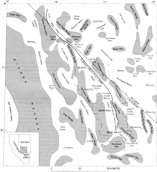
The Death Valley—Furnace Creek fault system of eastern California and western Nevada (fig. 1) is an active tectonic structure of regional significance that has had a profound influence on the geologic and geomorphic development of the western Great Basin. This fault system, more than 300 km (kilometers) in length, is the second longest fault system in California, surpassed in length only by the San Andreas fault system, and shows abundant geologic and geomorphic evidence of youthful surface rupture. However, no large historic earthquakes are known to be associated with faults in the system (Real and others, 1978; Ryall and others, 1966). All fault-related features, with one possible exception, are interpreted as prehistoric, although presently ongoing aseismic creep may be occurring in places (Burford and Harsh, 1980; Sylvester and Bies, 1986). For this reason, a scarp- or lineament-producing faulting event may be due to either an earthquake or a period of aseismic fault creep.
|
| Figure 1. Map of the region surrounding the Death Valley—Furnace Creek fault system, showing major geographic features and trace of major faulting along fault system. (click on image for a PDF version) |
Movement along other faults in nearby areas has produced large earthquakes during historic time (Jennings and others, 1975; Ryall and others, 1966), and many of those faults have youthful fault-related features that are similar to features along the Death Valley—Furnace Creek fault system (Slemmons, 1967; Jennings and others, 1975). Examples include the 1872 Owens Valley earthquake, focused about 95 km west of Death Valley, and the 1932 Cedar Mountain earthquake, about 50 km north of Fish Lake Valley. As recently as 1986 in Chalfant Valley along the White Mountains, almost 25 km west of Fish Lake Valley, centimeter-scale scarps and cracks of tectonic origin formed during a moderate earthquake (dePolo, 1989). Accordingly, the Death Valley—Furnace Creek fault system is considered active and is a potential source of large earthquakes. The chronology of geologically recent faulting discussed in this report is therefore a useful background for assessing contemporary seismicity patterns and recurrence periods for large earthquakes on the fault system.
The Death Valley—Furnace Creek fault system may be viewed as part of a large, currently active, northwest-directed pull-apart zone, such that movement along the Furnace Creek fault zone is mostly strike slip and that along the north-trending Death Valley fault zone is mostly normal slip (Burchfiel and Stewart, 1966; Stewart, 1983). Estimates of right-lateral displacement along the Furnace Creek fault zone range between 40 and 100 km, but displacement is probably closer to 80 km (evidence summarized by Stewart, 1983); right-lateral displacement along the Death Valley fault zone was originally reported to be less than 8 km (Wright and Troxel, 1967) but was more recently estimated to be about 35 km (Butler and others, 1988).
The large component of normal offset along the Death Valley fault zone is a recent manifestation of the same general extensional processes that produced the impressive turtleback structures (denuded detachment surfaces on mostly Precambrian rock) in the Black Mountains (for example, Drewes, 1959; Hamilton, 1988). Stewart (1983) suggested that the Panamint Range may have originally resided atop the Black Mountains and subsequently slid 80 km to the northwest to its present location along the detachment (or several detachments) during middle to late Tertiary time. The gap or void created by ongoing extension between the Panamint Range and the Black Mountains is the site of the present Death Valley.
This report describes the Death Valley—Furnace Creek fault system between Wildhorse Flat (pl. 1A) at the north end of Fish Lake Valley, and Shoreline Butte (pl. 4) at the south end of Death Valley. Figure 1 shows the major ranges and valleys near the fault system. Faults along the main fault trace are mapped and described, and some of the faults subsidiary to the main fault system also are mapped. The mapped subsidiary faults include those in northern Fish Lake Valley between Indian and Marble Creeks (pl. 1A), in central Fish Lake Valley north of Oasis (pl. 1A), in the Oriental Wash area (pl. 1B), Ubehebe Crater area (pl. 1C), along the northwest side of Tucki Mountain (pl. 2), and along the west side of Death Valley (pls. 1C, 3, and 4).
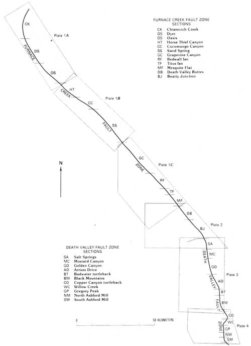
The northwest-trending Furnace Creek fault zone, shown on plates 1 and 2, is the northern part of the Death Valley—Furnace Creek fault system and is subdivided for purposes of discussion into 12 sections (fig. 2). A neotectonic map of the Furnace Creek fault zone within California, based largely on the unpublished mapping of G.E. Brogan (the same data used for this report), was recently compiled (Bryant, 1988). The north-trending Death Valley fault zone, the southern part of the fault system, is subdivided into 11 sections (southernmost part of pl. 2 and pls. 3 and 4).
|
| Figure 2. Reference map of the Death Valley—Furnace Creek fault system, showing the 12 sections of the Furnace Creek fault zone and 11 sections of the Death Valley fault zone. (click on image for a PDF version) |
The term "section" rather than "segment" is used in this report because in the past decade the latter term has acquired a specific meaning in neotectonic studies (for example, Machette and others, 1991). A fault segment refers to a part of a fault zone or system that typically lies adjacent to a coherent or semicoherent block during a faulting event, so it commonly undergoes synchronous movement and has a map pattern that is distinct from that of adjacent fault segments. In this report, the subdivision of the fault system into sections is subjective and is based on changes in (1) trend of faults, (2) recency of faulting as expressed by the preservation of fault-related geomorphic features, (3) width of the fault zone, (4) consistency of fault patterns, and (5) proximity of the most recently active trace to adjacent range fronts and bedrock structures. Sections may, in fact, be segments, but that meaning is not necessarily implied in this report.
Acknowledgments
This report summarizes the principal findings of G.E. Brogan's study of the Death Valley—Furnace Creek fault zone, begun in 1969. He performed all of the original field work, aided by special low-sun-angle aerial photographs taken for this work. On the basis of additional aerial photograph interpretation and limited field work, Kellogg and Terhune verified, revised, and condensed text and map information from the original report. Numerous localities were checked in March 1989 by M.D. Carr, K.F. Fox, Jr., K.S. Kellogg, D.W. Rankin, M.C. Reheis, J.C. Tinsley, and J.C. Yount. Thorough reviews of the manuscript were made by K.F. Fox, Jr., R.A. Thompson, and V.M. Glanzman. This work is part of the Yucca Mountain Program in cooperation with the U.S. Department of Energy (Interagency Agreement DE—A108—78ET44802).
The original investigation by Brogan was suggested by Slemmons of the Mackay School of Mines, University of Nevada at Reno, and was conducted under his overall guidance. Support for the original investigation was provided by the U.S. Atomic Energy Commission, the California Division of Mines and Geology, the National Science Foundation, Mackay School of Mines Foundation, Woodward-Clyde Consultants, and the U.S. Geological Survey. The people who contributed significant time and thought during the course of the original study include W.J. Carr, L.S. Cluff, B.W. Troxel, G.A. Carver, and C.E. Glass.
| <<< Previous | <<< Contents >>> | Next >>> |
bul/1991/intro.htm
Last Updated: 24-Jul-2009