
|
Geological Survey Bulletin 1592
Depositional Environments of the White Rim Sandstone Member of the Permian Cutler Formation, Canyonlands National Park, Utah |
DEPOSITIONAL SETTING
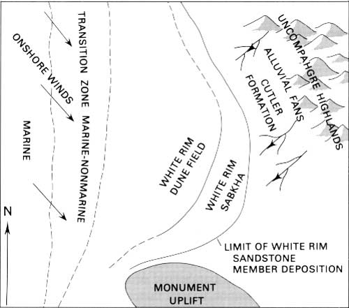
Figure 23 is a schematic diagram of the depositional setting of the White Rim Sandstone Member. Dune fields can be broadly grouped as either coastal or inland (McKee and Bigarella, 1979b). Several different lines of evidence suggest the White Rim Sandstone Member was deposited in a coastal setting. These are (1) Permian paleogeography, (2) stratigraphic relationships, (3) geometry of the White Rim sand body, (4) dune form, and (5) certain petrologic features.
|
| Figure 23. Schematic diagram of White Rim Sandstone Member depositional setting. |
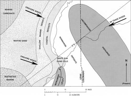
The White Rim Sandstone Member was deposited during late Leonardian to early Guadalupian time according to Baars and Seager, (1970). Figure 24 shows the proposed Early Permian paleogeography of Canyonlands and surrounding areas. West of Canyonlands was a broad, stable shelf, and to the east, the positive Uncompahgre highlands and Monument upwarp. The shoreline was to the west, running approximately north-south, and Canyonlands was situated in an active coastal plain area exposed to both marine and nonmarine processes. The proposed paleomagnetic equator during the Permian was to the north. Canyonlands was at approximately 5° S. latitude, and much of North America was in the Southeast Trade Winds Belt (Opdyke and Runcorn, 1960; Dott and Batten, 1976). Northwest to southeast winds deposited the White Rim sand even though the area was in the Southeast Trade Wind Belt. This northwest to southeast wind pattern may represent onshore winds, resulting from differential cooling and warming between land and sea. According to Goldsmith (1978), an onshore wind pattern commonly is dominant regardless of the general wind circulation pattern. Also, this southerly wind pattern was common in the Permian and is evident in other proposed eolian units in the region, including the DeChelly Sandstone Member of the Cutler Formation and the Coconino Sandstone (Poole, 1962).
|
| Figure 24. Paleogeographic map of Canyonlands National Park and surrounding area: late Wolfcampian—early Leonardian time. (Modified from Hallgarth, 1967b) (click on image for a PDF version) |
Stratigraphic relationships of the White Rim imply a coastal setting. It abruptly pinches out eastward into the nonmarine Organ Rock Member. Westward it apparently grades into the largely marine upper member of the Toroweap Formation and the gamma member of the Kaibab Limestone. Unfortunately, much of the westernmost White Rim occurs in the subsurface, and little information is available. The transition between marine and eolian environments may begin just west of Canyonlands, in the Elaterite Basin area (fig. 1), where the uppermost portion of the White Rim contains a thin, veneer-like unit with well-developed but localized oscillation ripples (Baars and Seager, 1970; Chan and Huntoon, 1984). Chan and Huntoon (1984) observed coarse-grained sandstones with chert pebbles and abundant fluid escape structures in this uppermost unit and considered it to represent a reworked zone, formed during a marine transgression. Also, northwest of the study area near the San Rafael uplift (fig. 1), the top of a unit identified as White Rim is bioturbated and contains identifiable marine fossils (Orgill, 1971).
The geometry of dune sands is probably closely related to their depositional setting (McKee and Bigarella, 1979b). An inland dune field tends to form an extensive, tabular or wedge-shaped sand sheet. A coastal dune field can form a more narrow, elongate sand sheet. The White Rim, an elongate, narrow, northwest-southeast sand body, is more characteristic of a coastal dune field. Unimodal crossbedding measurements indicate the White Rim dune form was most likely barchanoid or transverse ridges (fig. 8), which are common coastal dune forms in unvegetated areas (Goldsmith, 1978).
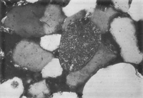
Coastal dune sands are essentially beach sediments that have been reworked and piled up by the wind. Several petrologic features of the White Rim suggest the proximity of a beach, the most important of which is the presence of glauconite. Trace amounts of well-rounded, unaltered glauconite pellets (fig. 25) were observed in thin sections of samples collected from all the measured sections, and occur in both dune and interdune deposits. Glauconite is the name given to a variety of dull-green, earthy, iron-rich clay minerals of the mica group that commonly form under local reducing conditions in shallow-marine water (Weaver and Pollard, 1973). The presence of glauconite in a sediment usually indicates a marine depositional environment, for it rarely survives erosion and redeposition in nonmarine environments (Triplehorn, 1966). The occurrence of glauconite throughout the White Rim suggests proximity to a marine environment. Along with the glauconite, the crinoid fragment and the relative enrichment of heavy minerals in the interdune deposits may also indicate a nearby beach. According to Potter (1967), skeletal debris, heavy mineral concentrates, and small amounts of glauconite are common constituents of many beach sediments.
|
| Figure 25. Glauconite pellet (G), dune deposit, Beaver Bottom section. (Field of view approximately 0.7 mm, polars crossed) |
| <<< Previous | <<< Contents >>> | Next >>> |
bul/1592/sec3.htm
Last Updated: 09-Nov-2009