
|
Geological Survey Bulletin 1508
The Geologic Story of Colorado National Monument |
TRIPS THROUGH AND AROUND THE MONUMENT29
29In the following sections the small numbered triangles in the right margin refer to key points along the trip routes. Figure 3 shows the locations of these key points. These numbers should be especially helpful if the reader happens to follow the road guides in reverse.
From Grand Junction through the Badlands to the West Entrance of the Monument
| 1 STARTING POINT |
WE WILL BEGIN OUR TRIP in the southwestern part of Grand Junction at the intersection of First Street and Grand Avenue, (this is also the intersection of U.S. Highways 6 and 50 and Colorado Highway 340), by following a sign on Highway 340 pointing westward toward the Monument. After crossing a viaduct over the railroad yards and a bridge across the Colorado River, we come to a traffic light and a sign pointing left toward the Monument. The road to the left connects with Monument Road which leads up No Thoroughfare Canyon to the East Entrance. However, we will continue westward toward The Redlands. | ||||
| 2 REDLANDS CANAL |
Just beyond the stoplight we cross a bridge over the Redlands Power Canal which carries 675 cubic feet per second (cfs, or ft3s-1)30 from the Redlands Diversion Dam on the Gunnison River about 2-1/2 miles south of Grand Junction. A quarter of a mile northwest of the bridge, most of the water falls to a lower powerplant that generates electricity for pumping the remaining 50 cfs to three lift canals, which are used mainly for irrigating peach orchards in the eastern part of The Redlands.
| ||||
| 3 SOUTH BROADWAY |
After Colorado Highway 340 curves right it is known as Broadway—a paved road serving much of The Redlands and connecting with the West Entrance of the Monument. We will follow Broadway about 3 miles, passing low outcrops and roadcuts of the Dakota Sandstone, some of which contain coal beds and some of which are covered by a veneer of gravel laid down by the river when the channel was higher. Then, at the first store and filling station we turn southwest on another paved road known as South Broadway. | ||||
| 4 SOUTH CAMP ROAD SIDE TRIP |
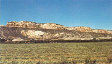
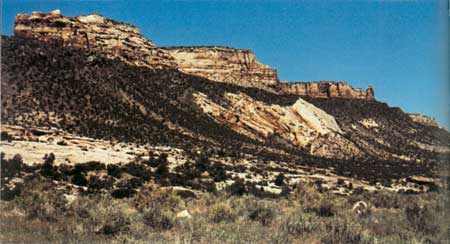
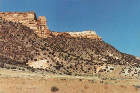
Just around the curve to the right is a T-intersection from which paved South Camp Road leads south to a growing suburban area; and 2-1/2 miles to the southeast it connects with Monument Road at a point only half a mile north of the East Entrance of the Monument. Excellent views of the cliffs of dark Proterozoic rocks, the overlying cliffs of the Wingate Sandstone, and the Redlands fault along the northeastern border of the Monument are seen all along South Broadway, but views from South Camp Road and several connecting roads to the southwest are especially good. (See figs. 37 and 38.) As noted earlier, the Redlands fault has a maximum vertical displacement of 700 or 800 feet, but dies out in scissors fashion at each end.
| ||||
| 5 BRACHIOSAURUS MONUMENT |
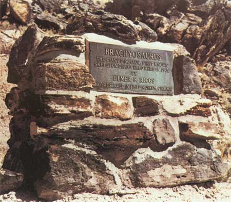
As we continue westward on South Broadway, note on right the brightly colored mudstone and siltstone of the Brushy Basin Member of the Morrison Formation strewn with large blocks of rusty-looking sandstone from the Burro Canyon Formation, which caps the high ridge on the right. Just above the deep cut on the right four-tenths of a mile west of the intersection with South Camp Road is a bronze plaque set in a masonry monument, whose lettering is easily readable in figure 39. Many years after the excavation in 1900 (fig. 22), Elmer Riggs contacted Al Look, of Grand Junction, in regard to the casting and erection of this plaque. Al, Elmer, Ed Faber, and a few other citizens put up the necessary funds and personally erected the plaque and monument. Somehow or other, Brachiosaurus was misspelled Brachyosaurus, as shown in figure 39, but the intentions were good. Later I will call attention to another similar monument commemorating the finding by Riggs of another dinosaur skeleton.
| ||||
| WATCH TURNS |
After a sharp turn to the north and another to the west, South Broadway reaches the top of a hill just above the Elk's Club and curves gently to the right past sandstone lenses in the Salt Wash Member of the Morrison Formation. A 610-foot-deep well at the house on the left formerly flowed about 1-1/2 gallons a minute from the Entrada and Wingate Sandstones. | ||||
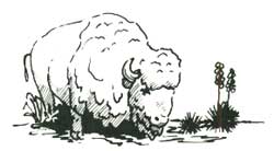
| 6 LEFT TURN WATCH FOR BUFFALO |
Half a mile to the north, South Broadway turns sharply to the left even though another paved road continues northward. Three-fourths of a mile to the west, we turn northwestward parallel to the Monument boundary fence for seven-tenths of a mile before turning north again. The 7-foot chain-link fence just to the left of the road is the northeastern boundary of the Monument and encloses the herd of buffalo. In the late forties or early fifties a young bull challenged the older leader for possession of the herd and gored and pounded the old bull so badly he had to be shot by a ranger. During the furious battle 125 feet of this strong steel fence was utterly demolished. It is reported that sometimes an old bull simply takes one look at the young challenger and retreats without a battle, but other lone or rogue bulls may temporarily or permanently leave the herd for other reasons. Such outcasts are dangerous and unpredictable. One bull kept a ranger "treed" for 4 hours on a steep rock ledge in the broiling sun before moving on to a patch of grass. Four of these critters delayed by one week my walking out a stretch of the Redlands fault on their side of the fence. I decided that a live geologist had advantages over a dead hero. | ||||
| REDLANDS FAULT 7 WINGATE DRIVE SIDE TRIP |
Throughout most of its 6-mile length the Redlands fault is a vertical or nearly vertical normal fault, but along and near this 0.7-mile stretch it is a reverse fault that dips from 45° to 60° to the southwest, as shown in figure 40 and in the cross section of figure 8. Good views of the fault are seen all along the fence, but especially at points one-tenth and four-tenths of a mile northwest of the first turn, the second of which is shown in figure 40. Just after turning north on South Broadway, let us turn west a few hundred feet on paved Wingate Drive to see the northwest end of the Redlands fault, which passes through a col to the left of updragged remnants of the thinned red Chinle Formation and the Wingate Sandstone, as shown in figure 41.
| ||||
| MONUMENT CANYON TRAIL |
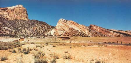
About half a mile north of the last turn, South Broadway rejoins Broadway (Colo. Highway 340) at a stop sign. After we turn left on Broadway and reach the first curve, we get a nice view westward into Monument Canyon, as shown in figure 42. The Park Service hopes to establish a new trailhead at the bridge one-tenth of a mile west of the curve, from which a new section of trail will follow the normally dry wash southwestward to join the old Monument Canyon Trail. After we cross the creek leaving the canyon, we pass a low hill of the Salt Wash Member of the Morrison Formation on the left. Just beyond the hill, the dirt road leading southwest to a farmhouse formerly was the beginning of the Monument Canyon Trail (fig. 3). There is a new temporary trailhead a quarter of a mile north, but it is hoped that a permanent one can be built at the bridge about a quarter of a mile to the southeast, as noted above. Hikers may see buffalo along this trail and should watch out for outcast bulls.
| ||||
| 8 DRAINAGE DIVIDE |
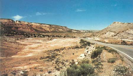
About half a mile north of the farm road we reach the highest point on Broadway (Colo. 340) at a drainage divide. Inasmuch as the three Redlands Lift Canals end east of the divide, there is quite a contrast between the lush irrigated lands east of the divide and the nearly barren desert to the west, a view of which is shown in figure 43. To the southwest of the divide is an excellent view of the northeastward-dipping beds on the Lizard Canyon monocline. On the left about a mile northwest of the divide we pass the other entrance of Monument Canyon, then Lizard Canyon, and a switchback on Rim Rock Drive ascending the ridge between Lizard and Fruita Canyons. The water well beneath elevated tank on left is 650 feet deep and formerly flowed at about half a gallon a minute from the Wingate Sandstone. Household needs are obtained by pumping.
| ||||
| ROAD INTERSECTION |
At the next intersection, Colorado Highway 340 turns right and continues about 2-1/2 miles to Fruita; the highway to the left reaches the West Entrance of the Monument in a quarter of a mile. Before turning left into the Monument, however, we will interrupt our description of the trip by making a new start from Fruita for the benefit of people travelling from this direction.
|
| <<< Previous | <<< Contents >>> | Next >>> |
bul/1508/sec12.htm
Last Updated: 8-Jan-2007