
|
Geological Survey Bulletin 1286
Gold Veins Near Great Falls, Maryland |
DISCOVERY AND DEVELOPMENT
The most authoritative account of the discovery of gold near Great Falls is that by Ingalls (1960). He states that the discovery was made in 1861 near the present site of the Maryland mine (pl. 2) by Private Cleary, a member of a regiment of California volunteers under the command of Col. Edward A. Baker which was camped in the area to guard against a Confederate attack across the Potomac following the first Battle of Bull Run. Shosteck (1953) gives the discoverer's name as John Clear and the date of discovery as 1864.
There is no record of any California units in the Eastern Theater during the Civil War. In the spring of 1861, however, Edward Baker, then Senator from Oregon and a close personal friend of President Lincoln, was commissioned colonel and authorized to recruit three regiments of infantry in Philadelphia. One of these, the 71st Pennsylvania, was placed under his command and was informally referred to as the "1st California," apparently in honor of Baker and several of his officers who had come from the west coast (Banes, 1876). The 71st Pennsylvania camped near Great Falls on the night of September 30, 1861, on a march from Chain Bridge to Rockville, Md. From October 3 to 20 the regiment was camped at Poolesville, about 15 miles to the northwest, and it is possible that small detachments remained in the Great Falls area during part of that time. Colonel Baker was killed in action at the Battle of Balls Bluff on October 21, where the regiment was heavily engaged. Following this action, the regiment was assigned to picket duty along the Potomac, where it remained during most of the winter (Banes, 1876).
No Private Cleary or Clear appears on the roster of the 71st Pennsylvania (Bales, 1869), but the rolls carry the names of Alexander McCleary, private, Company C, and John Carey, private Company K. Private McCleary enlisted at Philadelphia on May 21, 1861, and was discharged on a surgeon's certificate on April 5, 1862; Private Carey enlisted at Philadelphia on June 28, 1861, and was discharged for wounds received at Antietam on September 17, 1862. Both of these men were apparently with the regiment when it was near Great Falls, and it is reasonable to assume that one or the other of them made the gold discovery.
Following his discharge, Private McCleary (or Carey) organized a group that bought the farm on which the original discovery was made (Ingalls, 1960). Considerable prospecting and developing work were done, and in 1867 a shaft was sunk to a depth of about 100 feet at the future site of the Maryland mine (pl. 2; fig. 4). Mint records (fig. 3) show that at least 7 ounces of gold were produced in 1868 and 4 ounces in 1869, but much of the early production may never have reached the mint. At any rate, the work was soon abandoned.

|
| FIGURE 3.—Graph showing production of gold in Maryland from 1868 to 1951. Stipple indicates production from the Great Falls vein system. For locations of mines outside Great Falls area, see figure 1. (click on image for an enlargement in a new window) |
Sometime in the 1880's, gold was discovered in the vicinity of the Ford mine (pl. 2) by George Kirk, a Georgia prospector. By the time of Emmons' visit in February 1890, the veins were being worked by extensive opencuts on both sides of Cool Spring Branch, and a small mill was in operation near the mouth of the branch. At that time the tract was known as the Allerton-Ream property. There is no record of the production from those workings, but certainly part of the total Maryland production between 1880 and 1891 must have been from that source. Underground development at the Ford mine probably began about 1890, but there is no record of its progress.
In 1903 or 1904, considerable prospecting and development work were done on the veins along Carroll Branch, between the Maryland mine and the Allerton-Ream property. That area, which includes the site of the Watson mine (pl. 2), was known as the Anderson property and was operated by the Great Falls Gold Mining Co. The veins and workings were described by Weed (1905); he discussed seven named veins, but the only one that can be specifically identified from his descriptions is the Potomac vein (pl. 2). According to Weed, this vein was explored by a 135-foot adit north of MacArthur Boulevard. The dump and caved portal of this tunnel are still visible from the road, about 100 yards east of the entrance to the parking lot at Great Falls Park. The other six veins Weed described are probably those that cross Carroll Branch north and northwest of the site of the Watson mine (pl. 2). The workings in that area consisted of many pits and trenches and a few shallow shafts with short drifts and crosscuts. The operations continued until at least 1909.
About 1900 the property subsequently known as the Maryland mine was taken over by the Maryland Gold Mining Co. A 135-foot shaft (fig. 4, No. 1 shaft) was sunk, and the vein was explored by drifts on the 50- and 100-foot levels (Ingalls, 1960). On the 100-foot level the vein was followed for about 100 feet in each direction from the shaft (Weed, 1905). In 1903 a new shaft (fig 4, No. 2 shaft) was started west of the vein and 60 feet south of the old shaft. It was intended to cut the vein at a depth of 500 feet, but, instead, intersected it at 200 feet and was bottomed at 210 feet in 1906. The mine was shut down in 1908. In 1912 the mine was reopened briefly by the Empress Gold Mining Co. of Philadelphia and some development work was done on the 135-foot level, but the company's option was not renewed.
|
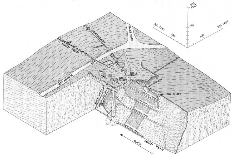
| FIGURE 4.—Isometric block diagram of the Maryland mine. Surface details shown as they appeared in 1967. Underground workings as they appeared in 1940, at the time the mine was closed; sketched from recollections by E. T. Ingalls, underground foreman from 1986 to 1940. The block has been cut away to expose the surface of the main (Maryland) vein south of the No. 2 shaft and the surface of the northeast split north of the shaft. Vein stippled where predominantly quartz and coarsely lined where quartz is absent. Finely lined areas are stopes from which ore has been removed. (click on image for an enlargement in a new window) |
The most systematic exploration of the Great Falls veins began in 1915 when the Atlantic Development Co. acquired the Ford mine. By 1918 the company had acquired tracts totaling 2,100 acres that included nearly all the known vein system. A. A. Hassan, a mining geologist and consulting engineer, directed an exploration program that included extensive trenching, vein stripping, and diamond drilling. The long east-west cross trenches (fig. 2; pl. 2) and most trenches and pits along the veins date from that period. No complete record of the results of the diamond drilling remains, but Ingalls (1960) reports that a drill hole 1,000 feet north of the Maryland mine proved the vein to a depth of 456 feet, and that holes near the Ford mine showed that the veins extend to a depth of at least 500 feet. Some underground development work was done in the Ford and Maryland mines, but no production was recorded. The assay laboratory at the Ford mine (fig. 5A) was probably built during that period.
|
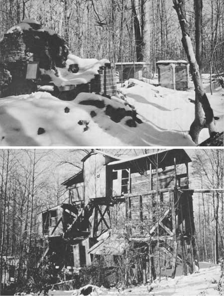
| FIGURE 5.—Ruins of assay laboratory and mill. A (top), Ruins of assay laboratory at the Ford mine, about 100 feet east of No. 2 shaft. Brick structure in foreground was the furnace; cement tables in the background held analytical balances used for precise weighing. B (bottom), Ruins of mill at the Maryland mine. Ore cars entered on trestle at (a), and dumped into ore bin (b). Ore was fed into primary jaw crusher located on concrete foundation at (c), where the ore was crushed to fragments about 3 inches in diameter. It was then hoisted by bucket elevator to a second jaw crusher (d). From there, the ore passed through a 10-stamp mill (e) and ball mill (f). Finely crushed ore then passed through an impact amalgamator where free gold combined with mercury; it then passed over concentrating tables where gold-bearing sulfide minerals were recovered. |
An interesting sidelight on the operations is related by E. T. Ingalls and T. B. Nolan (oral commun., 1966). They report that the extensive trenching under Hassan's direction aroused considerable suspicion and gave rise to newspaper reports that entrenchments were being prepared for a German attack on Washington! As a result of the allegations, H. G. Ferguson, of the U.S. Geological Survey, was dispatched to examine the operations. Unfortunately, no copy of his confidential report can be located, but apparently he was able to certify that Mr. Hassan was indeed searching for gold and had no ulterior motive.
In the fall of 1917 the surface exploration program was abandoned and the mines were closed down, but the Maryland mine was reopened in the spring of 1918. Development work was done on the 135- and 200-foot levels between 1918 and 1921 and some ore was mined; but as no mill was in operation, the ore was stockpiled and no production was recorded. The mine was closed, and the entire property was sold in 1922.
No further exploration or mining was done on the Great Falls vein system until after the price of gold was increased to $35 an ounce in 1934. Stimulated by the higher price of gold, the Maryland Mining Co. was organized in October 1935; the Maryland mine was opened again, and a new mill was installed (fig. 5B). Between 1936 and 1940 about 6,000 tons of ore were produced, principally from stopes on the 135- and 200-foot levels, and more than 2,500 ounces of gold, valued at $90,000, were recovered (fig. 3). The mine was closed in 1940.
The Ford mine is reported to have been worked briefly as late as 1940, but no production was reported and there is no record of the developments.
Since 1940 the mines have remained closed. Spare-time prospecting by E. T. Ingalls and his son Huntley yielded 20 ounces of gold in 1950 and 1 ounce in 1951. Since 1951 there has been no recorded production.
Lines in country rock on vertical faces of block are diagrammatic traces of foliation and bedding in schist and graywacke. Pattern of coarse angular dots on block faces near No. 2 shaft indicates dump material. Circular structure north of No. 2 shaft is the foundation of a 25,000-gallon water tank. The building to the north was the blacksmith shop. The rectangle west of No. 2 shaft is the foundation of the hoist house; the rectangle north of No. 1 shaft is the foundation of the mine office and assay laboratory. The ruin of the mill (fig. 5) lies about 200 feet southwest of No. 2 shaft on the part of the block that has been removed. From Reed and Reed, 1967, figure 3.
| <<< Previous | <<< Contents >>> | Next >>> |
bul/1286/sec1.htm
Last Updated: 28-Mar-2006