
|
Geological Survey Bulletin 1191
Black Canyon of the Gunnison: Today and Yesterday |
PHYSIOGRAPHIC SETTING
The Black Canyon of the Gunnison lies in a transition zone between two physiographic1 provinces—the Southern Rocky Mountains on the east and the Colorado Plateaus on the west. In this area the boundary between the two is ill-defined. The entire Black Canyon area has attributes of both provinces and could be assigned to either.
1See glossary, p. 70, for a description of semitechnical terms.
For a better understanding of the physical and spatial relations of the Black Canyon, topographic maps are an invaluable aid. Fortunately, excellent coverage is available. Regional topographic relations are well portrayed on the 1:250,000-scale (4 miles per inch) Montrose topographic sheet prepared by the Army Map Service and published in civil edition by the U.S. Geological Survey. This map covers the area between Montrose on the west, Salida on the east, Grand Mesa on the north, and Ouray on the south. It shows unusually well the relation of the Gunnison River system to the West Elk, Sawatch, and San Juan Mountains and the extraordinary setting of the Black Canyon across the Gunnison uplift.
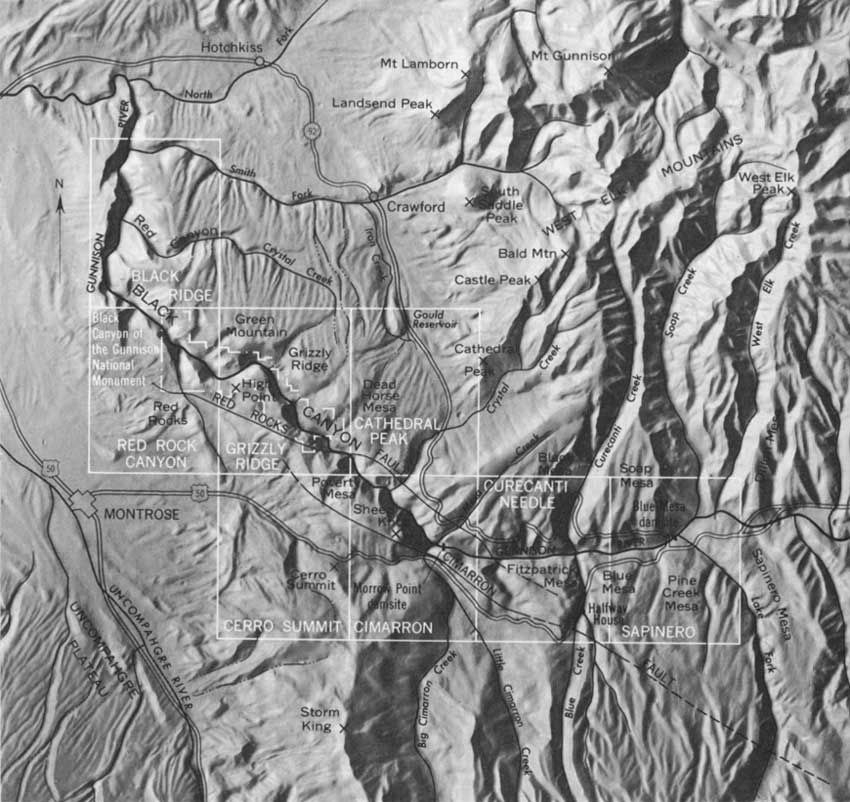
At a larger scale and in greater detail, the Black Canyon is covered by seven topographic quadrangle maps recently published by the Geological Survey at a scale of 1:24,000 (2,000 feet per inch). These maps shows roads, trails, other cultural features, streams, lakes, and woodland areas, besides showing in detail the contour of the canyon walls and adjacent areas. They also identify most of the important named landmarks referred to in this report. Most of the national monument—all the more accessible part—lies within the Grizzly Ridge quadrangle. The remainder is in the Red Rock Canyon quadrangle. The index map (fig. 2) shows the topographic map coverage of the Black Canyon area.
High Point, at the end of the South Rim Drive in the Black Canyon of the Gunnison National Monument, provides a good bird's-eye view of regional physiographic relations. High Point is near the topographic and structural crest of the Gunnison uplift, an elevated part of the earth's crust through which the Gunnison has cut its canyon. From High Point the view is unobstructed in all directions. Looking northeast across the canyon, one sees the isolated laccolithic peaks and volcanic mesas of the West Elk Mountains. These mountains much resemble other laccolithic groups on the Colorado Plateaus, but they are closely tied to the Rocky Mountains topographically, and they are included in the Southern Rocky Mountains by most physiographers. Their western front is taken as the boundary of the Southern Rocky Mountain province.
|
| FIGURE 2.—The Black Canyon area. (click on image for an enlargement in a new window) |
Turning clockwise and looking south beyond the ridges and mesas that rim the Black Canyon, one sees on the horizon the lofty snow-flecked summits of the San Juan Mountains, an impressive westward-trending bulwark of the Southern Rocky Mountains, dominated by Uncompahgre Peak at the far left, Mount Sneffels near the center, and Lone Cone at the far right. These mountains contain rocks of many types and of nearly all ages.
To the southwest and 2,500 feet below High Point in the bottom of the Uncompahgre Valley is Montrose, a marketing center for the livestock and lumbering industries and for the extensive agricultural enterprises of the valley. The Uncompahgre Valley and forest-topped Uncompahgre Plateau on the skyline beyond are units of the Colorado Plateaus province.
Northwest of High Point, and almost directly below, are the lower reaches of the Black Canyon. Near the canyon mouth the North Fork joins the main stem of the Gunnison River; a few miles farther downstream, the Uncompahgre River joins also. Though not visible from High Point, the main stem continues northwestward in the broad valley between the Uncompahgre Plateau to the left and the Grand Mesa on the skyline to the right. Topographically and structurally, this valley is a northward-trending continuation of the Uncompahgre Valley. Lava-capped Grand Mesa, standing nearly a mile above the Gunnison River valley, is also a unit of the Colorado Plateaus.
For a synoptic view of the canyon itself, the south rim of Fruitland Mesa is an unsurpassed vantage point. Unfortunately, this rim is accessible only by way of trails and a primitive road. Looking south from the rim of the mesa, one gains an otherwise unobtainable appreciation of the setting of the canyon in its immediate surroundings and a positive impression of the relation of the canyon to late Tertiary and Quaternary physiographic events.
| <<< Previous | <<< Contents >>> | Next >>> |
bul/1191/sec1.htm
Last Updated: 28-Mar-2006