|
FORT VANCOUVER
Master Plan |

|
THE PLAN
The historical importance of Fort Vancouver and its location in an urban environment close to a major interstate tourist route presents the opportunity to reveal to a large number of people, through extensive reconstruction, restoration, and interpretation, the significant story of early settlement in the Northwest.
RECONSTRUCTION AND RESTORATION
The General Development Plan indicates those elements of the historic area, within the proposed boundary, which should be reconstructed or restored in order to achieve the objective of re-creating a representative and significant segment of the original historic scene.
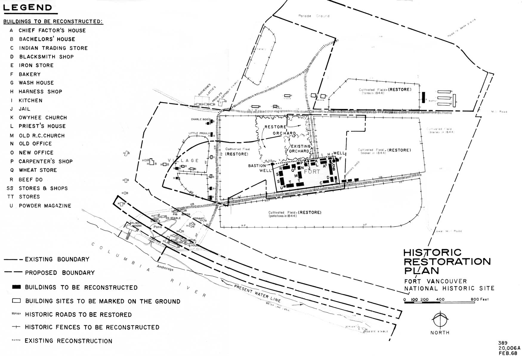
The accomplishment of this objective will require the reconstruction of the remaining three log walls of the stockade, the squared-timber octagonal blockhouse, and about 23 major squared-timber or frame buildings within the stockade. The interiors of certain key fort structures—such as the blockhouse, the Chief Factor's residence, the trade shop, at least one fur warehouse, the Bachelors' Quarters, the office, the bakery, the blacksmith's shop, carpenter's shop, jail, and powder magazine—will be reconstructed in whole or in part, and representative rooms will be refurnished. The interiors of several other structures will be adapted for interpretive uses—exhibits, audiovisual rooms, children's play area, and storage. Others will be used for visitor facilities such as rest rooms and lunch room.
Outside the stockade, several key structures in the village will be reconstructed, as will such auxiliary structures as the cooper's sheds, fences, barns, and sheds. Historic roads, the garden, the orchard, and some cultivated fields will be restored.
Related to restoration of the man-made scene will be an approximate re-creation of the original surrounding forest environment which has virtually been eliminated since historic times. This will require restoring native Douglas-fir and maintaining the land in a meadow condition, except those areas used for a specific purpose. The reforestation will preserve significant views into and within the historic area and screen out surrounding land uses.
The historic cultivated fields shown for restoration will be put into crops that require a minimum of cultivation and maintenance. One important element of the historic area has not been shown for restoration—the historic waterfront development. The possibility of eliminating the existing land uses that impede restoration between the fort and the river is so remote that inclusion of this area in the restoration plan has not been considered at this time. Future changes in land use, especially relinquishment of the S.P.&S. Railway, would have to take place before this area could be considered for restoration. The historic link between Fort Vancouver and the river is a very important part of the historic picture, and every advantage should be taken to restore it if the opportunity ever presents itself. Meanwhile, the waterfront strip will be landscaped in keeping with the historic scene to the extent practicable and in keeping with conforming recreation uses.
ACCESS AND CIRCULATION
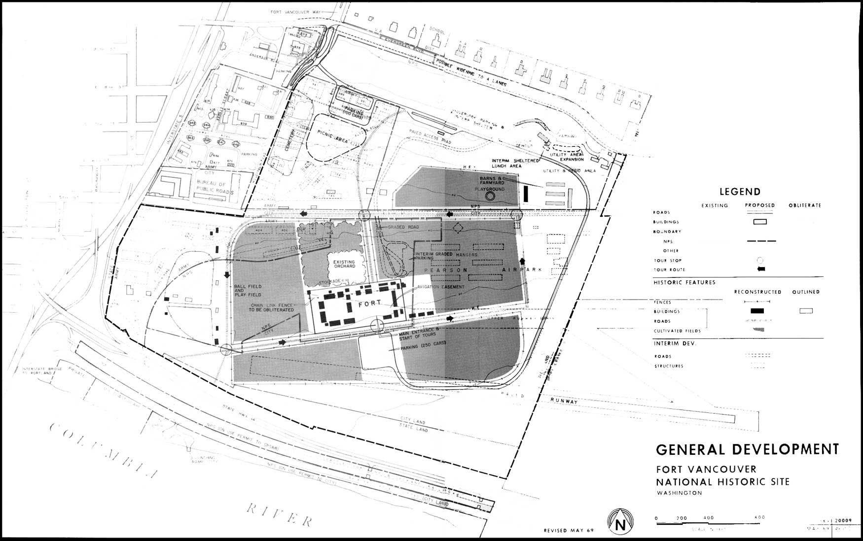
A two-way road will provide access as far as the reconstructed fort. This road will be routed around the perimeter of the site, thereby leaving the main part of the historic area free of automobiles.
The main approach to the area will continue to be on Fort Vancouver Way, but the maintenance to the site will be moved from East Evergreen Boulevard to McLoughlin Road. This will allow traffic approaching on Fort Vancouver Way to proceed directly through the East Evergreen intersection. This is especially desirable if East Evergreen is widened to four lanes. Entering the site from McLoughlin Road will afford the visitor an initial panoramic view of the historic area with the river in the background. A parking overlook is proposed at this point. Since McLoughlin Road is a city street, cooperation with the city will be necessary for modification of a portion of the road as shown on the General Development Plan.
Parking will be provided south of the fort at the end of the access road. In this location, the fort itself will completely screen the parked cars from important vantage points in the historic area, including the overlook.
An interpretive vehicular transit system is proposed from the fort to other features in the historic area. This is necessary due to the distance involved between the various features. It will also enhance the visitor's total experience to see the site from changing angles and perspectives as he moves through the area. The proposed route will form a loop beginning and ending at the south entrance to the fort and will follow the major system of historic roads. The restored system of historic roads will also be used as foot paths for those who wish to walk through the area.
|
| Historic Restoration Plan. (click on image for an enlargement in a new window) |
|
| General Development. (click on image for an enlargement in a new window) |
East 5th Street between East Reserve Street and McLoughlin Road is proposed for restoration as an historic road.
A picnic area, with shelter and sanitation facilities, should be provided away from the main historic area to accommodate school groups who have scheduled their trips during the lunch hour and as a convenience to other visitors. The best location is in a grove of trees east of the cemetery on land currently used by the Army as a barracks area. If it appears that acquisition of this land should not be feasible soon after reconstruction of the fort, a temporary picnic area should be located near the parking area at the fort.
As a convenience to visitors with small children, it is recommended that a supervised area for youngsters be provided, allowing parents more freedom to explore the area. However, rather than providing a conventional play area, it is proposed that one of the historic buildings in the fort (possibly the schoolhouse) be devoted to games and craft activities related to the history of the area and that interpretive story sessions be provided specifically oriented to small children as part of the total interpretive program. Linked to this could be an outdoor play area equipped with play equipment designed to relate to the historic period.
Providing an area in the fort specifically reserved for small children and designed to be compatible with the historic nature of the area would do much to enliven the visitors' experience by re-creating children's activities of the period, still maintaining the historical integrity of the area. As side benefits, it would be more convenient for the visitor, it would offer protection from the elements at a low cost through utilization of a restored building, and it would be easier to maintain and protect than in some other location outside the fort. There is sufficient space within the stockade to accommodate this proposal without interfering with other activities. This supervised play area would be operated by the park staff.
To help provide for day-to-day urban recreation uses, a ball field and play field are proposed outside the Fort stockade just to the west.
INTERIM DEVELOPMENT
There is an immediate need for a sheltered lunch area for school groups and a small parking area close to the fort site.
It is proposed that an open shelter lunch area be attached to the east end of the visitor center where it will be out of sight but close to the facilities of the visitor center, including the comfort station. After completion of the ultimate picnic area, this structure could be walled in and utilized for expansion of the headquarters.
The interim parking area at the fort site should be located along the east boundary adjacent to the air-park hangers. With additional screening along East 5th Street, this would be the least intrusive location to maintain the present view from the visitor center to the fort site.
Also, a program of clean-up, grading, and planting is needed along the riverfront.
COMMUNITY RELATIONS
Incidental and special uses by the local community not specifically related to the history of the area will continue to be allowed as long as they are compatible with the primary purpose of preservation and maintenance of the historic scene.
Portable staging and seating will be provided at the fort for local groups who may want to utilize the background of the fort for production of plays and pageants. Also, consideration should be given to hiring local theater groups to provide historic dramatization as part of the interpretive program.
Use of the area for Fourth of July celebrations (except fireworks which would endanger the restored fort) and for assembly of civic parades will continue to be allowed. However, more cooperation should be sought from the local community for cleanup and traffic control.
No special facilities, either temporary or permanent, should be provided for these activities. The parade ground will continue to be made available for parking for these special yearly events only, but the condition of the turf should be improved.
Local residents will continue to have free access throughout the area for activities such as walking, bicycling, horseback riding, and sports.
INTERPRETIVE FACILITIES
After reconstruction of the fort, it is anticipated that visitors will tend to bypass the existing visitor center or, if not, they will have made an extra unnecessary stop because of the distance between the visitor center and the fort; therefore, it is proposed that the main interpretive facilities be moved from the existing visitor center to the fort and incorporated into the reconstructed buildings. The existing visitor center would then be strictly for administration and storage of the area's large archeological collections.
Along the tour route will be a number of interpretive stops where visitors will be able to explore the various features in more detail. Stops will include the farm buildings, the orchard, and the garden, where historic methods of farming will be demonstrated and such long-disappeared features as oxen and Red River carts may be observed. Other stops will be at marked and interpreted historic sites such as the village, the mill, and the school houses.
It is proposed that a living farm exhibit composed of various farm animals of the period be located in the reconstructed barns and farm yard, with the restored fenced fields used for grazing.
To further enhance the historic character of the area, it is proposed that certain manufacturing activities such as blacksmithing, baking, and cask making be revived as live demonstrations of the daily activities of the period, with the products made available for purchase.
FEE COLLECTION
A fee is proposed for entrance into the fort, and would include use of the special tour vehicle. Visitors will have free access to the remainder of the site.
CONCESSION
With the number of activities proposed, it would be well to consider a concession operation. The location of Fort Vancouver in a large urban area suggests that this could be economically feasible. The concessioner could operate the special manufacturing demonstrations and sell the products along with other items in one of the historic stores in the fort. In addition, he could have a small lunch area in one of the restored buildings, and could operate the special transportation system. Special care would have to be taken with concession contracts and their implementation to insure that historical and aesthetic integrity is maintained.
LAND ACQUISITION
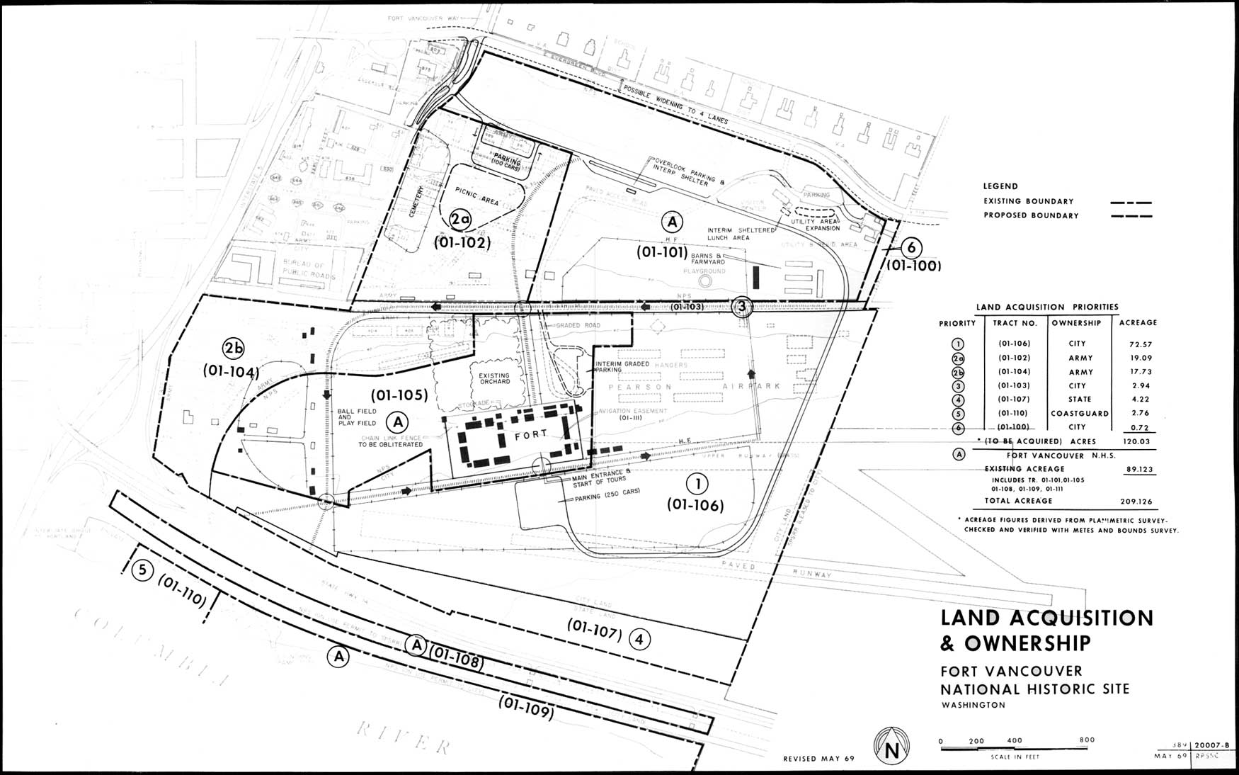
Acquisition of additional land is needed for restoration, development of visitor facilities, and to provide a proper setting and buffer between the restored area and existing and potential adverse surrounding land uses.
The land acquisition map shows the recommended boundary and the individual parcels that would have to be acquired and the priority of acquisition. The total acreage, including land within the existing boundary, is within the maximum of 220 acres allowable under current legislation.
Elimination of the existing upper runway aviation easement could precede acquisition of the airpark, allowing reconstruction of the fort to begin. However, early acquisition of the airpark land, Tract (01-106), is the most critical need in terms of restoration of the historic scene and development of visitor facilities. It is indicated as priority 1 on the Land Acquisition and Ownership map.
Tract (01-102), indicated as priority 2a, is needed for restoration of the historic scene by eliminating existing Army buildings for development of a picnic area and for preservation of the site of the fur-trade cemetery and the sites of several Hudson's Bay Company structures.
Tract (01-104), priority 2b, is needed for restoration of a portion of the historic village area and for further restoration of the historic setting through elimination of existing structures and control of the land use.
Tract (01-103), shown as priority 3, is needed to allow restoration of East 5th Street to a historic road and to eliminate an existing hazard to visitors. This street has received very little use between McLoughlin Road and East Reserve since it was blocked off at the expressway.
Tract (01-107), priority 4, is needed to control the land use between the fort and the highway right-of-way. Currently this area is used for fill dirt storage by the Highway Department.
Tract (01-110), shown as priority 5, is an important segment of the riverfront. It is required to prevent the construction of any high-rise or otherwise incompatible developments in the historic scene; also, should future land use changes permit historic restoration along the riverfront, this parcel contains the sites of several key features and would be urgently required for interpretive purposes.
Tract (01-100), priority 6, is needed to provide land use control adjacent to the existing Park Service residential area.
This program would complete the historic setting to the extent possible under current legislation.
Control over all the land down to the river would be desirable, allowing full restoration of the historic area between Fort Vancouver and the river. However, the intervening land uses are so firmly established that it is unrealistic to plan on acquiring them at this time.
|
| Land Acquisition & Ownership. (click on image for an enlargement in a new window) |
|
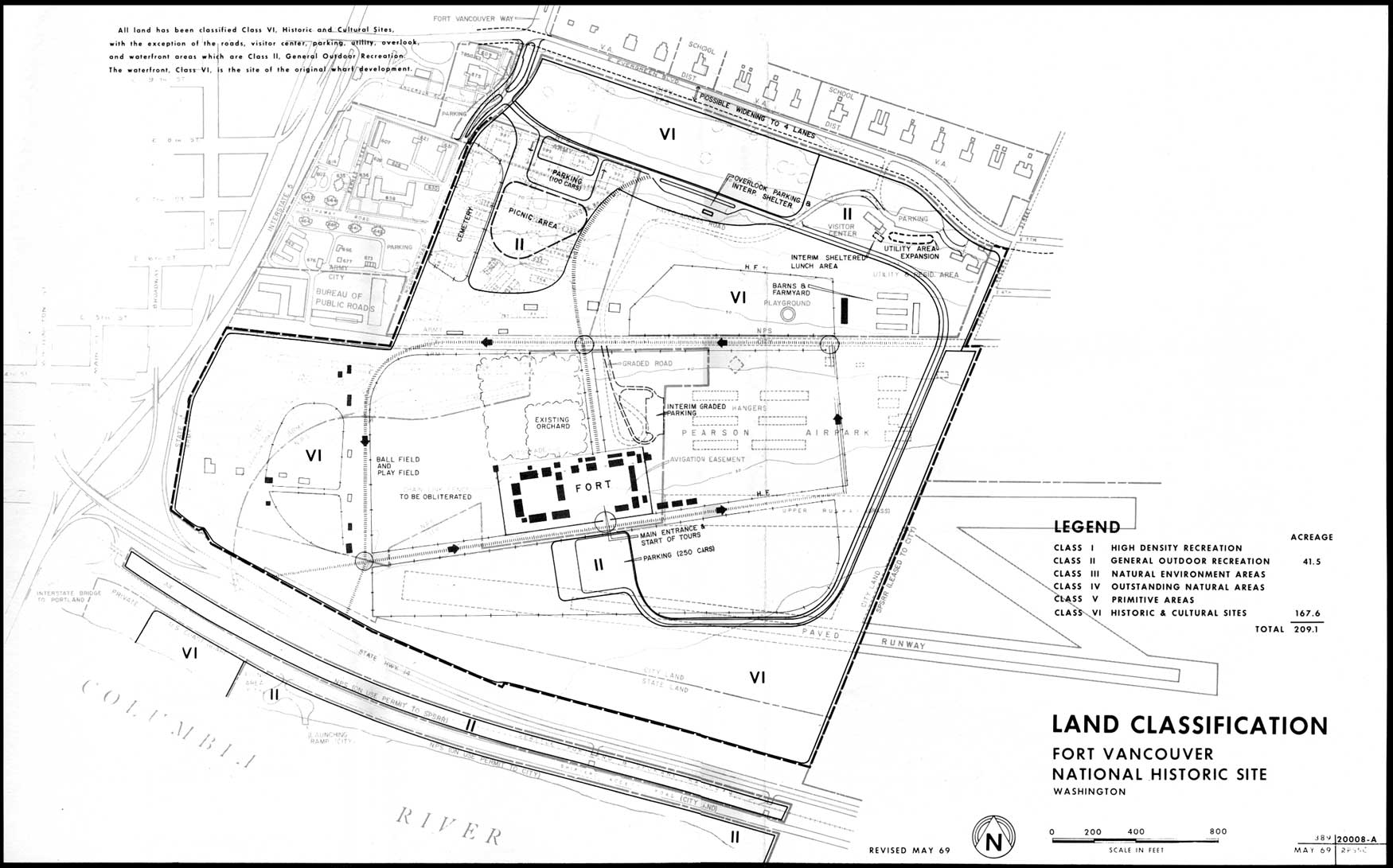
| Land Classification. (click on image for an enlargement in a new window) |
MANAGEMENT FACILITIES
Implementation of the plan will require additional staffing and maintenance facilities.
No additional staff housing is proposed beyond that which currently exists because of Fort Vancouver's proximity to adequate housing in the community.
It is proposed that as many of the maintenance functions as possible be contracted. However, expansion of the park maintenance program can be expected. Additional maintenance facilities will be located between the headquarters and the existing residential area.
LAND CLASSIFICATION
The land classification plan delineates potential land classification within the recommended boundary. It can serve as a guide to a course of action for conservation and use of the land. A brief narrative explaining the land classification appears on that plan.
|
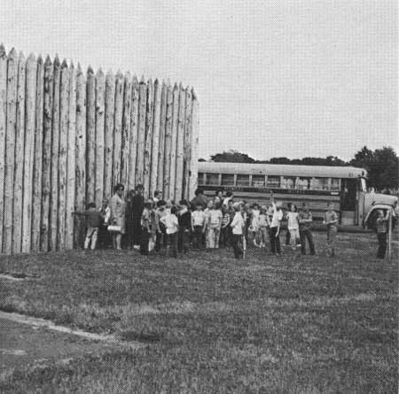
| School group visiting the site of old Fort Vancouver. |
PRIORITY OF NEEDS
The important projects proposed in the objectives and the plan will be carried out in the following order of priority:
1. Acquire airpark land and eliminate existing avigation easement.
2. Acquire remaining lands within proposed park boundary as they become available and in general order of priority shown on Land Acquisition and Ownership map.
3. Construct interim sheltered lunch area and fort site parking.
4. Conduct further historical, architectural, and archeological research at fort site.
5. Restore major fort structures.
6. Construct access road to fort; construct permanent picnic area with shelter and sanitation facilities or temporary one at fort site.
7. Develop ball field and play field in open area west of fort.
8. Further restore historic features surrounding fort.
9. Inaugurate tour system.
| <<< Previous | <<< Contents>>> |
master_plan/sec3.htm
Last Updated: 07-May-2007