|
FORT VANCOUVER
Master Plan |

|
THE REGION
Fort Vancouver National Historic Site is on the north bank of the Columbia River, within the corporate limits of the city of Vancouver, Clark County, Washington, and directly opposite the city of Portland.
For master planning purposes, the region within which the park is located is considered as comprising the Portland Standard Metropolitan Statistical Area. The Bureau of the Budget has defined this statistical area as having a population whose activities form an integrated social and economic system. It includes Clackamas, Multnomah, and Washington Counties in Oregon, with Portland the major population center, plus several outlying urban communities; and Clark County, Washington, which includes the city of Vancouver.
The principal natural feature within the region is the famed Columbia River waterway and the lower section of the spectacular Columbia River Gorge. Several major mountain peaks are readily visible in the distance and lend a scenic backdrop to what is an otherwise metropolitan setting. These include Mount St. Helens and Mount Adams in Washington and Mount Hood in Oregon.
|
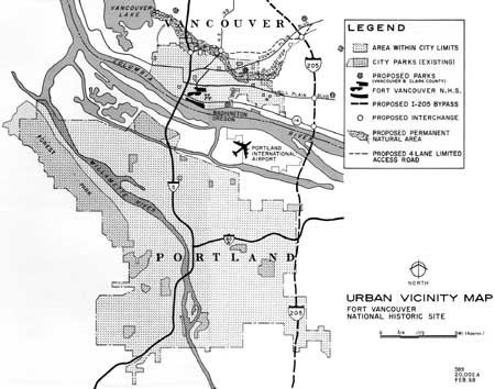
| Urban Vicinity Map. (click on image for an enlargement in a new window) |
|
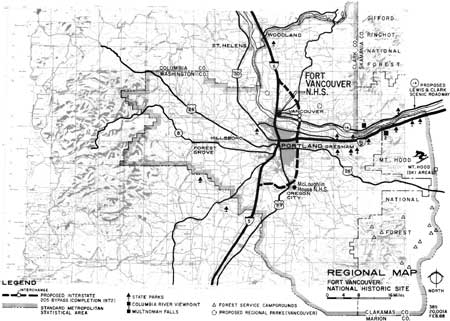
| Regional Map. (click on image for an enlargement in a new window) |
ACCESS AND CIRCULATION
The Columbia River waterway served as the principal transportation artery to and from the region during the early days of settlement. Then came the railroads, following the course of the Columbia along both shores, and with major lines extending into the region from the north and south as well. While several transcontinental passenger trains such as those of Northern Pacific and Union Pacific still serve the region, train passenger service is being reduced as it is elsewhere.
Components of the Interstate Highway System, feeding to major cities throughout the United States, serve the region. They include north-south Interstate 5 connecting Seattle, Vancouver, Portland, Los Angeles, and San Diego; and east-west Interstate 80N (formerly U.S. 30) following the length of the Columbia River Gorge and terminating at Portland.
The Portland International Airport is a major point of arrival and departure for both transcontinental and intercontinental air travel. Passenger traffic has more than doubled within the past four years, and exceeded two million in-and-out passengers in 1967. Extensive expansion of facilities is planned, probably at the present location but possibly by relocating somewhat farther south. Expansion will include facilities capable of handling the ultra-modern, super-sonic passenger aircraft.
The Pearson Airpark, operated by the City of Vancouver as a municipal airport, lies almost directly across the Columbia River from Portland International. It adjoins the present park boundary on the east and south. Only light private planes plus those of some Federal agencies use Pearson Airpark on a regular basis.
While present or future use of Portland International Airport will have little effect on park visitation, the noise created by low-flying jets during take-off will make it more difficult for the visitor to recapture the historic mood if airport facilities are expanded at the present location.
Fort Vancouver National Historic Site is only a few blocks east of Interstate 5, while part of the lands proposed for acquisition adjoin the Interstate right-of-way. Primary access to the park from either north or south is from an interchange at Mill Plain Boulevard, about three blocks northwest. The park can also be reached from a secondary Interstate 5 exit via downtown Vancouver. In either case, however, directional signs are either inconspicuous or lacking, and it is difficult for one unfamiliar with the locality to find his way to the park.
An additional but secondary means of access is available from the east via Washington State 14 along the north shore of the Columbia River. This route serves the industrial section of Vancouver and bisects the park. Pleasure traffic on this route is light at present. However, it is indicated in A Proposed Program for Scenic Roads and Parkways, published in 1966 by the President's Council on Recreation and Natural Beauty, as having been nominated by the State and by Federal agencies for study purposes as a scenic route.
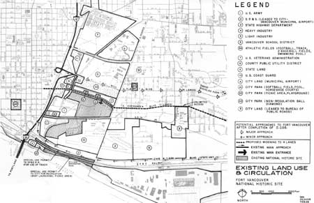
The principal access routes and features serving the region are shown on the Regional Map and the Urban Vicinity Map. Those having a direct relationship to the park itself are shown on the Existing Land Use and Circulation Map.

|
| The proposed visitor viewpoint, looking south toward the fort site. |
Access to the park is possible by private plane to Pearson Airpark; by taxi, rental car, or city bus from train and bus terminals in Vancouver and Portland; or by the same means from Portland International Air port. The use of such public transportation facilities, however, is impractical, and city bus service may be discontinued. Virtually all park visitors arrive by private automobile or, in the case of school or other organized groups, by bus service arranged specifically by those groups.
Visitation totaled 90,000 persons in 1967, compared with 63,900 in 1963; 37,600 in 1960; and 9,161 in 1957.
Proposed Interstate 205, to bypass Portland and Vancouver on the east as shown on the Regional and Urban Vicinity maps is scheduled for construction with a completion date of 1972. Interchanges will be provided in the Vancouver vicinity, including one from 205 onto Mill Plain Boulevard. Mill Plain is a four-lane, divided east-west thoroughfare, which carries local traffic. Its western terminus is at a major interchange on Interstate 5. Another interchange on 205 will be provided at its crossing with State 14.
With continued population growth and development of Vancouver, East Evergreen Boulevard, which forms the north boundary of the park, may also be widened to a four-lane street. In any event, East Evergreen will not connect with Interstate 5 and, while it does intersect with State 14, the intersection is a considerable distance to the east. Access to the park would be quite inconvenient by that route, and Mill Plain will continue to provide the principal means of access from both the Interstate routes.

|
| Entry to visitor center from the parking lot. |
POPULATION DATA
Portland, the regional population center, is within 20 minutes driving time from Fort Vancouver via Interstate 5.
Census estimates for mid-1966 placed Portland's population at 384,000 and Vancouver's at 38,300. According to these estimates, the population of Portland has grown by just over 3 percent since 1960, while that of Vancouver has grown by some 18 percent.
Similar estimates place the regional population at 908,000, in comparison with a population of 821,897 in 1960 and 704,829 in 1950. Thus the regional rate of growth since 1960 has been about 10-1/2 percent. This compares with a rate of slightly less than 10 percent for the Seattle-Everett Standard Metropolitan Statistical Area, the only other such metropolitan area in the Pacific Northwest.
Almost 80 percent of the region's resident population lives within the urbanized area. Like Vancouver, most of the growth in the Portland area has taken place in the urban fringes east of the central city. Favorable factors insure that this trend will continue.
Several State and Federal agencies, private industry, and research groups have made recent population forecasts which apply to the region. Consolidation of the studies to reflect a median forecast indicates that the region's population is expected to be in the range of 1,194,000 by 1980; 1,682,000 by the year 2000; and 2,600,000 by 2020 for a 40-year predicted growth of 118 percent. For Clark County, the same sources would indicate a population of about 146,000 by 1980; 206,600 by the year 2000; and in the range of 322,000 by 2020, a growth of 120 percent.
Fort Vancouver National Historic Site is used predominantly by the local population within the region. Tourist use is primarily by California residents and, secondly, due to their interest in the story of Fort Vancouver, by Canadian residents. This is an interesting comparison with the out-of-state tourist pattern in the Oregon State Parks system, where visitation is predominantly from California, with Washington second.
While regional population growth, of itself, has had no appreciable physical effect on the park, resultant industrial and economic development has altered extensively the surrounding scene, both restricting historical restoration and making it more difficult for the visitor to visualize the historical setting. Intruding elements of this nature are discussed under Surroundings and Existing Use below.
PARK AND RECREATION FACILITIES
Existing—No historical parks or sites in the entire Pacific Northwest compare in importance with Fort Vancouver for illustrating the role of the fur trade in the development of the western United States and Canada. There are, however, several parks that contain remains, sites, or reconstructions of lesser and subsidiary trading posts and which thus complement Fort Vancouver in presenting the fur-trade story.
Among these are Fort Nisqually in Point Defiance Park, Tacoma, Washington; Fort Langley National Historical Park (Canadian) near Vancouver, B.C.; Spokane House State Park, near Spokane, Washington; and Fort Okanogan State Park, Washington. Champoeg State Park, Oregon, about 35 miles south of Fort Vancouver, includes the site of a Hudson's Bay Company granary that was a part of the Fort Vancouver operation. McLoughlin House National Historic Site at Oregon City preserves the retirement home of Chief Factor John McLoughlin, who from 1825 to 1846 was in charge of Fort Vancouver. The museum of the Oregon Historical Society in Portland displays a number of artifacts associated with the Hudson's Bay Company region in the Northwest and with Fort Vancouver. A small city park at Astoria, Oregon, preserves a portion of the site of Fort Astoria, later Fort George, the predecessor of Fort Vancouver as the fur emporium of the West. The old Covington House north of Vancouver also is related to Fort Vancouver. The structure was built by a retired Hudson's Bay Company employee who took up land in Vancouver. A local landmark near the park is an apple tree which, according to legend, dates from Hudson's Bay Company days.
By stimulating interest in the history of the Pacific Northwest fur trade, these parks encourage visitation to Fort Vancouver, long the key focal point for the industry west of the Rockies. Also they provide at Fort Vancouver the opportunity to direct visitors to other sites where the fur-trade story may be further unfolded.
The region lies almost midway between the Cascade Range and the Oregon coastline, and there is a wealth of opportunities for scenic and recreational enjoyment, both within the region itself and within easy driving distance from the metropolitan area.
There are three wilderness areas, numerous developed recreational sites, and many scenic trails and loop roads in the Gifford Pinchot and Mount Hood National Forests on the west flank of the Cascades. One of the Pacific Northwest's major winter sports area is on Mount Hood.
In Oregon there are more than 30 State parks and at least two dozen county parks within easy driving distance from Portland.
The Portland Park Bureau has a highly developed and comprehensive City park system, ranging from a 3,600-acre natural and primitive area to community and neighborhood parks, offering a great variety of recreation facilities.
There are over 50 State, county, or commercial boat launching ramps on the Columbia and Willamette Rivers, supplemented by marinas, commercial moorages, and private yacht clubs.
One launching ramp, located on a 6.5-acre tract of Fort Vancouver land, was developed and is managed by the City of Vancouver as William Broughton Park under a special use permit from the Service, terminating in 1973.
Clark County itself has relatively few non-urban developed recreation facilities. It has one State park, a county park, a botanical area, a privately-owned park, and some of the boating facilities on the shore of the Columbia described above.
The Vancouver city park system comprises approximately 265 acres in about 36 individual parks, including eight community centers. Fifteen parks incorporate sports areas or outdoor play areas. Many of the parks are small, with from less than one to four or five acres each. About eight are undeveloped. David Douglas, the largest, contains 68 acres. Located three miles east of Fort Vancouver National Historic Site, it is predominantly a natural area.
The 11-acre General George C. Marshall Park is less than one-half mile north of Fort Vancouver, but across the four-lane, major thoroughfare of Mill Plain Boulevard. Present development includes 16 horseshoe courts, a non-regulation ball field, and a community center with indoor swimming pool.
The grounds of Hudson's Bay Senior High School, located across Mill Plain directly opposite Fort Vancouver, now provide an extensive open space area. A portion of the school grounds lies south of Mill Plain and has a football field, track field, and two baseball diamonds. The school also has an indoor swimming pool. Except for the athletic area, expansion of the physical plant will eventually utilize most of the present open space land.

|
| Old Vancouver Barracks officer's row. |
Quarnberg Park is two blocks east of East Reserve Street, the eastern park boundary. It also is on the opposite side of Mill Plain Boulevard. This is a small park of about 1.4 acres with a non-regulation ball diamond.
Esther Short Park is three-fourths mile west of Fort Vancouver across Interstate 5. It is developed for play ground activities and picnicking, and serves the southwest section of the city.
Facilities at William Broughton Park, mentioned above as being administered by the City under special use permit from the Service, consist of a concrete boat launching ramp, parking, and minor picnicking facilities.
The foregoing parks and open spaces are shown on the Existing Land Use and Circulation map.
Proposed—New areas are being added to the Federal, State, and local park and recreation systems in and near the region each year. Emphasis in the State program is being given to acquisition and development of State parks to serve future needs. Increased attention is being paid to the needs of urbanized areas, including northwest Oregon. Present State Park policy is oriented toward "functional" parks for active recreation.
The counties bordering the Willamette River are to acquire, develop, and maintain areas along the river under the newly-authorized Willamette River Greenway System, with State and Federal financial assistance and coordination.
The Vancouver Parks and Recreation Department of the Clark County-Vancouver Regional Planning Commission have prepared a comprehensive park and recreation plan for Vancouver and environs. The plan includes two regional parks; six community parks; and about 37 neighborhood parks. These new parks will have the normal city park developments including outdoor play areas and athletic or sports areas.
Some of the present Vancouver city park sites that are too small for useful development are being held as "trading stock" for acquisition of city greenbelt lands which also will be developed for general recreation purposes with play areas.
David Douglas Park will remain primarily for passive recreation, but proposed development also includes children's play areas, picnic facilities, and a replica in miniature of Fort Vancouver.
Proposals at Marshall include a totlot with play equipment, screens, benches, and shelters for pre-school and primary school age children, game areas, and a senior citizens' area.
|
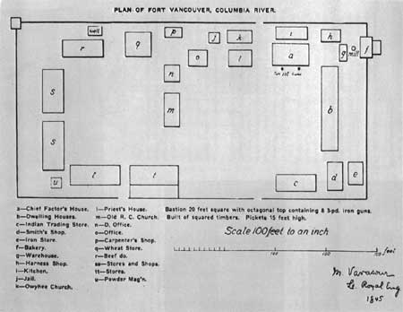
| Ground plan of Fort Vancouver, 1845, based upon map drawn by M. Vavasour. (Oregon Historical Society Quarterly) (click on image for an enlargement in a new window) |
SURROUNDINGS AND EXISTING USE
The location of the park on a former U.S. Army post has proven a fortunate circumstance in preserving a sense of historic integrity and open space in the immediate surroundings.
To date, these former Army lands have not been used for industrial purposes, to which the waterfront and adjacent area lends itself. Rather, they have been used for housing of Government employees, a high school, a community college, Veterans' hospital, library, public utility district headquarters, a city community park and recreation center, an airport, and city street purposes. A small part is still used by the Army. Otherwise, the general environment is that of an almost completely developed urban complex.
To the west, on lands within the proposed ultimate park boundary, is what remains of Vancouver Military Barracks, owned by the U.S. Army. Immediately west of the Army land is Interstate 5, with its easily visible, elevated ramp and major bridge crossing of the Columbia. To the west, just across Interstate 5, is the Vancouver central business district.

|
| Waterfront section of the park looking from the east boundary directly west. |

|
| The proposed visitor viewpoint looking west toward the remaining buildings in Vancouver Barracks. |

|
| Vancouver Barracks, looking south across the old parade ground, which is part of the park. |
Just across East Evergreen Boulevard, to the north of the park, are old Army residences known as Officer's Row, now occupied by Veterans Administration personnel.
To the east of the park on the opposite side of East Reserve Street are inexpensive, medium density residential developments. Both light and heavy manufacturing are located along the riverfront to the east and west.
|
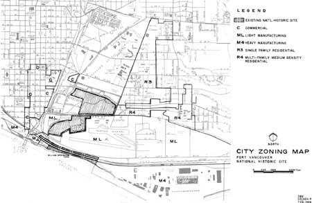
| City Zoning Map. (click on image for an enlargement in a new window) |
|
| Existing Land Use & Circulation. (click on image for an enlargement in a new window) |
OWNERSHIP OF ADJOINING LAND
Federal—U.S. Army—in use by organized reserve corps. U.S.Coast Guard—actively used as Coast Guard head quarters. Veterans Administration—used for major hospital facilities; a substantial portion of the lands, plus a small detached parcel, are maintained as open space.
State—State of Washington—one parcel is the location of Clark Community College. A second parcel is held by the State Highway Department. It includes the right-of-way for State Route 14 and a larger portion used for the storage of highway construction materials.
Local—Clark County Public Utility District—used as P.U.D. headquarters. City of Vancouver—Pearson Air-park with hangars and runways; city also owns East Fifth Street through the park and a parcel on East Reserve Street adjoining park headquarters. Vancouver School District—senior high school buildings and grounds.
Private—Seattle, Portland, and Spokane Railway—not actively used at present, but is under lease to City of Vancouver for airport purposes. Lease is revocable at will by S.P.&S. A 100-foot right of way on which the railroad is located is a part of Fort Vancouver National Historic Site, with Congressional grant to the railroad for its operation.
Gilmore Steel Corporation—Former Vancouver Shipyards. In major use for manufacture of steel, wood, and aluminum products.

|
| Historic Vancouver Barracks parade ground (in park) looking west. |

|
| Gilmore Steel Company's heavy industrial complex 1/2 mile east of the waterfront. |

|
| SP&S Railroad fill across park lands, showing the recent addition of fill for double tracing. Road in foreground is city access road to Gilmore Steel Company industrial complex. |
While the immediate surroundings still retain a feeling of openness, existing land uses have introduced several seriously restrictive and intrusive elements, both physical and legal. These elements disrupt the historical scene or prevent its re-creation.
One of the most intrusive elements in the scene is that of vehicle traffic passing quite close to the fort site on State Highway 14. Just beyond the highway and paralleling it is the high embankment of the S.P.&S. Railroad which blocks any view of the river except for its far side. And beyond the railroad embankment is a paralleling city street serving the riverfront industrial area. Thus the once-intimate relationship between the fort and the river no longer exists today, or at least it is much more difficult to comprehend.
Another physical barrier is the SP&S railroad spur, which extends in a semi-circle along the present west boundary of the park. A siding and coal tipple is located at the end of the spur adjacent to the present park boundary on the north.
Of particular importance to park development are certain adjoining tracts on which incompatible uses exist. The riverfront strip owned by the State Highway Department and directly fronting the park demonstrates the type of adverse use and damage to the historical scene which may occur if not in the control of the Service. Except for State Highway 14, this land has so far been used only for the storage of huge piles of construction materials.
The dominant adverse use is posed by Pearson Air-park. The present avigation easement constitutes an adverse legal factor which effectively prevents any further restoration of the Hudson's Bay Company post. Physical facilities in the form of hangars and runways are intrusive elements and, to a lesser degree than the easement, prevent historical restoration.
East 5th Street occupies the site of the historic Hudson's Bay Company road. In its present form, it separates two important segments of the park and is a safety hazard to visitor traffic.

|
| Unsightly storage area across airport from park, looking across runways toward reconstructed stockade. |

|
| Looking southwest toward the reconstructed stockade from Fifth Street. |

|
| Map of Fort Vancouver and village in 1846, drawn by R. Covington. (Hudson's Bay Company) |
An important legal factor concerns this street; when parts of the Army post were declared surplus, through streets with significant amounts of traffic like East Fifth were deeded to the city under reversionary clause. The clause provides that title can be recaptured if not used for street purposes by the city.
Potential adverse uses now exist on lands that are essential to park protection and scenic preservation. The U.S. Coast Guard headquarters, located on the riverfront in direct view from the fort site, may be moved to another location in the Portland area within the next two to three years. The land may then become available to the Service, or open to adverse development if not acquired.
Another potential adverse use is presented by East Reserve Street on the eastern park boundary. Street widening is under consideration and, if the parcel adjoining the park administrative headquarters is not acquired, resultant widening will place street traffic just outside employee residence windows.
Trends in Land Use—The current trend in land use on adjoining properties is a factor that further justifies their early acquisition. The trend, as is graphically shown on the City Zoning Map, is predominately one of increasing industrial development expanding toward or encroaching on the park. To a lesser extent, the trend toward continued commercial development will have a similar effect. With some exceptions, most of the commercial expansion will be physically separated from the park by existing Interstate 5.
REGIONAL ANALYSIS
The primary attribute of the park in the land use pattern is that of a large open space in an urban complex of 38,000 population and the opportunities it provides for public use and enjoyment in this important setting. Its importance in this role will be further enhanced by improved access, the demands of continued population growth and urbanization, and acquisition of additional adjoining lands.
The tremendous number and diversity of recreational opportunities generally available to the region's residents have little influence on the actual use of the park, since the day-to-day visitors are principally those with historical interests. Such interest is increasing in the region. Because the park is the largest open space with a waterfront location in the city, it is an ideal site for community gatherings like the annual Fourth of July observances.
| <<< Previous | <<< Contents>>> | Next >>> |
master_plan/sec1.htm
Last Updated: 07-May-2007