|
FORT VANCOUVER
The Administrative History of Fort Vancouver National Historic Site |

|
Chapter Six:
PEARSON AIRPARK AND THE DEVELOPMENT OF FORT VANCOUVER
Pearson Airpark encompasses two distinct parcels with rather different histories. The eastern half of the site, east of East Reserve Street, was owned by a succession of railroad companies from 1930, when the City of Vancouver first leased it for the development of a municipal airfield, until 1972, when the city purchased it. The western half of the site, now part of Fort Vancouver National Historic Site, has a more tangled history of ownership. The Hudson's Bay Company, which left Fort Vancouver in 1860, surrendered its fur post to the United States Army as part of a court settlement in 1869. By the mid-1920s, the site was developed as Pearson Field for the Army Air Corps. In 1949, the City of Vancouver obtained the western half of the present Airpark when parts of Vancouver Barracks were declared surplus. Pressure from Burlington Northern to buy the eastern half of the site and the National Park Service's interest in obtaining the property for Fort Vancouver National Historic Site led to the sale of the western parcel to the Park Service in 1972. This sequence of ownership is easy enough to trace. More difficult, however, is to document and evaluate the relationship between these owners, their intentions for the Pearson Airpark property, and the historical significance of the land's use over the past century and a half.
Silas Christofferson's June 11, 1912 flight between Portland and Vancouver Barracks is the first documented landing of an aircraft in the immediate vicinity of the present field. [1] Observers of Christofferson's flight recalled that he used the polo field at Vancouver Barracks for his landing, which was just west of what soon became the Army Air Corps airfield. [2] While no permanent runway was established prior to the 1920s at this site, which continued to be used as a polo field by the officers at Vancouver Barracks, a number of Army and local aviators used the open field for their experimental flying until the First World War.
The polo playing and the aviation experiments were discontinued during World War I when the United States built a spruce mill on fifty acres of the site to provide lumber for American aircraft factories. Between November 1917 and the end of the war, the 30,000 officers and enlisted men of the U.S. Army Corps' Third Spruce Production Division produced about nine million board feet of spruce lumber monthly. Though the spruce mill was in operation for a little under two years, the buildings remained on the site for several years after the war's end. [3]
Due to the lack of funding for Air Service activities after the war, the Army did not resume the use of the Barracks' airfield until 1921 when the Forest Patrol, a cooperative effort between the Air Service and the U.S. Forest Service, was stationed there. Keeping the landing strip open, however, proved to be an on-going problem because of its location in the flood plain of the Columbia River. Periodically covered with water which prevented its use, local news accounts indicate that the field's condition was a factor in the Army's decision to relocate the airplane Forest Patrol unit to another field by 1925. The privately contracted airmail service that originally operated out of the field in 1926 also moved, relocating to Portland in 1928 because of the limitations of the airstrip. [4]
On September 16, 1925, the airfield was officially dedicated as Pearson Field, in memory of Lt. Alexander Pearson, a noted military aviator killed in an airplane accident the previous September. The field was restricted to military use, primarily the Reserve Army Air Corps, except in emergencies, by a 1925 ruling which restricted civilian use of military fields. [5] Thus excluded from Pearson, a few pilots established a civilian airfield, east of East Reserve Street, on land owned by the Spokane, Portland & Seattle Railroad. This civilian strip evolved into the Vancouver municipal airport, which formally opened on the railroad property May 25, 1930. The city leased the seventy-acre airfield from the Spokane, Portland & Seattle Railroad on a year-to-year basis with no long-term agreement. [6]
In 1941, Pearson Airpark ceased to be an active Army Air Corps base. Both United States Army planning drawings and aerial photographs show that the Army intended to develop Pearson Field for non-aviation purposes during 1944 and 1945--perhaps for military housing during World War II. By 1945, a grid of streets had been laid out, named, and graded onto what had been the airfield. The U.S. Army most likely put these expansion plans on hold at the end of the war and, in December 1946, announced that much of Vancouver Barracks, including Pearson Field, would become surplus property under the Surplus Property Act of 1944. The War Assets Administration (WAA) was appointed as trustee to distribute the surplus property. [7]
In July 1946, even before the Barracks property was officially declared surplus, the City of Vancouver unofficially consolidated the old municipal airport with Pearson Field, linked the two runways with grading, and renamed the entire site "Pearson Airpark." [8] During this postwar period, the main turf runway ran parallel to the Columbia River, in the vicinity of the current strip. Most of the runway was on the Spokane, Portland & Seattle property. By the 1940s, the city formally leased this property on a long-term basis from the railroad for $500 a year and annual tax payments. [9] A northern runway crossed the old Hudson's Bay Company fort site, but by the mid-1940s it was probably not used except during high waters, when the southern runway was inaccessible. Neither runway was paved until 1966 when the lower runway was filled to stop flooding and asphalt was laid.
The National Park Service also had an interest in surplus property at Vancouver Barracks. In March 1947, O.A. Tomlinson, the Region Four director, met with the Fort Vancouver Restoration & Historical Society and the Vancouver Chamber of Commerce about acquiring lands once occupied by the Hudson's Bay Company's Fort Vancouver for a national monument. Because the fort site was on land for which the City of Vancouver had also applied, the Park Service, the city, and the War Assets Administration had to negotiate the best disposition of land. The Park Service originally wanted most of the land surrounding the fort site. But O.A. Tomlinson "decided to apply only for lands which were not essential for the operation of Pearson Air Field." The WAA, however, suggested that the Park Service apply for the fort site land before the option expired and then work out any conflicts directly with the city. So, on March 13, 1947, the National Park Service made formal application for the fort site within Vancouver Barracks. [10]
The following month the regional director, still faced with resistance from the city, lamented that:
because we signified our desire not to accept the whole of Pearson Field and then give the City of Vancouver a special use permit for that part to be used as an airport, the War Assets Administration felt they could accomplish the same result by deeding to the City of Vancouver the entire field with the understanding that they would in turn grant the Park Service a permit to use the Hudson Bay Stockade area. [11]
To help resolve the overlapping land claims of the city and Park Service, Park Service historian Dr. Aubrey Neasham and planner B.F. Manby visited the site on April 23, 1947. Manby assured the city that if the fort site was included within the proposed monument boundaries, the National Park Service would "adjust the east and south boundaries,...place only flat markers at the fort site, and...restrict visitors from walking out onto the fort site." [12]
With these assurances, the City of Vancouver agreed to revise its surplus land application in the spring of 1948 to allow the parade ground and the fort site to go to the Park Service for the purposes of a monument. Once more, the WAA delayed a formal land transfer to either the City or the National Park Service pending the outcome of proposed legislation to establish Fort Vancouver National Monument. [13] Legislation to authorize the monument was signed by President Truman on June 19, 1948.
Once the conflicting claims between Vancouver and the Park Service were settled in April 1949, the WAA transferred the title to the western half of the Pearson Airpark property to the city, formalizing the unification of the military and municipal airfields made 3 years earlier. A clause in the deed restricted use of the property to airport purposes only and provided for reversion to the federal government if the property ceased to be used as an airport. In addition, the government had the right to take control of the property during a national emergency and required the sale, lease, or disposal of any of the property be approved by the Civil Aeronautics Administration, later the Federal Aviation Administration (FAA). [14]
The Spokane, Portland & Seattle Railroad continued to own the eastern portion of Pearson. During May 1949, the WAA transferred the fort site to the Department of the Interior, to be included in Fort Vancouver National Monument. The letter of transfer contained the four conditions that would affect future negotiations over the Fort Vancouver site and reconstruction of fort structures:
1. no structures could be built on the area now within Pearson Field;
2. only flat markers could be placed at the corners of the old structures, and the entire area must be kept free from obstructions;
3. visitors had to stay off the fort site; and
4. the property was to be subject to an easement and right-of-way, for the benefit of Pearson Field, for the free and unobstructed passage of aircraft in the air space over the granted lands. [15]
Though this was ultimately an unsatisfactory solution for the Park Service, it allowed it to obtain the original Fort Vancouver site for a national monument and preserved remaining cultural resources for future archaeological study. But, in order to maintain aviation at Pearson on the existing runways, the National Park Service was effectively restrained from developing the site for interpretive purposes.
Pearson in the 1950s
The 1950s were not very successful years for the young municipal airport. Besides the practical problems of having the main runway located on a flood plain and the threat of commercial development to the east, the fiscal health of Pearson Airpark was at times in doubt. [16]
In the mid-1950s the Vancouver City Council "expressed their private and unsolicited opinion" to Fort Vancouver Superintendent Frank Hjort that the city might be willing to close the Airpark "if the National Park Service will receive the land now used for airport purposes." [17] Again in 1958, the City Council investigated closing the airport and purchasing land outside the city limits for airport purposes, which "would release the Spokane, Portland and Seattle Railway property immediately east of the city-owned airport property for industrial purposes." [18] The city then decided it would continue to operate Pearson field but with no further investment in the property. [19]
In fact, in February 1959, the City Council disbanded the Vancouver Board of Aeronautics and appointed a new Aviation Committee in an attempt to plan for discontinuation of Pearson. The committee's role was to "advise the Council on aviation problems and to study possibilities of relocating the airpark should a move become necessary." [20]
Principal tenants of Pearson sensed an insecure future at the airport. In June 1961, Art Whitaker, "the principal occupant of the city of Vancouver's airpark, closed his distributorship for Piper products for the Pacific Northwest. It has been reported that the move was made at the Piper Company's request because of the inadequate facilities at this airfield." [21]
At various times during the 1950s, Pearson Airpark operated in the red. But there were several other reasons that the City Council did not want to invest in any further development at the airport. Primarily the city could not get a longer lease on the railroad property east of East Reserve Street which incorporated most of Pearson Airpark's operations. State law also prohibited the city from issuing additional revenue bonds for airport improvements. Finally, the city realized that it might have to give up its avigation easements if federal funds were appropriated for reconstruction of Fort Vancouver. [22]
Pearson Development in the 1960s
Despite the uncertainty of Pearson's future in the early 1960s, the City of Vancouver began to plan for the Airpark's development. The city sold a 4.22 acre parcel of the western property to the Washington State Highway Department on March 22, 1961, for road construction purposes. In return, the city received $25,600 which it slated for new airplane hanger construction. [23] However, the quit-claim deed did not reference the original 1947 War Assets Administration deed for Pearson which required that the city use the property only for airport purposes. In a later memo to the director of the Park Service, Superintendent Eliot Davis wrote that lawyers for Vancouver's Airport Committee determined that "the sale of land by the city to the State of Washington was probably illegal although no one protested it at the time of the sale." [24]
On August 23, 1963, the city acquired 4.7 additional surplus acres of Vancouver Barracks to extend the lower runway at Pearson. The deed for this transfer applied the same use restrictions as the 1947 Deed. [25] By the fall of 1964, the city informed the FAA of its intention to extend the 3,400-foot lower runway to 4,200 feet at the west end of the airport. Even though the FAA "`withheld action' on the city's notice of intention," the City of Vancouver proceeded to mow the grass, making an 800-foot sod overrun at the end of the southern runway. [26]
Although it had assisted the city in obtaining the surplus property in 1947 and had created restrictions for the avigation easement over the Fort Vancouver site, the FAA was hesitant to support any further development at Pearson. Indeed, in July 1964, the FAA began to pressure the city to relocate Pearson. Joseph Tippets, Los Angeles FAA regional director, recommended relocating the airpark "not only because of air traffic problems which are developing, but also because [the] city is growing and will ultimately need a larger airport." [27] New FAA regulations had recently been developed for small airports and Tippets could foresee the potential problem of conflicting air space with Portland International Airport across the Columbia River, as well as conflicts with the Interstate expansion. Tippets told Vancouver that the sale of Pearson property could finance new runway construction and federal assistance could help relocate the airport. But Allan McCoy, the airport manager, said that they had no intention of moving the airport. [28]
While the FAA remained adamant about the serious safety hazards posed by Pearson, it also supported further Pearson development plans. In a May 1965 meeting with Manuel Morris, the acting regional chief of the Division of Land and Water Rights in the Park Service's Western Region, the FAA admitted that it had limited itself when it supported the city's application for surplus Vancouver Barracks property in 1947. Though it supported the airport's relocation, the FAA could not "reverse itself without embarrassment." [29] Thus the FAA initiated seemingly contradictory policies on Pearson Airpark. On one hand, it strongly suggested relocation of the airport, yet it also funded an airport development study in the fall of 1966, by Leigh Fisher Associates, Inc., professional planners from San Francisco, which recommended expanding the facility. The first sign of new development appeared in October 1966 when Pearson Airpark paved its south runway. Until 1961, the main runway had been turf, then gravel topped. In 1966, three thousand feet of the runway was paved at a cost of $35,000, which the city hoped would improve the Airpark's business. [30]
Leigh Fisher Associates' final airport development report, available in March 1967, recommended as a priority the purchase of the Spokane, Portland & Seattle Railroad property which was still under lease to the city. The report also recommended removing restrictions of the original 1947 quit-claim deed in order to develop the entire property, estimating the total project would cost about $1 million. Others in the city thought the report did not go far enough. Harold Kern, Chairman of the Airport Advisory Committee, wanted to keep the north runway, which went through the fort site, remove the original quit-claim deed restrictions, and turn the south end of the field into "revenue producing property for the Airport." [31]
The city's consideration of more intense development of the Pearson property concerned the staff at Fort Vancouver. "If the City has unrestricted use of the land," Fort Vancouver Superintendent Eliot Davis wrote the regional director in April 1967, "it can be sold for private industrial use as it is already zoned for light industry. As Fort Vancouver adjoins the Airpark this could ruin the setting of Fort Vancouver." [32]
Nonetheless, two new hangars were to be constructed adjacent to the fort site. In April 1967, the Park Service objected to this proposal "as it will cut off the view of the east wall of the Fort from the Visitor Center." The city manager promised that the hangers would be removed if the Spokane, Portland & Seattle Railroad lands and other private lands were ever owned by the city. The City of Vancouver then suggested that the National Park Service help them purchase the railroad lands, the avigation easement over the fort site, and the western portion of Pearson, so that they could remove the hangars. [33] However, at this point, the Park Service was primarily concerned with the development of Fort Vancouver itself.
Development of Fort Vancouver in Relation to Pearson
Although the Park Service had conceded to certain restrictions on the use of the fort site when the War Assets Administration transferred the Pearson property to the City of Vancouver in 1949, early planning goals for the monument included eliminating the runway and avigation easement which ran through the fort site. In the early 1950s, Superintendent Frank Hjort met with the Vancouver Aeronautics Board to discuss the runway and they agreed in principle that if the lower runway "could be filled enough on the east to place it above the high-water stages of the Columbia," then the upper runway could be eliminated, since it was needed only during flood stage. [34]
In 1960, the National Park Service again broached the question of moving the existing avigation easement which restricted use of the fort site. The Park Service could not plan reconstruction or further the interpretation of Fort Vancouver as long as the northern runway remained. The Park Service thought the northern runway was not essential to the continued operation of the airfield, but the City Council and Pearson Airpark wanted to keep the runway because of flooding problems and, according to City Manager Robert Clute, air turbulence on the south runway. [35]
On the other hand, the City of Vancouver was interested in "acquiring a small portion of the southerly part [of Vancouver Barracks property] in order to extend a runway." This same property was within the ultimate boundaries of Fort Vancouver National Monument and part of desired legislation that would authorize this expansion. Robert D. Clute, city manager, wrote Julia Butler Hansen, newly elected congressional representative for Washington State's Third District, that they did "not wish to obstruct the wishes of the National Park Service, but we do not feel that this portion would hamper their overall development." Clute mistakenly implied that the city "originally gave the land, that they now occupy, to the National Parks [sic] Service and for this reason we feel somewhat justified in this small request." [36]
It was not until 1961, when Representative Julia Butler Hansen introduced legislation to expand the maximum acreage for Fort Vancouver to 220 acres and change its designation to national historic site, that the means to reconcile the conflict materialized. The legislation, signed into law by President Kennedy on June 30, 1961, anticipated reconstruction of the fort site and additional land acquisition, including the western portion of Pearson Airpark. George Hartzog, the director of the National Park Service, later wrote Congresswoman Julia Butler Hansen that it was the Park Service's understanding "that certain lands under the jurisdiction of the Department of the Defense and lands owned by the City of Vancouver and utilized as the Pearson Airpark would eventually be added to the Site." [37] The city, having been reassured that it could extend its lower runway if it acquired a piece of land not important to Fort Vancouver's development, withdrew its objections to the legislation. [38]
Though the acquisition of the Pearson property was not accomplished for another ten years, the City of Vancouver, the secretary of the Interior, and the FAA agreed to modify the avigation easement on February 27, 1962, to allow reconstruction of the north wall of the fort, which was built in 1966. [39] However, the bastion construction was delayed because it exceeded the FAA height limitation by 13 feet, coming into conflict with the airspace requirements for the modified easement. [40]
As early as October 6, 1964, the first plan for acquisition of property at Pearson was proposed by Superintendent Hal Edwards. His proposal for Pearson Airpark "relocation" was not only endorsed by the mayor, but had been originally suggested to Edwards by Harold Kern, chairman of the city's Airport Advisory Committee. The "Edwards Plan" suggested that the National Park Service purchase "land east of the old Military Reservation owned by SP&S Railroad and private parties" thus preventing "heavy industry" from locating on the property. In exchange, the north runway would be moved south to reconfigure Pearson so that the fort site and stockade could be rebuilt. However, Edwards' proposal would have required that the Park Service deed the Spokane, Portland, & Seattle land back to the City of Vancouver, transferring ownership of the entire Airpark to the city. [41]
Hal Edwards' untimely death in November 1964 left many questions about his proposal unanswered. His successor, Eliot Davis, struggled with the repercussions of the "Edwards Plan" since some people in the Vancouver community thought that the Park Service had approved the plan. In July 1965, Eliot Davis wrote to the regional director that he told a member of the Chamber of Commerce "that this was not a valid plan and had never been one. It was an idea advanced by Mr. Edwards, the former Superintendent, but never approved by higher authority." [42] By January of the next year, Davis had "repudiated any verbal commitments that may have been made [under Edwards, which] still continue to plague us." [43] Indeed, the City of Vancouver continued to use Edwards' report to pressure Senators Henry Jackson and Warren G. Magnuson and Representative Julia Butler Hansen to pass legislation to appropriate Park Service funds to pay for the expansion of Pearson Airpark. [44]
Throughout 1966, several prominent men in Vancouver promoted both the reconstruction of Fort Vancouver and the upkeep of Pearson Airpark. Gus Norwood, executive secretary for the Northwest Public Power Association, told Representative Julia Butler Hansen that he felt that "the Fort and Airpark can live together in harmony and on a complimentary basis." In order to do this, however, the Park Service had to purchase the Spokane, Portland & Seattle Railroad property for the city. Norwood also wanted the Park Service to "reimburse the City of Vancouver for the costs of removal and relocation of the upper runway and airport buildings." [45] J.E.N. Jensen, assistant director of the National Park Service, wrote Representative Hansen that though the Service was interested in the development of Fort Vancouver National Historic Site, "we entertain serious doubts that the expenditures involved in Mr. Norwood's plan could be justified." [46]
Pearson Commercial Development
At the same time that the modified avigation easement opened up limited possibilities for development at Fort Vancouver, the City of Vancouver explored the possibilities of the commercial development of the adjacent Pearson property as recommended by Leigh Fisher Associates. In July 1966, the city attempted to obtain a release from the 1947 quit-claim deed restrictions to allow development of non-airport uses. Edward Hummel, the Park Service regional director, advised the director that release of the terms would adversely affect the future of Fort Vancouver National Historic Site. [47]
By the following year, the Spokane, Portland & Seattle Railroad encouraged the city to buy from it the eastern half of Pearson Airpark, which was valued at about $600,000. The city explored the possibility of an exchange of city-owned waterfront lands for the parcel, but the railroad would not accept an exchange. [48] Next the city asked the Park Service to buy the avigation easement over the fort site for $600,000 to allow them to purchase the Spokane, Portland & Seattle land. [49] The Park Service rejected this proposal.
At the end of the summer of 1967, the City of Vancouver again asked the FAA to release it from the 1947 deed restrictions. [50] After meeting with Park Service representatives in October 1967 to discuss the city's request, the FAA recommended denying its request "until such time as arrangements can be made for the selection and construction of a replacement airport and the airport property released for sale and acquired for the planned development of the historic site." [51]
Based on these meetings, the FAA again strongly suggested that the city look for another airport site, because it would not support further development at Pearson. Three suggested alternate airport sites included Evergreen Airport, Orchard, and the Vancouver Lake Complex. Portland International Airport's plans to expand in early 1968 also added urgency to the issue of relocation, since the proposed flight paths would encroach on Pearson air traffic. [52] Indeed, the FAA proposed that all Pearson traffic fly to the north to avoid potential conflict. [53]
The Fort Vancouver 1969 Master Plan and Pearson Airpark
Since the Fort Vancouver National Monument Boundary Status Report of 1955, the proposed ultimate boundaries for Fort Vancouver included the western portion of Pearson Airpark, which had previously been part of the Hudson's Bay Company's Fort Vancouver complex. When the National Park Service formed the Fort Vancouver Master Planning Committee in 1967 to plan a direction for the site's future development, the acquisition of the Pearson property became a priority. [54] In August, R.B. Moore, acting regional director, Western Region, suggested that if
appropriations could be obtained to purchase land which the Federal Government has so recently donated, we would prefer to see the Service purchase or otherwise obtain from the City all of the airport lands within our proposed ultimate boundaries; these lands could then be leased back to the City for airport runway purposes. [55]
The planning committee's primary concern was that the fort site be freed for reconstruction. In addition, the surrounding historic scene could be restored to provide more accurate interpretation of the site. The 1969 Master Plan for Fort Vancouver reiterated the priority of acquiring Pearson to make these goals possible.
The Park Service explored several options for acquiring the Pearson property. In April 1969, it asked the Army for custody of thirty acres of former Veterans Administration property to exchange with the city for the Pearson Airpark land. [56] By the end of the year, Superintendent Eliot Davis hoped that Ken Puttkamer, airport manager, "would cooperate in a land exchange if they locate another airport site near, or on, Government lands. We understand that an area near Brush Prairie is under consideration which includes a small area of Federal land." [57]
The land exchange never worked out, but the new city manager, Alan Harvey, continued to pursue alternative solutions to the land use conflict. "During the next phase of expansion at Fort Vancouver," Harvey wrote to Representative Julia Butler Hansen in December 1969, "we believe that land at the airport could be sold or transferred to the National Park Service or the avigation easement over the Fort might be altered to allow for expansion of the Fort, and at the same time flying from other portions of the airport could continue on a reduced scale." [58]
The Park Service eventually hoped to move the airport to incorporate the property into the historic context of Fort Vancouver. In January 1970, Eliot Davis again suggested that the Park Service purchase the Pearson property but with a limited special use permit to the city "with enough time to phase out the airport and move it to another site." [59] Alan Harvey agreed that the Park Service should consider purchasing 73 acres of city-owned airport property which he valued at $730,000. He also suggested that the city and the Park Service enter into a long-term lease agreement to allow continued operation of the airport for a definite number of years, with a modified or discontinued avigation easement which would allow for the reconstruction of the fort stockade. [60] The city would then purchase the eastern 62 acres of Pearson from Burlington Northern Railroad, who now owned the Spokane, Portland & Seattle Railroad property. Harvey also admitted to Superintendent Eliot Davis that "pressure from the public and from the City Council is calling for reconstruction of Fort Vancouver." [61]
Negotiations for the Purchase of Pearson
While the Park Service contemplated the idea of purchasing the city's property to incorporate it into Fort Vancouver National Historic Site, City Manager Alan Harvey contacted Burlington Northern to ask that the company consider donating the 61.8 acres of leased airport land, or a portion of it, to Vancouver. Harvey cited the tax advantages and the potential public relations coup that such an action would create. [62] Burlington Northern did not take to the suggestion.
In the spring of 1971, serious negotiations began between the National Park Service and Vancouver for the purchase of the city-owned Pearson property. Representative Julia Butler Hansen was kept informed of the negotiations because congressional approval was needed to appropriate funds for the purchase. The negotiations centered around three basic conditions:
1) providing enough money from the acquisition for the City of Vancouver to purchase the Burlington Northern property;
2) eliminating restrictions for development of the Fort Vancouver site by removing the upper runway; and
3) allowing the city to continue to use the property as Pearson Airpark for a limited period of time.
George Hartzog, the director of the National Park Service, suggested to Ed Hummel, deputy regional director, that the Park Service negotiate a separate option with Burlington Northern which it could then assign to the city if all desired conditions for the sale were met, including reversion of the property back to park use after a limited time. Superintendent Eliot Davis discouraged the use of this tactic, asserting that the Park Service "should proceed in the manner that was agreed to by the city where they would contact the railroad and we would then be brought into the negotiation possibly at a later time." [63] However, Hartzog's plan prevailed. On April 16, 1971, Burlington Northern and the National Park Service signed an Offer to Sell Real Property for 61.8 acres (the eastern half of Pearson Airpark) in exchange for $463,000. [64]
The Park Service never used its option for the Burlington Northern property. During April and May of 1971 the National Park Service informally agreed to purchase the western half of Pearson from the city if it abandoned the northern grass runway which prevented the reconstruction of Fort Vancouver. As George Hartzog told Congresswoman Hansen in a letter of April 29, 1971, "the city will develop its existing asphalt runway and approaches thereto in such a way as not to further obstruct the full development of Fort Vancouver, in accordance with the approved Master Plan." [65] The Park Service also agreed to a provision in the deed for a thirty-year right of use and occupancy by the city for operating the Airpark until 2002.
In May 1971, the City of Vancouver and Park Service executed an offer to sell the airport property. The transaction was approved by the City Council with the express understanding that an "agreement to limit any significant expansion of aviation activity at Pearson Airpark is also expected." [66] The offer even contained a clause that anticipated early expiration of aviation activities; in paragraph 13 the document specified that the "City shall have the right at any time during the thirty-year period right of occupancy to terminate such right and leave Pearson Airpark upon compliance with the other provisions of this instrument." [67]
Between May and September 1971, while revisions were being negotiated for the final offer, the City Council extensively discussed the provisions for the city's use of Pearson after the sale. During a May meeting several councilmen wondered if the city would be bound to run the airport for thirty years even if it found it unprofitable. [68] Many raised questions about a possible extension of property use after thirty years. At the September Council meeting the city manager made clear that the Park Service would not extend the use of the property beyond the thirty-year limit. As such, the Vancouver City Council unanimously accepted the Park Service's offer on Pearson Airpark in May and September Council meetings. [69]
Although the city seemed to understand and agree to the Park Service's provisions for purchasing the property, the city also had a separate understanding with the FAA about the transaction and future goals for Pearson Airpark. In April 1971, the city manager openly supported the Park Service plans for reconstruction of Fort Vancouver, but he also cautioned the FAA that the city would do everything necessary to keep Pearson Airpark open. [70] The FAA, in turn, made it clear that it would "oppose any significant increase of activity at Pearson Airpark." [71]
The FAA agreed to the sale of the western half of Pearson to the National Park Service provided that the purchase price be used within five years to look for an aviation facility elsewhere. The FAA recognized, as "proponents of Pearson Airpark and planners have long recognized, that Pearson is not the ideal ultimate general aviation airport to serve the ever-growing aviation activity in the Clark County area." [72] Indeed, it had been warning the City of Vancouver throughout the 1960s that the city should consider closing Pearson, that it was unsafe and conflicted with flights from Portland International Airport.
Yet, on September 24, 1971, the FAA signed an agreement with the City of Vancouver which insisted that "nothing in this agreement shall indicate that FAA intends to close Pearson Airpark at any time but only that proceeds from this sale shall be used for new airport purposes." The agreement, signed by C. B. Walk, Jr., the northwest regional director for the FAA, incorporated Vancouver City Council Resolution No. M-1521 and obligated the city to expend the proceeds of the sale for the purchase of the Burlington Northern property and development of a new public airport. A deed of release was executed the same day which removed the original restrictions on the City's property to allow for the sale to the National Park Service. [73]
Despite clear statements of the Park Service's intentions for the use and development of the Pearson property, there continued to be some misunderstandings between the Park Service and the City of Vancouver. In a letter to Chris Walk, Jr. of the FAA on February 24, 1972, Mayor Lloyd Stromgren contended that "a principal intention of all parties throughout this transaction has been that Pearson Airpark should continue to operate as a local aviation facility and that in addition a larger, regional airpark should be developed." Stromgren further stated that he knew the FAA "fully concurs in the desirability of maintaining Pearson." [74]
On March 14, 1972, the National Park Service bought the western portion of Pearson Airpark for $544,500. The statutory warranty deed, signed April 4, 1972, and recorded April 6, 1972 by Don Bonker, Clark County auditor, transferred 72.57 acres to the Park Service and contained a "reservation" clause which allowed the city to use the property for thirty years. This document was not a lease and there was no provision to extend the use of Pearson Airpark in the deed. A subsequent 1983 solicitor's opinion declared that since the initial purchase of the property was instigated by Congress, any amendment to the deed for the Pearson facility would require congressional action. [75]
The city paid $1 per year for the use of the western portion of Pearson Airpark with the stipulation that no structures could be built on the property without the consent of the Park Service. In April 1972, the land was officially transferred at a ceremony in Fort Vancouver's Visitor Center, which featured Julia Butler Hansen as keynote speaker. [76] The arrangement was lauded as beneficial for all three participants--the Park Service could now finish reconstruction of the fort and the city could buy the eastern half of Pearson Airpark from Burlington Northern Railroad, who, in turn, would be free of its surplus land.
Pearson and Fort Vancouver--an Uneasy Coexistence
Once the land transaction for the western portion of Pearson Airpark was completed, the City of Vancouver and Fort Vancouver National Historic Site settled into an uneasy coexistence. During the next ten years Vancouver sporadically looked for a new airport site while the Park Service tried to minimize the impact of the adjacent airport on Fort Vancouver and plan for the continued reconstruction of fort structures.
In the mid-1970s, Pearson once again wanted to expand its facilities. The Airpark manager requested that the Park Service allow it to rebuild and enlarge the Bonneville Power Administration's hangars which were situated on park property. Donald Gillespie, superintendent at Fort Vancouver since 1972, denied the request. He feared that "it would be a precedent type of decision" and intended "to stand firm in our resistance to expansion within N.P.S. airpark property in favor of a new facility to the east." [77]
Alan Harvey, city manager, wanted "to ensure Pearson Airpark's existence as a viable facility beyond 2002," but believed this could only "be done from the standpoint of cooperation and finding a mutually satisfactory solution to all the parties through negotiations." He also thought that a solution could be found that did not use all federal funding. Harvey believed that the city had as much at stake in completing the reconstruction at Fort Vancouver as developing Pearson. Yet, his ultimate goal was to extend the use of Pearson Airpark and he worked under the assumption that the FAA supported the airport's continued existence as well as the development of a new airport. [78]
Alan Harvey was thus instrumental in working with Clark County to search for another airport site. Several alternative airport sites were considered by the county. In 1979, the Clark County Airport Committee prepared a preliminary study on these sites, though it was agreed that none of the sites were ideal. [79] The FAA funded ninety percent of the study. The most promising site at Pioneer was dropped in the spring of 1981, because local residents, unclear about the size and time schedule of the project, raised a number of objections.
After tabling the Pioneer site, the City of Vancouver asked the FAA for support in negotiations with the National Park Service to extend the use of Pearson Airpark beyond 2002. The FAA, however, did not want the deed restrictions altered due to the continuing airspace conflict between Pearson and Portland International Airport. [80]
Not only was there fear of airspace conflict with planes coming out of Portland International, but there were also complaints of noise interference over the fort site itself. As early as July 1974, after the stockade, bastion, and bakery were reconstructed, complaints about low-flying aircraft "buzzing" the fort were received from Park Service staff and visitors. [81] Between May and August 1982, Chief Ranger Kent Taylor made a more formal survey of aircraft disturbances at the fort site. During this time period 346 of 625 scheduled tours were disrupted by Pearson air traffic, sometimes making it impossible to hear the interpreter. [82] Mitigation of noise disturbance was an important component of the 1978 Master Plan at Fort Vancouver, yet accomplishing this goal required cooperation with Pearson Airpark and its supporters.
Airpark Use Beyond 2002--Pearson in the 1980s
From the mid-1970s, the City of Vancouver had requested the extension of the use of Pearson beyond 2002. In the fall of 1981, the city's hopes for Pearson received a temporary boost when current National Park Service Superintendent James Thomson at first appeared receptive to the idea of extension. Indeed, after being approached by Ted Brown, director of Vancouver Parks and Recreation, Thomson seemed to be more willing than his predecessors to consider the immediate needs of the airport, such as extending the paved runway, realigning the taxiway to parallel the paved runway, and replacing hangars in the eastern portion of the airpark. This development meant "quite an investment which would take some years to bring about a satisfactory return on the funds," Thomson wrote to the regional director, "the number of years calculated would be realized only by an extension of the current [use]. From the discussion it seems like there is need for a greater period of time than just a five-year renewal time, perhaps even as much as 20 additional years or probably indefinite." [83]
Perhaps Thomson had been unfamiliar with park policy and the history of the Pearson negotiations. Charles Odegaard, then deputy regional director, reminded Thomson that the National Park Service "should consistently and accurately inform the City and other interested governmental entities" that it did not plan to extend the use of Pearson beyond 2002. [84]
On February 22, 1982, the City Council passed Resolution M-2301, which pressed for "re-negotiation" of the terms of the 1972 deed to continue the use of Park Service property for an airport. Mayor Jim Justin advised Regional Director Daniel Tobin that efforts to locate a new airport had failed because of resident opposition. In addition, many who had financed the development at Pearson thought that their investment was in jeopardy. [85] Regional Director Tobin's reply reaffirmed that the park had always intended to phase out the use of the airport because of its intrusion on the historic site of Fort Vancouver and that the "city was aware of and agreed with our purpose." Director Tobin added that "No lease arrangement exists and, therefore, we cannot discuss a lease extension." [86]
The apparent contradictions in FAA actions further complicated the situation. Though the FAA had supported a possible extension of use for the Airpark at the time of the 1972 purchase, in January 1976 it wrote the Park Service to support the 2002 closure date. [87] Yet, in the spring and summer of 1982 the FAA financed and approved the new Airport Layout Plan [ALP], with reservations. Despite the approval, Mark Beisse, senior planning officer of the FAA regional office, told Clark County officials on May 14, 1982, that, though there were several "historic" buildings at Pearson, the "FAA does not support expansion of activities at Pearson. Closing Pearson would have little or no effect on the civil aviation picture in the Vancouver area." [88] George L. Buley, FAA chief, Planning and Programming Branch, told Tom Highland, manager of Pearson Airpark, that the agency would "object to the proposed pavement of the runway stopway which is reflected on the ALP," because of the airport closure date in 2002. [89]
Despite the FAA's hesitation, Paul Grattet, city manager, informed Superintendent Jim Thomson that the city would go ahead with the Pearson Airpark improvement plan "including a new 30 foot wide taxiway running parallel to the runway, a paved engine runup area, center taxiway bypass, and turnout area, paving a runway safety area, and continuation of chain link security fencing along the southern border of the airpark." In August 1982, the city applied for FAA and Park Service approval of this project. [90]
Just as the FAA had objected earlier, the Park Service's regional office did not approve of the city's proposal to pave the runway safety area. The Park Service further requested that "consideration be given to obliterating the existing taxiway to facilitate restoration of the area not subject to continued use. We request the opportunity to review your final plans and specifications before construction is begun." [91]
The following year the Park Service requested a legal opinion from the regional solicitor on the issue of extending the use of Pearson beyond the year 2002. It was determined that an extension
would require the United States to reconvey to the city a portion of the ownership that the United States received in 1972. Without special authorization by Congress for such a conveyance, the Secretary of the Interior could not extend the 30-year use period by amendment or agreement with the city. [92]
In addition, if this reconveyance occurred, the city would be required to pay fair market value for the property.
Congressional support for the city's attempt to extend the use of Pearson was not forthcoming. In 1984 and 1985, Congressman Don Bonker, 3rd Congressional District, held informal hearings and met with Park Service personnel regarding federal land use issues and the relations between the City of Vancouver and Fort Vancouver National Historic Site. The city "indicated that it wanted time [to use Pearson] beyond the year 2002 but not in perpetuity." Don Bonker replied that he would not sponsor legislation to extend airport use beyond the restrictions in the 1972 deed and "reiterated his desire to see the historical integrity of the area maintained." [93]
While failing to gain support from Bonker, the city began work on another master plan for Pearson Airpark to be "accomplished with federal assistance through the airport improvement program." In early 1985, a study prepared by DEVCO Engineering Airport Planners considered three alternative plans:
1) Maintaining the status quo and allowing the eventual shut down of the airport in 2002;
2) Moving facilities to the eastern portion of the property and leaving the National Park Service property altogether; and
3) "The historically integrated alternative," which "would recognize the historic significance of Pearson Airpark and would be the solution to integrate the Airpark into the Parks [sic] Service long term plans for Fort Vancouver." [94]
While preparation of the Pearson Airpark master plan proceeded, the City Council held "secret negotiations" in the spring of 1986 to explore using the eastern portion of Pearson to build an arena for the Portland Trail Blazers. The $40 million project would make Vancouver the center for major sports and cultural events. [95] Though nothing came of these negotiations, the possibility of losing Pearson field to commercial development precipitated the formation of the "Friends of Pearson Air Park." John Wulle, spokesperson for the Airport Advisory Committee, joined with this group to promote the development of an air museum at Pearson and the continuation of the commercial airfield.
In the summer of 1986, City Manager Paul Grattet recommended "that Pearson should operate until 2002 if the airport continued to break even and no better use for the land was suggested." [96] Grattet, as well as others on the City Council, saw the Pearson site as "a prime site for commercial or industrial development." The city manager's major concern was financial since Pearson "will likely finish 1986 in the red." [97]
|
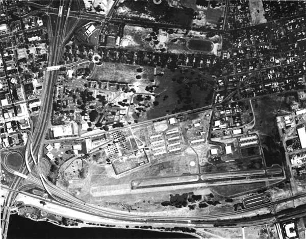
| This recent aerial photograph of Fort Vancouver clearly illustrates the close juxtaposition of Pearson Airpark with the Historic site. Officers Row is situated to the north and Interstate 5 to the west, while Pearson's hangers and runway are on the east and south of the stockade. (National Park Service) |
Preservation of Pearson--the Late 1980s
In September 1986, at a regular City Council meeting, City Manager Paul Grattet recommended that no further efforts be made to support Pearson. Two councilmen, Dick Porkonowski and Bruce Hagensen, who was later elected mayor, disagreed with Grattet and voted to maintain Pearson. [98] The "Friends of Pearson Air Park" regrouped in November 1986 as The Pearson Airpark Historical Society (PAHS). At City Council meetings John Wulle actively promoted "Pearson as the proposed home for a new air museum, and also stressed that the airport should be kept open because it serves as a desirable buffer against air traffic from Portland International Airport." [99]
The following year, City Manager Paul Grattet again recommended abandoning the airport property, even before the right of use expired in 2002, and suggested reconsidering the "Pioneer" site for a county airport. [100] However, on March 9, 1987, the City Council resolved to "keep Pearson operating indefinitely" and, in recognition of the Pearson Airpark Historical Society, establish a museum at the airport. In order to accomplish this it suggested compromising with the National Park Service needs and relocating "some of the aviation buildings to the east side of the airfield [to] reduce the visual intrusion on Fort Vancouver," while the runway and adjoining taxiway would remain active. [101] The city realized that congressional approval was needed in order to develop this alternative.
In response to the city's resolution, the Park Service Pacific Northwest Regional Office created a task force to study possible use of the Pearson property after 2002. Headed by Regional Deputy Director William Briggle, the task force members, including Regional Office staff Richard Winters, Stephanie Toothman, Wendy Brand, and Harlan Hobbs, visited Fort Vancouver in June 1987 to review the Pearson issue. [102] They concluded that "the park strongly supports proceeding with the concept outlined in the Master Plan of restoring a sense of the historic scene by planting the Pearson Airpark property in various field crops after the City's rights expire in 2002." Richard Winters suggested that the National Park Service demonstrate the strength of its commitment to this position--"to enhance the visitor's understanding of this nationally and regionally significant historic site"--and produce a development plan for the property. [103]
Now mayor, Bruce Hagensen continued to promote the city's commitment to retaining Pearson. At a July 1987 meeting with Congressman Donald Bonker, the mayor stated that the city favored Pearson "remaining as a functional airport with the current level of use and retention of the paved runway." [104] In January 1988, the City Council passed Resolution M-2595, approving the Pearson Airpark Master Plan.
In an attempt to find some compromise position between the city and the National Park Service, Park Service Regional Director Charles Odegaard developed a Statement of Alternatives which was presented to members of various interest groups on May 5, 1988. Out of five basic alternatives, the Park Service preferred one which was reminiscent of the "historically integrated alternative" of the 1985 Pearson Airpark Master Plan. The Park Service would help the city establish an aviation museum, allowing "limited operations on NPS property, including rehabilitation and use of the historic pilots' lounge and hanger, and exhibition of antique aircraft." Occasional use of a grass strip for landing of aircraft would also be accommodated. [105] Though the regional director's proposal addressed the concerns for commemorating aviation history, the city insisted that it could not have the historic airpark museum without the commercial air operation at Pearson. [106] At a meeting with city officials in July 1988, Regional Director Charles Odegaard confirmed that "the agency will help develop an air museum on park property and allow occasional use of grass fields by antique aircraft, but no continued use of Pearson for commercial and general aviation." [107]
John Wulle, representing the Pearson Airpark Historical Society (PAHS), joined the city in insisting that "this organization can not and will not go forward with the museum without an agreement between the city and NPS which continues Pearson as an airport." [108] In the fall of 1988, PAHS instigated a letter-writing campaign to the Park Service and the Washington State congressional delegation in support of maintaining Pearson as a commercial airport. However, the group continued to decline the Park Service's offer to establish and support an aviation museum and historic airpark. [109]
In closing this phase of the discussions, Charles Odegaard wrote to both Mayor Bruce E. Hagensen and John P. Wulle in October 1988, asking
that the Society reconsider its position of July 26, 1988, which conditions its interest and support for an air museum contingent upon the continued operation of Pearson Airpark....Should the Society choose not to reconsider its position and subsequently meet with us or should the Society reconsider and then decide to withdraw from Pearson, I respectfully request notice at your earliest convenience. [110]
The regional director further expressed his concerns as to why the city or other interested groups never explored "repurchasing the rights acquired by the federal government in 1972." The only conclusion he could make was that Vancouver expected "a free land grant be made from a national historic site for continuing a small local airport facility." [111]
Jolene Unsoeld and the Historical Reserve Concept
Since Representative Don Bonker had not supported extension of Pearson Airpark's use beyond 2002, PAHS did not get very far in its attempt to obtain congressional changes to the 1972 deed. However, in the fall of 1988, a new representative, Jolene Unsoeld, was elected from the Third District and decided to reexamine the issue.
Early in 1989, Representative Jolene Unsoeld met with Regional Director Charles Odegaard and Vancouver Mayor Bruce Hagensen. Subsequent to this meeting, Unsoeld requested draft legislation to develop a new master plan for the Vancouver area to "protect and enhance" Fort Vancouver National Historic Site, Officers' Row, and Pearson Airpark. The legislation included the continuation of general aviation at Pearson beyond the year 2002, the integration of the three historical themes in the area, and creation of a military museum at the Vancouver Barracks. [112]
For Pearson Airpark, 1989 brought mixed blessings. On one hand, two major tenants were $20,000 behind in rent. Ted Brown, of Vancouver's Parks and Recreation Department, professed that the Airpark "has a long history of businesses who are behind in rent." [113] On the other hand, the federal government continued to support development of small airports. In November 1989, George Bush signed a transportation bill which directed the FAA to give priority to Vancouver's request for $95,000 to pay for resurfacing the runway and extending the taxiways and security fence. Since FAA regulations prohibited "use of federal money on any public airport unless it is going to continue to operate for 20 years or more," the act committed Congress "to keeping the airport open beyond the year 2002." [114]
Perhaps because of the new optimism in finding a congressional solution to the impending closure of Pearson Airpark, the Clark County Commissioners suspended efforts to locate a county airport at the Pioneer/Ridgefield site, despite the FAA's desire to keep that option open. In March 1990, the FAA urged Paul Grattet, the Vancouver city manager, to continue to support the development at Pioneer because the new airport was needed. [115]
In June 1990, a year after its original inception, Representative Jolene Unsoeld again introduced legislation to establish a Vancouver National Historical Reserve. The legislation sought to establish a cooperative agreement and a Coordinating Commission to manage the Reserve which would include Vancouver Barracks and Military Cemetery, Officers' Row National Register Historic District, Fort Vancouver National Historic Site, Pearson Airpark, and the Columbia River waterfront. Within this Reserve, general aviation would continue at Pearson Airpark beyond the year 2002. [116] The National Park Service opposed the legislation because it would prevent Fort Vancouver from restoring the cultural landscape surrounding the reconstructed fort site.
Though an attempt to place Pearson on the National Register of Historic Places failed in October 1990, on November 5, 1990, President Bush signed into law a bill (H.R. 5144) that created the Vancouver Historical Study Commission. The Commission was established to study the historic, cultural, natural, and recreational significance of resources in the Vancouver area and to determine the feasibility of a historical reserve. [117]
The establishment of a historical reserve is still uncertain. To date, the Commission has met monthly and wrestled with both the questions of managing a Reserve as well as recommendations for the fate of Pearson Airpark. The Park Service recently offered a compromise to the city which would allow the extension of general aviation until the year 2022 and the eventual conversion of Pearson to a historic airfield. However, this extension may only delay the ultimate decision which needs to be made: will the Park Service retrieve and develop its property according to its current master plan? Or will the participants arrive at a workable compromise that allows Pearson Airpark and Fort Vancouver National Historic Site to coexist?
| <<< Previous | <<< Contents>>> | Next >>> |
adhi/chap6.htm
Last Updated: 02-Feb-2000