|
FORT LARNED
Master Plan |

|
VI. THE PLAN
Limiting factors are involved with the ultimate development goals for Fort Larned which demand certain interim solutions. Immediate action plans will initiate trends and guidelines that will eventually meet the desired ultimate goal. Factors include, but may not be limited to: (1) inadequate or incomplete archeological and historical knowledge necessary to determine original structural detail, (2) county highway improvement plans for the Pawnee River Bridge, (3) budgetary limitations, and (4) structural deterioration of the existing nine buildings.
Interpretation
This western military post, unique in its high percentage of original historic fabric, provides a wide variety of interpretive possibilities. The nine stone buildings, combined with restored native prairie surrounding the quadrangle, offer a realistic setting for recreating the historic scene. Overall, the interpretive program should place Fort Larned in the context of westward expansion and define the Fort's highly significant role in the development of the trans-Mississippi West.
The visitor center, located in Historic Structure No. 1 (HS-l), will serve as the focal point for information, orientation, and interpretation. Exhibits and audiovisual programs will provide an understanding of the events leading to the establishment of the Fort and the story of the Fort itself—from its inception in 1859 to the present day.
The following major roles of the Fort are listed in order of descending priority:
1. As guardian and major way station on the eastern segment of the Santa Fe Trail, 1859-72, prior to the construction of the Santa Fe Railroad.
2. As command post and operations base for U.S. Army control and pacification of the Southern Plains Indians, 1859-69, and the ethno-history of the Indians affected, especially the Southern Cheyennes and the tribes native to the area now included in the State of Oklahoma.
3. As outpost of government, culture, and law and order serving the first settlers in south-central Kansas, 1870-78.
4. As a force during the post-military period, 1878 to the mid 1900's, in the development of the immediate surroundings.
Numerous subthemes, such as soldier life, the post sutler, campaigns, trail ruts, and the later farm and ranching period, will be developed.
A tour of the Fort itself will be the highlight of the interpretive program. Visitors will have an opportunity to see all nine stone buildings restored to their exterior military appearance. Interiors will be restored when research provides acceptable accurate information to properly interpret specific facets of the story. This restoration will include partial or total refurnishing, depending on the particular building in question. All or parts of several buildings will be used on an adaptive restoration basis such as HS-1 as a visitor center, part of HS-5 for the water system, and one-half of HS-9 as a study collection storage area and a conservation workshop.
As mentioned before, Fort Larned lends itself to various types of interpretation: well-planned living history demonstrations and visitor introduction to the historic environment; traditional guided tours; self-guided walks; wayside exhibits; and message repeaters. The overall interpretive plan should not restrict interpretation to a specific technique. It should allow for a degree of freedom in which the interpreter can use imagination and initiative to fit the need of the visitor and the preservation of the Fort.
|
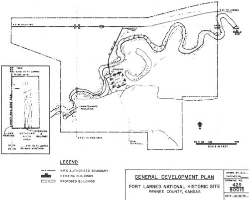
| General Development Plan. (click on image for a PDF version) |
Development
All of the existing structures are to receive exterior rehabilitation and restoration to return them to their appearance of the late 1860's, the time of their construction. The Barracks, HS-1, has received this exterior treatment as well as a finished interior for adaptive use for administrative and visitor purposes. In addition to staff office space, there is also a visitor contact area, museum, restrooms, and audiovisual facilities. No interior historic or traditional use is contained in this structure, but conversely no modern uses, with exceptions as later noted, will be housed in any of the remaining buildings.
The interior of the second Barracks, HS-2, will be restored in two sections. Although originally the east half had been a cavalry barracks and the west half an infantry barracks, the cavalry troop only occupied the Fort from April 1867 to January 1869. The hospital later occupied the vacated cavalry portion. Except for differing uniforms and personal accouterments, the cavalry section would be identical to the infantry quarters. Therefore, the hospital will be restored and refurnished in the east half of the building and the infantry barracks will occupy the west portion of HS-2.
HS-3, the Shops Building, will receive exterior restoration, as previously noted, as well as interior restoration to the extent that existing data permit without imposing any conjectural inaccuracies. As information may become available, additional interior work will be accomplished, but for now, only the walls, floors, ceiling, and the forge will be restored. Exhibitry will be added to interpret the structure's use during the Fort's occupation.
HS-4, the New Commissary Storehouse, is scheduled for adaptive use as a temporary maintenance shop to support preservation work on the historic structures. If research data become available, the schoolroom of the 1870's, in the north end, will be restored and refurnished. For the present, enough information is not available for any interior restoration. The building, therefore, will continue as presently utilized with restrooms in the south end and the remainder devoted to the maintenance facility.
HS-5, Old Commissary Storehouse. Information sufficient to restore the interior of this building is not currently available. The ultimate goal for this building is complete restoration and refurnishing. This will be undertaken if sufficient data are developed to permit restoration and refurnishing with a minimum of conjecture. Until that time, the interior will continue its adaptive use with the pumproom and water supply system in the east end, and storage in the remainder of the building.
HS-6, Quartermaster Storehouse. Available knowledge permits restoration of interior walls, floors, and ceilings. To restore the interior doors and all partitions would involve considerable conjecture and will not be undertaken at this time. Restoration of a portion of the interior at this time will permit interpretation to convey the magnitude of supplies on hand at the Fort. The remainder of the structure will be either utilized for storage purposes or stabilized and left vacant. If sufficient data are developed in the future to permit accurate interior restoration and refurnishing, this will be undertaken.
HS-7, Officers' Quarters. The interior of this building will be restored and refurnished as officers' quarters. Since the miliary occupancy, alterations have been minor and sufficient data now exist to effect this restoration. Although no furnishings exist, the necessary interiors will be based on Victorian quarters scaled to a military post setting for two captains' and four lieutenants' apartments. Archeological evidence has indicated that the Post Surgeon had quarters in this building, and this is a possible use for one apartment.
HS-8, the Commanding Officer's Quarters, is presently in adaptive use as quarters for the park historian. Management, however, has determined that onsite employee quarters will be eliminated. One of the adjunct purposes of these quarters was off-hours protection of the Fort. This job will, in the future, be performed on a contractual basis utilizing on-foot patrolmen during hours of darkness. Information is now available to permit architectural restoration of the interior with little or no conjecture. There is insufficient evidence, however, for refurnishing so interpretation will be accomplished through exhibitry.
HS-9, Officers' Quarters, will be restored and refurnished in the south half to reflect the domestic environment of company-grade Army officers. The greatest proportion of interior historic fabric of any of the Fort's structures remains in this structure. Therefore, HS-9 requires the least restoration. The north half will be adapted for curatorial workspace and storage.
HS-10, the Blockhouse, will receive interpretation both at its original location as well as in the museum. Enough information is not available at this time to reconstruct this structure. If sufficient data become available, and if the structures's significance is considered essential to the essence of Fort Larned, the blockhouse will be reconstructed.
HS-32, the Flagpole, will be reconstructed.
The remainder of the non-existing historic structures and features will be identified, preserved, and interpreted. Further archeological research will be conducted where appropriate.
|
| Visitor Access (interim). (click on image for a PDF version) |
|
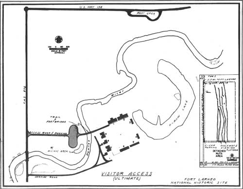
| Visitor Access (ultimate). (click on image for a PDF version) |
Visitor Access and Parking
The present access will be retained. Visitors enter the Historic Site on State Highway Spur 242, a 1/4-mile paved road that includes a full-width two-lane concrete bridge over the Pawnee River. Parking is at the northwest corner of the parade ground immediately west of HS-1. This is not the most satisfactory solution, but will be adequate until completion of all restoration throughout the Fort.
At that future date, efforts will be made to obliterate the spur and bridge with the new entrance road located at the county road along the western boundary, a parking area on the north side of the river, and pedestrian access over a foot bridge to the Fort's northwest corner.
Maintenance Facilities
All maintenance facilities will be relocated from the immediate Fort environs and housed in one or more new structures west of the county road at the extreme western edge of the Historic Site to eliminate, as nearly as possible, sound, visual, or air pollution caused by modern equipment uses or repairs.
Staff Housing
The termination of staff housing in HS-8 will be accomplished when restoration of that structure is started and should concide with the start of nighttime contract guard service.
|
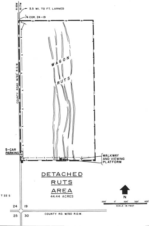
| Detached Ruts Area. (click on image for a PDF version) |
Santa Fe Trail Ruts
A Range Management Study will be undertaken to determine management practices to restore the native vegetation. The observation platform will be relocated further east where the ruts can be more readily discerned. A trail will be provided to the platform from a five-car off-road parking area at the southwest corner of the rut area.
Parade Ground, Company Streets, and Landscape Features
These features will be restored or reconstructed as the findings of archeological and historical research dictate.
Native Grass Restoration
Since 1968, this has been an on-going project in an effort to recreate historic vegetative prairie cover. Today, only 25 acres remain to be seeded with native grasses. The rest of the land has been seeded and is in various stages of succession to native vegetation. Continued intensive management for the next three or five years should produce the desired vegetative cover.
Water Supply
The water system at Fort Larned, fed by a well south of HS-5, is wholly park owned and maintained. Water is pumped from the well and stored in an underground 100,000-gallon fire reservoir and a 3,000-gallon domestic tank. There is a pumproom in HS-5 where pressure is generated, chlorination is accomplished, and provision for priming an eight-hydrant fire system for protection of the Fort is provided. Domestic water is supplied to buildings HS-1, HS-4, HS-7, HS-8, and HS-9.
Water Rights
Within the immediate vicinity of the Historic Site, the Pawnee River has a channel capacity of 4,000 cfs. Records available indicate extreme flows vary from virtually dry to a flood stage of 16,300 cfs. During the early 20th century, a concrete dam was constructed about one-quarter mile below the present Site boundary.
The riverbanks are diked. This impoundment backs water through the Site and for about six miles upstream. The river silted the impoundment, raising the stream bed and water surface some 12 to 14 feet above their historic level immediately above the dam and approximately seven to nine feet above historic level adjacent to the nine remaining buildings. This has extensively altered the appearance of the immediate river environment, but to what extent it affects the preservation of the historic structures has not been determined. As part of the water rights (2,000 acre-feet per year at 6,500 gpm) associated with the dam and still held by a private owner, the dry oxbow within the Historic Site is closed at either end by earth dams. The oxbow was last filled from the river by means of pumps in 1974. When it is filled, instead of the grassy and wooded depression that existed historically, the oxbow becomes a stagnant pond that adversely affects the appearance of the Site. The pumping plant for the water right exists within the Historic Site on the south bank of the river west of HS-7, and ditches and dikes traverse the area.
These water rights will be negotiated and acquired as soon as feasible. When this occurs, the National Park Service will seek alternatives to remove the dam and restore natural drainage patterns within the Historic Site.
| <<< Previous | <<< Contents>>> | Next >>> |
master_plan/sec6.htm
Last Updated: 14-Aug-2009