|
FORT LARNED
Master Plan |

|
IV. CULTURAL RESOURCES
Significance
Fort Larned was first established in 1859 as Camp on Pawnee Fork, and renamed Camp Alert the following year. In 1860, the Army relocated the camp to its present site, three miles west of the original location, and renamed it again, this time in honor of the Paymaster General, Colonel Benjamin F. Larned. Fort Larned became a focal point for relations and conflicts between Indians and non-Indians on the Plains during and after the Civil War.
The post was established because of Indian displeasure at increasing traffic on the Santa Fe Trail. Its mission was to protect the Kansas portion of the trail, and in concert with Fort Lyon, Colorado, and Fort Union, New Mexico, Fort Larned was a principal element in a system of posts and patrols intended to insure the safety of travel, commerce, and the mails in the face of Indian opposition.
The Fort was for more than a decade a base for operations against Indians on the Central Plains. The tribes included the Cheyennes, Kiowas, Arapahos, and Comanches. Also during the 1860's, Fort Larned was the focus of a program of peaceful conquest. From 1861 to 1868, the Fort was the Bureau of Indian Affairs distribution point for annuities received by tribes which signed the Fort Wise Treaty of 1861. In 1864, Fort Larned became the agency for the Kiowas and Comanches, and, the following year, for the Cheyennes, Arapahos, and Kiowa-Apaches. The agency was abolished in 1868, when the tribes were moved to reservations in Indian Territory.
During the 1870's, troops from the post provided protection for the construction of the Atchinson, Topeka, and Santa Fe Railroad. Upon completion of the line through Kansas in 1872, the Fort provided police service in the area until it was abandoned in 1878. A guard detachment from Fort Dodge protected the property until 1883, when custody of the Fort Larned Military Reservation, declared surplus, was transferred to the General Land Office, Department of the Interior.
Fort Larned had undergone a major construction program in 1867-68, and much of its significance lies in its architectural features and their unity as a complex.
Although only nine of its historic structures survive, they are among the most substantial built there. They comprise all but one, a frame adjutant's office, of the ten structures that originally defined the parade ground quadrangle and are good examples of American military post architecture during the Victorian period. Remains of virtually all other structures built by the Army survive as archeological features. Although of somewhat less importance to the area's significance, the remains of the non-existent historic structures nonetheless represent facets of the Fort's history and contribute to its importance and significance as a historic resource.
Sold at auction by the General Land Office in 1884, Fort Larned passed through the hands of several owners, most of them headquarters of agricultural concerns. The Fort site, including the buildings, was finally purchased by E. E. Frizell in 1902 and remained in the hands of his family until its establishment as a National Historic Site. During the intervening period the surviving structures were preserved (most with extensive alterations) through adaptive use as the headquarters for a major ranching operation.
Fort Larned was studied by the National Survey of Historic Sites and Buildings, found to be nationally significant, and designated a National Historic Land mark in 1961. The Historic American Buildings Survey recorded the nine surviving historic structures in 1965. On August 31, 1964, the President signed Public Law 88-541, authorizing the establishment of Fort Larned National Historic Site.
In summary, Fort Larned's significance lies in the role it played in this Nation's history, but is also significant under National Register criteria because of this role as well as the fact that the Fort still has structures dating from the historic period. The resource for which the Park was established, therefore, is the nine extant structures comprising the present complex.
As a unit of the National Park System, Fort Larned National Historic Site is listed on the National Register of Historic Places. It is, therefore, afforded the procedural protection of Section 106 of the National Historic Preservation Act (80 Stat. 915).
In addition, compliance with 36 CFR 800, Executive Order 11593, and the Antiquities Act of 1906 is also required.
Historic Appearance
When the troops moved Camp Alert (renamed Fort Larned on May 29, 1860) in 1860, they established it on the south bank of the Pawnee River. In an area measuring about 800 feet east-to-west by 1180 feet north-to-south, the Army initiated a construction program. During its military history, Fort Larned consisted of a total of at least 50 structures, some of which proved exceedingly temporary. Those built in the early years were rudimentary. In 1860, troops erected seven structures of consequence: an adobe quartermaster storehouse and an adobe commissary storehouse (immediately north and parallel to the future sites of the present stone barracks); a partitioned officers' quarters of adobe and "pickets" (immediately south and parallel to the future site of the present stone quartermaster storehouse); a "picket" guardhouse (on the eastern fringe of the post, next to the bank of the dry oxbow); two adobe laundress quarters (immediately north of the two storehouses, near the river); and an adobe hospital (near the angle formed by the junction of the river and the oxbow).
The troops also built even more primitive structures. Their quarters and the post bakery were dugouts along the riverbank. A small adobe meat house, a log and canvas "carriage house," and a three-room "picket" shops building (these three along the river northwest of the present officers' quarters), supplemented with a miscellany of tents and hovels, constituted Fort Larned's physical plant during its early years.
The structures were better suited to the arid Southwest than to Kansas, particularly since most of them were roofed with earth-covered brush. In short order they were literally ramshackle. But, loosely arranged around a hollow square, they circumscribed the parade ground central to site planning in military posts at the time.
Its basic character thus established, Fort Larned received improvements prompted by official recognition of its physical dilapidation and tactical value. The first new development was a stone blockhouse (southeast of the southeast corner of the present parade ground), constructed in 1864-65. At about the same time, a line of field trenches was dug across the southern flank of the post from the river to the dry oxbow. The attention shown to such traditional fortifying works was a short-lived curiosity most evident in contemporary military posts in Kansas. Such trenches reflected the experience of officers during the Civil War, a conflict between modern armed forces capable of assaulting strongpoints. The Plains Indians, however, were insufficiently motivated and equipped, and not numerous enough to engage in such assaults and, accordingly, refrained from attacking military posts. Fort Larned and its contemporaries were quarters and storage facilities, rather than true forts, and in this they established patterns of site planning still followed in American military posts.
Despite some debate on whether or not Fort Larned ought to be moved to a new location, plans were initiated in 1866 for an improvement in the post's physical plant. During the summer and fall the troops constructed a stone commissary storehouse (the easternmost of the two sturctures now on the south side of the parade ground), which was completed and subjected to alterations the next year. Its walls were originally raised all around to about four feet, and at that level a series of rifle ports were built in as the walls rose to full height. This "fortification" effort supported General Hancock's decision to abandon and fill in the entrenchments, which were difficult to maintain and so lengthy that more than a thousand soldiers would be required to man them in event of a serious attack.
During 1867 and early 1868, a civilian work force averaging 191 men, under the supervision of an Army quartermaster, undertook a comprehensive construction program that was to provide six frame buildings, nine stone buildings, and alterations to two existing stone structures, the blockhouse and the commissary storehouse. After a reduction of funds in early 1868, only a minor amount of work—including the addition of kitchen wings to the two barracks, completion of the new commissary, and addition of porches to the officers' quarters—had to be completed by enlisted men under the supervision of a second lieutenant. One stone structure originally proposed, a new guardhouse, never progressed beyond its foundation.
In 1869, the cavalry stables constructed during the program (located south of the present commissary and quartermaster storehouses) burned to the ground. At about the same time, an extensive cleanup program was undertaken to remove construction debris and the remains of the surplus original structures from the Fort. If they had not been filled previously, the trenches were probably filled in during this effort.
From the end of 1869 until the close of its military occupation, Fort Larned's appearance remained essentially static. It included ten structures around the parade ground (the nine existing stone buildings and a frame adjutant's office at the northwest corner), together with the foundations of the uncompleted guardhouse on the east side of the parade; the blockhouse (converted to a guardhouse); the two laundress quarters and the hospital north of the barracks; a hospital steward's quarters near the northeast corner of the east barracks hospital; a washhouse near the northwest corner of the west barracks; an icehouse next to the river west of the commanding officer's quarters; the sutler's corral and stables next to the river south of the icehouse, with three sutler's buildings south of them; and the new sutler's store about one hundred yards south of the quartermaster storehouse. The original cemetery was moved in 1869 from the island within the oxbow to a site north of the post on the opposite side of the river. The oxbow island was used for storage of wood, hay, and materials. A scattering of corrals, teamsters' quarters, miscellaneous structures, and a dump completed the scene.
In the period immediately following its abandonment, Fort Larned deteriorated in a gradual process aided by scavenging of materials from the structures. During the ensuing eight decades, the place again came to life as a ranchstead. New structures including silos and corrals were added and all but the nine surviving stone structures around the parade were demolished. Those that did survive were variously altered for utilitarian purposes. The two barracks, for example, became a single, large barn covered with an enormous gambrel roof. Fences were added and shade trees and decorative vegetation took root. By 1960 the ranch evinced stylish and comfortable prosperity in a unique layout provided by the Army's site planning and architecture.
Since the late 1960's, a program has been underway to restore the military appearance of Fort Larned's remains. During the 1960's most added ranch structures were demolished and the detritus of the ranching period removed. Only the nine altered stone structures built by the Army remain.
|
| (click on image for a PDF version) |
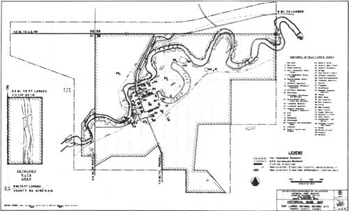
Existing Historic Structures
Nine historic structures, all of stone and all but one constructed during the 1867-68 program, survive from the period of Army occupancy at Fort Larned. They are described below in order according to Historic Structure (HS) numbers assigned by the National Park Service. The sequence is arranged clockwise around the parade ground, beginning at the northwest corner, for existing structures and continues without reference to the parade ground for structures no longer existing.
HS-1, Barracks: This T-shaped building was constructed in 1867-68, and the kitchen wing was added in 1868. The main structure measures 150 feet (E-W) by 43 feet (N-S). The kitchen wing measures 36 feet (E-W) by 34 feet (N-S) and projects from the center of the north (rear) facade. The structure had coursed rubble stone masonry walls, gabled roof, and a rubble stone masonry partition, without openings, divided it into an eastern and western half. The partition was continued without openings in the kitchen wing. The structure constituted, therefore, two separate company quarters under the same roof.
During civilian occupancy, the structure was converted to use as a barn. In 1929, HS-l and HS-2 (the other barracks) were converted into a single barn.
The walls were raised (in salvaged stone) about five feet, the gables removed, and a large gambrel roof—reputedly the largest in Kansas, possibly one of the largest in the country—was constructed, partially from materials salvaged from the original roofs. In 1973-74, restoration of the exterior of HS-1 to its military appearance was largely accomplished. Adaptive interior restoration of this structure was completed in February 1977, permitting the structure to be used for office, audio-visual, museum exhibits, and public restroom facilities.
HS-2, Barracks: This T-shaped building is the easternmost of the two structures on the north side of the parade ground. It was constructed in 1867-68 and the kitchen wing was added in 1868; HS-2 is nearly identical to HS-1. The larger eastern wing was intended for the one company of cavalry stationed at the post from April 1867 to January 1869, but in 1871 that wing was converted to a hospital. The barracks room was partitioned into two wards, and counters, shelving, and other medical storage facilities were installed in the various rooms.
Other construction details, interior and exterior finish, alterations, and subsequent exterior restoration, are the same as for HS-1.
HS-3, Shops Building: This rectanglar building is the northernmost of the two structures on the east side of the parade ground. It was constructed in 1867-68. It measures 84 feet (N-S) by 30 feet (E-W) and has walls of coursed rubble stone masonry, gable-roofed at the ends. Because of a great number of post-military alterations, it has been difficult to identify all aspects of the structure's military appearance. On the basis of historical, archeological, and architectural research, the building apparently fronted to the east, away from the parade ground. There was a brick and stone chimney at each end of the structure and one at the partition between the center two shops. Other interior details have been more difficult to determine. It is known that there were four rooms separated by framed partitions.
Beginning at the north end there was a two-room bakery with one oven; a saddler's, carpentry, and wheelwright shop; and a blacksmith shop. All but the blacksmith shop evidently had wood floors.
During civilian occupation, the structure was connected to HS-4 by a long metal shed, and the roof was covered in metal. In the 1930's, the former bakery was converted to a storage space and the remainder to machine shop and storage. In the 1950's, a blacksmith shop was opened in the former blacksmith room for interpretive purposes. The structure has not been importantly altered since.
HS-4, New Commissary Storehouse: This rectangular building is the southernmost of the two structures on the east end of the parade ground. It was constructed during 1867-68. It measures 84 feet (N-S) by 31 feet (E-W) and has walls of coursed rubble stone masonry, gable-roofed at the ends. There were two stone chimneys, one at the north end and another about 20 feet from the south end, as gauged from historic photographs. The remainder of the interior was a storeroom without a ceiling. The structure was intended for additional commissary storage. During the 1870's, the north end of the building was used as the post school.
During civilian occupation, in the first two decades of the 20th century, the structure was gutted, provided with a new metal roof, and joined to HS-3 by a long shed. Once a ranch machine shop, during the 1950's the interior was used to house visiting youth groups. A single wood door with stone stoop was cut into the west elevation at the south end, and men's and women's restrooms were installed in that end. The remainder of the structure was converted to use as the park maintenance shop, a use that still prevails. The metal roofing was replaced with wood shingles in 1968, following accidental destruction of the roof.
HS-5, Old Commissary Storehouse: This rectangular building is the easternmost of the two structures on the south side of the parade ground. It was constructed in 1866, measures 154 feet (E-W) by 27 feet (N-S) and has walls of coursed rubble stone masonry, gable-roofed at the ends. There is a row of rifle ports in the west and south walls. There were two stone chimneys, one about a third the length of the structure from each end. Interior finish probably included shelving and bins and two or more frame partitions, but there is incomplete evidence on details. In the first two decades of the 20th century, civilian owners converted the building to a stable with the windows on the north elevation converted to stall doors. The north wall was connected to the north wall of HS-6 with a stone masonry wall and the connecting space roofed with metal roofing on a wood frame, affording a garage open to the south. The roof of the structure was at some time replaced with metal roofing. Stalls were constructed in the interior. In the 1950's a "saddle shop," since removed, was installed in the west end for interpretive purposes. The pumproom and tank for the park's water system are in the east end of the structure today.
HS-6, Quartermaster Storehouse: This rectangular building is the westernmost of the two structures on the south side of the parade ground. It was constructed during 1867-68 and measures 158 feet (E-W) by 40 feet (N-S). There is a row of rifle ports at about the four-foot elevation of the south wall. In the interior, a frame partition ran across (N-S) the structure about 30 feet from the west end, and the intervening space was bisected by another frame partition from that to the west end just north of the door. The northwest room was further subdivided into an office and another room (possible quarters), while the southwest room was an issuing room with access to the remainder of the structure—the storeroom—through a door in the partition.
The structure was joined to HS-5 by a stone wall connecting the north walls of each structure. This was covered with a metal, wood-framed roof that afforded a garage open to the south. The interior was altered for barn purposes, with stalls and storage facilities, removing part of the evidence of original partitions. It is now used for storage.
HS-7, Officers' Quarters: This U-shaped building is the southernmost of the three structures on the west side of the parade ground. It was constructed during 1867-68 and measures 84 feet (N-S) by 54 feet (E-W) overall, with walls of coursed rubble stone masonry. The structure was a duplex, bisected by a continuous 34-foot-long stone partition running east-west at the center. The main portion of each half included four rooms divided by frame partitions, separated in pairs by a central hallway seven feet wide. The outer pair of rooms in each half was a two-room apartment for a captain. The interior pair of rooms in each half were one-room apartments for lieutenants and each opened onto the hallway. Each hallway ran between a front door and a rear door, and each kitchen wing. There were two rooms in each kitchen wing, a servant's room and a kitchen opening onto the porch. There was a cellar underneath each kitchen wing, accessible by both interior and exterior stairs. In 1869 each cellar was deepened and converted to a kitchen, with the former kitchen converted to a dining area. A porch ran the length of the structure on the front, supported by square wood columns with balustered rails and sawn wooden brackets. There were three brick chimneys on the main structure and one on each kitchen wing. In 1869-70 one or two four-room frame additions were provided to give each pair of lieutenants a kitchen, dining room, and servant's quarters.
The structure generally preserves its historic fabric, as alterations have not been extensive. It has been used as a residence since the military left it. Modern utilities have been installed and a bathroom was added in the 1950's. Appurtenances, including all outbuildings (privy, kitchen house, fences, etc.) that existed in the military period were removed by the early 20th century, although a stone-lined well still remains at the rear of the quarters. The front porch has been replaced with a concrete platform, although columns and porch roof were retained.
HS-8, Commanding Officer's Quarters: This L-shaped building is the center of the three structures on the west side of the parade ground. It was built in 1867 and measures 47 feet (N-S) by 63 feet (E-W) overall, and is constructed of finely dressed ashlar stone masonry on the front (east) and both sides, with coursed rubble stone masonry on the rear (west) side. There were three brick chimneys, one at each end of the main structure, and one at the rear (west) end of the kitchen wing. There is a porch at the middle of the front elevation. The interior of the main portion was divided into four equal rooms separated in pairs by a central hallway running between the front and back doors. The kitchen wing had only one kitchen room with pantry closet. The only second-story room at the Fort, a servant's quarters, was immediately above the kitchen.
During civilian ownership in the 20th century, the structure was extensively altered but remained a residence. The interior and exterior alterations date principally from the 1950's. All outbuildings and appurtenances were removed in the early 20th century, although the well and privy liners (stone) remain and are covered. The structure is presently used for employee quarters.
HS-9, Officers' Quarters: This U-shaped building is the northernmost of the three structures on the west side of the parade ground. It was built in 1867-68; one or two kitchen additions were added in 1869-70 (as for HS-7). It is nearly identical to HS-7. While its alterations in the 20th century include two bathrooms—one on each kitchen wing porch—as opposed to the single unit added to HS-7, the interior and trim of HS-9 appear to retain a greater proportion of original historic fabric than any other structure in the Fort. The structure presently houses the Fort's curatorial facility. All appurtenances and outbuildings were removed in the early 20th century, although the stone well liner remains and is covered.
Historic Structures No Longer Existing, and Other Historic Structures and Features
During its military existence, Fort Larned saw the construction and demolition or abandonment of a wide variety of structures, most of them buildings of various sorts, but including the parade ground, gardens, dumps, and a drainage system. The most familiar of these structures was the Blockhouse (HS-10). This was located about 100 feet southeast of the south end of HS-4, towards the curve of the dry oxbow. It was constructed in 1864-65. Its six walls were of coursed rubble stone masonry with two rows of rifle ports all the way around, one about three to four feet from the ground and the other about two feet from the top of the 12-foot walls. A wood-walled tunnel ran from the interior of the structure 16 feet northwest to a covered well. The structure was white-washed after 1871. Interior details can only be conjectured, since the structure was demolished before the turn of the century. The structure was originally intended for use as a blockhouse, but the need for such a defense never arose. During the first few years of its life it was used for storage of supplies. In 1867 it had been converted to a guardhouse, with prisoners housed in the interior.
Archeological investigation was undertaken in 1974 and revealed the existence of the ground plan, the tunnel, and the well, together with some debris. The excavation has been backfilled and the site is marked on the surface.
Santa Fe Trail Ruts (Detached Area)
This 44.44-acre stretch of ground is located approximately four miles southwest of Fort Larned. It preserves examples of the ruts caused by wagon traffic over the Santa Fe Trail. Because of this importance it has never been plowed, being held intact as a small pasture surrounded by croplands by its previous owner until its acquisition by the Federal government after the establishment of the National Historic Site. The gently rolling terrain is broken by the longitudinal depressions of the trail ruts and by the remains of a few buffalo wallows. The vegetative cover is a remnant of original prairie vegetation, altered due to long-term grazing. A raised platform, near the center at the south end, provides an elevated view of the area.
| <<< Previous | <<< Contents>>> | Next >>> |
master_plan/sec4.htm
Last Updated: 14-Aug-2009