|
Effigy Mounds
Administrative History |

|
Chapter Seven:
DEVELOPING THE NATIONAL MONUMENT
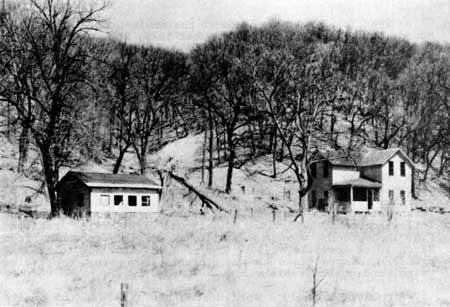
When Joe Kennedy arrived at the newly-proclaimed Effigy Mounds National Monument in November 1949, the only potential facilities were an abandoned fifty-year-old farmhouse that had never been wired for electricity or piped for water, an old chicken coop that provided a home for a number of black snakes, a shabby barn and two equally tumbledown sheds, and a ninety-five-foot deep well which was in poor condition. An illegal dump existed across the Yellow River from these humble structures. There were no trails, signs, fences, driveways, parking areas, nor comfort station. There was not even a space suitable for Kennedy's use as an office. Certainly, much work needed to be done.
Kennedy immediately razed the more dilapidated of the two sheds and cleaned and painted the other. By the end of February 1950, he arranged for contractors to rehabilitate the farmhouse for his family's use. Work on the house began the following month, supervised by National Park Service Architect F.R. Robertson, who was stationed at the monument from March 20 to April 15, 1950. Progress was slow due to funding problems, distractions such as a brush fire nearby, oppressive rains, and other problems. [1]
Much of Kennedy's work during his first months onsite was geared toward making the farmhouse habitable. This included arranging to have the house serviced with utilities. The shortest course for tapping into existing electrical lines involved running cables across the neighboring Liebhardt land, but the Liebhardts refused to permit the line to cross their property, so the Rural Electrification Association ran it along the highway. The longer route increased the cost of the installation, but Kennedy persuaded other area residents to add electrical service at the same time, thus reducing the total cost to the National Park Service. [2]
|
| Figure 16: The farmhouse and chicken coop at the headquarters area, as it appeared when Superintendent William J. ("Joe") Kennedy arrived at Effigy Mounds National Monument in 1949. Photography unknown [probably Joe Kennedy], Negative #2, Effigy Mounds National Monument. |
Work to make the area liveable continued throughout the spring. Workers pumped out the well, razed the barn, and converted the chicken coop into a tool shed. Regional office personnel provided designs for water and sewage systems. It took two men two days to scythe the tall grass and weeds between the house and the highway.
On the first of June, the Kennedys' landlord asked them to move out of the rental house in McGregor; their son was getting married and needed the house for himself and his bride. At the time, the farmhouse at the national monument still lacked electricity, water, and a sewer system. Following some frantic activity, the house was readied and the Kennedys moved in on July 7, 1950. [3]
Shortly before the Kennedys took up residence at the monument, the Service constructed a gravel driveway with access from State Highway 13, [4] a twenty—car parking area, a road (much of which followed an existing track to a farm located adjacent to the national monument's west boundary), and a rough trail to the mound group at Fire Point. Workers scythed the mounds along the trail and sprayed an exfoliator to clear the view at Fire Point. The state highway department cleared away the trash dump on the south side of Highway 13. [5] The following summer, Kennedy accomplished some modifications to the trail and erected a chain link fence at Fire Point to prevent visitors from falling off the bluff top. [6]
The National Park Service erected a flagstaff, and the flag first flew over the national monument on July 23, 1950. The first interpretive signs, one near the Little Bear mound directing visitors to Fire Point, and another at Fire Point warning visitors about the steep cliff, were erected about the same time. In late summer, the highway department filled a low area near a culvert to create a forty—foot wide entrance "road" to the monument, and Kennedy ordered his maintenance staff to construct a retaining wall to hold the fill in place. After long discussions between representatives of the National Park Service and the highway department, the state agreed to allow the Service to erect an entrance sign on the highway right—of—way. [7] On August 24, 1950, the Service erected a sign to mark the monument's entrance. [8]
By December, heavy snows eliminated visitation by the public and by regional staff members. Kennedy installed linoleum on the office floor of the new shed, spread gravel over the floor of the maintenance portion of the structure, and had the building wired for electricity. In the spring, Kennedy had concrete slabs poured in front of the new shed and chicken coop, and painted the outsides of the two structures. He also had windows installed in the coop, which became the visitor contact station. During clement weather, a tarpaulin tent was stretched out from the front of the chicken coop, and contact with visitors took place outside. [10]
A couple of cold northeastern Iowa winters demonstrated the need to insulate the superintendent's residence; insulation was added in 1952. [11] The Service painted the house exterior white with green trim and had telephone service installed in spring 1952; the interior of the house was painted the following winter. Oil heat was provided to the equipment shed/office building in November 1952. [12]
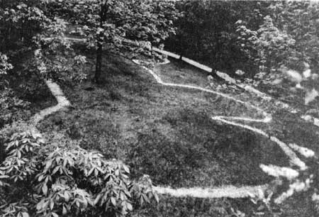
To make the south unit more accessible to visitors, the National Park Service removed some barbed wire fences and smoothed out an extant portion of the Old Military Road to facilitate transportation to the Marching Bear mounds. [13] Extremely heavy visitation during the fall 1951 color season showed the existing headquarters parking area to be grossly inadequate, [14] so the Service enlarged it to accommodate thirty vehicles. National Park Service maintenance workers improved the north unit's Fire Point trail and expanded it to one and one—quarter miles. For the first time the Service made an effigy mound, the Little Bear, more visible to the public by removing a two—foot—wide strip of sod from its base and replacing the grass with crushed white stone. [15]
In April 1953 the pump serving the headquarters complex broke and the drinking water was found to be unsafe for infants and pregnant women due to a high concentration of nitrates. The monument was without water for about six weeks while the pump was removed, repaired, and reinstalled. Even after the repairs, the water remained unsafe for infants. The National Park Service installed a new pump a few months later. [16]
Just as incredibly heavy thunderstorms delayed progress in the construction of temporary facilities in 1951, so similar storms in 1953 caused the Service to make many repairs to the existing limited development. The National Park Service installed a drain in the parking area to assist with drainage, and regravelled the lot and driveway. They also built slopes behind the shed and chicken coop to prevent those structures from washing away. The Service accomplished considerable repairs to trails and cleanup of storm damage. Kennedy ordered the planting of trees at the heads of gullies to deflect the heavy flow of water. In other areas, maintenance workers built small dams to check the flow. [17] Oddly enough, by September the problems caused by the spring's heavy rains were replaced by a late—summer drought. The extremely dry conditions caused rocks along the trail's edge to fall away, and the maintenance crew spent eight work days in September replacing the rock edging. [18]
The following year the monument's well caved in, leaving the area without water for drinking, fire fighting, or any other purpose. The National Park Service drilled a new, deeper well, which finally eliminated the nitrate problem which had made the water unsafe. Until the new well was completed, however, the superintendent and his family were forced to truck water into the monument in ten-gallon milk cans. [19]
By the mid-1950s, the temporary headquarters and preliminary development were complete. The north unit included the rehabilitated farmhouse which served as the superintendent's residence, the chicken coop adapted for use as a tool room and visitor contact station, a frame shed used for office space and equipment storage, and two pit privies. The complex had electricity, telephone service, and adequate water and sewage systems. There was a crushed rock 300-foot driveway leading to a thirty-car parking area, as well as 1.9 miles of graveled trail leading up to Fire Point and the Little Bear mound. There were no facilities in the south unit, although a segment of the Old Military Road had been cleared. [20]
|
| Figure 17: The Little Bear mound with the north unit trail in the background, ca. 1952. Negative #1062, Effigy Mounds National Monument. |
Simultaneous with completion of the temporary head quarters and other preliminary development, the Service pursued plans for permanent facilities. At the time, National Park Service Director Conrad Wirth favored the inclusion of the national monument as part of a Mississippi River National Parkway, an undefined entity under consideration as a unit of the National Park System. Others concerned themselves with the more realistic task of planning for the development of the existing national monument, and began preparing a master plan for the area. [21]
In the 1950s, National Park Service master plans assessed all the known facts about the park unit and addressed protection, use, and development needs related to management of the area.
A National Park Service master plan . . . consists of many maps and pages of written material covering every conceivable bit of information on an area, including its natural features, history and archeology, engineering, road construction, developments of all kinds, forest—fire protection, maintenance, and nearly everything that must be considered in planning the protection and development of a piece of land for public use. [22]
Unfortunately, inability to implement master plans was a Servicewide problem during and after the second world war, when funding of park development and maintenance was cut to a minimum while Congress diverted tax dollars to the war effort and the conversion to a peacetime economy. By the mid-1950s, the National Park Service was deeply concerned with the System's failure to accommodate adequately its own needs and those of visitors to the parks. A decade after the war ended, complaints about the nonexistent or dilapidated park facilities were common. Charles Stevenson, in his article entitled "The Shocking Truth about Our National Parks" [23] brought the problem to the attention of households across the nation by quoting National Park Service Director Conrad Wirth:
"It is not possible to provide essential services. Visitor concentration points can't be kept in sanitary condition. Comfort stations can't be kept clean and serviced. Water, sewer, and electrical systems are taxed to the utmost. Protective services to safeguard the public and preserve park values are far short of requirements. Physical facilities are deteriorating or are inadequate to meet public needs. Some of the camps are approaching rural slums. We actually get scared when we think of the bad health conditions." [24]
Wirth's concerns and popular interest generated a new thrust aimed at the implementation of park master plans, specifically at those aspects of the plans dealing with facilities development or rehabilitation. The program, known as Mission 66, was comprehensive and received full support from the secretary of the interior, Congress, and even the president. [25] Mission 66 provided the support and the impetus that in turn resulted in funding for much—needed development. Effigy Mounds National Monument's draft master plan could not have been completed at a more fortunate time.
Using the master plans as a base, parks Servicewide prepared prospectuses clarifying and/or modifying their master plan development schemes. The prospectuses reiterated the park's significance and management and development themes, outlined the park's management organization, and mentioned anticipated improvements which were not to be covered by Mission 66. The "meat" of the prospectus was a narrative outline of the Mission 66 development program.
The Effigy Mounds master plan, approved by Director Arthur E. Demaray in 1951, proposed the construction of an administration and museum building, two residences, and two single—hole pit toilets. [26] The Mission 66 Prospectus, drafted in 1955 and approved in 1956, built on the master plan and addressed such issues as visitor accommodations and services, conservation and protection of monument resources, circulation, utility systems, administrative facilities, employee housing, other physical improvements, and maintenance and management costs. [27]
The prospectus proposed several improvements for the national monument, including
. . . a visitor center on the site of the present headquarters area; a road into the south unit of the monument; a contact station and trail system at the Marching Bear mound group; parking area and scenic overlook along the bluff-edge north of the Marching Bear mound group, with a trail running north to a small but unique mound group on the bluff-top; and an expanded trail system in the north unit beyond the present Fire Point mound group trail. [28]
The prospectus further recommended construction of two residences for park employees, an overpass above Highway 13 and a bridge crossing the Yellow River, which would connect the proposed 135-car parking area with the south unit. [29]
There were major changes to these proposals in the late 1950s: The Regional Mission 66 Committee deleted the proposed overpass in 1955 on the grounds there was not enough anticipated traffic to justify the expense. The committee also deleted the proposed south unit overlook because similar views were available at Pike's Peak state Park, Iowa. See Acting Regional Director I. J. Castro to Superintendent [Berrett], August 10, 1955.
In 1958 Harvey Cornell, Supervisory Landscape Architect with the National Park Service's Eastern Office of Design and Construction, recommended reducing the parking area to a sixty—car lot with stabilized turf to accommodate overflow during the peak visitor season. Regional Chief of Operations George Baggley agreed with the suggestion. See Cornell to Berrett, January 31, 1958; and Baggley to Berrett, February 10, 1958.
The Mission 66 Prospectus assumed that eighty percent of future visitation would be in the form of vehicular tours of the south unit, with stops at the Marching Bear group and one or two scenic overlooks.
It should be noted that the proposed south unit development has been on and off until "finally" put to rest by Superintendent Tom Munson in 1972, who had it deleted from the monument's proposed development requests pending completion of a revised master plan. (See Superintendent Thomas Munson to Program Coordinator Lorraine Mintzmyer, April 28, 1972; and Acting Regional Director Merrill D. Beal to Superintendent [Munson], August 15, 1974.) That revised document, now known as a general management plan, is currently being prepared by a team of monument, regional, and Denver Service Center staff.
Assistant Chief Engineer L.M. Clauson of the Iowa State Highway Commission met with National Park Service Regional Director Howard Baker, Eastern Office of Design and Construction (EODC) Landscape Architect Harvey Cornell, and Region II Highway Engineer Barnes MacDonald to go over the master plan, and Clauson agreed to cooperate with the Service, as needed. A National Park Service request that the state provide a crosswalk and caution blinkers at the monument's entrance was rejected a year later because the state Highway Commission lacked legal authority to provide such services. [30]
Because commercial water and sewage facilities were not adequate to serve the proposed construction, the prospectus also recommended the construction of "a 50,000 gallon reservoir for water to be pumped from an existing well" and of sewage systems to serve the visitor center and residences. [31]
During the Mission 66 planning process, there was a conscious decision not to include campsites, picnic shelters and tables, benches, and fireplaces, because all of these accommodations were available at nearby Pike's Peak State Park, Iowa, and Wyalusing State Park just across the Mississippi River in Wisconsin. The Service also agreed there would be no need for concessions operations at Effigy Mounds National Monument because ample services were available in Marquette and McGregor, Iowa, and Prairie du Chien, Wisconsin, all located within five miles of the national monument. [32]
Prepared by the national monument staff, the Mission 66 Prospectus was thoroughly reviewed by regional office professionals and staff at the Service's Eastern Office of Design and Construction. EODC Chief Edward S. Zimmer, based on his review of a topographical map of the area, said the terrain north of Highway 13 did not appear to be suitable for the facilities proposed for that location. Zimmer expressed his further concern that the area was so cramped, expansion of the facilities, if needed in the future, would be impossible. He recommended placing the visitor center and parking area at the proposed Mississippi River overlook in the south unit of the monument, and constructing a contact station and parking area between the entrance north of Highway 13 and the proposed overpass. Zimmer further recommended that the contact station be the main visitor contact point during the winter months, when the remainder of the monument be closed off. He also advised that the residential-utility area be "located adjacent to but south of the state Highway, opposite the present headquarters area," a suggestion he believed even more important if the Service built the visitor center at the site of the existing headquarters, as proposed in the approved prospectus. [33]
Zimmer may not have been aware that the space south of Highway 13 was considered for headquarters development in 1953, when Thomas C. Vint was Chief of the EODC. In fact, EODC had promoted the area south of Highway 13 for years, but both the region and the monument preferred the scheme that was ultimately included in the Mission 66 Prospectus. Superintendent Berrett and the regional office staff rejected the area south of the highway because it did not provide enough space for the proposed facilities, nor did it allow for possible future expansion. Further, the park and regional staffs believed the flow of traffic was more logical as ultimately proposed in the Mission 66 Prospectus. [34] Thus, although Zimmer presented his comments on the recently approved Mission 66 Prospectus as though they were new objections based on data (the topographical map) only recently made available to the Service, in actuality he was repeating ideas raised by the EODC for several years. When informed the proposals would not be changed as per his suggestions, Zimmer accepted the Director's decision concerning most of the complex, but continued to argue for construction of the residences in the area south of Highway 13. [35]
While the Eastern Office of Design and Construction never agreed with the proposed layout of headquarters facilities, the monument and regional staffs never fundamentally disagreed. Although Regional Director Howard Baker favored a scheme which showed the overpass to the south unit at a location other than the one which Superintendent Berrett favored and Director Wirth approved, (a moot point, since the overpass portion of the plan was never implemented,) the regional and monument staffs agreed on the basic design, with one exception. Superintendent Berrett opposed the construction of a footbridge from the visitor center to the trail; he believed it was a waste of money, particularly since he expected use of the north unit to be severely reduced when the south unit was developed. On all other aspects of the design, the monument and regional staffs were in complete agreement. [36]
Mission 66 development at Effigy Mounds National Monument was initially scheduled to take place during the final phase of the program, or about 1964. Inquiries by Congressman Henry O. Talle -caused the Effigy Mounds projects to be moved to the last part of the first phase of Mission 66, with funding for the water and sewer systems and the paving project in 1959 and funding for the buildings the following year. With funding imminent, Superintendent Berrett began searching for office and storage space in McGregor for the Park Service to use during construction. Unfortunately, he found that no one was interested in leasing space to the Service because the paperwork was too burdensome. Berrett was undoubtedly relieved when the Masons offered space in the basement of their lodge at no cost to the government. [37]
Preliminary drawing NM-EFF-3005, "Residences and Storage Workshop Building," was distributed for review on June 19, 1958, and approved in concept by the superintendent two days later. Design for the houses was based on a design for similar structures at Glacier National Park; the Service made some modifications to the preliminary design to adapt the buildings for the northeastern Iowa environment. Working drawings for the three—bedroom structures were completed July 25, 1958. Due to limited space available for development, one of the residences was connected to the workshop. The Service attempted to advertise the construction of the residences for bids soon after their approval, but lack of administrative assistance at the monument, the unavailability of qualified personnel to supervise the project, and the inability to complete the houses before winter forced a decision to delay the construction of the houses until spring, when one contract could be awarded for the residences, workshop, and the visitor center. [38]
The visitor center was designed to include an exhibit room, curatorial work and storage space, an audio—visual room, administrative offices, and restrooms. The exhibit space and the theater were designed without windows; all other public spaces include large windows permitting visitors to view the Mississippi River. Visitors enter an exterior lobby, proceed to the right to tour the museum exhibits, then to the theater for the audio—visual program, and out the lobby and across a footbridge to the trail which leads to the mounds. The National Park Service designed the restrooms to serve both the administrative offices and visitors, with entrances on both the exterior of the building and the interior hallway. [39] The EODC designed the visitor center and other structures to be unobtrusive. Like the preliminary designs for the residences and workshop, the superintendent approved the design for the visitor center on June 21, 1958. Construction drawings were completed on March 17, 1959. [40] Because 24-hour National Park Service presence at the monument was deemed essential to resource protection, and the existing residence would have to be removed to make room for the visitor center and parking area, the Service made completion of the two residences a high priority.
The National Park Service distributed construction documents for the visitor center, residences, workshop, and the water and sewage systems among prospective contractors on March 23, 1959. There was an addendum to modify the construction plans to meet current code requirements. The Service opened the construction bids on April 12, 1959. [41]
Gordon N. Peterson of Garnavillo, Iowa, won the contract for construction of the buildings and utilities. Archeological survey work associated with the construction projects was postponed until construction was imminent so the area would not be torn up longer than necessary. [42] Demolition of some of the existing structures and grading of the site began on May 26, 1959. On the first of June, excavations for the footings at the residence began; similar excavation was accomplished for the visitor center on beginning June 13. The following week, Peterson began work on the water and the residential sewage systems [43] and laying of water lines. Work continued on the footings and masonry work for all structures in turn. On July 16, the contractor constructed a new pump house and added drainage for the residences and workshop. By October 2, the residences were both completely enclosed, and Peterson's crew began working on interior finishes.
Late in 1959, workers installed the 50,000—gallon water reservoir, but not without some problems. The excavators encountered ledge rock while digging the hole to accommodate the reservoir. To reduce the amount of rock to be excavated and ensure adequate backfill, it was agreed to turn the reservoir 90 degrees from its designed location and to move it uphill. This created hazardous working conditions, and required the use of blasting materials. The only recorded construction—related accident occurred on December 10, 1959, when subcontractor Cyril Platten was pinned under a large boulder and mass of frozen earth while backfilling the water reservoir area. Other workers dug him out of the hole and carried him down the hill, a process which took three-quarters of an hour. Fortunately, Platten's injuries were not serious, although he was hospitalized for three days. [44]
Adverse weather cost the project a few days in November, but the crew was able to resume work November 13. Eastern Office of Design and Construction Architect Meir Sofair was the Service's onsite supervisor for the project; he was onsite from July 3 to December 20, 1959, and again from April 8 to September 7, 1960. The project shut down for the season due to adverse weather conditions on January 6, 1960. [45]
By the end of the first season, construction of the residences was substantially complete. The contractor permitted Superintendent Jim Tobin and his family to occupy quarters no. 5 on December 21, 1959, and Archeologist Earl Ingmanson and his family moved into quarters no. 4 on January 6, 1960. The total cost of construction of the two residences was $40,802.60. [46]
On February 10, 1960, workers dismantled the old farmhouse. Extremely wet conditions caused the state to place an embargo forbidding the transfer of heavy materials on Highway 13 from Marquette to Waukon, Iowa, from March 23 to May 12. The embargo made it difficult to get materials to the worksite. Nevertheless, construction resumed on the remaining work in April. On April 13, 1960, Peterson's crew dismantled and removed the old storage shed. They completed the new workshop on June 30, 1960. [47] That same day, the National Park Service granted final acceptance to the two residences and the workshop/storage building, as well as the water and sewage. [48]
The visitor center design called for exterior panels of porcelain enamel backed with plastic foam to which plaster would be attached on the interior. Peterson's men installed the porcelain panels in the visitor center in July, and began plastering soon thereafter. Unfortunately, the weight of the plaster pulled the foam plastic backing away from the enamel panels; the adhesive was unable to support the added weight of the plaster. There was some delay in the project while National Park Service architects sought an alternative design. The failure of the adhesive to hold the foam backing was solved by the installation of metal lath held in place by metal clips; the plaster was applied to the lath, not directly to the foam. Architect Sofair recommended the project for approval on September 12, 1960. [49]
The gravel driveway and parking area were obliterated to make way for the facilities development, and the Service provided interim parking by placing sand on some grass immediately south of Highway 13 and constructing a footbridge over a ditch to provide visitor access to the north unit.
Plans and specifications for the headquarters roads and the 55—car, 3—bus parking area were completed on February 25, 1959, and E.C. Schroeder Company of McGregor, Iowa, won the contract. Schroeder's crew prepared the area in May and June, then removed their equipment from the worksite. Superintendent Tobin grew increasingly upset as the construction season passed and no further progress was made on the paving project. On August 4, 1959, Superintendent Tobin threatened to liquidate the contract if work was not resumed immediately. Nine days later, Schroeder's crew reappeared and performed the remainder of their duties in excellent fashion, including some changes to the original design resulting in a better parking area. There were further delays resulting from heavy rains and then early snows during the fall of 1959, and the project was shut down for the season on November 2. The road embargo resulted in a slow start the following spring. Schroeder's men were unable to move materials onto the site until the embargo was lifted on May 12, 1960. The paving was completed and the Service accepted the work on July 25. [50]
|
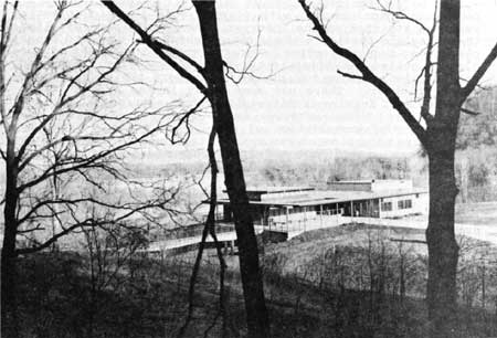
| Figure 18: The visitor center as viewed from the Fire Point trail, ca. 1960. Photographer unknown. Negative #691, Effigy Mounds National Monument. |
The Green Thumb Nursery of Cedar Rapids, Iowa, won the contract for landscaping the headquarters area. This project, too, was delayed by the contractor's inability to haul topsoil to the worksite because of the embargo on Highway 13. When the embargo was lifted, the contractor brought in the topsoil and sodded the area with eighty percent bluegrass sod. The contractor also cleared some trees to create a vista to the Mississippi River from the visitor center. [51] The visitor center was opened to the public on September 17, 1960, and was formally dedicated on May 20, 1961. [52]
Because the entrance sign installed in 1950 was worn and did not comply with the Department of the Interior's standards, the National Park Service contracted with Gordon Peterson to construct a base for a new entrance sign from materials similar to those used in the visitor center and other structures. Monument maintenance workers routed the wooden portion of the sign, which bore a picture of a bear effigy. The sign was completed on May 19, 1962. [53]
About the same time the Park Service installed the new entrance sign, Sny Magill finally became a part of Effigy Mounds National Monument. There were no Mission 66 projects scheduled for Sny Magill; however, some minor development occurred at Sny Magill shortly before the property was transferred to the National Park Service.
In 1957, the Iowa Conservation Commission requested permission from the U.S. Fish and Wildlife Service to build a small road and boat ramp at Sny Magill, and Superintendent Berrett objected. [54] In June 1958, the Iowa Conservation Commission again requested permission to build a ramp, an access road, and parking space for about twenty cars with boat trailers. Late that month, Superintendent Berrett, National Park Service landscape architects George Baggley and Murray George, Regional Archeologist Paul Beaubien, Lloyd Bailey of the Iowa Conservation Commission, and Fish and Wildlife Service Refuge Manager Donald Gray met onsite to determine a location for the access road, and to study possible effects on the mounds. All involved agreed the best route for the road would utilize the existing railroad underpass extending due east to Johnson's Slough for the road, and that the limited development proposed by the Iowa Conservation Commission would not adversely affect the mounds. The state agreed not to construct any other recreational or concession facilities in the area. [55]
The Fish and Wildlife Service prepared a draft special use permit authorizing the construction late that year, and Superintendent Tobin (who succeeded Berrett in November 1958) transmitted it to the Regional Director for comments. [56] The National Park Service offered no objections to the draft permit, and on March 4, 1959, the Fish and Wildlife Service transmitted to the Iowa Conservation Commission an approved permit authorizing the construction of a 1,900-foot-long, 100-foot—wide gravel road and a concrete ramp at Sny Magill. [57] The National Park Service has continued to renew special use permits to allow the state to operate the ramp. [58]
Also under the auspices of the Mission 66 program, Tobin contracted with A.A. Rhomberg of Dubuque, Iowa, to survey the monument's north, west, and south boundaries in 1958. Rhomberg and his crew marked the boundaries with four—by—four—inch cast concrete posts, and set wooden stakes at inter mediate points to aid in erecting a fence along the boundary lines. Rhomberg discovered the monument's east—west line had been incorrectly marked, apparently reducing the size of the monument by 3.445 acres in favor of neighbor Casper Schaefer. Schaefer disputed Rhomberg's report, and retained an attorney to settle the dispute, but the matter never went to court. On June 18, M.A. Moser Construction Company was hired to erect a barbed—wire fence along the recently surveyed boundaries. The fence, completed in September, included four strands of barbed wire set in rock anchors "to assure a taut cattle[—]proof fence." The fence was also intended to prevent poaching and encroachment of logging activities on neighboring lands. [59]
Superintendent Tobin directed a major overhaul of the north unit trails the following year. Tobin had park laborers relocate three segments of the self-guiding loop trail; extended the graveled trail 0.3 miles from the Great Bear mound to two new scenic overlooks where log barriers were built to protect visitors from falling; added 1.8 miles of wooden trail from the overlooks to Hanging Rock; installed five interpretive panels along the trail; and rehabilitated mounds 55, 56, and 57. [60]
Beautification of the developed area of the national monument resulted from the direct orders of President Lyndon Johnson, who, on May 24, 1965, stated his desire that "all Federal buildings be beautified through appropriate planting." Johnson demanded that improvements be made immediately, and called for a progress report on June l. Fortunately, a landscaping plan for the area had been prepared. Superintendent Stuart H. Maule ordered the plants and had them delivered and planted the same day! [61]
There have been some changes to the workshop, residences, visitor center, and parking area in recent years. In 1983, the National Park Service added a twenty-five by twenty foot flammable storage room to the workshop's west side. Designed by Ambrose Jackson and Associates of Omaha, Nebraska, [62] the construction was accomplished by Tesar Excavation and Building Construction of Garnavillo. Tesar began work on October 24, 1983, and completed the project the following February 29. [63] Frustrated by the need to repaint the residences every four years, the Service contracted with Vaaler's Home Improvement Company of LaCrosse, Wisconsin, to install vinyl siding on the structures. [64]
Changes to the visitor center included reroofing in 1973, accomplished under contract with Carl Fitzgerald Roofing and Construction Company, of Waukon, Iowa, [65] installation of a suspended ceiling and ceiling insulation by Stilwell Construction Company in 1981,[66] and another reroofing plus the installation of a skylight in 1986. This work was done by Interstate Roofing and Waterproofing, Inc., of Onalaska, Wisconsin.[67] In 1983, the National Park Service added a basement beneath the visitor center to accommodate the need for curatorial storage and work space. Ambrose Jackson and Associates provided the design. [68] Stilwell Construction Company of Waukon won the construction contract. [69] In 1987 the National Park Service modified the restrooms, eliminating the exterior access. Handicapped access to the restrooms was also installed in 1987. The work was accomplished by Stilwell Construction Company of Waukon. [70]
Over the years, the National Park Service had frequently discussed its concern for the safety of travelers on Highway 76 (formerly Highway 13) with the Iowa Highway Commission. These travelers could not see the monument entrance until they were only 150 yards away. Several near—misses in 1978 prompted the Service to bring the matter, once again, to the attention of the highway commission. In response to the Service's request the state of Iowa added a twelve—foot wide turn lane and relocated the monument's entrance road in 1980. [71]
The Service also improved the north unit trail system. In 1981, Tesar Excavation and Building Construction Company of Garnavillo installed safety guardrails at Hanging Rock and the Twin Views overlook, and constructed a stone stairway directly below Fire Point. [72] Four years later, the Service contracted with West Side Waukon Lumber to erect guardrails on the switchbacks on the Fire Point trail and along the stone stairway. [73]
In recent years, the Iowa Conservation Commission consulted with the National Park Service concerning the Commission's desires to upgrade of the facilities at Sny Magill. In December 1983, the commission's District II fisheries supervisor, David L. Moeller, requested permission to construct a two—lane concrete boat ramp into Johnson's Slough, to provide a 40- by 125-yard graveled parking area, and to trim branches from low—hanging trees. Moeller stated the intent was to improve the facilities for current users, but the Service feared the suggested improvements would increase visitor use of the area. Ranger Jim David noted there were already up to forty cars parked in the area at one time during peak periods, and the monument staff was unable to patrol the area more than once or twice each week during the summer, and less often during the remaining months. Further, the monument's master plan, prepared before Sny Magill became part of the national monument, did not address the Sny Magill unit. Finally, the Service was concerned over both short- and long-term effects on the archeological resources as well as natural resources in the area, particularly the red—shouldered hawk and other endangered and/or threatened species. After several months of consultation with Regional specialists in planning and cultural and natural resources management, Superintendent Thomas Munson informed Moeller that the Service was "not prepared to upgrade those facilities at this time. . . . " and that "The Sny Magill area is the largest extant mound group in North America and, as such, we want to regard it as an archeological trove with very minimal visitor use." [74] The Iowa Conservation Commission appealed to National Park Service Midwest Regional Director Charles ("Chuck") Odegaard for assistance; on September 14, 1984, Odegaard responded in support of Munson's concerns, and stated that the Service would postpone a decision on any increased development at Sny Magill until the monument's new general management plan, scheduled to be prepared in the mid- to late—1980s, was completed. [75]
The National Park Service did allow one minor change at Sny Magill. In 1987, the National Park Service permitted the Fish and Wildlife Service to construct a small information kiosk adjacent to the boat ramp. The kiosk contains information concerning the Upper Mississippi River Wildlife and Fish Refuge and access to the refuge from Sny Magill. [76]
The developments accomplished under the Mission 66 program and after continue to serve the monument well, with the exception of the continued problem of parking congestion during the fall color season. A team of monument, regional, and Denver Service Center personnel currently are exploring the need for further development to meet the monument's general management needs.
| <<< Previous | <<< Contents >>> | Next >>> |
efmo/adhi/adhi7.htm
Last Updated: 08-Oct-2003