|
Effigy Mounds
Administrative History |

|
Chapter Five:
LAND ACQUISITION (continued)
Early Suggestions for Boundary Changes
While the National Park Service struggled to acquire the property which was to form Effigy Mounds National Monument as envisioned in the Baker, Butterfield, and Hummel report and modified by subsequent Service officials, other changes to the boundary were suggested. Within one month of his arrival, Superintendent Kennedy queried the regional office concerning acquisition of an eight—acre piece of property just northwest of the finger of the north unit which abutted Iowa Highway 13. The owner of the property had died and there was a chance the Park Service could acquire the land. A few months later, H.H. Douglass asked if the federal government was interested in purchasing his eighty—acre tract west of the westernmost boundary of the south unit. The Service chose to reject both offers because the parcels under consideration were outside the monument's authorized boundaries. Changes to the boundaries required congressional action, and the Service was not comfortable asking Congress to change the boundaries so soon after the national monument's establishment. [13]
Toward the end of December 1950, Superintendent Kennedy learned that the Liebhardt estate, abutting the monument on the west and from which large blocks of land for the unit had already been obtained, was to be sold. Correspondence on this matter indicates that Kennedy, working through an attorney friend, had a tentative understanding whereby the estate owners would donate to the Park Service a parcel of land bounded on two sides by the national monument and on the third by Iowa Highway 13. Concerned that the purchaser might develop the land in a manner inconsistent with the monument's goals, and hoping to close the gap in the National Park Service frontage on Highway 13, thus reducing poaching activity and illegal trash dumping, Kennedy suggested that the Park Service acquire the property. The Regional position in matters pertaining to boundary changes of Service areas had not changed, however. Such action would require the support of the Washington office and legislative action; and Regional Director Lawrence Merriam had no plans to seek either at that time. The Regional office advised Kennedy to take no action to acquire the property.
|
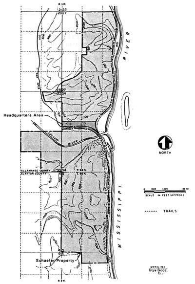
| Figure 10: The original boundary as proclaimed by President Truman included the Yellow River and Jennings-Liebhardt mound groups, the 68-acre headquarters area, and 0.06-acre Schaefer property. |
In 1952 Superintendent Kennedy again recommended the inclusion of the additional Liebhardt land in the monument, having discussed the matter with National Park Service Director Conrad Wirth and Assistant Director Hillory Tolson in the interim. Region II's reaction is summarized in a note initialed by G.F.I. (probably George F. Ingalls) attached to the copy of Kennedy's "Boundary Status Report" recommending this addition:
I told Joe [Kennedy] I thought [Regional Director Howard] Baker might take a dim view of any boundary revision recommendation now to take in the triangular parcel along state highway. This was deliberately not included when monument boundaries were selected. [14]
Founders Pond
Mrs. Addison Parker, Sr., was deeply involved in promoting the authorization of an National Park Service unit in northeastern Iowa, and after 1932 she devoted enormous effort and time toward achieving the national monument's establishment. Louise Parker was a member of the Iowa Conservation Commission during the 1940s while that organization was acquiring the land to be used for the monument, and had remained interested in the unit's development after it was proclaimed. She visited the area in July 1951, at which time, according to park archeologist Wilfred Logan, "We really rolled out what red carpet we had, which wasn't much in those days. . . . We drove her up . . . to see the mounds, see the area, and look over what we were doing, and she was just delighted." [15]
In 1954 Mrs. Parker wrote to Logan to inform him the Des Moines Founders' Garden Club, of which she was a member, would like to do something for Effigy Mounds. Logan and Walter T. ("Pete") Berrett, who succeeded Kennedy as superintendent on June 22, 1953, suggested the club buy a forty-acre plot of land and donate it to the monument. The tract in question was just south of the Yellow River in the south unit and could be purchased from Allamakee County for payment of back taxes and interest, about $200 altogether. One corner of the plot jutted into a backwater lake that was otherwise part of the monument, and that corner was a favorite place for poachers; from the pond they could, with some immunity, shoot the waterfowl on the monument. It was a constant law enforcement problem and source of annoyance. [16]
|
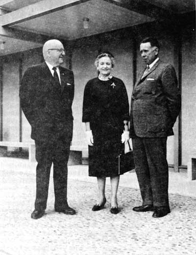
| Figure 11: Louise Parker, longtime friend of Effigy Mounds National Monument, flanked by Associates Director E.T. Scoyen (left) and Regional Director Howard W. Baker, circa 1961. Photographer unknown. Negative #836, Effigy Mounds National Monument. |
Having received a written offer from Mrs. Parker, Superintendent Berrett asked Region II about acquiring this tract of land as a gift from the Des Moines Founders' Garden Club. Berrett informed Regional Director Baker there were two mounds on the property, and that a local farmer also seemed to want it, probably for destructive purposes. Acting Regional Director John S. McLaughlin relayed the request to Washington, commenting:
The suggestion to revise boundaries . . . is not new. Proposals to add these 40 acres to the monument originated in the monument and . . . this office has not looked with enthusiasm on the suggestion. . . . However, Mr. Berrett's advice of August 19 . . . has caused us to revise our thinking. . . .
In view of the existence of two linear mounds on the forty acres in question and the proposal to donate the lands and also with due acknowledgement of Mr. Berrett's administrative problem and the greater ease of fencing since a portion of the boundary would not lie within the pond, we contemplate that our boundary adjustment report for Effigy Mounds will include the recommendation to add this parcel. [17]
By the following January, the Garden Club had purchased the tract and transferred title directly to the National Park Service. Superintendent Berrett notified both Region II and the Washington office. Baker's November 4 memorandum to Director Conrad Wirth recommended revising the monument boundaries to include both the forty—acre Founders' Garden Club tract and an additional 100.83 acres situated one-third mile north of it. This last block of land included a bird and two linear mounds and encompassed the twenty—two—acre tract north of Highway 13. [18] On September 14, 1955, Acting National Park Service Director Hillory Tolson notified Berrett, Mrs. Parker, and the Region II office the U.S. attorney general had approved the purchase. The National Park Service accepted the property subject to congressional approval of a boundary change. The pond into which the corner of the property rejected was renamed "Founders Pond" in honor of the donors, the members of the Des Moines Founders' Garden Club. [19] Mrs. Parker offered to assist the Park Service in later endeavors, if needed.
| <<< Previous | <<< Contents >>> | Next >>> |
efmo/adhi/adhi5a.htm
Last Updated: 08-Oct-2003