|
Effigy Mounds
Administrative History |

|
Chapter Four:
THE AUTHORIZATION OF EFFIGY MOUNDS NATIONAL MONUMENT
Undoubtedly some of the Iowans who worked so hard for the establishment of Effigy Mounds National Monument were frustrated by the delays spanning the three years between the state's acquisition of most of the needed land and President Harry Truman's proclamation of the monument on October 25, 1949. There was no malice involved in the delays. Attempts to adjust to a peacetime economy, problems deciding what land would comprise the national monument, difficulties in acquiring those lands, and differences of opinion concerning the best location for the monument's administrative headquarters all contributed to the postponement of the monument's authorization.
The state of Iowa acquired the land envisioned under the 1938 plan comprising the north and south units of Effigy Mounds National Monument by the end of 1944, but heightened hostilities on the European war front made the proclamation of a park area seem inappropriate at that time. [1] The state agreed to retain the land, possibly leasing some parts of it for grazing, until after the war. The state of Iowa also owned several pieces of property suitable for a headquarters in and near the town of McGregor.
The detached Sny Magill unit, some fifteen miles to the south of the Jennings-Liebhardt group, was also publicly owned. The War Department's Army Corps of Engineers was in the process of transferring Sny Magill to the Department of the Interior for wildlife refuge purposes. According to the terms of the agreement, the Corps would retain the right to overflow the property and to keep clear the waters ponding behind Lock and Dam No. 10, as needed to ensure safe navigation of the Mississippi River. [2]
In late October 1946, the state of Iowa submitted to the secretary of the interior the draft patent conveying to the United States all the land within the modified boundaries of the 1938 plan, with two exceptions. One of these was a small tract at the southwest corner of the Jennings—Liebhardt area which the state was unable to acquire. The other was a two—acre tract in the northwest portion of the Yellow River unit; that segment was occupied by a farmstead, and the state chose not to purchase it. [3] Regional Director Lawrence C. Merriam of the Park Service's Region II agreed that deletion of the two small tracts was acceptable, provided an adequate easement could be obtained to prevent incompatible development adjacent to the Yellow River unit.
During the late 1940s, National Park Service (NPS) personnel also studied the possible inclusion of other tracts of land. One 10.5—acre tract extended part of the northern boundary of the Jennings-Liebhardt unit to the Yellow River. Another block, approximately twenty—seven acres large, was a piece of land the state had been required to take in order to acquire some nearby land needed for the monument; the parcel constituted an isolated holding for the state to which they would lack access, so the state hoped to relieve itself of the property by transferring it to the Department of the Interior as a part of the monument. The largest of the additional tracts, about 146 acres adjoining the Yellow River unit on the north, was one that Dr. Charles Reuben Keyes recommended acquiring, as it contained ten burial mounds. While the NPS did not object to inclusion of these additional lands, all of the proposed additions were outside the boundaries approved in 1938, and they exceeded the size authorized for the national monument by over 200 acres. Thus, acceptance would require legislative action on the federal and state levels.
In 1947, Iowa Governor Robert Blue refused to sign a bill which would have permitted the state to transfer to the National Park Service up to 1,500 acres of land for the national monument, as well as a headquarters site in McGregor. There is no indication that Governor Blue was hostile to the National Park Service, or that he opposed the transfer of land. Apparently Blue objected to the bill's sloppy wording and was concerned about various controversies surrounding the Iowa Conservation Commission and some of its members. [4] For the moment, at least, the state remained limited to the transfer of the 1,000 acres authorized in 1941.
At the same time, a new concept surfaced, suggesting the headquarters be located somewhere other than the town of McGregor. As originally conceived in the Baker, Butterfield and Hummel report, the monument was to be made up of three separate units (the Yellow River unit, the Jennings-Liebhardt unit, and Sny Magill), with the headquarters complex as a fourth unit in or near McGregor. Sometime between 1937 and 1946, the Service tentatively decided to develop the Jennings-Liebhardt area as the principal showpiece of Effigy Mounds National Monument and keep both the Yellow River and the Sny Magill units (if the latter was included in the monument) as reserve research areas.
Assistant Chief Historian Herbert Kahler of the Service's Washington office visited the area in July 1946. Kahler recommended putting monument headquarters somewhere on the Jennings-Liebhardt unit rather than in McGregor. [5] Whether the idea originated with Historian Kahler or Kahler was proposing a concept initiated by others is unclear.
Questions over the inclusion of the detached Sny Magill mound unit also needed resolution. The National Park Service recognized the importance of the Sny Magill mounds. Early in November 1946, NPS Regional Historian Olaf T. Hagen and V.W. Flickinger of the Iowa State Conservation Commission visited the Sny Magill unit, and confirmed previous recommendations concerning the need to preserve the mounds, ". . . particularly because of the location of these mounds on the floodplain, virtually at the water's edge" [6] where they were threatened by shoreline erosion. Further, commercial logging of land adjacent to the area reaffirmed the need to protect the Sny Magill mounds. The National Park Service stopped short of demanding the unit's inclusion in the monument, however, pending discussions to ascertain whether the Army Corps of Engineers would terminate its right to flood the area to maintain Pool No. 10. At the time, the Service thought the Corps' activities were inconsistent with accepted NPS preservation practices.
|
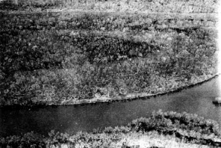
| Figure 9: The Sny Magill mound group and Johnson's Slough as seen from the air, ca. 1983. Negative #2120, Effigy Mounds National Monument. |
Then a cloud formed. While addressing the issue of logging operations so close to the mounds in early December 1946, the NPS discovered the U.S. Fish and Wildlife Service did not own the northern half of the Sny Magill unit as widely thought. Ten years earlier, the Fish and Wildlife Service deeded some lands to the state of Iowa for state park purposes, and the northern half of the Sny Magill unit was among the lands transferred to the state. On December 19, 1946, the confusion deepened when the National Park Service discovered the Corps of Engineers requested the return of seventy—seven acres shortly after Fish and Wildlife Service gave it to the state of Iowa. Citing an act of 1888 which authorized the government to condemn property for river and harbor projects, the Corps of Engineers reacquired the tract on June 4, 1936. [7] Thus, it appeared that the Corps of Engineers, not the state of Iowa nor the Fish and Wildlife Service, owned the northern portion of Sny Magill.
In spite of general agreement the Sny Magill mounds merited protection, by the end of January 1947, conflicts over the Corps of Engineers's potential flooding of Sny Magill and confusion over land ownership raised serious doubts that Sny Magill would be included in the monument at all. Most agreed the best interim protection for these mounds would be provided by a cooperative agreement among the National Park Service, the Corps of Engineers, and the U.S. Fish and Wildlife Service; however, there is no record that the agencies ever formulated such a pact.
There was also disagreement among Corps of Engineers staff concerning disposition of the Sny Magill lands. Col. Aubrey Bond, Deputy Division Engineer, noted that few Corps lands would be suitable for park purposes, and recommended the Corps transfer Sny Magill to the National Park Service. Ten days later, on March 17, 1947, District Engineer W.K. Wilson, Jr., discussed the possibility of the Corps transferring Sny Magill without flowage reservations. On April 22, NPS Regional Historian Olaf T. Hagen and Regional Chief of Lands George F. Ingalls met with Col. Wilson, H.M. Anderly, Floyd 0. Borne, and D.P. Tierney of the Corps of Engineers to discuss the possible transfer. The National Park Service informed the Corps that it had no objections to the Corps of Engineers's reservation of flowage rights, but opposed "clearing, dredging, or deposit of spoil" at Sny Magill. Everyone seemed to agree the transfer would be accomplished as agreed in the April meeting, but one month later, Wilson recommended that the Corps transfer the lands to the state of Iowa, who wanted them for recreational purposes. [8]
Division Engineer C. Kittrell of the Corps' St. Louis, Missouri, district office nixed Wilson's proposal to transfer Sny Magill to the Iowa Conservation Commission. Citing federal legislation, Kittrell reminded Wilson the transfer offer must be made to other federal agencies before they could be offered to a state. If hunting of waterfowl would be permitted on the transferred land, the Fish and Wildlife Service would have the first right of refusal. If the transfer was intended to provide for general recreation, the National Park Service must get the first offer. Wilson expressed his belief that the lands were "regarded as primarily useful for wildlife management," and suggested they be transferred to the Fish and Wildlife Service. [9] Apparently Wilson was the only Corps of Engineers official with this perspective, because shortly thereafter the Corps decided that if the lands were transferred, the National Park Service would receive the first offer.
Further consultations with the Army's District Engineer for the Upper Mississippi River clarified the amount of control the Corps of Engineers would maintain over the Sny Magill tract after its transfer to the Park Service, if such took place, as well as the level of water in the pool behind Lock and Dam No. 10, adjacent to the mound area. By mid-1947, the agencies agreed the water level would be maintained at about nine feet below the mounds and the post—transfer control retained by the Corps of Engineers would be compatible with use of the area as part of the national monument. Still, there were problems associated with the acquisition of Sny Magill. For some time, the War Department had been in the process of transferring some of its Sny Magill land to the Fish and Wildlife Service for use as a wildlife refuge, and both agencies felt it would be better to wait until that transfer was completed before asking for further jurisdiction al changes. Those involved believed that a proposal from a third agency would cause a great deal of confusion and substantially delay the transfer already underway. [10]
By late February 1947 the Park Service and the Iowa Conservation Commission were in general agreement on the boundaries of the area to be donated to the United States. The National Park Service Washington office solicited information from Region II for use in press releases announcing the establishment of the new monument, while the state prepared to condemn for acquisition the last sixty-eight acres of land to be included in the donation. This tract filled in the gap that heretofore had separated the northern Yellow River unit from the southern Jennings-Liebhardt area, and, because it was believed to be the possible site of a prehistoric Indian village, had apparently been recommended for inclusion by Dr. Keyes as early as 1940. The more immediate cause of its acquisition was its request by the Park Service, which hoped to preclude the possibility of undesirable development there, to "round out" the potential monument's boundary, and as a possible site for a headquarters area. As it turned out, this tract became the site of the monument's first headquarters, and subsequently of the existing headquarters facilities. [11]
The state was unable to get the easement it desired from the property owner whose land lay immediately southwest of the Yellow River unit, nor would the owner sell the state the one acre of land they wanted there. The property owner would, as it turned out, give the state a 150-by fifty-foot triangular piece of land in the corner where they wanted to buy the one acre. This was not ideal, but it provided a partial solution to the potential of incompatible development close to the Marching Bear group, and it appeared to be the best deal that could be obtained, so the agreement was consummated. [12]
By 1948 the department of the interior was getting anxious to get the national monument authorized and seek fiscal year 1949 funds for the fledgling area. While the status of the Sny Magill tract remained in doubt, both Region II and Washington-based officials of the National Park Service started to press the department of the interior for the authority to accept such land as the state of Iowa was willing to donate, even if it was not the total acreage that would ultimately comprise the monument. As Acting Regional Director Howard Baker wrote to V.W. Flickinger, Chief of the Iowa Conservation Commission's Division of Lands and Waters:
We have been advised by our Director's Office that the Service is willing to recommend to the Secretary the acceptance from the State of Iowa of the 1,000 acres which it is ready to transfer. The Service is also willing to recommend the submission of a form of proclamation to the President to cover the 1,000 acres, the approximate 204 acres which the State has acquired in excess of the 1,000 acres but does not now have legislative authority to transfer, and the Sny Magill Mounds area. The State lands in excess of 1,000 acres can be accepted by the United States later[,] if and when the State obtains necessary authority to transfer them.
While we assume it will be agreeable to the State if the proclamation is so framed as to include the lands which the State is not yet empowered to transfer, we should appreciate your advising us specifically in this matter.
It would be desirable if this Service were to receive an indication on the part of the Commission that until legislative authority is given to transfer the lands in excess of 1,000 acres such lands might be administered by the National Park Service under a cooperative agreement with the State. [sic] [13]
Flickinger was willing to comply with the National Park Service's requests, but wanted written assurance from the Service that the lands, once transferred, would be used for preservation purposes. Flickinger wrote:
We should like to have from your office a letter of intention to the effect that lands being tendered for the proposed Effigy Mounds National Monument are acceptable and will be recommended to the director's office for presidential proclamation, and establishment of the National Monument when tendered by the state. [14]
Within one week the Park Service gave the requisite assurances to the Iowa Conservation Commission, and drafted a letter to the same effect for the secretary of the interior's signature. The memorandum transmitting the letter for the secretary's signature revealed to some extent what lay behind the "sudden" haste in the negotiations:
Congressman [Benton] Jensen of Iowa, Chairman of the House Sub—committee on Appropriations, is interested in the area and I believe that it should be established as quickly as possible in order that funds for its administration, protection, and maintenance can be obtained for the next fiscal year. Our current appropriation contains an item for administration, protection and maintenance of this area, which we have been unable to use because of unforseen delays in obtaining the land. Now, however, there is complete agreement about the transfer, but I fear that the Congress will eliminate funds included in our 1949 fiscal year estimates for Effigy Mounds unless the lands have been conveyed or are at least in the process of transfer. [15]
In an effort to further expedite the matter, the Park Service decided to omit the Sny Magill unit from inclusion in the initial monument acreage and from mention in the proclamation. There was no question that the unit should eventually be included in the monument, but for the moment it was already under federal control and could, through interim agreements with the other federal agencies involved, be adequately protected, examined, and studied. The question of the previous July concerning the boundary had long since been resolved, [16] but title to the land was still in the limbo of transfer from the War Department to the U.S. Fish and Wildlife Service. Therefore it was believed best to hold the Sny Magill unit in abeyance for the moment, and concentrate on the relatively simple task of getting title to the lands that Iowa wanted to donate. [17]
In replying to a letter from Iowa Conservation Commission Director G.L. Ziemer in March 1948, Region II Director Merriam said the National Park Service was anxious to get the national monument established as quickly as possible and wondered if Ziemer could do anything to speed up the acquisition of lands. The response was immediate, if somewhat tangential. Ziemer wrote a blanket letter to both of Iowa's senators and all eight congressmen. Although Ziemer's letters were intended to be informative, the responses he drew demonstrated considerable confusion on the part of the congressional delegation. For example, one congressman offered to introduce legislation to authorize the national monument, if that would be helpful. The congressman in question was not from the district that encompassed north eastern Iowa, but his reply is a fair indicator of the depth of support the proposed national monument mustered from the Iowa congressional delegation. [18]
By the end of March 1948, all that was needed to complete the establishment of Effigy Mounds National Monument was the handling of a few details. It was probably fortunate that no one guessed it would take one and one—half years to manage the task. Region II personnel made the final formal inspection of the area during the last week in March 1948, to comply with the requirements of the certificate and the possessory report. The Iowa attorney general was in the process of sending to the Conservation Commission the abstracts of title for further forwarding to the National Park Service, and the certificates of condemnation were expected to follow soon after. The state of Iowa transmitted to the National Park Service Patent No. 203 conveying to the United States the 1,000 acres of land covered by attached abstracts and certificates of condemnation. The attorney general's review the patent and its attachments revealed some problems. There was a very small bit of land south of the Yellow River and between the railroad right-of-way and Iowa Highway 13 that had not been included in the patent, and there were other discrepancies between the patent, the plat map, and the boundary descriptions. [19]
In May 1948 other issues emerged that required resolution. There was a long—abandoned county road just south of the Yellow River that had been cleared for use the preceding autumn, thus reaffirming its status as a public thoroughfare. Also, there was a schoolhouse, unused for some years, located on land to be transferred to the National Park Service. Decisions regarding the disposition of both the road and the schoolhouse were needed.
Despite a brief intercession by Congressman Henry 0. Talle of Decorah, Iowa, on behalf of one of his constituents, the issue of the schoolhouse was soon settled, although only on a verbal level. The Conservation Commission ordered the school board to move the building and the school board agreed to do so, but asked for an extension of time beyond the thirty days allotted to effect the move. [20] The board had not removed the schoolhouse as of August 10, 1948, although its removal was expected at any moment.
In the meantime, neighbors began complaining about the uncut weeds, and some farmers sought approval to harvest the hay on proposed monument lands. Because the property was still owned by the state, these matters were directed to the Iowa Conservation Commission. The National Park Service noted it would have no objection to weed cutting or cutting of hay by the state or a private party, provided the vegetation was removed promptly so that there would be no delay when the NPS was ready to take possession.
The Service need not have been concerned about the speed at which the hay would be cut, for on September 1, 1948, the U.S. attorney general's office sent Secretary of the Interior Julius A. Krug a letter with a three-page-long list of errors in Patent No. 203 that required correction before the United States could accept title to the land. The Iowa Conservation Commission received the returned abstracts and supporting papers in mid—September. Three months later the commission requested assistance from the NPS in unraveling the paper nightmare. The Bureau of Land Management recently had accomplished a thorough reorganization, with the result that many of the records the state needed could not be found. In the end, some of the needed records were obtained from the War Department, which had started selling land in the Yellow River unit in 1841. [21]
Clarification of land title issues continued well into the following year. On June 13, 1949, Flickinger returned the patent, abstracts, and the curative data demanded by the U.S. attorney general. Again the Region II office dispatched inspectors to examine the area for preparation of the "Report on Possessory Rights Certificate of Inspection and Possession." The status of the county road had not yet been resolved. Although the NPS requested that Allamakee County condemn the road and vacate possession, the county was unable to comply with the request because a local landowner used the road on occasion. Upon further consideration, Region II Director Howard Baker observed:
The road is just a dirt trail overgrown with grass and weeds. It is impassable when wet. There is no indication of regular or frequent use. We do not believe that the presence of this road will interfere with the contemplated use of the land for national monument purposes. [22]
The Service decided the county road could remain.
The draft proclamation to establish the monument had long since been circulated through the Region II office and the Iowa Conservation Commission, the latter as a courtesy, and forwarded to Washington to await promulgation. The sizeable number of documents pertaining to the land to be donated also went to Washington, where they were again sent to the attorney general for a final opinion. Still four months passed before the president proclaimed the monument's existence. [23]
On August 31, 1949, Acting NPS Director Arthur Demaray accepted title on behalf of the United States, to the 1,000 acres of land conveyed to them by the state of Iowa. In the meantime, the attorney general's office extensively revised the proclamation "in the interest of form and language and to express more clearly the purpose intended," and clarifying that the originally proclaimed monument included only 1,000 acres, with the additional 204.39 acres to be added later. [24]
The Iowa Conservation Commission and State Conservation Officer Milo Peterson assumed protective custody of the new federal lands until the Park Service could get personnel onsite following the presidential proclamation. In anticipation of the proclamation, the 1950 federal budget included $11,136 for the "administration, protection, and maintenance of the monument." [25] The secretary of the interior concurred in the changes made in the authorization. [26] Finally, on October 25, 1949, President Harry S Truman signed the proclamation declaring:
. . . that, subject to all valid existing rights, the lands within the following-described boundaries and shown on the diagram hereto attached and forming a part hereof which belong to the United States are hereby reserved and established as a national monument, to be known as the Effigy Mounds National Monument; and that the lands within such boundaries which do not now belong to the United States shall become a part of such monument upon the acquisition of title thereto by the United States.
Following the proclamation was a page-and-a-half-long boundary description outlining the north and south units of the monument, including the land that the state of Iowa had not yet transferred to the United States. As the proclamation announced:
The State of Iowa . . . has conveyed 1,000 acres . . . to the United States as a donation for national monument purposes, such conveyance having been accepted on behalf of the United States by the Acting Director of the National Park Service on August 31, 1949, and . . . it is contemplated that the State of Iowa will convey the remaining 204.39 acres of such land to the United States for national monument purposes in the near future. [27]
Effigy Mounds National Monument finally existed.
| <<< Previous | <<< Contents >>> | Next >>> |
efmo/adhi/adhi4.htm
Last Updated: 08-Oct-2003