Geological History of Crater Lake
National Park
Proceeding eastward from Llao Rock the rim loses somewhat in height, and at the head of Cleetwood Cove one sees the remarkable spectacle of a lava stream descending the inner slope of the rim. It is the only one that has behaved in this way, and its action throws much light upon the disappearance of Mount Mazama.
The Palisades are less than 600 feet in elevation above the lake, and are composed almost wholly of one great flow. The streams of lava extending northeast from this portion of the rim are broad and much younger in appearance than those forming the great cliffs south of the lake, where the flows are thinner and more numerous.
Roundtop is a dome-shaped hill over the eastern end of the Palisades, and is made up chiefly of the lava stream that formed the Palisades over-lain by two sheets of pumice separated by a layer of dacite. The upper surface of the Palisade flow, where best exposed upon the lakeward slope of Roundtop bears glacial striae, that extend beneath the layers of pumice and dacite of later eruption from Mount Mazama. (See figs. 11 and 19.) It is evident from this relation that Mount Mazama was an active volcano during the glacial period. The occurrence of eruptions from a snowcapped volcano must necessarily produce great floods, and these conditions may account in some measure at least for the detritus-filled valleys of the streams rising on the rim of Crater Lake.
Returning from this glacial digression to the boat trip on the lake, it is observed upon the eastern side of the lake that Redcloud Cliff is rendered beautiful by the pinnacles of reddish tuff near the summit, where it is capped by a great, dark flow of dacite, filling a valley in the older rim and extending far to the northeast. Here the springs begin to gush from the inner slope and cascade their foaming rills to the lake. They recur at Sentinel Rock, Dutton Cliff, and especially under Eagle Crags, as well as farther westward. Their sources in many cases can be seen in the banks of snow above, but in others they gush forth as real springs, whose water must find its way in from the snow upon the outer slope.
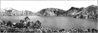
The boldest portion of the rim, excepting perhaps Llao Rock, is Dutton Cliff, which is made more impressive by the deep U-shape notches on either side. The notches mark points where the canyons of Sun and Sand Creeks pass through the rim to the cliff overlooking the lake, as shown in figure 16. These canyons, due to erosion on lines of drainage, belong to the period when the topographic conditions in that region were quite unlike those of to-day. They were carved out by streams of ice and water descending from a point over the lake, and their presence, ending as they do in the air hundreds of feet above the present water level, affords strong evidence in favor of the former reality of Mount Mazama.
FIG. 16—SOUTHERN RIM OF CRATER LAKE AS SEEN FROM WIZARD ISLAND, SHOWING THE NOTCHES ON BOTH SIDES OF DUTTON CLIFF.
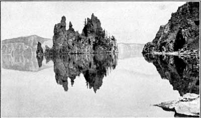
Photograph copyrighted by Kiser Photo Co., Portland, Oreg.The Phantom Ship (fig. 17) is a craggy little islet near the border of the lake under Dutton Cliff. Its rugged hull, with rocks towering like the masts of a ship, suggests the name, and, phantom like, it disappears when viewed in certain lights from the western rim. Standing in line with an arête that descends from an angle of the cliff, it possibly marks a continuation of the sharp spur beneath the waters, or perhaps, but much less likely, it is a block slid down from the cliff. Whatever its history, it attracts everyone by its beauty and winsomeness.
FIG. 17—THE PHANTOM SHIP.
 |
 |