Geological History of Crater Lake
National Park
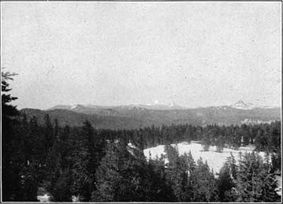
Crater Lake is deeply set in the summit of the Cascade Range, about 65 miles north of the California line. It may be reached, as shown in figure 1, by two routes, one from the Southern Pacific Railroad at Medford or Ashland on the west, and the other from the Southern Pacific at Klamath Falls or Big Spring, just beyond the limit of the map (fig. 1) on the east. Ashland and Medford are in Rogue River Valley, which marks the line between the Klamath Mountains of the Coast Range on the west and the Cascade Range on the east. The journey from Medford by private conance 80 miles to Crater Lake affords a good opportunity to observe some of the most important features of this great pile of lavas. The Cascade Range in southern Oregon is a broad irregular platform, terminating rather abruptly in places upon its borders, especially to the westward, where the underlying Cretaceous and Tertiary sediments come to the surface. It is surmounted by volcanic cones and coulees (fig. 3), which are generally smooth, but sometimes rough and rugged. The cones vary greatly in size and are distributed without regularity. Each has been an active volcano. The fragments blown out by violent eruption have fallen upon the volcanic orifice from which they issued and built up cinder cones. From their bases have spread streams of lava (coulees), raising the general level of the country between the cones. From some vents by many eruptions, both explosive and effusive, large cones, like McLoughlin, Shasta, and Hood, have been built up. Were we to examine their internal structure, exposed in the walls of the canyons carved in their slopes, we should find them composed of overlapping layers of lava and volcanic conglomerate, a structure which is well illustrated in the rim of Crater Lake.
FIG. 3.—CONES AND COULEES OF THE SUMMIT PLATFORM OF THE CASCADE RANGE. UNION PEAK ON THE RIGHT MOUNT MCLAUGHLIN (PITT) IN THE DISTANCE.The journey from Ashland by the Dead Indian road crosses the range where the average altitude is less than 5,000 feet. The road passes within a few miles of Mount McLoughlin and skirts Pelican Bay of Klamath Lake, famous for its fishing. After following northward for some 20 miles along the eastern foot of the range, it ascends the eastern slope, along the castled canyon of Anna Creek to the rim of Crater Lake.
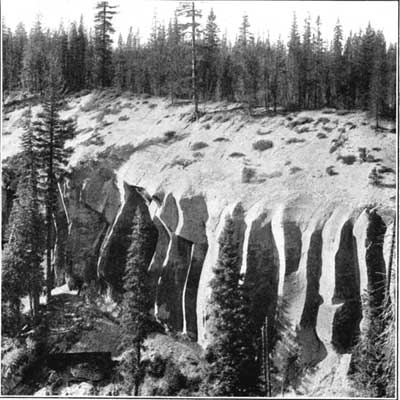
From Medford or Gold Hill the trip is a trifle shorter by the Rogue River road. It affords some fine views of the canyons and rapids of that turbulent stream and of the high falls, where it receives its affluents. Striking features along both roads, within 20 miles of the lake, are the plains developed upon a great mass of detritus filling the valleys. Across these plains Anna Creek and Rogue River have carved deep, narrow canyons with finely sculptured walls (fig. 4), which the roads follow for some distance.
FIG. 4.—JOINTED TUFF OF ANNA CREEK CANYON.With the completion of the railroad on the east the approach to the lake was greatly facilitated. Leaving the railroad near Klamath Falls, a small steamer crosses Upper Klamath Lake and connects with automobile stages to the lake.
 |
 |