.gif)
A Survey of the Recreational Resources of the Colorado River Basin
MENU
Recreational Benefits of Reservoirs
![]() The Grand Canyon
The Grand Canyon
Canyon Lands of Southeastern Utah
Conservation of Recreational Resources
|
A Survey of the Recreational Resources of the Colorado River Basin
|

|
Chapter VII:
THE GRAND CANYON (continued)
SUGGESTIONS FOR DEVELOPMENT OF THE GRAND
CANYON AREA
Probably the best use that can be made of the Grand Canyon area from the standpoint of the American people as a whole is to reserve and develop the entire canyon and bordering plateaus as a place for recreation, primarily of the inspirational type. To those who contend that the present development in Grand Canyon National Park is sufficient to meet this need, it should be pointed out that already increased population and travel make the developed areas in the park so crowded and congested at certain seasons that chances for rest and contemplation are virtually nonexistent. The extension of opportunities to use Grand Canyon, especially the little-known western part, would greatly help in solving the future problem of adequate space for meeting the recreational needs of an increasingly large group.
Plate 5 (in pocket) presents a broad scheme for the general development of the Grand Canyon region, suggesting locations for roads and a limited number of new recreational centers which would be desirable in connection with the recreational use of the proposed Bridge Canyon Reservoir and the western part of Grand Canyon. The development plans for Lake Mead Recreational Area, Hualpai Indian Reservation, Grand Canyon National Monument, Kaibab National Forest, and Grand Canyon National Park should be coordinated on the basis of such an over-all plan to avoid conflicting developments. No one section of this area can be properly planned without due consideration being given to the possible and desirable development of the other sections.
Roads.—At the present time most of Grand Canyon is inaccessible except by arduous pack trips. The only improved roads to the canyon rim are the south and east entrance roads to Grand Canyon National Park and the road from Jacobs Lake to the north rim. On the south side of the canyon, east-west travel is practically limited to United States Highway 66, the heaviest traveled cross-continental highway west of the Mississippi River. On the north, the improved highways make such a big loop to the north that they do not provide for east-west travel through the area. There appears to be need for an improved through road for east-west travel on both the north and south sides of the canyon. At present, administration of the area is hindered by lack of such roads and the public is able to see only the eastern end of the canyon.
Consideration should be given to a road, generally paralleling Lake Mead and the Grand Canyon, that would provide a direct connection between Hoover Dam, Temple Bar, Pierce Ferry, Bridge Canyon Dam, Peach Springs, Frasiers Well, Hualpai Hilltop, and Grand Canyon Village. Such a road would enable persons to travel through the canyon country undisturbed by the nuisances of heavy trucks, fast through traffic, billboards, road side stands, pole lines, and fences. From such a through road, spur roads might be built to outstanding observation points and recreational centers, such as at Temple Bar, Pierce Ferry, Bridge Canyon, Diamond Creek, and Granite Park. These centers could offer overnight accommodations and operate as outfitting and informational centers from which the canyon country could be explored by foot, horseback, or by boat. They could also be sub-centers for the administration of this vast area.
The two existing main roads in the Hualpai Indian Reservation logically would be parts of this proposed road. The road from Peach Springs through the northwest section of the Indian reservation provides access to fine viewpoints. It could be continued down through the Grand Wash Cliffs to the Pierce Ferry Road and thence west around the White Hills to United States Highway 93. The road northeast from United States Highway 66 to Frasiers Well and Hualpai Hilltop connects with a road which continues to Anita and Arizona State Highway 64. The proposed development area above Granite Park, the high point between Prospect and Mohawk Canyons, and Yumtheska Point in Grand Canyon National Monument could be made accessible by spur roads from this section of the proposed through road.
The area north of the river west of Kanab Creek is quite remote and entirely off the beaten paths of tourist travel. Existing roads and trails, for the most part ungraded, are passable only in dry weather. Mount Trumbull, the only settlement in the area, is 49 miles from St. George, Utah, and 81 miles from Fredonia, Ariz., over very poor roads. The boundary of the Lake Mead Recreational Area on the Shivwits Plateau near Mount Dellenbaugh is 82 miles by road from St. George.
There is need for an improved road from Fredonia to Tuweap in Toroweap Valley, thence west over the Pine Mountains, through the settlement of Mount Trumbull, and around Poverty Knoll to the head of Hidden Canyon. From this point there are two possibilities. One would be to carry the road down Hidden Canyon through the Grand Wash Cliffs to Pocum Wash and then south down Grand Wash to Pierce Ferry where there would be a ferry connection with the Pierce Ferry Road south of the river. The other possibility would be to connect this east-west road at the west side of Poverty Knoll, with a north-south road running between Bridge Canyon Dam and St. George, Utah.
The Pierce Ferry-Hidden Canyon route was originally proposed, primarily for recreational travel between the north rim of Grand Canyon, Fredonia, Pierce Ferry, Kingman, and Hoover Dam, at a time when Pierce Ferry appeared to be the only place where it was physically possible to have a crossing of the Colorado River between Navajo Bridge and Hoover Dam. As it has been proposed to have a highway from United States Highway 66 to and across Bridge Canyon Dam, the continuance of that highway north to St. George is within the realm of possibility.
At the present time there are only two existing routes between the populated centers of Utah and Arizona, one by way of Las Vegas, Nev., and Hoover Dam, the other by way of Navajo Bridge. United States Highways 91 and 89 are the two major north-south highways in Utah. Near the Arizona line, United States Highway 91 becomes a southwest-northeast diagonal route to Las Vegas and Los Angeles, and United States Highway 89 swings east many miles to Navajo Bridge and then south to United States Highway 66 near Flagstaff. From United States Highway 66, United States Highway 89 and alternate Arizona State Highway 79 follow indirect courses to Phoenix.
The Arizona State Highway Department has plans for a direct diagonal highway from Phoenix to Kingman and Las Vegas. It will be an extension of United States Highway 93 southeast from Kingman through the Big Sandy Valley to Congress Junction. Should the Bridge Canyon Dam be constructed, it is logical that this road would have a branch to Hackberry on United States Highway 66. This would provide a direct route from Phoenix to the Bridge Canyon Dam.
The primary consideration in the construction of a road north from Bridge Canyon Dam would be the difficulty and expense of constructing a road from the dam to the rim of the Shivwits Plateau. It appears that it might be possible to follow along the bench of the inner gorge from the dam to Separation Canyon thence up the east side of Separation Canyon and Twin Canyon to the rim west of Mount Dellenbaugh. From there to the divide north of Wolf Hole construction would be comparatively simple. Between the divide and the Virgin River there would be a short stretch of heavy construction. The total length of the road from the dam to St. George would be approximately 105 miles.
Should Bridge Canyon Dam be constructed it is recommended that preliminary surveys be made to determine whether such a road connection between United States Highway 66 near Peach Springs, Ariz., and United States Highway 91 near St. George, Utah, is or is not practicable and ultimately desirable.
Development areas.—1. Bridge Canyon section. With the construction of Bridge Canyon Dam and a highway from United States Highway 66 to the dam, the Bridge Canyon area would become one of the major recreational centers of the region. On the basis of traffic counts on United States Highway 66 and the attendance at Hoover Dam and the south rim of the Grand Canyon in Grand Canyon National Park, it is estimated that there may be approximately 365,000 visitors annually to the Bridge Canyon area. These people would desire overlook or observation points from which they could see the dam and the canyon, a lodge and cabins, trailer space and tent camps, parking areas, sanitary facilities, docks and boats for sightseeing trips on the reservoir, a landing field for both private and commercial planes, and concession and information buildings. The spectacular canyon scenery, plus the attraction of the lake, may hold people here for extended visits. Foot and horse trails through Hindu Canyon to Meriwitica and Spencer Canyons and to Peach Spring Draw as well as to viewpoints along the rims of the canyons would probably be popular. Horses and guide service could be furnished by the Hualpai Indians.
The route selected by the Bureau of Reclamation for the highway from United States Highway 66 to the dam starts about 3.5 miles west of Peach Springs, Ariz., and runs generally north to Hindu Canyon. From the north side of Hindu Canyon a 4,000-foot tunnel would carry the road down through the divide between Hindu and Bridge Canyons. From the lower end of the tunnel the route continues down the west side of Bridge Canyon to the narrow bench above the inner gorge of the river and then winds along the bench to the dam site which is about 2.25 miles downstream from the mouth of Bridge Canyon. There would be a road across the dam to a parking area on the north side of the river.
This road down into Grand Canyon would be one of the dramatic features of the area. Turn-out parking areas should be provided wherever possible so that people may stop and enjoy the views. The turn-outs also would be useful for the heavy traffic of the construction period.
From near the upper end of the tunnel in Hindu Canyon a branch road would run west and north to the rim of the Grand Canyon directly above the dam where there is a quarry site for the crushed aggregate to be used in the construction of the dam. The construction camp site is located along this road on the high land between Bridge Canyon and Spencer Canyon.
Because of the difficulties of constructing roads to the rim of the Grand Canyon and of getting water to the rim, it is recommended that the lodge, cabins, and other recreational facilities be located on the rim southeast of the quarry site. In that location the road to the quarry and the water system serving the construction camp could also serve the recreational area. The recreational facilities should be constructed during the early stages of the project, so that they could be used both during and after the construction of the dam.
At a suitable point above the dam, provision should be made for a boat dock from which concessioners could operate sightseeing boat trips on the reservoir. Such trips would be popular because of the unusually spectacular canyon scenery.
2. Peach Springs Draw-Diamond Creek Area. At the present time Peach Springs Draw is the only place where it is possible to drive an automobile to the bottom of Grand Canyon. It would be a comparatively simple matter to construct a road down this draw from United States Highway 66 to the shore of the Bridge Canyon Reservoir where limited development of boat landings, parking areas, and other facilities for the recreational use of the reservoir could be provided. If this road were built, the Peach Spring-Diamond Creek arm of the reservoir would be the major center for boating activities on the reservoir. The precipitous banks of the reservoir in the vicinity of the dam would limit boating operations in that location. It would be possible to continue the road along the shore of the reservoir to a bench in the canyon overlooking Diamond Creek and the Colorado River. This would be an interesting location for a lodge in connection with the harbor development. Peach Spring Draw is dry except after a heavy rain in the immediate vicinity, but Diamond Creek has a continuous flow which could be used as a source of water for the development in this section.
3. Granite Park. This remote section of the Lake Mead Recreational Area and the Hualpai Indian Reservation, now practically unknown, offers canyon scenery of outstanding interest. At the present time there is an unimproved road from Frasiers Well north into Prospect Valley. The road ends about 16 miles north of Frasiers Well at a point about 17 miles south of the mouth of Prospect Canyon. The Aubrey Cliffs wall the east side of Prospect Valley while on the west side the land, thickly covered with large old piñons and junipers, slopes up to the rim of the Grand Canyon. This high rim, around 5,600 feet above the river, provides splendid views in all directions. The scene is entirely different from that of the Bright Angel section of the canyon but is considered to be equally grand. Halfway down to the river is the wide red Esplanade which could be made accessible by road and might be a suitable location for a lodge. From a well-chosen point on the Esplanade, the river gorge, the reservoir, and the towering cliffs of the outer rim would be visible so that the full scale of the canyon could be comprehended. It is difficult to appreciate the size of the canyon from the upper rim or from the bottom.
Granite Park is about 28 miles upstream from the Bridge Canyon Dam site and 17 miles above Diamond Creek. Boat trips on the reservoir and horseback trips along the Esplanade from this development center would be wonderful experiences.
|
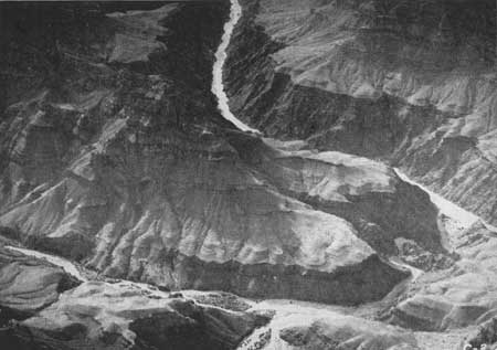
| Figure 75.—Peach Springs Draw (left) joins Diamond Creek near the Colorado River. (Air photo) |
|
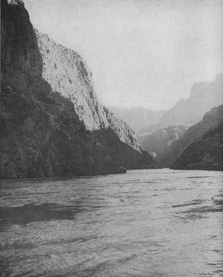
| Figure 76.—The Colorado River. |
4. Toroweap-Whitmore Wash area. The Toroweap-Whitmore Wash area should attract more visitors than any other section on the north side of the Colorado River west of the Kaibab Plateau because of the variety of spectacular scenic and geologic features and the fact that it can be made accessible both by road and by air.
It has been suggested that a loop road, connecting with the main east-west road previously suggested, extend down Toroweap Valley around the south end of the Pine Mountains into Whitmore Wash to the little settlement of Mount Trumbull. From near Mount Trumbull a spur road following an existing automobile trail could be built to the end of Whitmore Point, overlooking Whitmore Canyon, Parashont Canyon, and the inner gorge of the Colorado River.
Due to the scarcity of water in this country, the best location for a lodge would appear to be at the upper end of Whitmore Wash near Big Spring Wash. To the north, up Big Spring Wash, green forest-covered hills rise to Mount Logan. On the east Mount Emma and other volcanic cones form the skyline more than 3,000 feet above the valley. Great, black lava flows descend from the peaks down to the center of the valley around and over sheer cliffs of Coconino sandstone and Kaibab limestone. Farther down the wash, or canyon, are the cinder cones and other formations previously mentioned. In the canyon to the west are numerous evidences of early Pueblo Indian occupation. Most important, however, is the fact that a good flow of water is available at this point. Years ago it was piped here from Big Spring, located high on the slope of Mount Logan.
From the road in Whitmore Wash a spur road could be built on the Esplanade around the end of Whitmore Point to observation points on the inner rim of Parashont Canyon and the rim of the inner gorge of the Colorado River. Trails from the lodge and various points along the roads might lead to the many points of interest such as the Pine Mountains, the lava flows, and the canyons along the reservoir.
It is possible that a suitable handing place for boats can be found either in Whitmore Wash or Twin Canyon which joins Whitmore Wash about a half mile from the Colorado River. If Twin Canyon could be made easily accessible from the reservoir, it would be a delightful place for a camp. The bottom of the canyon presents the appearance of a peaceful, grassy meadow and there is water nearby.
Development on the north side of the Grand Canyon should, it is believed, include the improvement of a spur road from Fredonia-Tuweap Road to the vicinity of Boysag Point.
5. Shivwits Plateau area. The use and development of this area will depend to a large extent upon whether a road is built from Bridge Canyon Dam to St. George, Utah. The chief attractions of the area are the fine views of the Grand Canyon from such points as Price Butte, Sanup Point, Twin Point, and Horse Point. On an average of 5 miles from the Colorado River the plateau ends abruptly with almost sheer walls 1,000 to 1,300 feet high. Below the cliffs is a wide bench, the Esplanade, sloping down to the inner gorge of the Colorado which varies from 2,000 to 3,000 feet in depth. Sanup Point, the extreme south end of the plateau, rises about 4,800 feet above the river to an elevation of 6,000 feet. Deep side canyons cut back into the plateau, and four prominent knobs—Blue Mountain, Price Butte, Mount Dellenbaugh, and Poverty Knoll—rise above the general level of it.
A road northward from Bridge Canyon Dam might reach the rim of the plateau at the head of Twin Canyon, southwest of Mount Dellenbaugh. A short distance from the rim a cross road could head east and south to Price Butte and west and south to Twin Point and Horse Point. Recreational headquarters for the Shivwits Plateau area might logically be located near the crossroads on the rim of Twin Canyon. There is a nice growth of ponderosa pine in this section and water is available.
If a road from Bridge Canyon Dam to St. George is not built, no development for recreational use of the Shivwits Plateau area is recommended. The present trails will suffice for those who wish to explore this remote area.
NEXT >>>
 Top
Top
Last Modified: Mon, Sep 6 2004 10:00:00 pm PDT
http://www.cr.nps.gov/history/online_books/colorado/chap7b.htm
![]()