.gif)
A Survey of the Recreational Resources of the Colorado River Basin
MENU
Recreational Benefits of Reservoirs
![]() Potential Reservoirs
Potential Reservoirs
Canyon Lands of Southeastern Utah
Conservation of Recreational Resources
|
A Survey of the Recreational Resources of the Colorado River Basin
|

|
Chapter VI:
POTENTIAL RESERVOIRS (continued)
LITTLE COLORADO DIVISION
Of the five potential reservoirs in this division, the Forks site located near Holbrook, Ariz., and Petrified Forest National Monument offers the best possibilities for recreational development and use. Preliminary plans call for a reservoir having ban average water surface of 4,300 acres with a maximum fluctuation in water level of only 10 feet. The reservoir area should include a protective strip of land around the entire lake and a suitable area for public recreational use.
Though the other reservoir projects are not likely to be of recreational importance, they are located in a region rich in archeological remains. Archeological surveys should be made of the reservoir areas well in advance of construction operations.
VIRGIN DIVISION
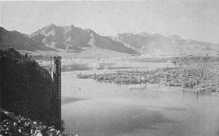
The Virgin City Reservoir site on the Virgin River near Zion National Park is suitable for the development of an important water recreation area that will supplement the scenic attractions of the park. Many of the visitors to Zion National Park and the people living in the valley would use the reservoir for picnicking, camping, swimming, fishing and boating. The proposed Lower Gunlock Reservoir on the Santa Clara River in Utah and the Delmue Reservoir near Pioche and Caliente, Nev., should be attractive to the people living in the vicinity.
|
| Figure 64.—Virginia City Dam site—most of the land in the middle distance would be flooded. Towers of Zion National Park in background. |
BOULDER DIVISION
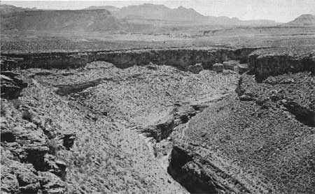
The two major proposals in this division, Marble Gorge and Bridge Canyon Dams, are discussed in Chapter VII. The site for the proposed Coconino Dam is in the canyon of the Little Colorado River 8 miles below Cameron, Ariz. Cameron, an Indian trading post and tourist court, is on United States Highway 89, near the junction of that highway and the east entrance to Grand Canyon National Park. The proposed dam, rising 260 feet above bedrock, would create a reservoir having a maximum surface area of 36,000 acres and a minimum surface area of 1,000 acres, with a 40-foot difference in water levels between the two.
Considering that there will be a wide variation in water surface area, that the primary purposes of the reservoir are silt and flood control, and that there is not likely to be good fishing, the reservoir will have little recreational use.
The other two potential reservoirs in this division are the Alamo on the Bill Williams River and the Sentinel on the Gila River. Both reservoirs are proposed for flood and silt control. Due to the sparse population of the region and the uncertain flow of the rivers, these reservoirs probably will have little or no recreational value.
GILA DIVISION
All of the proposed reservoirs in the Gila Division will have some recreational use because of the absence of natural lakes in this important recreational region. Each reservoir should be planned and developed to provide for as much recreational use as is possible consistent with the primary use of the water. The McDowell and Horseshoe sites are suitable for the development of important recreational areas serving the Phoenix metropolitan district. The Buttes Reservoir would serve the Florence area; Box Canyon, the Wickenburg area; and Charleston, the Tucson-Bisbee area.
|
| Figure 65.—Horseshoe Reservoir site in Verde Valley, Ariz. |
NEXT >>>
 Top
Top
Last Modified: Mon, Sep 6 2004 10:00:00 pm PDT
http://www.cr.nps.gov/history/online_books/colorado/chap6c.htm
![]()