


Survey of
Historic Sites and Buildings
 |
SARATOGA NATIONAL HISTORICAL PARK New York |
 Saratoga |
| ||
Advancing down the Hudson River as part of a grand design for conquering the Northern States, the British Army of Gen. John Burgoyne clashed in September 1777 with the American Army of Gen. Horatio Gates. The Battle of Saratoga and the resulting surrender of Burgoyne's army wrecked the British campaign. Saratoga was the turning point of the war in the North. Vastly more important, it was the turning point of the Revolution. Not only did the colonists draw new hope at a critical moment when defeat would have been disastrous, but the victory also had a decisive influence on negotiations in Europe for an alliance with France. Without French aid, the American cause would almost certainly have failed.
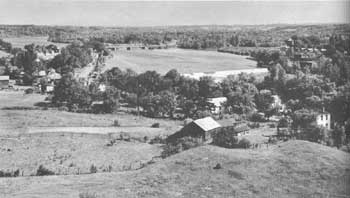 |
| A view looking northeastward over the Hudson River, from Stark's Knob at Schuylerville (Old Saratoga). Gen. John Stark occupied these heights on October 12, thus closing the final gap in the American lines and trapping Burgoyne's army. (National Park Service) |
Saratoga National Historical Park preserves 1,429 acres of the rolling countryside along the Hudson where the two armies battled. Paved roads give access to the sites of significant phases of the action, to the opposing redoubts and fortifications, and to the headquarters of Burgoyne and Gates, all of which are identified and interpreted. A 25-acre detached section of the park at nearby Schuylerville includes the restored and refurnished Schuyler Mansion, summer residence of Gen. Philip Schuyler, who relinquished command of the American force to General Gates almost on the eve of the Battle of Saratoga.
The ceremony of surrender by the British took place at the Field of Grounded Arms, not part of the park, as Schuylerville. (See p. 211.)
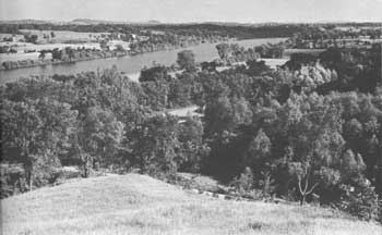 |
| A view looking southeastward from the British River Redoubts at Saratoga. This shows the heart of the final British position, the Great Ravine in the foreground and the plains beyond. (National Park Service) |
 |
 |
http://www.cr.nps.gov/history/online_books/colonials-patriots/sitea10.htm
Last Updated: 09-Jan-2005