|
The Forest Service and The Civilian Conservation Corps: 1933-42
|
|
Appendix B:
Nomination Forms for National Register of Historic Places—Snake River Ranger Station
|
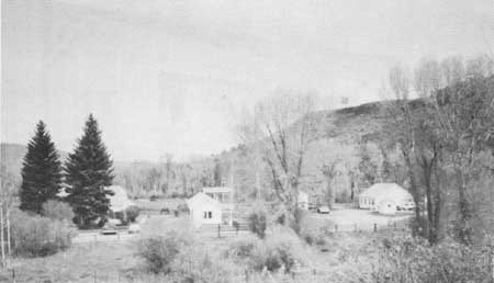
| Figure 129—General view of Snake River Administrative Site from the vicinity of U.S. Highway 26. |
|
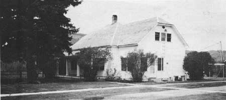
| Figure 130—Snake River Administrative Site Dwelling (Building 1), looking west. |
|
| Figure 131—Snake River Administrative Site Bunkhouse (Building 2), with Fire Cache (Building 3) to the rear. |
|
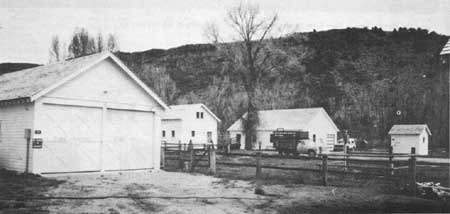
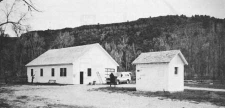
| Figure 132—From left to right: Snake River Administrative Site Fire Cache (Building 3), Barn (Building 5), Warehouse (Building 6), and Gas House (Building 8). |
|
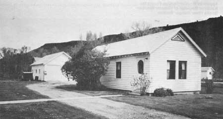
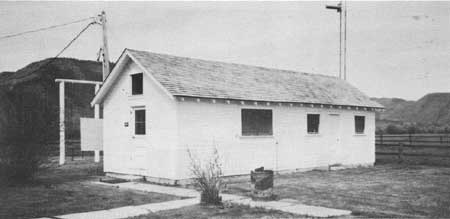
| Figure 133—Snake River Administrative Site Office (Building 4). The original woodshed forms the left half of the existing structure. |
|
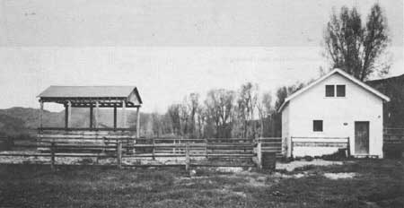
| Figure 134—Snake River Administrative Site Hay Shelter (Building 9) and Barn (Building 5). |
|
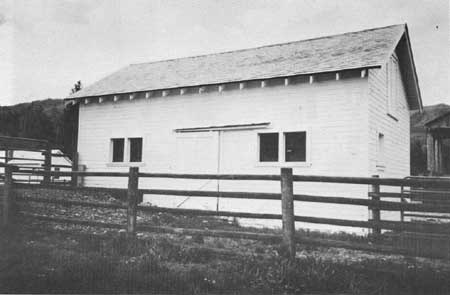
| Figure 135—Snake River Administrative Site Barn (Building 5). |
|
| Figure 136—Snake River Administrative Site Warehouse (Building 6, at left) and Gas House (Building 8). |
|
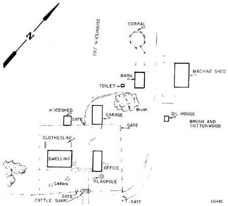
| Figure 137—The 1934 Improvement Plan map of the Snake River Administrative Site. |
|
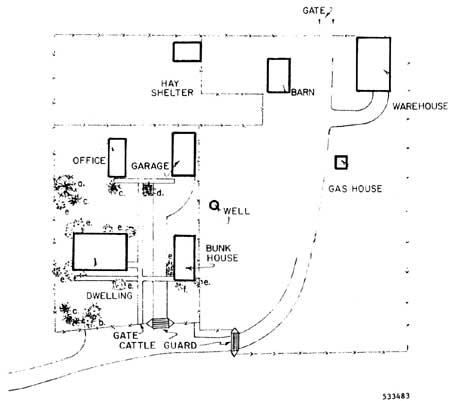
| Figure 138—Map of Snake River Administrative Site when the nomination was drawn up. |
Excerpts from
UNITED STATES DEPARTMENT OF THE INTERIOR
NATIONAL PARK SERVICE
NATIONAL REGISTER OF HISTORIC PLACES
INVENTORY — NOMINATION FORM
FOR FEDERAL PROPERTIES
Name:
Snake River Ranger Station
Snake River Administrative Site
Location:
U.S. Highway 26
Swan Valley, Idaho
Classification:
Category: District
Ownership: Public
Status: Occupied
Accessible: Yes, restricted
Present Use: Government
Agency:
USDA Forest Service, Intermountain Region
324 25th St
Ogden, Utah
Location of Legal Description:
Targhee National Forest Supervisor's Office
420 North Bridge Street
St. Anthony, Idaho
Representation in Existing Surveys:
Targhee National Forest Cultural Resource Inventory
September 13, 1982 (Federal)
Targhee National Forest Supervisor's Office (Listed as TG-464)
St. Anthony, Idaho
Description: Condition: Good, Altered, Original Site
DESCRIBE THE PRESENT AND ORIGINAL (IF KNOWN) PHYSICAL APPEARANCE
The Snake River Ranger Station consists of eight buildings situated on 132 acres of land on the south bank of the South Fork of the Snake River. Now used by the Targhee National Forest's Palisades Ranger District as a base for work crews, the Station was originally the headquarters for the Caribou National Forest's Snake River Ranger District.
The grounds: The Ranger Station site was withdrawn from the public domain by Presidential Proclamation in 1908. The withdrawal included the SE1/4 and that part of the S1/2 of the NE1/4 lying south of the Snake River in Sec. 32, T.2N., R.43E., Boise Meridian. In 1928, the W1/2 of the SE1/4 of Sec. 32 was released and lots 4 and 5 and the SW1/4 of the SW1/4 of Sec. 33, T. 2N., R.43E., were added. This action exchanged unwatered for watered pasture. At the present time, the Forest Service utilizes only that portion of the Ranger Station site that lies north of U.S. Highway 26. This is the area included in the proposed National Register District. The balance of the site is being considered for release into the public domain, as part of Targhee and Caribou National Forest land management planning. It is now being used by ranchers to hold cattle before they are placed on local allotments,
The area around the Ranger Station has been leveled. The ground around the dwelling, bunkhouse, office and fire cache have been seeded with grass. Two spruce trees have been planted in front of the dwelling, and lilacs have been planted around the grounds. The un-landscaped portion of the Station site is used as pasture, and is covered with meadow fescue, clover and weeds. Cottonwoods, Russian Olive and willows grow along the banks of the Snake River and in the pasture.
The riparian and meadow vegetation retain the appearance of the time the proposed District achieved significance. The ornamental vegetation around the building has changed. A narrative for an Improvement Plan (a map of the facilities) prepared in 1936 describes attempts to plant ash, elm, box elder, maple and other trees and shrubs. These attempts ultimately failed because of a lack of irrigation water and winter kills. During the 1930's and 1940's, there were practically no ornamentals on the grounds.
Dwelling (Maps 2 and 3, Building No. 1): The dwelling is a rectangular two-story wood structure with a hip roof. Its original construction date is unknown. The above-mentioned Improvement Plan narrative states that the Station site had been the year-long headquarters for the Snake River Ranger District since 1908, and the dwelling may have been constructed at that time. Informants say that the dwelling was standing at the time of the Gros Ventre Flood in 1927. The Improvement Plan narrative says that the dwelling was "completely revised" and "reconstructed throughout" in 1933. Reconstruction substantially altered the appearance of the dwelling. Forest Service records describe the building as "frame." However, walls in the building are relatively thick, and reconstruction may have covered a log structure.
As it now stands, the building has unpainted wood shingles, white shiplap wood siding and white trim. The shingles and trim were painted green from the 1930's to the 1970's. There is a centered porch supported by four square pillars on the east side of the house. There is an enclosed porch and cooler on the north side of the house, and an exposed stone chimney on the west side. In addition to the enclosed porch and cooler, the dwelling includes a kitchen, living room, bathroom, three bedrooms, and four closets. The interior walls are lath and plaster, and the floors are wood. These features are the result of the 1933 reconstruction. Plan R4-1C was used in the reconstruction. Elevations and floor plans for this plan are not available, but a list of materials used in construction is available.
Bunkhouse: The bunkhouse is a rectangular one-story building with a gable roof. The structure is wood-frame. Siding is white wood, clapboard type. The roof consists of unpainted wood shingles, and the trim is white. It includes a kitchen/dining room, living room, bedroom and bathroom. The interior is panelled and the floors are carpeted.
The building was originally constructed in 1933 to the specifications of Plan R4-51 and served as the Snake River Ranger District Office. Deviations from the plan included a bathroom on an enclosed 6 x 8 foot area of the back porch, and built-in cabinets in the office and bedroom. There was no kitchen/dining room. Siding was shiplap type. Roof and trim were green. Interior walls were lath and plaster, and the floor wood. In 1958 the building was remodeled. The office was moved elsewhere, the remainder of the back porch enclosed and the kitchen/dining room added. Following the remodeling, the building served as a bunkhouse. In 1978 a new shower, linoleum, and the carpeting and panelling were installed. The new siding may also have been installed at that time. Elevations and floor plans for the original (1933) plan are available.
Fire Cache (Maps 2 and 3, Building No. 3): The fire cache is a rectangular one-story building with a gable roof. The structure is wood-frame. Siding is white wood, shiplap type. The roof consists of unpainted wood shingles. Trim is white. The building includes a large and a small storage room. The floor is concrete.
This building was originally constructed as a two-car garage, in 1933, according to the specifications of Plan R4-21. Departures from the standard plan, according to the Improvement Plan narrative, consisted of leaving out the side entrance to the garage room and replacing it with a window. The roof and trim were originally green. The exterior of the building has remained unchanged, except for the repainting and reshingling, since 1933. However, the foundation on the north side of the building is settling and will require repair soon. The interior storage rooms have had new shelving installed, but are substantially unchanged. Floor plans and elevations for Plan R4-21 are available.
Office/Storage Building (Maps 2 and 3, Building No. 4): This is a rectangular one-story building with a gable roof. The structure is wood-frame. Siding is white wood, shiplap type. The roof consists of unpainted wood shingles. Trim is white. The rooms include an office and a pump room.
The building was originally constructed in 1932 as a woodshed, using Plan R4-66. Departures from the standard plan consisted of a hand-made door at the back through which to pass wood. The building was then a one-room, 14 x 18 foot structure with green roof and trim. According to the Forest Service Form 7300-2 for this building, an addition was made to the front (east side) of the building in 1957 that more than doubled its size. The Ranger Station Office was then moved into this addition. This information is probably incorrect. The front of the building more closely resembles the woodshed in design, and is located correctly with respect to the existing sidewalks, which are the original sidewalks. The addition was probably made to the back (west side) of the woodshed, and consisted of the pump room. The woodshed was remodeled into an office. The addition is marked by a section of vertical molding on the north and south walls that covers the joins in the siding. A copy of Plan R4-66 is available.
Barn (Maps 2 and 3, Building No. 5): The barn is a rectangular one-and-a-half story wood-frame building with a gable roof. Siding is wood, shiplap type, and painted white. Trim is also white. The roof consists of unpainted wood shingles. A tack room occupies 1/3 of the floor and a lumber storage area occupies the remainder.
The barn was constructed in 1933 according to the specifications of Plan R4-11. Departures from the standard plan included the use of shiplap siding to harmonize with the other buildings, omission of the rear door and installation of a half-sized window, and a large grain bin installed in the mow with an opening in the bottom leading to a small bin in the rodent-proof room. The barn was originally a four-horse barn. Roof and trim were originally green. The exterior of the building has remained essentially unchanged since 1933. By 1981 the rodent-proof room was in use as a tack room. In that year the tack room was enlarged. There is now a door at the rear, and the side door has been removed and the area covered with siding. A copy of the original plan is available.
Warehouse (Maps 2 and 3, Building No. 6): This is a rectangular one-and-a-half story wood-frame structure with a gable roof. Siding is white-painted wood shiplap. Trim is also painted white. The building is roofed with unpainted wood shingles. There are three rooms: an upstairs storage area, another storage area downstairs, an a first-floor shop. Ceilings and walls are insulated and finished with painted plywood.
The warehouse was constructed in 1933 or 1934 in accordance with a plan listed as "Fig. 537" in the Improvement Plan narrative. This was not a standard plan, and no copy is available. Originally the building had an open workroom in one corner, plus a storage area above the workroom. The rest of the interior was not subdivided. Now the upstairs storage is equal in area to the entire first floor, and the workroom has been enclosed to form a shop occupying approximately one-third of the first floor. The original interior walls were open studs, except in the workroom. Insulation and plywood were installed in 1978, and the original sliding door replaced with an overhead door. The date(s) of the other modifications are not known. The exterior of the building largely retains its 1930's appearance, although original roof and trim colors are not known.
Latrine (Maps 2 and 3, Building No. 7): This is a double-unit wood-frame latrine with shiplap siding and a gable roof of wood shingles. The roof is painted green and the sides of the latrine are painted white.
The latrine was built to specifications similar to Plan R4-70 (a "one-holer"). The Improvement Plan narrative states that it was being used by "outside help." It was still in use in 1963 but by 1978 it had been removed from its original location between the garage and barn, and placed in the pasture to the west of the warehouse. It is still there, original in construction detail and finish, but in considerable disrepair. A copy of Plan R4-70 is available.
Gas House (Maps 2 and 3, Building No. 8): The gas house is a one-story rectangular wood-frame building with a gable roof of unpainted wood shingles. Siding is white wood, shiplap type. There is a single door on the south side of the building, with a plywood panel to one side of it. The building has one room.
The Improvement Plan map, drawn in 1934, shows a structure described as an "oil house" in the location of the gas house, and they are likely to be the same building. The Form 7300-2 for the gas house states that it was completed in 1934. However, the 1936 Improvement Plan narrative does not list this building, and the reason for the discrepancy is unknown. Originally the door on the south side was a double door, with the plywood panel being installed sometime after 1978. The roof was originally painted green.
Other Structures: The Snake River Ranger Station also includes driveways, walkways and fences as shown on Map 3. Changes from the original plan can be seen by comparing Map 2 with Map 3 (Map 2 is based on the 1934 Improvement Plan map, Map 3 is based on the existing layout). The most significant changes are the realigning and paving of the access roads and replacement of the yard fence. The former took place in the early 1970's and was done to provide safer access to U.S. Highway 26. The latter occurred at some unknown time. The original fence was woven wire supported by lodgepole pine posts and with a pole along the top. The present fence is a pole-and-rail design.
Several other structures appear in earlier maps and documents, but are no longer extant. The 1934 Improvement Plan map shows an icehouse located 700 feet west of the southwest corner of the fire cache (garage). This structure is not described in the 1936 narrative and it is not now visible on the ground. The corral shown on the Improvement Plan map has also been replaced. The 1936 narrative described two powder houses, constructed according to Plan R4-61 (a copy of which is available). However, there is no description of their locations and they are no longer in existence. Also mentioned in the narrative is a garbage pit with cover (Plan R4-103, with an available copy) that is no longer evident. Finally, a photo, probably taken in the 1940's, shows a second barn located to the west of the office/storage building. This barn was evidently constructed after the Improvement Plan narrative was written, and had been removed by 1969, when it no longer shows on a photo of the Station.
Recent Intrusions: Recent intrusions on the Station consist of a 30-foot gray steel radio tower behind the office/storage building, and a hay shelter to the south of the barn. (Map 3, Building No. 9.) The radio tower was construction between the 1940's and 1969 (perhaps during the relocation of the office in 1958) and is not obtrusive because of its relatively low height and color. The hay shelter was constructed in 1978. It is somewhat obtrusive, primarily because its unfinished woodwork contrasts with the paint on the other buildings.
Station History: This site became the year-long headquarters of the Snake River Ranger District in 1908. The Station facilities expanded in the 1930's. Between 1936 and 1958, the Ranger District's winter headquarters were moved to Idaho Falls. Between 1958 and 1961, summer headquarters were also moved to Idaho Falls and the Station became a Work Center; field crews resided at the Center when there was Forest work to be done in the vicinity. It has continued to be used in this capacity to the present. In 1975, administration of a portion of what had been the Snake River Ranger District was transferred from the Caribou National Forest to the Targhee National Forest. The transfer included the Snake River Ranger Station.
Significance:
Period: 1900-
Areas of Significance: Architecture, Politics/Government, Social/Humanitarian
STATEMENT OF SIGNIFICANCE
The significance of the Snake River Ranger Station lies in its ability to represent work done by the Civilian Conservation Corps for the Forest Service, and the characteristic organization of the Forest Service from the 1930's to the 1940's. It is of unusual importance to the Targhee National Forest because it is well preserved and the best-documented example of a C.C.C.-era Ranger Station now administered by the Targhee.
Virtually all of the buildings now present at the Station were constructed with the use of Civilian Conservation Corps labor. The exceptions are the house, which was rebuilt with C.C.C. labor, and the hay shelter. Facilities construction loomed large among the jobs which the Corps performed for the Forest Service. The Corps provided manpower resources commensurate with the Service's management tasks for the first time in the Service's history: new Ranger Stations were built, new roads constructed, and large scale resource protection and management activities were begun. On the Targhee National Forest there were eight Ranger Districts during the C.C.C. era. All were served by facilities constructed largely by the C.C.C. (McDonald, 1983). Although originally part of the Caribou National Forest, the situation was the same on that Forest, and so the Snake River Ranger Station is associated, by virtue of its C.C.C. construction, with this important phase in the Forest Service's development.
Rapid development of Forest Service facilities was aided by the use of standardized plans in their construction. The buildings of the Snake River Ranger Station were constructed in accordance with these plans, and therefore embody "the distinctive characteristics of a type, period or method of construction." Although the buildings have undergone subsequent modifications, exterior details and the scale of the Station remain largely unchanged, and it is in these details that the significance of the Station inheres. In addition, the available documentation, which in most cases includes the original plans, does make it possible to establish their original appearance. In this respect, the Snake River Ranger Station would be better able to represent Forest Service building types of the 1930's than would other facilities, many of which lack the original plans or records of subsequent modifications, making it more difficult to establish their original appearance.
The ability of the Snake River Ranger Station to represent a type of construction goes beyond its ability to represent individual building plans. The Station as a whole represents Forest Service Ranger Stations of the 1930 to 1950 period, and in turn represents the structure of the organization which it served. An important characteristic of the Station is that prior to the conversion of the original office into a bunkhouse, the residential facilities consisted of a single-family dwelling and a one-bedroom office. Until the 1940's, many Ranger Districts were managed solely by a Ranger and assistant (often seasonal), and the Snake River Ranger Station reflects this administrative structure. This form of administration was suited to an organization which was not intensively managing resources. In the 1950's, demands on Forest Service resources began to increase, with exponential increases occurring in the late 1960's and 1970's. As this occurred, more intensive resource management became necessary and the Forest Service organization expanded, with an increasing number of resource specialists being hired. The result was often an increase in the size of the administrative facilities. The Snake River Ranger Station was spared this expansion because, by the time it occurred, administrative headquarters for the District had been moved to Idaho Falls. Consequently, the Station retains its original scale (the bunkhouse is virtually the same size as the original office, and the hay shelter is not out of keeping in size or function with a Ranger Station that also has a barn). Again, significance inheres primarily in the exterior scale and appearance of the Station.
The Snake River Ranger Station is unique on the Targhee in retaining its original scale and coherence of design. Other C.C.C.-associated Ranger Stations either have more in the way of recent intrusions, as a result of organizational expansion, or have been abandoned as unsuited to current needs, frequently with the structures or land having been sold as excess property. As such, it is exceptionally important at the local level, and merits an exception to the consideration that places having achieved significance within the last 50 years are not normally eligible for the National Register.
Major Bibliographic References
McDonald, James A.
1983 Cultural Resources Evaluation, Targhee National Forest Administrative Sites of the
Civilian Conservation Corps Era. Ms., Targhee N.F., St. Anthony, ID.
USDA Forest Service, Intermountain Region, Targhee National Forest,
Palisades Ranger District 7300 (Buildings) File.
Geographical Data:
Acreage of nominated property: 132
UTM References:
A12 466110 4812040 B12 467600 4812020
C12 467580 4810780 D12 466140 4810790
Verbal Boundary Description:
From the signed entrance to the Station grounds along U.S. Highway 26, proceed
east along the highway 3,000 feet (approximately). At this point a fence
runs due east from the highway to the Snake River. The boundary follows
this fence line to the river. At the river, follow the bank downstream
7,340 feet. At this point, a fence runs due south from the river. The
boundary follows this fence to Highway 26. At the highway, turn east and
follow the highway back to the Station entrance.
State: Idaho, Code: 16, County: Bonneville, Code: 019
Form Prepared By:
James A. McDonald, Forest Archaeologist
Targhee National Forest
420 N. Bridge Stree
St. Anthony, Idaho
(208)624-3151
1-7-83
| <<< Previous | <<< Contents>>> | Next >>> |
ccc/appb.htm
Last Updated: 07-Jan-2008