|
WIND CAVE
Guidebook 1940 |

|
| OPEN ALL YEAR |
 |
Wind Cave NATIONAL PARK SOUTH DAKOTA |
||
|
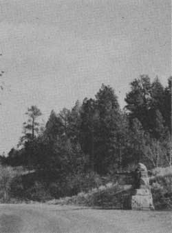
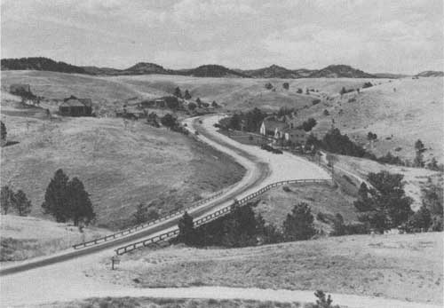
ENTRANCE TO THE PARK FROM THE WEST
| ||||
THE Black Hills Region of South Dakota, in which Wind Cave National Park is located, has a fascinating story of earth making to tell. It ranges in interest from ancient fossil deposits buried in the Badlands, telling a tale of prehistoric alligators, rhinoceroses, three-toed horses, and other long-extinct animals, to the lofty "needle" formations which erosion has sculptured from masses of granite high up the forest-clad slopes of the Black Hills.
Wind Cave lies in the great Pahasapa limestone formation which also contains several other large subterranean caverns. The facts about the discovery of the cave are little known, but it is generally believed that it was discovered by Tom Bingham, a Black Hills pioneer, while hunting deer in 1881. He was attracted by a strange whistling and after searching about in the undergrowth, he discovered that it was caused by wind escaping through a small hole in some rocks. This hole, not more than 10 inches in diameter, is the only natural opening to the cave so far discovered. It is located a few steps behind the present cave entrance.
The strong currents of wind that blow alternately in and out of the mouth of the cave suggested its name. This strange phenomenon is believed to be caused by changes in the atmospheric pressure outside. When the barometer is falling, the wind usually blows outward; when it rises, the wind blows in. Many visitors enjoy stopping at the cave entrance to post themselves on weather indications.
The present cavern opening was made by digging down about 6 feet to a long, winding fissure, or tunnel, leading into corridors and galleries decorated with a variety of crystal formations. These formations differ radically from those found in most caverns because stalactites and stalagmites are practically nonexistent in this cave, a feature that adds to its unique interest. Here the formations are of the unusual boxwork and frostwork type. The boxwork is composed of delicately colored crystals arranged in honeycomb pattern. Tiny white crystals, sometimes superimposed on a pink background, hang in clusters from ceilings and ledges to form a frostwork decoration of rare beauty. The cavern is approximately 10 miles in extent but has not been fully explored.
Wind Cave National Park was created by act of Congress, dated January 9, 1903. Its boundaries were subsequently extended, and it now includes an area of 11,818.94 acres. Like all other national parks it is a wildlife sanctuary. Buffalo, elk, antelope, and deer range the area and are frequently seen from the main highway.
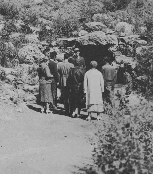
ENTRANCE TO WIND CAVE
COLORFUL HISTORY
In addition to its natural beauty and scientific interest, the southwestern section of South Dakota has a colorful and picturesque history. Possibly a French explorer made his way into it as early as 1683, and the Verendrye brothers are said to have visited it in 1743.
The Sioux Indians, a tribe conspicuous even among Indians for strength and bravery, long occupied the region and only submitted to white settlement after a bitter and tragic struggle. This tribe is believed to have originated east of the Alleghenies, but as early as 1632 the French found them in Wisconsin and Minnesota. Some of their descendants are today living on the Pine Ridge and Rosebud Indian Reservations, a short drive from Wind Cave Park.
According to an Indian legend, the four winds were major deities of the Plains tribes, and wind was associated in their belief with the breath of life and the vital principle. Hence the Cave of the Winds was a sacred spot to them. Many of the Plains tribes had myths in which the story was told of how the buffalo first came out of a cave (this was an objectification of the fact that all flesh is made of earth), and Chief Joseph White Bull (Pte San Hunka), Sitting Bull's living nephew, has been quoted as saying that the Sioux believed that the Wind Cave in the Black Hills was the cave from which Wakan Tanka, the Great Mystery, sent them out into the Sioux hunting grounds. This was one reason why the Sioux fought so hard for the Black Hills when they were invaded by the whites. The Chief also has said that some of his people still hoped that when they had regained favor of their gods the buffalo would once more issue from that cave and fill the plains.1
1"Warpath," by Stanley Vestal.
The war clouds that ended in the conflict of 1861-65 and Indian uprisings under the leadership of Red Cloud, Sitting Bull, Spotted Tail, and other great warriors hampered the development of this region, but in 1874 an expedition through the Black Hills led by Gen. George A. Custer resulted in the discovery of gold on French Creek and settlement followed rapidly. From 1879 to 1886 were boom days that made legendary figures of such pioneer characters as Wild Bill Hickok, Deadwood Dick, Calamity Jane, and Preacher Smith. All four are buried in Deadwood.
Long before the Black Hills were well known for the scenic beauty that resulted in the establishment of Custer State Park in the heart of this rugged region and construction was begun on the Rushmore Memorial, the region was famous throughout the world for its mineral wealth, especially gold. The Homestake Mine at Lead is the largest gold mine in the United States. In 1933 almost one-fourth of the gold production of the United States came from the Black Hills. Since production began in 1875, gold totaling approximately $300,000,000 in value has been mined in this region. Some of the other minerals found in the region of economic value are silver, lead, copper, iron, tin, and tungsten ores; columbite, tantalite, mica, arsenic, lithia, and cesium minerals; fuller's earth, bentonite, volcanic ash, coal, petroleum, and structural materials.
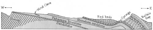 SECTION ACROSS THE EAST SLOPE OF THE BLACK HILLS UPLIFT, THROUGH WIND CAVE LOOKING NORTH |
GEOLOGICAL HISTORY OF WIND CAVE
Caves, in general, may be classified in three divisions, according to the kind of rock in which they have developed. They may be formed in limestone, in igneous rocks, or in sandstone. Of these, limestone caves are the most important and most frequently attain great size. Wind Cave is a limestone cavern.
The limestone layer in which Wind Cave is formed varies in thickness in the Black Hills region from 300 to 630 feet. It is known as the Pahasapa limestone, a local formation of Mississippian age deposited in a great inland sea some 300 million years ago. Following the deposition of this limestone, it was elevated above the sea. Several such periods of elevation and subsidence occurred during geologic history. During these periods of submergence, the Pahasapa limestone was overlain by other sediments several hundred feet in thickness. The final upthrust of the land probably occurred during the latter part of the Cretaceous period, some 60 million years ago. The beginning of the formation of Wind Cave probably dates from that time.
Limestone which has been subjected to several such periods of uplift or warping becomes fractured or broken. These cracks develop in all directions and at all angles. Those close together served as the pattern for the characteristic "boxwork," formed in the following manner: Rain water seeping down from the surface through decaying vegetation absorbed carbon dioxide, which renders the water more soluble for limestone. This carbon dioxide-bearing water takes some of the limestone into solution, then upon evaporation deposits it in the cracks or crevices below. Later the more soluble limestone between the fins of boxwork was dissolved away, leaving the boxwork formation as it is seen today.
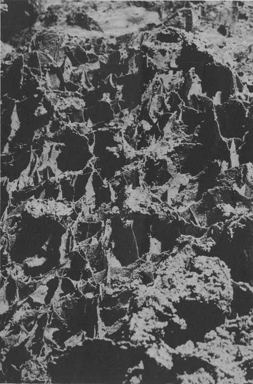
TYPICAL EXAMPLE OF BOXWORK FORMATION
WILDLIFE
Another novel attraction at Wind Cave National Park is a display of wildlife representative of the type of game that roamed the Dakota hills in the early days. Protected here from the hunter, the traveler will find a large herd of bison and small groups of antelope, elk, and deer.
Visitors usually can get close, unobstructed views of the bison herd from the main highway which winds through the rolling hills of the park. The whole park area is surrounded by a fence which keeps the animals from straying over the range. It should be remembered that the game is wild and cannot be treated like domestic animals. It is not wise, therefore, to get out of your car or to go near any of the game animals.
In this park all the wildlife is shown in its natural habitat, giving the onlooker the thrill of seeing wild animals in the open rather than from behind fences or bars.
Small groups of antelope may often be seen by the careful watcher. The elk frequent the open parts of the park during the night, late afternoon, and early morning. During the day they return to the timbered sections. The deer usually remain in the woods, but may sometimes be seen crossing the grasslands.
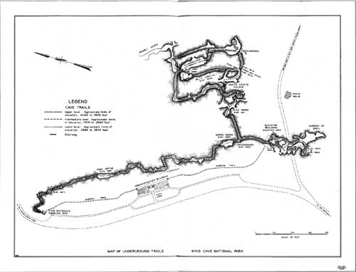
MAP OF UNDERGROUND TRAILS — WIND CAVE NATIONAL PARK
(click on image for a PDF version)
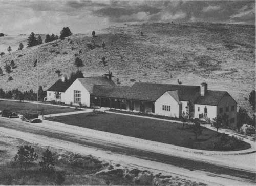
PARK HEADQUARTERS NESTLING AMONG THE ROLLING HILLS
GENERAL INFORMATION
Wind Cave National Park is administered by the National Park Service of the United States Department of the Interior, and the representative of this bureau in charge of the park is Harry J. Liek, superintendent. His address is Hot Springs, S. Dak.
CAVE TRIP.—All trips through the cave are under the guidance of competent park rangers. The entrance fees are as follows:
| Cents | |
| Adults | 75 |
| Children, 12 to 16 years | 25 |
| Children, 5 to 12 years | 15 |
| Children under 5 admitted free. | |
This fee schedule includes the use of the elevator on the outgoing trip.
The trip through the Cave is not unlike the average hike over a mountain trail. Comfortable walking shoes should be worn. The temperature is 47°, and does not vary winter or summer. It is advisable to take a light sweater or jacket. The cave is electrically lighted.
ELEVATOR SERVICE.—During the year 1935 an elevator was installed in the cave for the convenience of the public. This saves one the necessity of climbing out of the cave.
SPECIMEN DISPLAYS.—Specimens of formations from the cave are displayed in the headquarters building for study purposes and general inspection by the public. The handling of formations In the cave or the collection of souvenirs is strictly prohibited.
During the summer a wild-flower display is also maintained. It includes all the common species of Black Hills flora for the locality. Flower picking in the park without permission of the superintendent is strictly forbidden.
ACCOMMODATIONS.—No hotels or tourist cabins are located in the park, but a public campground with free wood and water is maintained near headquarters. Lunchroom facilities and soda-fountain service are provided. Campers' supplies, curios, and miscellaneous articles are obtainable.
Hot Springs is the southern entrance to the Black Hills. It is 10 miles south of Wind Cave National Park on United States Highway No. 85A. It is the post office for the park and has good hotels, camps, and garages. Hot Springs has a national sanatorium and State soldiers' home and is known as the picture town of the Black Hills.
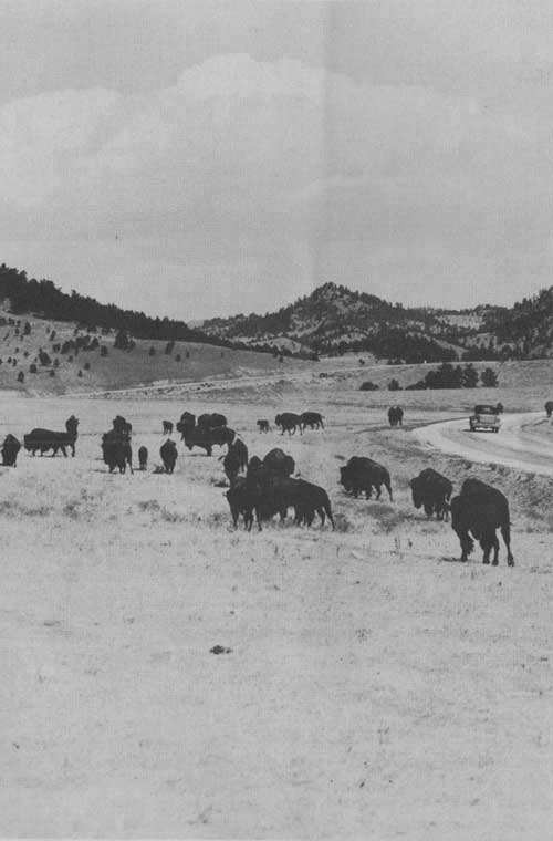
HERDS OF BISON ARE OFTEN SEEN FROM THE HIGHWAY
HOW TO REACH THE PARK
BY AUTOMOBILE.—Wind Cave National Park is on United States High Way No. 85A and can be reached by side trips from either United States Highway No. 16 at Custer or over State Highway No. 87 through the Custer State Park.
BY RAILROAD.—The park is accessible from the following railroad stations: Hot Springs, on the Chicago, Burlington & Quincy and the Chicago & North Western Railroads; Pringle and Custer, on the Chicago, Burlington & Quincy Railroad; and Buffalo Gap, on the Chicago & North Western. Passengers wishing to visit Wind Cave National Park as a side trip from Edgemont or Buffalo Gap (28 and 14 miles, respectively, from Hot Springs) may stop over on excursion tickets. From many eastern points tickets to Yellowstone or Glacier National Parks are good for passage through Edgemont.
BY BUS.—Hot Springs is served by the Black Hills Transportation Co. from Cheyenne, Wyo., on the south by way of Rapid City, S. Dak. Connections are made at Cheyenne with the Burlington Transportation Co. and the Interstate Transit Lines. From the east and north Hot Springs may be reached through Rapid City via the Rapid City Lines, Red Ball Lines, and Palace City Bus Lines from Huron, Mitchell, and Sioux Falls, S. Dak. From Bismarck, N. Dak., Central Bus Line provides service to Pierre, S. Dak., connecting with Rapid City Lines for Rapid City and Hot Springs.
BY AIRPLANE.—High-speed de luxe airplane service from all points to Cheyenne is available through United Air Lines. Wyoming Air Service, operating from Pueblo, Colo., to Billings, Mont., also stops at Cheyenne.
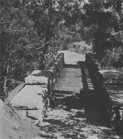
FOOT BRIDGE ON TRAIL LEADING TO CAVE ENTRANCE
NEARBY ATTRACTIONS
Rangers at the park information desk will assist in planning a trip through the Black Hills and also give information about other national parks. In a trip of about 300 miles many interesting areas, including Devils Tower, Jewel Cave, Fossil Cycad, Scotts Bluff, and Badlands National Monuments, Custer State Park, three national forests, both Federal and State fish hatcheries, and a bird refuge may be visited.
JEWEL CAVE NATIONAL MONUMENT, transferred to the National Park Service from the Forest Service by Executive Order of the President on April 1, 1934, is open to the public during June, July and August. It is 14 miles west of Custer on Highway 16. The cave us a series of passages and small rooms, the walls of which are lined with calcite crystals.
FOSSIL CYCAD NATIONAL MONUMENT, created in 1922 to preserve large deposits of fossil remains of fernlike plants that grew many million years ago in the Mesozoic period, is located in the southern edge of the Black Hills, a short distance from Wind Cave. The monument lies several miles from the highway and is not accessible to cars except through private property. As the area is of interest mainly to paleobotanists and geologists, it is not open to the public at the present time. A good specimen of an interesting fossil is on display at Wind Cave National Park headquarters.
BADLANDS NATIONAL MONUMENT.—In sharp contrast to the verdant Black Hills country are the White River Badlands, a barren, treeless region a short distance to the southeast of Wind Cave. Here nature has beautified the earth with all shades of buff, cream, pale green, gold, and rose. Fantastically carved erosion forms rise above the valleys, some of them 150 to 300 feet high. The constantly shifting color and the weird formations make this a region of strong imaginative appeal.
DEVILS TOWER NATIONAL MONUMENT.—Another unusual natural phenomenon of the Black Hills country is the Devils Tower across the State line in Wyoming. This is a great mass of igneous rock towering 600 feet above the Belle Fourche River.
ADMINISTRATION BUILDING Grant photo
GLOSSARY
A brief description of the technical terms used in this booklet and by visitors through the rangers guiding cave:
ARACONITE (4 1)—A mineral which represents one form of calcium carbonate (CaCO3), white or tinted, which frequently occurs as compound or radiating groups of crystals.
BOXWORK (3 1)—The unique honeycomb formation of Wind Cave, composed of calcite with small amounts of hematite.
CALCITE (3 1)—A mineral representing the most common form of calcium carbonate, which effervesces in acid. The formations in limestone caverns are composed principally of calcite.
CHERT (7 1)—A very hard, amorphous form of silica which is frequently found associated with limestone. In Wind Cave the chert is fossil bearing.
CONCRETION—A rounded aggregate of mineral matter formed by precipitation or deposition around some nucleus (not a cave formation).
CONGLOMERATE—A sedimentary rock composed mainly of cemented, rounded gravel.
CRETACEOUS—The last period of the Mesozoic era.
DRIPSTONE (3 1)—Irregularly shaped deposits of calcium carbonate which is precipitated from evaporating water that seeps through the walls of a cave; stalactites and stalagmites are sometimes called dripstone.
ERA—A major division of recorded geological time.
FAULT—A dislocation or movement in rock masses along a plane of fracture,
FLOWSTONE (3 1)—Calcium carbonate (CaCO3) deposits formed by deposition from trickling or flowing water chiefly over walls.
FOSSILS——Remains or traces of ancient animals or plants preserved in sedimentary rock, such as shells or tracks of animals or birds.
FROSTWORK (3 1)—A delicate aggregate of calcite crystals resembling frost; generally pure white.
IGNEOUS ROCKS—Rocks which have been formed by the cooling and hardening of molten rock material.
LIMESTONE (4 1)—A sedimentary rock composed principally of calcium carbonate. It may be produced by the action of algae and invertebrates or by the precipitation of calcium carbonate from water.
METAMORPHIC ROCKS—Igneous or sedimentary rocks altered by heat and pressure. Slate is metamorphosed shale and marble is metamorphosed limestone.
MISSISSIPPIAN—A period of the Paleozoic era.
OUTCROP—An exposure of rock at the surface.
PALEOZOIC—The third great era of recorded geological time. The time of great development of invertebrates, fish, and fernlike trees. The era is subdivided commonly into seven periods: Cambrian (oldest), Ordovician, Silurian, Devonian, Mississippian, Pennsylvanian, and Permian.
SEDIMENTARY ROCKS—Rocks formed by the accumulation of sediment, either in water or on land; may consist of shale, limestone, sandstone, fossils, gypsum, or loess.
STALACTITES—Calcareous cones that hang from the roofs of limestone caves and are formed from the lime-bearing waters that seep through the roof.
STALAGMITES—Structures similar to stalactites which develop on the floor of limestone caves and grow upward by additions from water dripping upon them from the ceiling of the cave. Usually more blunt than stalactites.
TRAVERTINE (3 1)——Calcium carbonate (CaCO3) deposited from solution by springs or running water. Embraces many types of deposition.
Scale of hardness of minerals:
1-Talc
2-Gypsum
3-Calcite
4-Fluorite
5-Apatite
6-Orthoclase
7-Quartz
8-Topaz
9-Corundum
10-Diamond
RULES AND REGULATIONS
THE PARK REGULATIONS are designed for the protection of the natural beauties and scenery as well as for the comfort and convenience of visitors. The following synopsis is for the general guidance of visitors, who are requested to assist the administration by observing the rules. Full regulations may be seen at the office of the superintendent and ranger station.
GUIDE SERVICE.—NO person is permitted to enter the cave unless accompanied by the superintendent or other park employee.
FIRES.—Light carefully, and in designated places. Extinguish completely before leaving camp, even for temporary absence. Do not guess your fire is out—know it.
CAMPS.—Use designated campgrounds. Keep the campgrounds clean. Combustible rubbish shall be burned on camp fires and all other garbage and refuse of all kinds shall be placed in garbage cans or pits provided for the purpose. Dead or fallen wood may be used for firewood.
TRASH.—DO not throw paper, lunch refuse, kodak cartons, chewing-gum paper, or other trash over the rim, or walks, trails, roads, or elsewhere. Carry until you can burn in camp or place in receptacle.
AUTOMOBILES.—Careful driving is required at all times for protection of yourself and other visitors. Your car must be equipped with good brakes, horn, and lights. Passing on curves is prohibited. Obey traffic rules. Tractors with lugs or vehicles without tires are strictly prohibited.
PARK RANGERS.—The rangers are here to help and advise you. When in doubt ask a ranger. Rangers at park headquarters will be glad to help you plan your activity while in Wind Cave and to explain the regulations.
CAMERAS.—Still and motion-picture cameras may be freely used for general scenic purposes.
WIND CAVE IS OPEN TO THE PUBLIC
EVERY DAY THROUGHOUT THE YEAR.
| <<< Previous | <<< Contents>>> |
1940/wica/sec1.htm
Last Updated: 20-Jun-2010