|
OLYMPIC
Guidebook 1940 |

|
| OPEN ALL YEAR |
 |
Olympic NATIONAL PARK WASHINGTON |
||
|
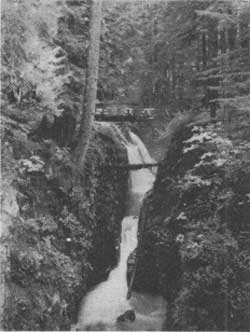
SOL DUC FALLS. Grant Photo
| ||||
OLYMPIC National Park is a spectacular expanse of glacier-clad peaks, flower-strewn alpine meadows, turbulent streams and jewel-like lakes, deep winding canyons and broad valleys supporting a rich forest growth unequaled elsewhere in America. This unspoiled "last frontier," its mountain fastness teeming with vegetation and wildlife, is destined to be preserved as a primeval wilderness, little changed in a thousand years.
Located in the northwest corner of the United States, this park occupies the central interior of the Olympic Peninsula, promontory of the State of Washington, washed on three sides by the waters of the Pacific Ocean, Strait of Juan de Fuca, and Puget Sound. Cool ocean breezes temper the summer weather of the area, and moderate temperatures prevail throughout the year. Little moisture falls in the park in summer, rains being normal for the region except on the western slopes of the Olympic Mountains which have remarkably heavy precipitation in the winter months.
"RAIN FORESTS"
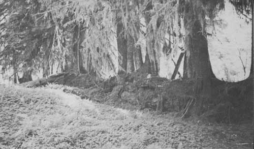
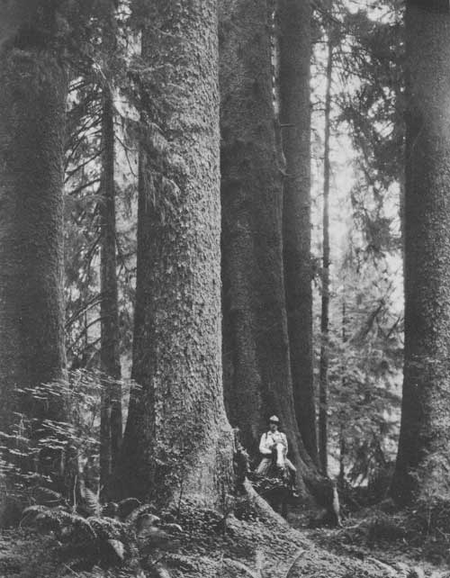
One of the few remaining areas of virgin forest, Olympic National Park presents a glorious example of the original timberlands of the Northwest in the dense growth which surrounds the Olympic Mountains. In the lower valleys of the western slopes, nature has taken advantage of the temperate climate, seasonal rainfall averaging 142 inches annually, and favorable soil to produce the best examples of the unique "rain forests," vast stands of Douglas fir, Sitka spruce, western hemlock, western red cedar and silver fir, with age old individual trees of remarkable size. Some of these tree specimens tower as high as 300 feet, and one, the largest living Douglas fir, measures over 17 feet in diameter.
Unsurpassed elsewhere in the world, these "rain forests" are tropical in luxuriance, with an undergrowth of vine maple, bigleaf maple, ferns and other jungle-like growth. Mosses drape the branches and trunks of trees in fantastic patterns. Seedlings, in ancient succession, take root on fallen trunks which through the centuries rot away, furnishing food for new trees that in turn become forest monarchs. The ground is carpeted with moss in many places 3 to 6 inches in depth.
The heavy rainfall on the western slopes is the result of warm Pacific air currents striking against the Olympic Mountains, which soar nearly 8,000 feet above the sea. Most of this 12 feet of precipitation falls during the winter rainy season. From June 1 to September 1, the average rainfall on the eastern slopes of the Olympics is considerably less than that in eastern United States.
 CENTURIES-OLD TREES GROWING OUT OF FALLEN TRUNK IN RAIN FOREST. Cahalane photo |
THE OLYMPIC MOUNTAINS
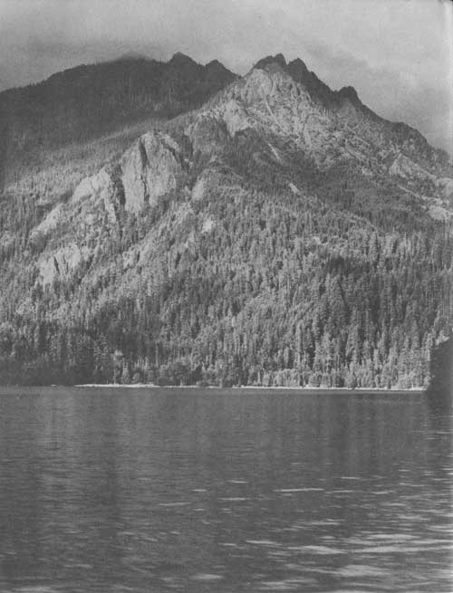
The Olympic Mountains, a rugged mass, are centrally located on the Peninsula. There are no definite ranges; instead, a chaotic jumble of jagged peaks. They attain their highest elevation in glacier-clad Mount Olympus which towers 7,954 feet above sea level. Many of the other mountains also bear large well-formed glaciers which are slowly but continuously gouging their way down the slopes. There are more than 60 glaciers and glacierettes aggregating close to 20 square miles. It is thought that on the Olympics these glaciers like those of the Cascades are receding.
The wilderness of the Olympic Mountains is due in part to the ruggedness of the region and in part to the dense vegetation. The mountain mass rises above an uplifted peneplain remnants of which can be seen in the outer portions of the uplift. The higher elevation of the mountains is due either to greater uplift and more extensive erosion or to the fact that its mass never was reduced to the peneplain level.
The mountains are a complicated mass of sedimentary rocks which were invaded by molten masses, after which the whole was intensely folded and the rocks metamorphosed.
WILDLIFE SANCTUARY
The unique wilderness aspects of Olympic National Park provide a proper setting for a distinctive community of animals that now receive adequate protection. The peer of this animal kingdom is the Roosevelt elk, native of the Olympic Peninsula but now nearly extinct in other areas. Large bands of these elk are seen during the summer months along the river bars and in the open, high country, particularly on the western slopes. Their number is estimated at over 3,000.
The more fortunate park visitor may glimpse a cougar or coyote, but rarely. Black-tailed deer are numerous on the northern and eastern slopes, and black bear often are seen, especially when the berries ripen on the mountain meadows. Other animals found in the park include squirrels, raccoons, skunks, marmots, mink, otter, beaver, and many others. Mountain goats are believed to be increasing. The eagle, hawk, and raven nest high among the peaks, while grouse commonly are seen along the trails.
WILDFLOWERS
Beautiful wildflowers carpet the alpine meadows in riotous color, their blooms representing hundreds of flower species, more than 20 of which are not found elsewhere in the world. The flowers thrive both in the areas of heavy rainfall and those of light rainfall. Heavy mountain snows protect the plants in winter and furnish an abundance of moisture, contributing to their profuse growth in the summer sunshine.
LAKES AND STREAMS
The Olympic Mountains are studded with numerous mirror-like lakes. Lake Crescent, at the northern end of the park, is one of the most beautiful mountain lakes in the United States. Lake Quinault and Lake Cushman border the corners of the park at the southwest and southeast, respectively.
Many rivers, with their cataracts and falls, wind through the deep tortuous canyons and the wider valleys. Although fed by live glaciers, many of the streams are not heavily burdened with glacial silt, but are clear. Their Indian names often indicate the character of the rivers; for example, Sol Duc means "sparkling water."
SITKA SPRUCE IN THE HOH VALLEY. Asahel Curtis Photo
ROADS AND TRAILS
Olympic Highway, U. S. 101, leaves the Pacific Highway, U. S. 99, at Olympia, Wash., and encircles the Peninsula, passing through the towns of Shelon, Hoodsport, Sequim, Port Angeles, Forks, Aberdeen, and Hoquiam for a distance of about 368 miles. Approximately 15 miles of the highway are in the park. It passes along the south shore of Lake Crescent for a distance of 12 miles.
Spur roads branch from the Olympic Highway and lead up most of the main rivers through charming wilderness within the park.
Trails lead into and through the park from the ends of the spur roads and make accessible much of the wilderness area. More than 390 miles of trails have been constructed. The trails are safe and passable for both foot and saddle parties.
HURRICANE RIDGE ROAD—This winding mountain road leaves Olympic Highway 11 miles south and west of Port Angeles and follows the Elwha River 27 miles to Obstruction Point, affording an excellent panoramic view of Mount Olympus, Bailey Range, Mount Anderson, Strait of Juan de Fuca, Vancouver Island, Victoria, B. C., and Port Angeles. Trails branch off as follows:
Long Ridge-Bailey Range Trail, providing one of the finest panoramic views in the park, extends from lower Elwha near Idaho Creek 14 miles up easy switchbacks to Long Ridge toward Dodger Point by a skyline trail; when completed will extend past Mounts Ferry and Carrie to High Divide and Bogachiel Peak, approximately 30 miles.
Elwha River Trail, adjacent to excellent fishing, leaves Hurricane Ridge Road 9 miles from Olympic Highway at Whiskey Bend; to Elkhorn Station, 12 miles; to Hayes River at junction with Dosewallips-Hayden Pass Trail, 17 miles; and to Low Divide Chalet, 27 miles.
Obstruction Point to Moose Lake, 4 miles.
Obstruction Point to Dosemeadows via Moose Lake, foot trail only, 12 miles.
OLYMPIC HOT SPRINGS ROAD—Leaves Hurricane Ridge Road 4 miles from Olympic Highway and extends 7 miles along magnificent Elwha Canyon to Olympic Hot Springs. Trails branch from the road-end as follows:
Boulder Lake, 4 miles; Mount Appleton, 6 miles; Soleduck Park, 12 miles; Seven Lakes Basin, 15 miles, thence to Bogachiel Peak, Hoh Lake, Hoh River, Blue Glacier, and Mount Olympus. The lakes provide fine fishing.
NORTH SHORE LAKE CRESCENT ROAD.—Leaving the Olympic Highway, provides beautiful 6-mile drive through tall timber along the north shore of the lake.
LAKE CRESCENT TRAILS—All are foot trails from Olympic Highway along south shore of the lake. Lake Crescent is the original home of the famous Beardslee trout of the State of Washington.
Storm King Mountain Trail leads from near Storm King State Fish Hatchery and Rosemary Inn to Storm King Mountain, 2-1/2 miles. Mountain goats are often seen along this trail.
Marymere Falls Trail from near Rosemary Inn along Barnes Creek to falls, 3/4 mile.
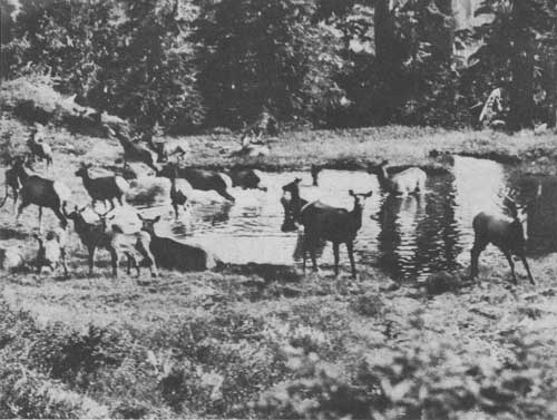 ROOSEVELT ELK AT STALDING CREEK BETWEEN QUINAULT AND QUEETS RIVERS. Asahel Curtis Photo |
SOL DUC HOT SPRINGS ROAD—Leaves Olympic Highway 30 miles west of Port Angeles and follows the Soleduck River 12 miles, through green forest in the park, to Sol Duc Hot Springs and 2 miles beyond. Trails branch out as follows:
Deer Lake Trail, from the end of the road to Deer Lake, 6 miles; to Bogachiel Peak, 10 miles. Roosevelt elk occasionally are seen. From the peak a magnificent panorama is spread—the Pacific Ocean with historic Destruction Island to the west, Mount Olympus from across the mile-deep Hoh River Canyon to the south, and north across the Strait of Juan de Fuca to Vancouver Island; from here also is a beautiful view of the more than 20 lakes in the Seven Lakes Basin.
Trails via Deer Lake and Bogachiel Peak, from road to Seven Lakes Basin and excellent fishing, 8 miles; Hoh Lake, 12 miles (good fishing); Hoh River, 17 miles; Olympus Ranger Station, 17-1/2 miles; Blue Glacier, 24 miles; Jackson Ranger Station at end of Hoh River Road, 26 miles. Soleduck River Trail, from road to Soleduck Park, 7 miles; to Olympic Hot Springs via Mount Appleton, 13 miles; to Bogachiel Peak, 13 miles.
Trails from Deer Lake Trail to Bogachiel River at 21-Mile Shelter, 12 miles; to end of Bogachiel River Road, 32 miles.
BOGACHIEL RIVER ROAD.—Follows Bogachiel River for short distance from Olympic Highway into "rain forests" typical of western Olympic Peninsula.
Trail leads across to Soleduck and Hoh River Roads.
HOH RIVER ROAD—Leaves Olympic Highway 14 miles south of Forks and follows the Hoh River 18 miles to Jackson Ranger Station in the "rain forest." From Jackson Ranger Station is the most accessible route to Mount Olympus. Trails branch as follows:
Mount Olympus Trail, from Jackson Ranger Station to Olympus Ranger Station, 9 miles; to Blue Glacier, 17 miles; to the summit of Mount Olympus, 21 miles,
QUEETS RIVER ROAD—Leaves Olympic Highway 7 miles from the Indian village of Queets and extends 12 miles up the Queets River, ending at Kelly's Ranch just outside the park.
Trails lead up the Queets River and along Sams Creek and Tshletshy Creek over to Quinault River. Largest known Douglas fir tree, over 17 feet in diameter, located close to the Andrews' place on Queets Trail.
NORTH SHORE QUINAULT ROAD.—Leaves Olympic Highway 3 miles north of Quinault and follows the North Fork Quinault River 23 miles to the North Fork Ranger Station.
An 18-mile trail extends from North Fork Station to Low Divide Chalet and cabins.
Trails branch from the Low Divide Trail to Reflection Lake, Irely Lake, Paradise Valley, Three-prune Basin, Stalding Creek, Kimta Creek Basin, Mount Seattle, Martins Park, Mount Christie, Elwha and Queets Basins, Seattle Creek, and the trail continues on to Hurricane Ridge Road, a total distance of 43 miles.
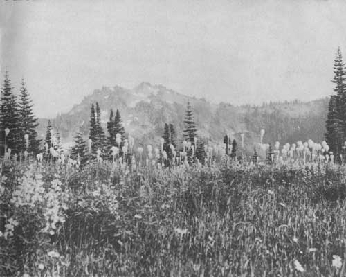
 ALPINE MEADOW AT HEAD OF BOGACHIEL VALLEY LOOKING TOWARD MOUNT TOM. Irving Brant Photo |
EAST FORK QUINAULT ROAD.—Leaves Olympic Highway at Quinault and follows the east fork Quinault River 17 miles to 2 miles beyond Graves Creek. Trails extend as follows:
East Fork Road to Enchanted Valley Lodge, 13 miles.
Other trails lead to Anderson Glacier, 21-1/2 miles; Marmot Lake, 23 miles; Skokomish Road, 43 miles; Dosewallips Road, 32 miles; and Duckabush Road, 47-1/2 miles.
NORTH FORK SKOKOMISH ROAD.—From Hoodsport, extends past Lake Cushman 19 miles to point 3 miles above Staircase Camp, near beautiful Staircase Rapids. Trails are as follows:
Marmot Lake, 16 miles; Heart Lake (fishing), 17-1/2 miles; Lacrosse Lake, 17-1/2 miles; Enchanted Valley, 30 miles.
Skokomish Trail also connects with the West Fork Dosewallips and Duckabush Trails.
DUCKABUSH RIVER ROAD.—Leaves Olympic Highway 12 miles north of Hoodsport and extends 6 miles through logged-off land to trails which lead from Duckabush Road as follows:
Duckabush Camp, 17 miles; Marmot Lake, 20-1/2 miles; Heart Lake, 21-1/2 miles; to Mount Lacrosse Trail, 15 miles; West Fork Dosewallips, via Mount Lacrosse Trail, 21-1/2 miles.
STORM KING MOUNTAIN ON LAKE CRESCENT
DOSEWALLIPS RIVER ROAD.—Leaves Olympic Highway 15.7 miles north of Hoodsport at Brinnon and 61 miles south of Port Angeles, and extends along the Dosewallips River for 15 miles, ending at Dosewallips River Trails, in an area of fine timber (mostly Douglas fir), wildflowers, and plants of transitional zone. Dosewallips Falls. Trails are as follows:
Dosemeadows Trail, to alpine meadows below Mount Claywood, 18 miles.
Dosewallips Road to Greywolf Trail, 14 miles; to Greywolf Shelter, 21 miles.
Hayes River Trail, to junction of Elwha Trail on Elwha River (good fishing), 27 miles.
Dose Forks Trail to junction of West Fork Dosewallips and Dosewallips River Trails, 3 miles.
Graves Creek Trail, to end of East Fork Quinault Road, 32 miles.
Other trails lead to Diamond Meadow, 8 miles; Honeymoon Meadows, 10 miles; Mount Lacrosse Trail, leading to Duckabush Trail, 10 miles; Anderson Pass, 12 miles; Anderson Glacier, 13-1/2 miles; Enchanted Valley, 19 miles.
DEER PARK ROAD.—Leaves Olympic Highway 5 miles east of Port Angeles and extends 17 miles to Deer Park, elevation 5,400 feet; a winter sports area.
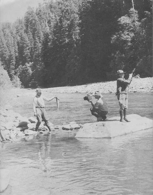
FISHERMEN IN QUEETS RIVER. Irving Brant Photo
ADMINISTRATION
The representative of the National Park Service in immediate charge of Olympic National Park is the superintendent, Preston P. Macy, with headquarters in Port Angeles, Wash.
During summer months, park rangers are stationed at Jackson Ranger Station, North Fork Guard Station, Staircase Camp, South Fork Quinault Station, Eagle Ranger Station, Sol Duc Hot Springs, and at Port Angeles.
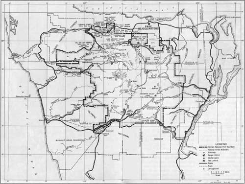
MAP OF OLYMPIC NATIONAL PARK
(click on image for a PDF version)
HOW TO REACH THE PARK
Olympic National Park is easily accessible from Seattle, Tacoma, and Olympia, Wash., Vancouver, B. C., and other northwest cities. Motorists may enter the Olympic Highway by way of Olympia. Ferryboats run on regular schedules from Seattle, Ballard and Edmonds, across Puget Sound to Port Angeles and Port Ludlow. Ferry service also is available from Victoria, B. C., to Port Angeles.
ACCOMMODATIONS
HOTELS, LODGES, AND CHALETS—Excellent hotel accommodations are available both within the park and along the Olympic Highway. Two lodges or chalets are operated within the park under Government contract, one at Low Divide, in the central part, by the Olympic Chalet Co., and the other at Enchanted Valley, in the southeastern section of the park, by the Olympic Recreation Co.
HOTELS.—Within the park, hotel accommodations are available at Lake Crescent Tavern, Rosemary Inn, Storm King Inn, Ovington's, and Graves Creek Inn, all privately operated. Outside the park, hotels are located along the Olympic Highway at Port Angeles, Forks, Aberdeen, Hoquiam, Hoodsport, and Sequim; and at Queets and Quinault near the park boundary. Rates are from $4.50 per day and up per person, American plan.
CABINS.—Housekeeping and overnight cabins are available within the park at Waumilla Lodge, Olympic Hot Springs, Lake Crescent Tavern, Rosemary Inn, Storm King Inn, East Beach Resort, Lake Crescent Auto Park, Ovington's, Lenoir's Resort, Sol Duc Hot Springs, Staircase Resort, and Lake Quinault. Tourist cabin camps are to be found at many places outside the park along the Olympic Highway and the spur roads. Rates are $1 per day and up per person, depending upon furnishings.
AUTOMOBILE CAMPS.—Free camps with complete camping facilities furnished by the Government are located at La Poel, Olympic Hot Springs, Altair, Elwha, and Graves Creek. Campgrounds with simple accommodations are found at Sol Duc Hot Springs, Muncaster, and July Creek near Lake Quinault, and at Jackson Ranger Station.
TRAILSIDE SHELTERS.—Rustic shelters with split spruce and Alaska cedar bunks, water usually available at a creek or river close by, and open stone fire places where the camper may do his cooking, are found at convenient places along the main trails throughout the park.
HORSES AND GUIDES.—Saddle and pack horses and guides are available at the ends of spur roads at Olympic Hot Springs, Whiskey Bend, Sol Duc Hot Springs, North and East Forks of the Quinault River, and Hoh, Bogachiel, Queets, Skokomish and Dosewallips Rivers. Rates average $3 per day for horse and $6 per day for guide. Weekly rates and rates for parties of 5 or more persons may be arranged.
RULES AND REGULATIONS
The following summary of rules is intended as a guide for all park visitors, who are respectfully requested to facilitate park administration by carefully observing them. Complete regulations may be inspected at the office of the superintendent.
PRESERVATION OF NATURAL FEATURES.—The first law of a national park is preservation. Disturbance, injury, or destruction in any way of natural features, including trees, flowers, and other vegetation, rocks, and all wildlife, is strictly prohibited.
REGISTRATION.—All parties entering the park must list their names at the first register maintained in each region visited, indicating the area in which they propose to travel.
FIRES.—Permits must be obtained for building fires except at designated campgrounds. Fire permits are issued in duplicate, the original to the visitor and the duplicate retained by the ranger. Permits should be turned in to the ranger or guard upon leaving the area. Thoroughly extinguish fires before leaving camp.
CAMPING.—Keep your camp clean. Burn trash and garbage in campfires when possible; place cans and residue in containers or garbage pit. If no container is provided, bury the refuse. Do not throw papers or other trash along roads or trails. Carry the material until you can burn it or place in receptacle.
DOGS, CATS, OR OTHER DOMESTIC ANIMALS.—Dogs and cats are prohibited on Government lands in the park unless on leash, crated, or otherwise under physical restrictive control at all times, and subject to permission of the superintendent, secured from park rangers at entrances.
TRAIL TRAVEL.—Hikers and riders shall not make short cuts, but shall confine their travel to the trails at all times. Saddle horses have the right of way over pedestrians.
HUNTING.—Hunting within the park is prohibited. No firearms are allowed, except as provided for through permission of the superintendent secured from park ranger on entering the park.
FISHING.—Washington State fishing laws govern in the park. A State or county fishing license is required. A State license is $3 for residents and $5 for non-residents; a county license for non-residents, $3.
PARK RANGERS.—Park rangers are public servants. They are here to answer your questions and otherwise help you in every possible way. Help them to serve you better by observing all regulations.
| <<< Previous | <<< Contents>>> |
1940/olym/sec1.htm
Last Updated: 20-Jun-2010