|
GRAND CANYON
Circular of General Information 1936 |

|
AUTO TRIPS FROM SOUTH TO NORTH RIM
The trip by auto between the South and North Rims may be made by either of two roads. By far the shorter and easier route is via the Navahopi Road to Cameron, thence over United States Highway No. 89 by way of the Navajo Bridge and Houserock Valley to Jacob Lake, thence south through the Kaibab National Forest to Grand Canyon Lodge. This road is paved from Grand Canyon Village on the South Rim to Highway No. 89 near Cameron, and also from the north entrance park checking station to the North Rim. From near Cameron the road is newly graded and graveled for the entire distance and is passable throughout the year. The distance from the South Rim to the North Rim is approximately 215 miles by this route. Gasoline, oil, and food are obtainable at a number of points en route, such as Cameron, The Gap, Cedar Ridge, Navajo Bridge, Cliff Dwellers, and Jacob Lake. Meals and lodging may also be procured at Cameron, The Gap, Navajo Bridge, and Jacob Lake.
At the west end of the Navajo Bridge excellent accommodations are available at the Marble Canyon Lodge. Gasoline and oil also are obtainable. In connection with the lodge there is a trading post where native Navajo Indian rugs and jewelry may be bought, as well as groceries and supplies. An ample supply of good water is available.
The trip by way of the Navajo Bridge has much of interest to offer the tourist. A considerable portion of the route lies on the Painted Desert, with its colorful mesas, mounds, dinosaur tracks, and petrified wood. From near Cedar Ridge to the Navajo Bridge the road follows the base of Echo Cliffs. At the Navajo Bridge the road turns southwest along the talus slopes of the Vermilion Cliffs and follows them as far as Houserock Valley. This road offers an excellent view across the Painted Desert, and from it may be seen the Kaibab Plateau high above the surrounding country and stretching from north to south along the horizon. Much of this road lies within the Western Navajo Indian Reservation, and it is interesting to see the Indians either following their flocks along the road or congregated at the several trading posts.
For persons interested in the engineering features, the trip is worth while to see the Navajo Bridge alone. This is a structural steel deck-arch of the three-hinged type, built by the State of Arizona in cooperation with the Federal Government and completed in the fall of 1928. The total length of the bridge is 833 feet, and the main span is 618 feet from center to center of end pins. The distance from the roadway to mean low water is some 467 feet, making this one of the highest highway bridges in the world.
The longer route between the rims is via Williams and Kingman, Ariz., Boulder Dam, Las Vegas, Nev., St. George, and Zion National Park, Utah, and Fredonia, Ariz. Good roads are available for the entire distance, which is approximately 618 miles.
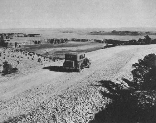
The Navahopi Road through the Painted Desert
AUTO TRIPS TO ADJACENT HOPI AND NAVAJO INDIAN COUNTRY
The Grand Canyon region is one of the few areas where the American Indian still lives in his native state, relatively unchanged by the white man's civilization.
The Navajo is a nomad, a shepherd with the whole of the Navajo Reservation, comprising 24,000 square miles, for his home. The Hopi Indians belong to the Pueblo group, living on three high mesas north of the Painted Desert country. On the easternmost tableland, called the First Mesa, are the villages of Hano, Sichomovi, and Walapai. On the Second Mesa are Mishnonghovi, Shipaulovi, and Shumopavi. The westernmost, or Third Mesa, includes the old village of Oraibi and the more modern communities of Hotevilla and Bacabi. On these mesas the famous Hopi Snake Dances are held each year during August. Eighty miles northeast of Grand Canyon is the village of Moenkopi, situated adjacent to Tuba City, approximately 25 miles from Cameron.
Interesting journeys of one or several days' duration may be made by private automobile or chartered car into this fascinating region, as well as to the Wupatki, Petrified Forest, Rainbow Bridge, and Montezuma Castle National Monuments. These trips into a colorful country of rare climate permit a break in a transcontinental journey that adds much to one's store of memories. The region is filled with the lore of American pioneers, Spanish explorers of many centuries ago, and myths and legends of an Indian occupancy.
SELECTED REFERENCES
GENERAL
Grand Canyon Country. By Tillotson, M. R., and Taylor, F. J. Stanford University Press, 3d ed. 1935.
In and Around the Grand Canyon. By James, George Wharton. Little, Brown & Co. Boston, 1900.
The Grand Canyon and Other Poems. By Van Dyke, Henry. 78 pp. Charles Scribner's Sons, New York, 1914.
The Grand Canyon of the Colorado. Recurrent Studies in Impressions and Appearances. By Van Dyke, J. C. Charles Scribner's Sons, New York, 1920.
GEOLOGY
Ancient Landscapes of the Grand Canyon Region.1 By McKee, Edwin D., Privately Published, Grand Canyon, 2d Edition, 1934.
Tertiary History of the Grand Canyon District with Atlas. By Dutton, C. E. U. S. Geol. Surv. Mon., 1882.
The Shinumo Quadrangle. By Noble, L. F. U. S. Geol. Surv. Bull. No. 549, 1914.
A Reconnaissance of the Archean Complex of the Granite Gorge, Grand Canyon, Ariz. By Noble, L. F. and Hunter, J. F. U. S. Geol. Surv. Prof. Paper 98, pp. 95-113, 1916.
Flora of the Hermit Shale, Grand Canyon, Ariz. By White, David. Publication No. 405, Carnegie Institution, 1929.
The Coconino Sandstone—Its History and Origin. By McKee, Edwin D. Carnegie Institution Publ. 440, Part vii, 1934.
BIOLOGY
Mammals of the Grand Canyon. By Bailey, Vernon. Bull. No. 1, Grand Canyon Natural History Assoc., 1935.
North American Fauna, No. 3. By Merriam, C. Hart. U. S. Department of Agriculture, Government Printing Office, 1890.
HISTORY
First Through the Grand Canyon. By Powell, Maj. J. W. Macmillan, New York. Issued June 1925; reprint April 1935.
Through the Grand Canyon from Wyoming to Mexico. By Kolb, E. L. The Macmillan Co., New York, 1914.
The Romance of the Colorado River. By Dellenbaugh, F. S. G. P. Putnam's Sons, 1909.
INDIANS
The Navajo Indians. By Coolidge, Dane and M. R. Houghton Mifflin Co., 1930.
Ancient Life in the American Southwest. By Hewitt, E. L. Bobbin Merrill Co., 1930.
Havasupai Ethnography. By Spier, Leslie. Amer. Mum. Nat. Hist., vol. 29, Part 3, 1928.
The Rain-Makers. By Coolidge, M. R. Houghton Mifflin Co., 1929.
Traders to the Navajos. By Gillmore, F., and Wetherill, L. W. Houghton Mifflin Co., 1934.
SOUTHWESTERN ARCHEOLOGY
An Introduction to the Study of Southwestern Archeology. By Kidder, A. V. Yale Univ. Press, 1924.
ROAD AND TRAIL GUIDES
Kaibab Trail, South Rim to Colorado River, National Park Service. Desert View Drive, South Rim, National Park Service.
1These publications may be purchased through the Grand Canyon Natural History Association at the park museums or information offices.
| <<< Previous | <<< Contents>>> |
1936/grca/sec5.htm
Last Updated: 20-Jun-2010