|
ROCKY MOUNTAIN
Rules and Regulations 1920 |

|
MAP.
The following map may be obtained from the Director of the United States Geological Survey, Washington, D. C. Remittances should be made by money order or in cash.
Map of Rocky Mountain National Park; 13-1/2 by 20-1/2 Inches; Scale, 2 miles to the inch. Price, 10 Cents.1
The roads, trails, and names are printed in black, the streams and lakes in blue, and the relief is indicated by brown contour lines.
PANORAMIC VIEW.
The view described below may be purchased from the Superintendent of Documents, Government Printing Office, Washington, D. C. Remittances should be made by money order or in cash.
Panoramic view of Rocky Mountain National Park; 14 by 17 inches; scale, 2 miles to the inch. Price, 25 cents.1
This view is based on accurate surveys and gives an excellent idea of the configuration of the surface as it would appear to a person flying over it. The meadows and valleys are printed in light green, the streams and lakes in light blue, the cliffs and ridges in purple tints and the roads in light brown. The lettering is printed in light brown and is easily read on close inspection, but merges into the other colors when the sheet is held at some distance.
1May be purchased also by personal application to the office of the superintendent of the park, in the town of Estes Park, but that office can not fill mail orders.
LITERATURE.
GOVERNMENT PUBLICATIONS.
Government publications on Rocky Mountain National Park may be obtained as indicated below. Separate communications should be addressed to the officers mentioned.
DISTRIBUTED FREE BY THE NATIONAL PARK SERVICE.
The following publications may be obtained free on written application to the Director of the National Park Service, Washington, D. C., or by personal application at the office of the superintendent of the park.
Glimpses of our National Parks. 48 pages.
Contains descriptions of the most important features of the principal national parks.
Automobile road map of Rocky Mountain National Park.
Shows the park road and trail system, hotels, camps, garages, superintendent's office, routes to the park, etc. Also contains suggestions to motorists.
Map of National Parks and National Monuments.
Shows location of all the national parks and monuments administered by the National Park Service and all railroad routes to these reservations.
SOLD BY THE SUPERINTENDENT OF DOCUMENTS.
The following publication relating to the national monuments may be obtained free of charge by writing to the Director of the National Park Service, Washington, D. C.
The following publications may be obtained from the Superintendent of Documents, Government Printing Office, Washington, D. C., at the price given. Remittances should be by money order or in cash.
The National Parks Portfolio. By Robert Sterling Yard, 1917. 260 pages, including 270 illustrations. Pamphlet edition, loose in flexible cover, 35 cents; book edition, containing same material securely bound in cloth, 55 cents.
Contains nine sections, each descriptive of a national park, and one larger section devoted to other parks and monuments.
The Geological Story of Rocky Mountain National Park, hy Willis T. Lee, Ph.D.. 1917. 89 pages, including 101 illustrations and 5 maps. 30 cents.
Contains detailed description of trails and scenic features, as well as very interesting account of the geologic and geographic development of the park.
Mountaineering in the Rocky Mountain National Park, by Roger W. Toll, with 48 illustrations and 2 maps. Price, 25 cents.
Contains directions for climbing principal mountains of the Rocky Mountain Park region. For beginners as well as experienced mountaineers.
BIBLIOGRAPHY.
Bird, Isabella L. A Lady's Life in the Rocky Mountains. 1890. 296 pp.
Bishop, Mrs. Isabella L. (See Bird, Isabella L.)
Chapin, Frederick H. Mountaineering in Colorado.
Dickinson, Anna E. A Ragged Register.
Hewes, Charles Edwin. Songs of the Rockies.
Mills, Enos A. Wild. Life in the Rockies. 1909. 263 pp.
______ Spell of the Rockies. 1911. 301 pp. Illustrated.
______ Rocky Mountain Wonderland. 1915. 362 pp. Map.
______ In Beaver World. 1913. 223 pp.
______ The Story of Scotch.
______ Your National Parks. 1917. 532 pp. Illustrated.
Rocky Mountain Park, pp. 175-189; 491-494.
Stapleton, Patience. Kady.
Steele, David M. Going Abroad Overland. 1917.
Rocky Mountain Park, pp. 125-137.
Yard, Robert Sterling. The Top of the Continent 1917. 244 pp. Illustrated.
Rocky Mountain Park on pp. 16-43.
______ The Book of the National Parks. 1919. 420 pp., 76 illustrations, 16 maps and diagram.
Chapter on Rocky Mountain National Park on pp. 93-117.
OTHER NATIONAL PARKS.
Rules and Regulations similar to this for other national parks listed below may be obtained free of charge by writing to the Director of the National Park Service, Washington, D. C.
|
Yellowstone National Park. Mount Rainier National Park. Yosemite National Park. Mesa Verde National Park. Sequoia and General Grant National Parks. |
The Hot Spring, of Arkansas. Glacier National Park. Wind Cave National Park. Crater Lake National Park. Grand Canyon National Park. |
NATIONAL MONUMENTS.
Casa Grande National Monument
|
|
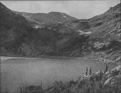
BLUEBIRD LAKE AT THE END OF BLUEBIRD
TRAIL. Photograph by Wiswall Brothers. |
|
|
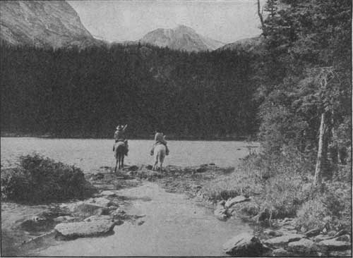
A GLIMPSE OF OUSEL LAKE AND OUSEL PEAK,
10 MILES DISTANT ON THE CONTINENTAL DIVIDE. Photograph by Wiswall Brothers. |
LAKES OF THE WILD BASIN.
|
|
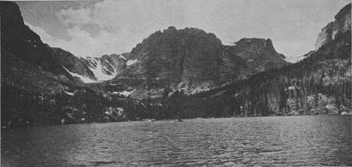
LOCH VALE AS SEEN FROM THE LOCH. Photograph by Willis T. Lee. To the left is the slope of Thatchtop Mountain and a part of Taylor Glacier. In the center is Taylor Peak and the mountain spur that extends from this peak northeastward between Loch Vale and Andrews Gorge. To the right is Otis Peak, with Andrews Glacier in the distance. |
| <<< Previous | <<< Contents>>> | Next >>> |
1920/romo/sec7.htm
Last Updated: 16-Feb-2010