|
BISCAYNE
Biscayne National Monument A Proposal |

|
THE PLAN
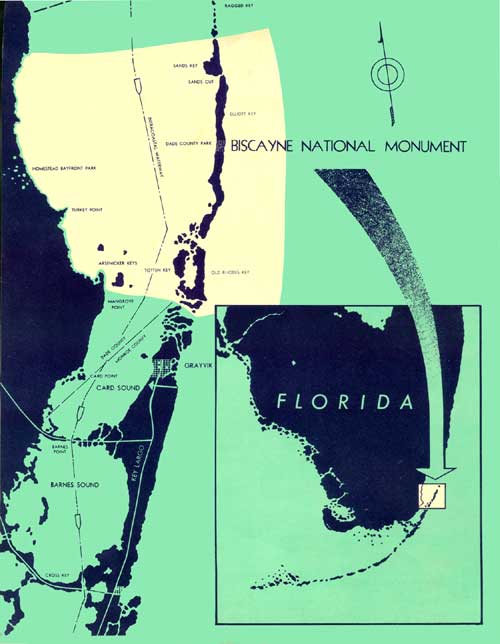
Boundaries suggested in this plan encompass a geographic confine which can be developed and effectively managed for public use and enjoyment. The plan to accomplish this envisions cooperation with several conservation agencies and Dade and Monroe Counties to provide resources, facilities, interpretation, and protection for visitor use. The State of Florida administers John Pennekamp Coral Reef State Park which lies immediately south of the proposed monument. The State Park would not become a part of the national monument. Two units of the Dade County Park System are also found in the vicinity. On Elliott Key a 90-acre primitive area known as Elliott Key Park has been proposed for eventual inclusion in the national monument. Nearby on the mainland, Homestead Bayfront Park would maintain its separate status as a county park and the monument's mainland headquarters would be located in the vicinity of the county park area.
A secondary visitor contact station would be located along Card Sound in the northern part of Key Largo to provide access to the monument from the south.
The National Monument boundaries would extend to the 60-foot depth line in the Atlantic Ocean to the east; between Boca Chita and Sands Keys in the north; paralleling the mainland along the west; through Broad Creek and thence along the northern boundary of John Pennekamp Coral Reef State Park on the south. The western boundary of the monument on the shoreward side of Biscayne Bay would lie east of the established bulkhead line at a distance off shore sufficient to allow riparian owners access to their property by water.
This would preserve for public use a National Monument of about 100,500 acres; 4,000 acres of which would be land and 96,500 acres water.
The underwater resource is fragile. Its preservation must, of necessity, include careful planning for its use. The area preserved in this plan will provide sufficient bay and ocean bottom to spread visitor use over a large area, thereby minimizing man's impact on the marine values. By extending the boundaries to near the mainland in the west, opportunity will also be afforded to protect the submerged lands of the Bay from the effects of unwarranted channel improvements, commercial dredging and filling, pollution or other activities which might alter or upset the marine ecology and underwater circulation patterns.
(click on image for a PDF version)
| <<< Previous | <<< Contents>>> | Next >>> |
proposal/sec8.htm
Last Updated: 17-Sep-2009