|
Bandelier
Historic Structure Report: CCC Buildings |

|
TREATMENT RECOMMENDATIONS
THE SITE
General
The task directive for this study did not include research on specific landscape features such as terrace walls, lighting, and the like. Thus, those features are dealt with only in a general manner. Here specific recommendations are made for vegetation and drainage issues only. These recommendations are to be used as guidelines for preparing and implementing development plans. In the future, additional research must be done before treatment recommendations are made for other landscape elements such as parking configuration, paving materials, circulation, signage, and lighting.
The analysis of various areas as detailed in the preceding pages is one criterion to be used in establishing recommendations for acceptable and unacceptable change. The criteria used for making recommendations are prioritized as follows:
1. Identify and respect original landscape elements, including landscape structures, drainage facilities, and vegetation, based on the mandates of preservation law. This criterion includes removing nonhistoric components that compromise the historic scene, and enhancing or reestablishing historic features.
2. Inventory the need for changing specific landscape features for reasons of public safety, facility protection, and eradication of exotics.
Circulation
Circulation consists of both vehicular and pedestrian routes. The development concept plan currently under way, and other planning documents in the future, should study the history and significance of these routes before any changes are made to the entry road, parking facilities, curbing materials, paving materials, and pedestrian paths.
Landscape Structures and Related Features
Treatment recommendations in this section are general. Future work that affects these structures and features as well as any additions, should be preceded by an inventory of historic and nonhistoric features, cultural landscape context, and preservation alternatives.
Landscape structures and related features have undergone some minor modification through the years. As the remaining historic materials and the replacement materials deteriorate, a greater effort must be made to choose replacement materials that are more compatible with the original materials in color, size, scale, material, and character.
Some minor nonhistoric modifications to the landscape features should be changed soon. Some examples include the television antenna, which should be removed, and light poles, which should be lowered from the visitors' sight. The bright green walk lights should be painted the tan color of the other utilities. The bright yellow fire hydrants should be toned down to a more compatible color such as the tan color of the other utilities.
Vegetation
The long-range goal for vegetative management in the historic district is to restore, to the greatest extent possible, the character of the historic landscape (see "Vegetation" in the "Physical History" section). Recommendations for vegetation improvement include plant removal, planting, and pruning or trimming.
Plant removal should include stump removal, either mechanically or through controlled chemical decay, and should be coordinated with the Southwest Regional Office natural resource specialist. Plant trimming should be done under the supervision of a landscape architect who has full knowledge of the desired results. Planting should also be supervised by a landscape architect and based on an approved planting plan.
A complete list of plants that are found on the site is in appendix A. A preliminary list of replacement plant materials can be found in appendix C. The list should be reviewed for historical accuracy, and specific applications for replacements should be determined in the future.
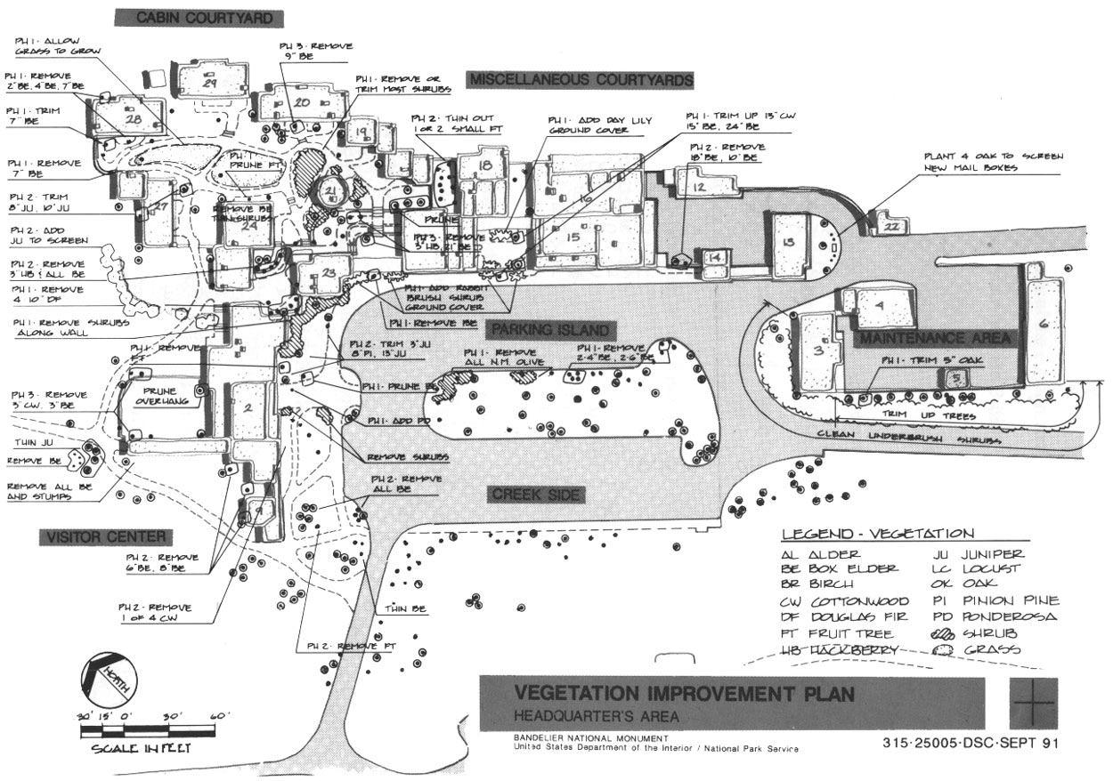
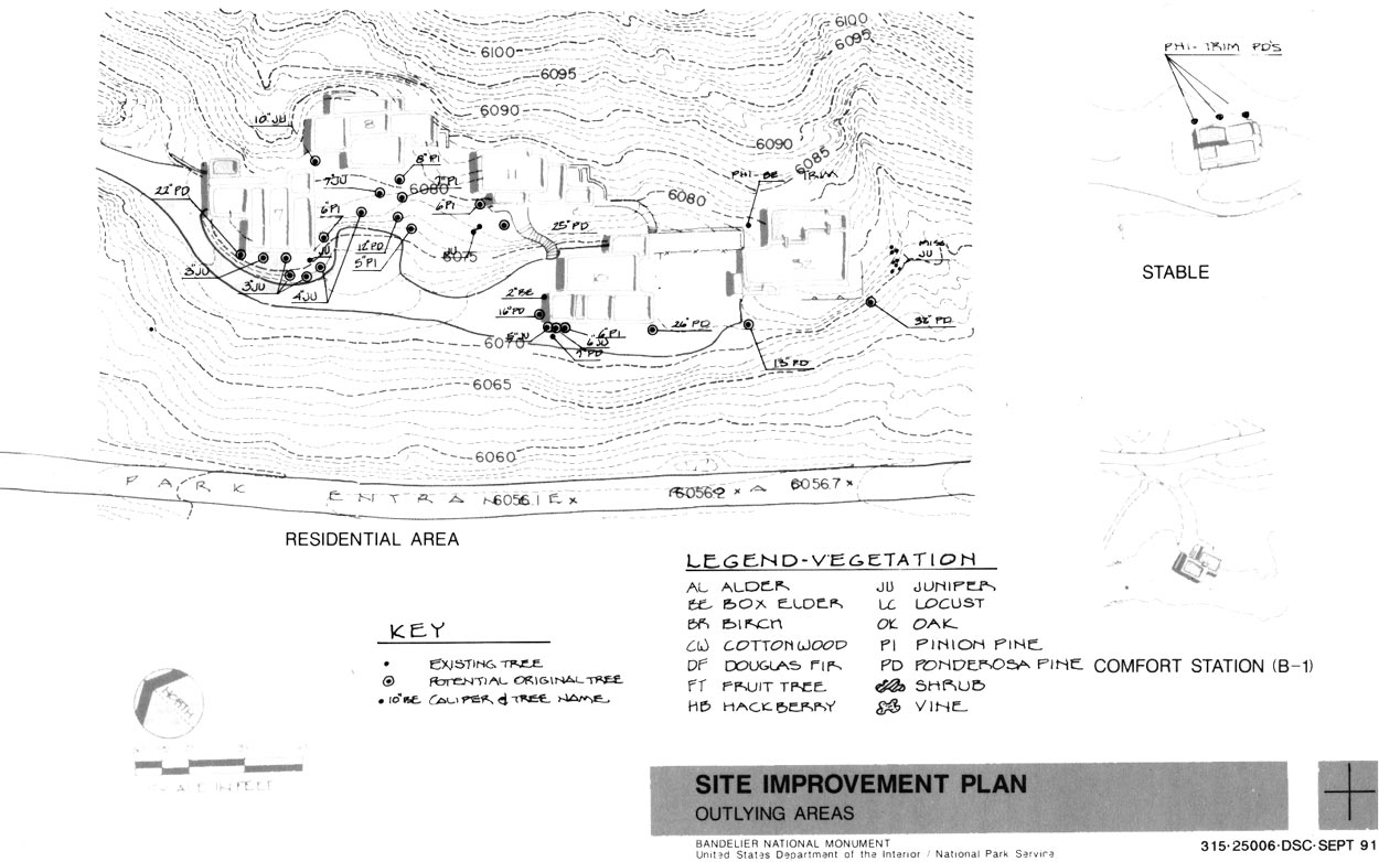
Plant treatment recommendations shown on the vegetation improvement plan for the headquarters area (figure 185) and the site improvement plan for outlying areas (figure 186) are set up in a manner so that the park may start immediate implementation, following the approval of Assessment of Effect forms. These recommendations are based on resource protection, public safety, eradication of exotics, and restoration of historic character. Additional research and development plans are needed to provide the final design and set standards for the level and manner in which the vegetation should be maintained. Also, a cyclic maintenance plan is needed for the vegetation.
|
| Figure 185. Vegetation improvement plan map. (click on image for an enlargement in a new window) |
|
| Figure 186. Site improvement plan map. (click on image for an enlargement in a new window) |
Visitor Center. The plant rehabilitation intent at the visitor center is primarily to remove recent plantings and to expose the building facade by trimming trees and removing shrubs. Also, the intent includes altering the current management practice of fertilizing, mowing, and watering the lawn areas around the visitor center to allow the lawns to return to a more natural, semiarid state. The following rehabilitation steps should be taken around the visitor center:
Remove shrubs at the northeast side.
Remove all box elder at the entrance.
Remove the fruit tree at the entrance.
Trim up the 3-inch juniper, the 8-inch piñon pine, and the 13-inch juniper at the entrance.
Remove all box elder at the southeast side.
Remove the 8-inch box elder against the courtyard wall and the 6-inch and 8-inch box elder on the southwest side.
Remove the apple tree south of the comfort station.
Remove the 3-inch box elder and the 3-inch cottonwood from the northwest side of the courtyard.
Remove all box elder, including stumps, southwest of the visitor center and west of the courtyard.
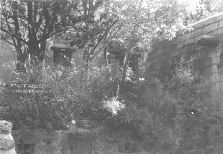
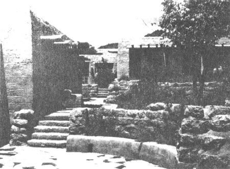
Cabin Courtyard. Plant rehabilitation at the cabin courtyard includes removing rank growth through the walk system, trimming up trees with low branches (raising the crowns of trees), and trimming to open vistas to the cliffs. Trees that adversely affect the buildings should be removed or trimmed.
Remove the 2-inch, the 4-inch, and the 7-inch box elders near B-28.
Trim the 7-inch box elder south of B-28.
Remove the 7-inch box elder north of B-27.
Allow native grass to grow.
Remove nonhistoric shrubs.
Remove four 10-inch Douglas firs.
Prune the fruit tree north of B-24.
Remove three of the four hackberry trees; keep the largest hackberry, adjacent to B-24.
Trim the 8-inch juniper (original tree) southwest of B-27 (figures 187 and 188).
Trim the 10-inch juniper (original tree) north of B-27.
Add 14 five-foot junipers west of B-24 and B-27.
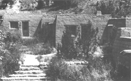
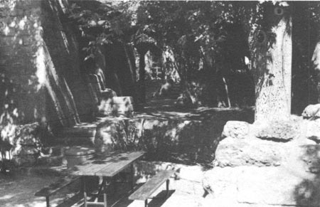
Remove the 21-inch box elder (original tree) only as a last resort; it is cracking the small wall (figures 191 and 192).
Remove the 9-inch box elder south of B-20.
Remove the 3-inch hackberry south of B-21.
|
| Figure 187. Juniper planted in the cabin courtyard, 1940. |
|
| Figure 188. The same juniper in the cabin courtyard, 1988. |
|
| Figure 189. Ponderosa pine in the cabin courtyard shortly after transplanting, 1940. |
|
| Figure 190. The same pine in the cabin courtyard, 1988. |
|
| Figure 191. A forked box elder tree in a planter in the cabin courtyard, 1940. |
|
| Figure 192. The same box elder, 1988. The forked tree now has a caliper of 21 inches and is threatening to crack the small planter. |
Miscellaneous Courtyards. Plant rehabilitation for these courtyards includes trimming up low branches of trees to open vistas to the cliffs. The fruit trees should be pruned with assistance from the Division of Natural Resource Management.
Trim up the 13-inch cottonwood, the 15-inch box elder, and the 24-inch box elder in the dinning courtyard.
Prune the fruit trees.
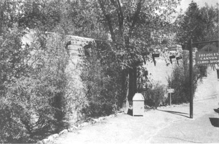
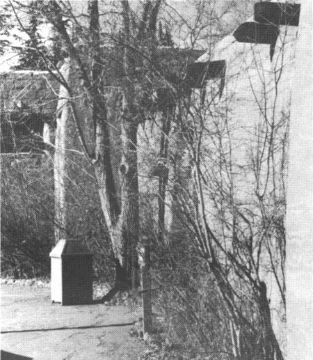
Parking Island. The planting rehabilitation intent for the parking island is to remove rank growth — primarily desert olive and box elder — and remove trees growing too close together (figures 193 and 194).
Remove the two 4-inch and the two 6-inch box elders from the northeast side of the island.
Remove the desert olive.
|
| Figure 193. The wall north of the parking area, 1988. The rank growth of desert olive should be removed to expose the wall. |
|
| Figure 194. The parking area north wall, 1988. The box elder tree should be pruned up to raise the canopy. |
Creekside. Future plans should consider plant materials to discourage pedestrian traffic over erodible soils.
Thin the box elder southeast of the comfort station.
Maintenance Area. Plant rehabilitation for this area consists of thinning out shrub undergrowth along B-3, and possible removal of box elders that are pressing against the wall.
Trim the 5-inch oak south of the south wall.
Remove underbrush and trim up trees from the north corner of B-3 to the south corner of the building.
Monitor the cracked wall near B-14 for continued deterioration. If movement continues, remove 18-inch and 10-inch box elders.
Residential Area. Plant rehabilitation is limited to pruning or trimming in this area.
Trim up the box elder north of B-32.
Stable and Other Outbuildings. Plant rehabilitation for these areas is very limited. Most are very naturalized and need little change.
Trim up the trees adjacent to the stable north wall to open the structure to light and air.
Drainage
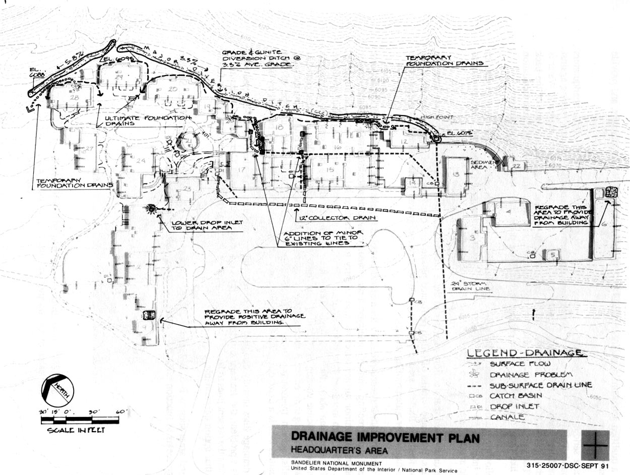
Recommendations to improve drainage and alleviate deterioration of building walls focus primarily on the north (uphill) side of the compound. These recommendations include improving the major diversion ditches, regrading problem areas, containing canale and roof runoff near the diversion ditch, possibly installing foundation drains, and improving minor (6-inch) subsurface drain lines (figure 195). These recommendations are based on a cursory study only. Before any final design recommendations are made, a qualified geotechnical engineer should make tests, recommend design solutions, and provide cost estimates.
The most serious drainage problem is the wet and deteriorating upslope walls of the headquarters compound. This problem is caused by water being concentrated at specific areas and seeping against the foundation walls instead of being allowed to percolate down through the talus material. Water is apparently ponding and saturating the subsoil sufficiently to wet and cause deterioration of the back walls. The solution to this condition during original construction would have been to install foundation drains like those behind B-12. None of the other building plans show this type of drainage.
The following recommendation is based on a general idea of probable cause (not technically specific) and is intended for all the buried upslope walls. Further studies could target the improvement to specific areas where drainage problems have become apparent.
It is recommended that the flow of water to these problem areas be diverted safely away from the buildings. Foundation drains of 6-inch perforated plastic pipe could be installed at the bottom of all upslope footings. Backfill around the pipe could be a coarse gravel. Buried upslope walls could be studied further for waterproofing options.
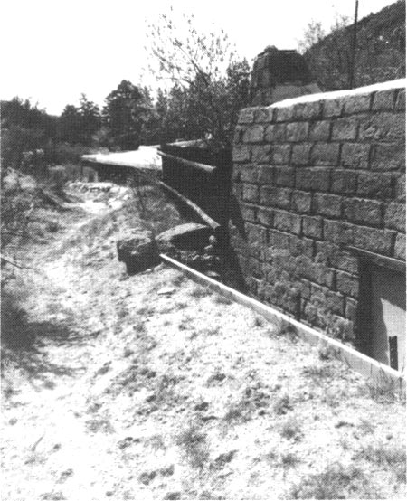
The diversion ditch is needed primarily for major downpours (figure 196). Regrading to a consistent slope and waterproofing with a Gunite-type surface would enable this ditch not only to handle major downpours and minor surface water but also to carry roof drainage safely away from the buildings (figure 195). With increased flow in the diversion ditch, a small maintainable setting basin would be needed downstream above the catch basin. Talus slope creep will always be a problem to grounds maintenance. Concrete coating or "Guniting" the ditch will at least direct the flow of loose particles and make removing them easier. A more detailed study by a geotechnical engineer could show the need for walls, gabion treatments, forced revegetation, and irrigation. Because the upslope of this headquarters area is a maze of buried utility lines, any excavation will undoubtedly be done by hand.
Minor drainage lines initially designed were never totally completed, and where canale-directed roof water is a problem, the drainage structures and lines designed during the CCC era might be installed. Upgrading the present lines to larger size would improve drainage, but the destruction to historic fabric makes that option questionable.
In several areas such as B-6, B-2, and B-23, regrading will take care of wet wall problems. Surface drainage seems to function effectively with only minor sedimentation problems.
|
| Figure 195. Drainage improvement plan map. (click on image for an enlargement in a new window) |
|
| Figure 196. View of 1940 diversion ditch. Porous soil allows very little water to follow the ditch. |
| <<< Previous | <<< Contents >>> | Next >>> |
band/hsr/hsr6.htm
Last Updated: 08-May-2005