|
MESA VERDE
Environment of Mesa Verde, Colorado Wetherill Mesa Studies |

|
Chapter 3
description of the stands (continued)
CANYON-BOTTOM SITE, C—2
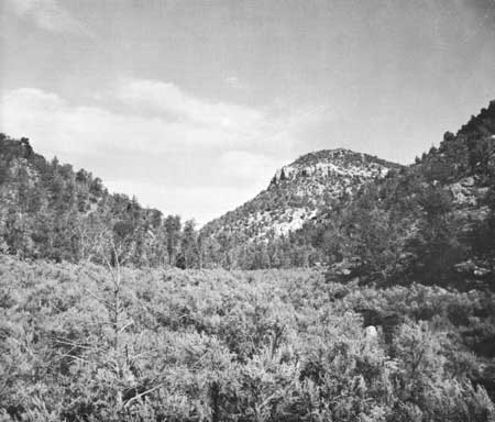
The canyon sites were in Navajo Canyon (figs. 1 and 10), about one-half mile west of park headquarters and 1-1/2 miles southwest of the M—2 site. The canyon-bottom site was on an alluvial terrace at 6,382-foot elevation, about 800 feet lower than the mesa top. The terrace is a remnant of an alluvial deposit that has been dissected by the intermittent stream.
|
| Fig. 10 The Navajo Canyon setting of the canyon-bottom and slope sites, looking north. |
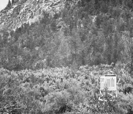
The vegetation of C—2 (fig. 11) is almost a pure stand of big sagebrush, averaging 5 feet high. Sagebrush covers over 75 percent of the stand, and cheatgrass (Bromus tectorum) is the only other plant in abundance. Additional herbs present are listed in table 2. This is a climax stand, and such stands of big sagebrush occur on all the alluvial terraces in the Mesa Verde canyons. On the mesa tops, sagebrush is successional, but in the canyon bottoms it is better adapted to the deep alluvial soils than other species and is able to maintain its dominance.
|
| Fig. 11 C—2, on an alluvial terrace in the bottom of Navajo Canyon, at 6,382 feet elevation, The big sagebrush community is restricted to the sandy soil of the terrace, In the background, upper center, is the environment station for the east-northeast-facing slope. |
The boundary between the sagebrush community and the adjacent pinyon-juniper forest on the canyon slopes is very pronounced (figs. 10 and 11), the line occurring where the coarse colluvium of the talus abuts the alluvial sediments of the terraces. The soils on these terraces are azonal; that is, the profile has an A, C horizon sequence (table 10). These soils were developed on a flood plain or low terrace formed over the bedrock of the rather narrow canyon bottom. Subsequent erosional processes have cut the present intermittent stream channel, which dissects the old flood plain. The soil at the C—2 station is classified as Bankard fine sandy loam. It is a deep, coarse-textured, alluvial soil developing from wind and water-sorted sediments derived from the Mesaverde group.
TABLE 10.—SOIL PROFILE UNDERLYING C—2 BIG SAGEBRUSH/CHEATGRASS STAND*
| Horizon | Depth, inches | Description |
| A1 | 0—4 | Brown (10YR 5/3 dry) to dark brown (10YR 3/3 moist) loamy fine sand; soft dry, very friable moist; weak platy breaking to weak very fine granular structure; many dark flakes of carbonaceous material; noncalcareous; lower boundary clear and smooth. |
| C1 | 4—32 | Light brownish gray (10YR 6/2 dry) to dark gray brown (10YR 4/2 moist) very fine sand; single grained; soft dry, very friable moist; noncalcareous; lower boundary gradual and smooth. |
| C2 | 32—54 | Light brownish gray (10YR 6/2 dry) to dark gray brown (10YR 4/2 moist) very fine sand; single grained; soft dry, very friable moist; weakly calcareous; lower boundary gradual and smooth. |
| C3 | 54—60 | Light brownish gray (10YR 6/2 dry) to dark gray brown (10YR 4/2 moist) moderate to very fine sands; massive; soft dry, very friable moist; calcareous. |
*Soil classified as Bankard fins sandy loam.
The presence of charcoal fragments, described as "many dark flakes of carbonaceous material" in the A1 horizon, is probably the result of a fire that occurred in the station area. Several charred juniper trees were found near the anemometer support.
The soil moisture coefficients listed in table 5 are indicative of the relatively light soil prevalent at C—2. The storage capacity of this soil is very low, a feature detrimental to the growth of shallow-rooted plants.
Two features of the C—2 site—cold night temperatures throughout the year and deep soil—make its growth regime similar to that found in the Sagebrush Desert of the Great Basin, a region where the frost-free season is very short and where frosts occur almost every night in fall, winter, and spring (Oosting, 1956, p. 321). The pronounced differences in temperature between the canyon floor and the other stands are discussed on page 48. Other environmental data are in table 11 and the appendix.
TABLE 11.—SOME CLIMATIC FACTORS OF THE CANYON SITES
| Factor | 1962 | 1963 | ||||
| M—1 | M—2 | M—3 | M—1 | M—2 | M—3 | |
| Air temperature (in degrees Fahrenheit): | ||||||
| January: | ||||||
| Maximum | 48 | 47 | 48 | 48 | 48 | 44 |
| Mean maximum | 39 | 38 | 38 | 34 | 34 | 35 |
| Minimum | -2 | -7 | -2 | -20 | -28 | -19 |
| Mean minimum | 16 | 8 | 16 | 10 | 4 | 12 |
| Mean | 28 | 23 | 27 | 22 | 19 | 24 |
| July: | ||||||
| Maximum | 95 | 97 | 95 | 98 | 97 | 102 |
| Mean maximum | 89 | 90 | 90 | 92 | 91 | 92 |
| Minimum | 51 | 42 | 54 | 54 | 44 | 54 |
| Mean minimum | 55 | 50 | 57 | 59 | 52 | 59 |
| Mean | 72 | 70 | 74 | 75 | 72 | 75 |
| Annual: | ||||||
| Minimum | 97 | 98 | 100 | 98 | 97 | 102 |
| Month | Aug. | Aug. | Aug. | July | July | July |
| Mean maximum | 65 | 65 | 64 | 65 | 65 | 64 |
| Minimum | -2 | -8 | -2 | -20 | -28 | -19 |
| Month | Jan. | Feb. | Jan. | Jan. | Jan. | Jan. |
| Mean minimum | 37 | 30 | 37 | 37 | 31 | 37 |
| Mean | 51 | 47 | 51 | 51 | 48 | 51 |
| Frost-free period, days | 168 | 102 | 173 | 171 | 123 | 184 |
| Last freeze in spring | 22 May | 29 May | 18 May | 12 May | 11 June | 29 Apr. |
| First freeze in autumn | 7 Nov. | 9 Sept. | 8 Nov. | 31 Oct. | 13 Oct. | 31 Oct. |
| Relative humidity (in percentage): | ||||||
| Lowest | 4 | 4 | 10 | 4 | 8 | 10 |
| Month | May | May | May | May | May | June |
| Lowest monthly mean | 37 | 42 | 37 | 29 | 45 | 35 |
| Month | May | Aug. | June | May | June | May |
| Annual mean | 52 | 57 | 56 | 49 | 59 | 54 |
| Precipitation (inches): | ||||||
| Monthly total: | ||||||
| Highest | --- | 2.52 | --- | --- | 4.15 | --- |
| Month | --- | Oct | --- | --- | Aug | --- |
| Lowest | --- | 0.18 | --- | --- | 0.06 | --- |
| Month | --- | June | --- | --- | June | --- |
| Annual total | --- | 13.93 | --- | --- | 14.52 | --- |
| Wind velocity (in miles per hour): | ||||||
| Monthly mean: | ||||||
| Highest | --- | 3.1 | --- | --- | 3.4 | --- |
| Month | --- | May | --- | --- | June | --- |
| Lowest | --- | 1.3 | --- | --- | 1.5 | --- |
| Month | --- | Dec | --- | --- | Feb | --- |
| Annual mean | --- | 2.2 | --- | --- | 2.2 | --- |
Benson (1957, p. 617), in discussing Cold Desert vegetation, states that the typical sagebrush community has a higher water requirement and is therefore restricted to better and usually deeper soils. The general limitation of big sagebrush to this type of site may be due more to its deep root system which can tap water sources not available to many other shallower rooted plants—it is better adapted to these sandy, well-drained soils. Roberts (MS.), in his study of the soils of Wetherill Mesa, says that the occurrence of big sagebrush is closely correlated with areas where the roots can have a deep feeding zone with relatively high available moisture.
The most striking climatic phenomenon in the canyons is the nocturnal flooding of cold air down the drainageways, ultimately flowing along the bottom of the canyon. This produces a pronounced difference in nighttime air temperature and humidity between the canyon bottom and the adjacent slopes. A combination of relatively low winds at C—2 (see appendix) and its topographic setting favors high temperatures during the day and cold nocturnal temperatures. The temperatures regime is thus marked by a diurnal range exceeded nowhere else in the Mesa Verde complex.
Because of the lower minimum temperatures at C—2, the frost-free period is shortened considerably. In 1962, it was only 102 days long, lasting from late May until early September. The 1963 season was longer (123 days), extending from mid-June to mid-October.
The initiation of flowering in the canyon bottom is delayed as a result of the short frost-free period and late-lying snows. In 1963, Phlox hoodii, one of the first perennials to flower on the entire mesa, did not bloom at C—2 until the second week in May; and from the phenological observations made throughout the spring, there seemed to be little plant development prior to that time.
The absence of a variety of herbs is probably due to suppression under the extensive crown cover of sagebrush (Hanson and Churchill, 1961, p. 85) and to competition with cheatgrass. The latter is a winter annual that germinates in the fall and puts on a burst of growth in the spring, when its extensive root system can absorb water from the melting snow. Few herbs can compete with it in vigor during the early part of the warm season.
Cheatgrass plays another potentially critical role in the ecology of this stand type. The grass dries up as the warm season progresses and becomes tinder that ignites easily and often sets fire to the sagebrush. Such fires are common in the West today, but they are of relatively recent origin, since cheatgrass was introduced to North America from Europe only in the 19th century.
| <<< Previous | <<< Contents>>> | Next >>> |
archeology/7b/chap3c.htm
Last Updated: 16-Jan-2007