|
MESA VERDE
Archeological Excavations in Mesa Verde National Park, Colorado • 1950 |

|
The Excavation of Sun Point Pueblo
BY JAMES A. LANCASTER AND PHILIP F. VAN CLEAVE
INTRODUCTION
Pursuant to the authority granted by the Director of the National Park Service (Director Drury's memorandum of February 24, 1950 to the Director, Region Three, National Park Service, Santa Fe), the archeological excavation of a small surface pueblo located approximately one-quarter mile west of Sun Point in Mesa Verde National Park, Colo., was initiated on April 3, 1950.
The specific need for a single ruin of approximately A. D. 1100-1200, which would provide information on this little-known interval and serve as an exhibit for the public, led to the selection of this site.
The latter specification demanded that a ruin fulfilling the other requirements be so located as to fit properly into an orderly sequence of 7 sites representing the chronological development of architecture from the sixth century pithouse throughout the succeeding 7 centuries of occupation of the Mesa Verde. Since previous excavations representing periods as recent as the 10th century were already incorporated into the interpretational plan of the park, the area of search for this "type site" was bounded by the location of the 10th century pueblo excavation (pl. 1, B), the view of the cliff dwellings obtained from Sun Point, and by an "easy walking distance" from that portion of the Square Tower House to Sun Temple view road which connects the series of interpretational sites.
While the site chosen had long been recognized, there is no record of its ever having been given any designation by name or number prior to the preparation of project proposal sheets relating to intended future excavations prepared in June of 1949. Apparently it was overlooked in the course of the Gila Pueblo Ruins Survey of 1929, and again during that institution's work in the summers of 1940 and 1941. (See O'Bryan, 1950, page 25 for the extent of this survey). Convenience of reference in interpretive use recommends the establishment of the name "Sun Point Pueblo" for this site.
Several sites of the approximate period had previously been excavated within the park, but none satisfied the location requirement for convenient visitor use, and few could serve to give period information because of the lack of reports covering the work. Early work by Fewkes in the Mesa Verde included the excavation of Far View House (Fewkes, 1917a, 1917b) in 1916, a small unit pueblo above Square Tower House dug by Linton in 1919 under Fewkes' direction (Linton, 1919), Pipe Shrine House, Far View Tower, and One Clan House in 1922 (Fewkes, 1922, 1923), all of which represent occupations at least in part coeval with the occupation of Sun Point Pueblo. In addition, O'Bryan's excavation of Site 34 (O'Bryan, 1950, p. 62 et seq.), satisfactory except for its isolation, spans the period under consideration. Of work in the Mesa Verde area outside of Mesa Verde National Park, several of the sites (Reed, 1943, notably Sites 1 and 4) bear strong resemblance to Sun Point Pueblo. The connection between kiva and tower which will be discussed later is a trait as yet poorly known from the Mesa Verde but much studied elsewhere in the region to the west of the park. Excepting Fewkes' mention of this condition at Cedar Tree Tower (Fewkes, 1921, p. 91) in Mesa Verde, Martin's work of 1928 and 1929 gave the first considerable information on towers connected to kivas in the literature of the San Juan area (Martin, 1929, 1930). Whether this manifestation appearing at Sun Point Pueblo will prove as constant a feature in the Mesa Verde proper as it does in the somewhat peripheral area of Martin's excavations, will remain for future work to determine.
This report on the excavation of Sun Point Pueblo can serve its greatest value in giving better definition to a few of the problems facing us in the reconstruction of the history of the Mesa Verde people.
SUN POINT PUEBLO
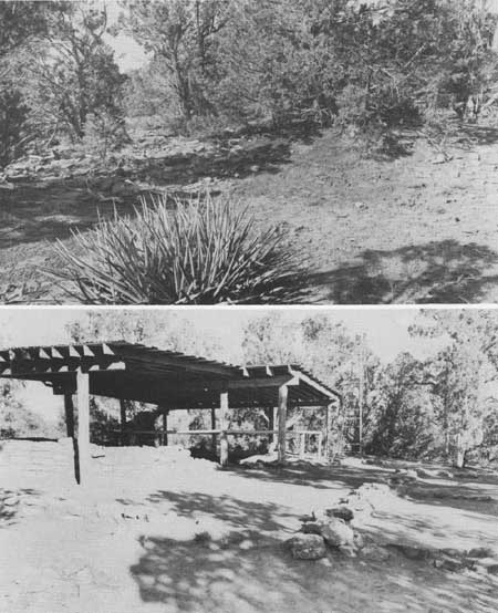
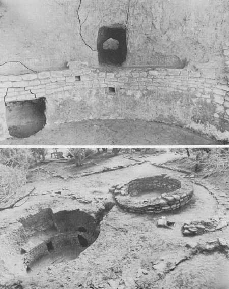
The preexcavation surface indications (pl. 57, upper photograph) at Sun Point Pueblo were of some 10 to 15 room outlines formed about a rectangular court containing vestiges of a towerlike structure close to a kiva depression. While the areal extent of the ruin could be fairly determined, little could be ascertained as to the depth of cultural deposit, although the dearth of rumbled stone made it apparent that no great height of standing wall would be encountered. Evidences with particular bearing upon the period represented were: first, the overall plan of the pueblo with the kiva incorporated within the enclosed court; second, the carefully pecked-faced stones found in association with the exposed top of the double-coursed masonry of the towerlike structure. Little or no significance could be attached to surface porsherds, for the situation of the site, on a south-southeasterly slope, had allowed for a confusing accumulation of drift sherds from an area of long or sporadic occupation to the north and northwest. A total of 42-1/2 man-days was spent in the excavation and stabilization of the site. All work was accomplished by a two-man crew of Navaho laborers under the direction and supervision of the senior author. The ensuing description of the excavations follows roughly the same sequence as did the initiation of the several phases of the work, although actually, in each case, a succeeding phase was initiated before work was complete on a given operation.
THE KIVA-TOWER
Since much of interpretational value of a site would hinge upon the "period characteristics" of the kiva, excavation was started within the kiva depression. Preliminary test trenching had disclosed little fill overlying the rooms surrounding the court, so that clearing the kiva first offered the advantage of allowing slight protection to the remains of neighboring structures during the process of earth removal from the kiva interior.
In the course of excavating the kiva all sherds were saved although the nature of the fill material, being of drift deposit from the sherd area north and northwest of the site, made it impossible to define meaningful stratigraphic layers. Because of the paucity of sherds encountered in the upper fill of the kiva, all sherds from existing ground level to the top of the banquette were considered as one lot and were separated from those found in the lower fill, which extended from the top of the banquette to within 6 inches of the kiva floor. The last intended layer, comprising the 6 inches of fill immediately above the floor, proved to be entirely devoid of sherds or other artifacts.
The kiva manifests practically all the characteristics of a typical "Mesa Verde" or "San Juan" kiva. Some of the variations from type as noted below may be significant time-indicators for the Mesa Verde culture group, but it is thought likely that most are merely reflections of "environmental" differences as compared to the kivas of Mesa Verde cliff dwellings.
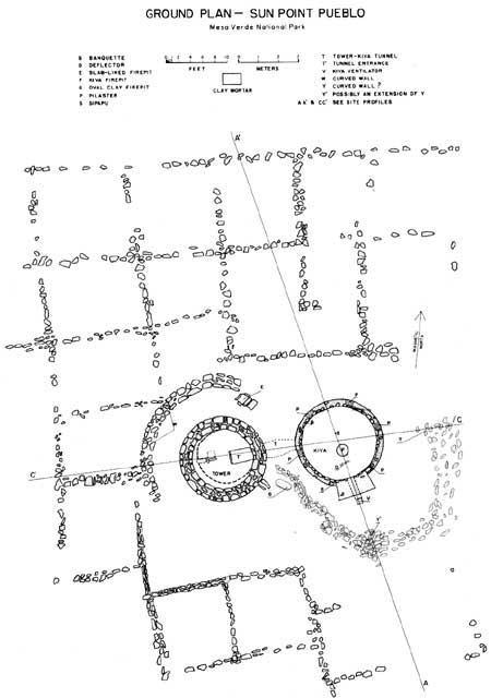
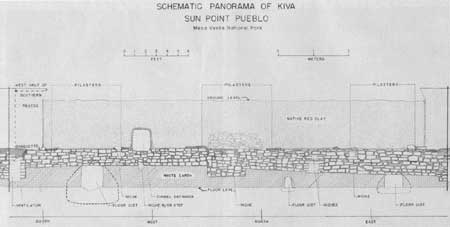
The banquette to banquette diameter of the kiva varies between 12.5 and 13 feet with the banquette itself ranging in width from 10.5 to 13.75 inches. The southern recess measures 3.1 feet in depth along the midline, and orients approximately 31.5° east of south (magnetic reading). The orientation of the kiva within the village is shown in plate 58. Projection of the lines formed by the side walls of the southern recess creates an angle of about 25°, converging at the north wall of the kiva behind the banquette. Although little is left of the 6 pilasters, each is evidenced by a retention of mud on the banquette, and the first pillar east of the recess has 2 of its basal stones still in situ. From these stones and the mortar impressions of others, it appears that the pillars had been constructed of large, uniformly pecked-faced stone blocks.
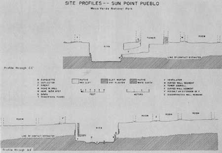
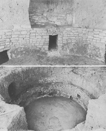
The face of the wall below the banquette level was provided with five niches fashioned in the masonry lining. The niche below the tunnel entrance (shown in pls. 61, upper photograph, and 62) probably functioned primarily as a step. As to the function of niches in general, no new evidence came to light here; however, it would be well to point out the constancy with which a small niche is to be found in the kiva wall in perfect alignment with the ventilator, deflector, firepit, and sipapu. The example in the Sun Point kiva is shown in plates 60, lower photograph, and 62, and is duplicated in at least 4 (and probably all) of the 5 kivas at O'Bryan's Site 34 (O'Bryan, 1950), as well as in the second and third horizons at Site 16 (Lancaster and Pinkley, "Excavation at Site 16", in this volume). The limited information presently at hand suggests that this niche location was rather rigidly adhered to from about A. D. 1050 until around A. D. 1200 with less constancy found in the kivas of the later cliff dwellings. The uniformly small size of niches in this location as compared to others apparently placed at random, lends support to Brew's suggestion that ". . . we may . . . suggest that some of the niches, at least, may have had ceremonial significance in themselves" (Brew, 1946, p. 213).
The wall below the banquette had been plastered at least once, and probably twice, with clay ranging in color from red-brown to olive-brown. The plaster was carried somewhat into the mouth of the smallest of three wall cists (see discussion on p. 93).
The entire clay floor shows a remarkable preservation. The sipapu had been plugged with an inch thick seal of floor clay beneath which was fill of a dark material in sharp contrast to the whiteness of the native calichelike soil into which it had been cut. The firepit is near circular in form, approximately 2 feet in diameter, and forms a shallow basin without any noticeable rim or coping. The deflector had apparently been dismantled, for its location was marked only by three stones bedded in, and just slightly protruding from, the floor.
The horizontal shaft of the ventilator measures 26 inches in height by 14 inches in width at the mouth, and extends 54 inches to the back wall of the vertical shaft following the midline of the southern recess above. The roof of the tunnel shaft is supported by 3 large stone slabs including the 1 which forms the lintel over the door-like opening. These slabs are borne upon the masonry lining of the ventilator side walls. The vertical shaft of the ventilator is so constructed that occasional stones of the facing in the southern recess serve also as facing stones of the adjacent shaft. The masonry lining of the vertical shaft does not extend to the ground level above, nor is there evidence of a stone framing at the ground level. Interior sectional dimensions of the vertical shaft at its base are about 11 by 14 inches, although there is a considerable reducing taper to the upper portion.
While most of the kiva features previously mentioned are considered typical of "Mesa Verde" or "San Juan" kiva constructions, the following are notable departures from, or apparent additions to, "type" form and will be dealt with individually in an effort to suggest possible significances.
(1) Masonry used in the lining of the kiva interior (pl. 60, upper and lower photographs; 61, upper photograph, and 62) is limited in extent. In a typological series of Mesa Verde kivas, one will find examples of an early form in which no masonry is used, the walls being carved into native earth (O'Bryan, 1950, Site 102, kiva). In other cases equally as early, limited amounts of masonry occur under conditions which suggest use only to prevent collapse of weak portions of the native soil. In some instances this may have been done at the time of original construction; while in others, it is reasonable to assume that the masonry was added only when demanded by soil slumping conditions. A third condition, found at Sun Point Pueblo, is one in which masonry is carried throughout the circumference of the kiva, but extends downward from the banquette only deep enough to obtain a firm footing. In the Sun Point kiva this depth was determined by the contact between the crumbly red-clay surface soil and the underlying dense calichelike earth into which the masonry footings were carved. In comparatively late kivas on the mesa top, the masonry will be found to extend upward to the level of the tops of the pilasters, giving full lining from floor to roof (Lancaster and Pinkley, "Excavation at Site 16" in this volume). The culmination of this development is seen in late talus pueblos (O'Bryan, 1950, Site 34) and in cliff dwellings where masonry is often continued from the tops of the pilasters to the ground or court level.
|
|
PLATE 62—Schematic Panorama of Kiva Interior The features labelled here as "floor cists" are more accurately referred to in the accompanying text as "wall cists." (click on image for a PDF version) |
To what extent this apparent refinement of technique is attributable to the necessity of retaining loose fill or dirt, rather than aesthetic or conventional standardization of religious architecture, seemingly remains an unanswered question. It has been suggested (Brew, 1946, p. 214) that the extent of masonry used in kiva lining was merely a practical means of meeting various exigencies of "earth" conditions met with in construction, and not, per se, a standardization capable of time indication. Whether or not a kiva was to be plastered might be an important factor in determining the extent of masonry (in excess of structural need) to be used.
To complete the description of the masonry lining in the Sun Point kiva, it will be noted in plate 60, upper photograph, that both vertical slabs and horizontal masonry were used in facing the walls of the southern recess, while plate 60, lower photograph, shows the extent of masonry above the banquette between pilasters 3 and 4 in the north quadrant of the kiva.
(2) The presence of kiva wall crypts is hitherto unrecorded from the Mesa Verde proper, though both Brew (Brew, 1946, pp. 143-144) and Morris (Morris, 1939, pp. 89-90) encountered cists in kivas which might have been analogous to those in the Sun Point kiva. In all three of the Sun Point kiva cists, the enlarged globular body of the cist extends somewhat below the level of the kiva floor, and is excavated entirely into the calichelike white earth beneath the banquette. The three are extremely variable in size, with maximum diameters ranging from 18 inches (north cist) to 56 inches (west cist). Maximum depth below kiva floor level ranges from 5 inches (north cist) to 18 inches (west cist). The maximum height of the west cist could not be accurately measured since the banquette above had collapsed into the body of the cist; however, the curvature of the upper walls indicates an approximate height of 48 inches. The maximum height of the small north cist is about 18 inches which establishes an approximation of the range for this dimension. The variations among the three cists can be seen in plate 62.
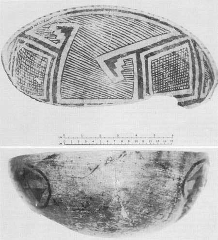
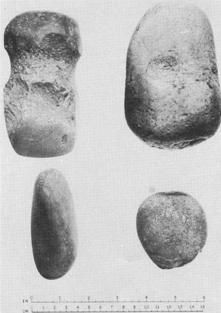
While nothing was found to indicate function of the wall crypts, the one east of the ventilator contained three sherds forming almost one-half of a large, well-made Mesa Verde Black-on-white bowl (pl. 69) and a pecked-grip hammerstone (pl. 66). The half-bowl is undoubtedly the most reliable single dating criterion for the site, and will be dealt with in detail elsewhere.
(3) The pilasters were of slightly atypical form. Fragmentary remains of the pilasters show that they had been formed of large pecked-faced stones in marked contrast to the small blocks used in the banquette facing. The pilasters had been set back slightly from the edge of the banquette, a trait which seems to correlate with small rectangular pilasters in early kivas on Alkali Ridge (Brew, 1946, p. 210), but is commonly manifest in late cliff dwelling kivas of the Mesa Verde. In this and all other discernible features, the pillars are fully characteristic of Mesa Verde Pueblo III, including the widening or flaring from front to back which Brew has considered a significant advance since "The side walls of the pilasters become as the outer sections of radii of the circle" thus bringing the pilasters ". . . into the circular plan of the kiva." (Brew, Ibid.) These details may be seen in plates 60, upper photograph; 61, lower photograph; and 62.
(4) The presence of a tunnel connecting the kiva to a round structure (presumably a tower) has previously been reported from the Mesa Verde (Fewkes, 1921; Reed, 1943) and more notably from the Hovenweep drainage (Martin, 1929, 1930, 1939). However, since Cedar Tree Tower and its associated kiva excavated by Fewkes are not integral parts of a pueblo, this situation was first encountered within the park proper at Sun Point Pueblo. Burgh (Burgh, 1934, p. 34) reported a kiva-tower connection at Far View Tower, but this may be an assumption based on the characteristic kiva-tower connection found by Martin (Martin, 1929, p. 30). There is no reason to doubt that other "kiva-towers" (term by Reed, 1943, p. 59) may exist in the park, for there are numerous unexcavated sites showing towers as surface indications.
Martin refers to "The round tower, subterranean passages (and chambers) and kivas lying to the south, and all forming . . . a psychological unit . . ." (Martin, 1929, p. 19). If we may lift his "psychological unit" slightly out of context and apply it only to the "kiva-tower complex," it will not preclude consideration of Cedar Tree Tower as a parallel of Martin's sites as well as Reed's presumed kiva-towers in the Mancos Canyon, and the unit at Sun Point Pueblo.
Solely on observation of the tower alone, Nordenskiöld (Nordenskiöld, 1893, p. 72) suggested that Cedar Tree Tower ". . . be regarded as a religious edifice." Both Martin (Martin, 1939, p. 476) and Reed (Reed, 1943, p. 13) deny the value of such towers as watch towers, which lends a negative support to their having served as a specialized ceremonial adjunct to the kiva.
At the present time the distribution of this "psychological unit" trait seems better defined in space than in time. Since the trait was not encountered by Morris in the La Plata District, or by Brew at Alkali Ridge, its east-west distribution would bear out Morris' (Morris, in: Martin, 1929, p. 33) suggestion that the kiva-tower is ". . . a local specialization" perhaps more localized than the oft-mentioned tower trait of the San Juan area. There can be little question but what some relationship exists between the kiva-room connection described by Fewkes, (Fewkes, 1909, p. 13) and Prudden (Prudden, 1914, pp. 46-47) and the kiva-tower connection under consideration. While the former trait occurs in known late cliff dwellings, no evidence has yet been reported of the persistence of the latter in cave villages. However, knowing nothing of the specialized use which may have been associated with the kiva-tower, it would be well to mention the possibility that kiva-tower function might have been incompatible with cave situations, and hence they might persist as isolated units upon the mesa top or elsewhere during the period of exclusive cave dwelling occupation. Such isolated towers are, in fact, known to the Mesa Verde, but considerable exploratory excavation would be needed to distinguish "bona fide watch towers" from kiva-tower units. (For discussion of the defensive character of towers, see: Riley, 1950; Schulman, 1950; Lancaster and Pinkley, "Excavation at Site 16," in this volume.)
The exploratory trench intersecting the collapsed portion of the tunnel can be seen at the center of the photo. The slumped condition of wall above the east wall cist can be seen at the extreme left in the kiva interior. The extent of collapse of the west kiva cist can be noted at the right in the kiva interior.
The tunnel connecting the kiva to the round tower was an excavation into native soil with no structural use of masonry or wood. A small portion of the tunnel roof had collapsed near the edge of the kiva. An exploratory trench intersected this collapsed portion as may be seen in plate 61, lower photograph. The tunnel had been enlarged along its midsection so that the entrances from either end formed definite constrictions to the tunnel. The span of double-coursed masonry of the tower structure had apparently aided the support of the tunnel roof at that end. The rectangular manhole entrance from the tunnel into the floor of the tower was only partially masonry lined. No evidence of masonry was found on the lateral walls of the manhole, although the end wall was lined with crude masonry at an irregular depth below the level of the tower floor.
After the kiva-tower passage had been abandoned, a considerable quantity of refuse had been thrown into the tunnel, apparently from the tower end. This lens of debris, lying in contact with the floor of the tunnel, consisted of wood ash in which there was the greatest concentration of bone materials found during the excavation of the site.
Excavation of the tower, which was commenced before the excavation of the kiva had been completed, disclosed the basal portion of a double-coursed masonry building with an outside diameter averaging 14 feet. The stone work of the circular wall was of carefully pecked-faced blocks. The greatest depth of fill was found overlying the interior floor level where it reached a maximum depth of 37 inches. Since no standing wall of the tower projected above the ground level at the start of the excavation, this figure will suffice as well for the maximum height of standing wall. Wall thickness averages 2 feet for the double-coursed width. There is indication of a former doorway almost directly over the tunnel passage to the kiva.
The floor of the tower was made of packed red clay, in part poorly preserved. A single slab on edge seemed to extend the midline of the tower-kiva tunnel toward the opposite side of the tower. No purpose could be suggested for the presence of this slab at the time the floor was first exposed, for it seemed to constitute the only irregularity in an otherwise continuous floor level. At the floor level to the south of the doorway the wall is soot blackened and fire reddened through an arc of 4 feet, although there was no sign of a conventional firepit. A slight accumulation of white wood ash was found on the floor more or less centrally located in respect to the arc of fire discoloration, but of too small an extent to account for the more extensive evidence of fire.
The excavation of the tower was considered complete with the exposure of the floor level described above. However, questions concerning the function of the protruding slab and the largely unaccountable fire discoloration around the south quadrant of the wall led to further exploratory excavation beneath the floor level early in 1952. Description of this work and the evidences encountered will be dealt with in a later section.
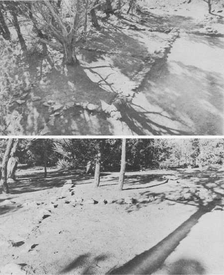
In clearing the area immediately surrounding the tower structure, two outdoor firepits were uncovered, as well as the remnant of a secondary circular wall concentric to the wall of the tower. So little remains of this secondary wall that it is impossible to determine whether or not it was contemporary with the tower structure (see plan, pl. 58). It can be noted from the plan of the site that this outer circular wall, if completed in near-circular form, would overlap the edge of the kiva with a small arc of its outer footing. Some further consideration of this outer wall will be found in a later section of this report describing features found beneath the last-used floor of the tower structure (p. 101).
THE VILLAGE PROPER
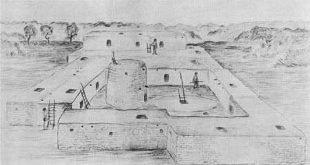
The clearing of the area occupied by the pueblo proper disclosed very little additional information regarding structural derail. At no point was the fill overlying the presumed occupation level within the room outlines more than 6 inches in depth. The presence of the two firepits close to the tower serve as the best indication of the occupational level in absence of any such features inside of the room enclosures. The stones that outlined house floor areas were occasionally hard to distinguish from scattered rocks that littered the site. An occasional stone set firmly into the ground surface and rare instances of a two-course height of surviving wall serve to define the room areas. Any estimate of the total number of rooms would be merely guesswork, although some thing more than the "10 to 15 room outlines" mentioned previously are indicated in the site ground plan. While no evidence survives in proof, one might suspect the former existence of a row of rooms or at least a wall bounding the east side of the village and court. It is probable that the north row of rooms as indicated (pl. 58) represents the edge of the village on that side, but elsewhere the remains are too vague to allow outer wall determination. Obviously then, the artist's reconstruction of Sun Point Pueblo (pl. 72) is based more upon typologic supposition than factual evidence, and was produced primarily for interpretive exhibit to visitors at the site.
OBSERVED EVIDENCE AND ARTIFACTS
Because of the dearth of true artifacts recovered in the course of excavation at Sun Point Pueblo, all internal evidence observed during the excavation, as well as the sherds and unworked bone, will be considered under this heading along with the few stone and bone articles of manufacture. Table 9 provides easy reference to all the cultural remains recovered in general reference to provenience of specimens. In the following narrative presentation of the cultural manifestations the same general order will be followed as was used in the foregoing description of the site: kiva, tunnel, tower, court, and general village proper.
Table 9.—Tabulation of Artifacts Recovered—Sun Point Pueblo
| Location | Pottery | Stone | Bone | Plant |
| Kiva: | ||||
| Upper fill | 111 sherds | |||
| Lower fill | 205 sherds | Chipped point fragment | ||
| Floor | Water worn pebbles (2) | Awl, bobcat, femur. Worked bone, turkey. | ||
| South recess | Worked sherd | |||
| Southeast cist | 1/2 bowl, Mesa Verde Black-on-white. | Pecked grip hammer | ||
| Tunnel: | ||||
| Ash lens on floor | 14 sherds | Metate Manos (2) |
Worked bone, deer (?) 16 bone fragments | |
| Tower: | ||||
| Fill | 14 sherds | |||
| Floor | 5 sherds | Chipped point Mano | ||
| Subfloor | 12 sherds | Charred corn cobs (6). Charred twigs (12). | ||
| Oval firepit | 16 sherds | |||
| Slab-box firepit | Eyed awl, deer bone (?) | |||
| Court area | Grooved axe | |||
The Kiva
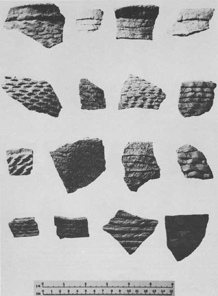
Much of the upper fill in the kiva was of water-borne drift including both soil and sherds. A total of 111 sherds represents a range in decorated wares from Mancos Black-on-white to good Mesa Verde Black-on-white; corrugated wares show variation from narrow, partially obliterated coils to perfect, carefully indented configuration. Certainly the range of occupation span which might be inferred from the range of pottery types cannot be substantiated by any other evidence. Only one sherd was encountered which might be considered intrusive culturally, it being a small brown-ware sherd with finely divided chalky white temper.
Large stones or building blocks were noticeably absent in the upper fill material.
From the level of the banquette downwards the lack of tumbled building stone became even more conspicuous. The almost total absence of pilaster stones was the first indication that the kiva had been dismantled by salvage operations at, or subsequent to, abandonment. While there were almost twice the number of sherds found in the lesser volume of the lower fill as compared to the upper fill, even here the range in types represented was wholly inconsistent with the other evidences pointing to a very limited period of occupation. Decorated and corrugated sherds showing the range found are shown in plates 70 and 71, respectively. A basal fragment of a large chipped point was found in the lower fill and constituted the only nonceramic artifact encountered in the kiva fill (pl. 65, lower left).

|
|
PLATE 65—Miscellaneous Objects Upper left—Eyed awl from slab-lined firepit. Upper right—Awl of bobcat femur from kiva floor. Center—Small worked sherd from floor of southern recess in the kiva. Lower left—Chipped point fragment from lower fill in the kiva. Lower right—Chipped point from tower floor. |
Having recognized the insignificance of sherds in the kiva fill from the start, the bottom 6 inch layer above the floor was removed separately in an effort to obtain a series of sherds which would show association with the period of occupation of the village. However, this bottom 6 inch layer was comprised of roof clay, decomposed vegetable matter (not timber), and loose earth presumed to have been from the fill material immediately above the cribbed kiva roof at the time the dismantling operation was commenced. Not a single sherd was found in this layer or in contact with the kiva floor.
With the exception of that section of the floor beneath, and between, the second and third pilasters (northwest quadrant), the kiva floor was clear of any refuse or artifact beneath the litter-fall of the dismantled roof. The two water-worn pebbles shown in plate 66 were found on the floor just north of the tunnel entrance. A broken fragment of the distal end of a turkey tibiotarsus, which shows random scoring of the shaft just above the articular processes and an abraded smoothness along one lateral edge of the fracture (probably a badly damaged bone awl), was found a few inches north of the pebbles. A complete awl fashioned from the proximal end of a bobcat femur (pl. 65) was the northwesternmost of the artifacts, all of which came from an area of approximately 10 square feet.
In cleaning out the southern recess, the small rectangular worked sherd shown in the center of plate 65 was found in contact with the "floor" of the recess.
The remarkable preservation of the kiva floor and the direct contact between floor and vestiges of roof clay would seem to indicate that no appreciable lapse of time could have existed between abandonment and removal of the kiva roof.
From the ground plan of the site (pl. 58) it will be noted that there is a somewhat crescent-shaped but irregular mass of stones surrounding the south portion of the kiva. The lack of stones in the kiva fill suggests the possibility that stones accumulating on the kiva roof during dismantling of the tower were tossed off to form the encircling ring when the kiva roof salvage operation was begun. It is equally possible that this ring of stones is the remnant of one or more walls so badly demolished as to defy determination.
In cleaning out the three kiva cists, only the large one east of the ventilator produced significant evidence of artifacts. The pecked-grip hammerstone shown in plate 66 and the restored half-bowl of Mesa Verde Black-on-white shown in plate 69 were found on the floor of this cist. The fill within the cist, overlying the hammerstone and sherds, consisted in part of fragments of dried but unburned roof clay which bore impressions of small roofing sticks. This circumstance points to deposition of the articles before the roof of the kiva was thoroughly dismantled and effectively precludes fortuitous introduction of the artifacts after abandonment of the site.
|
|
PLATE 66—Objects of Stone Upper left—Full-grooved axe from court just north of the tower. Upper right—Pecked-grip stone hammer from large east wall cist in the kiva. Lower left and right.—Waterworn pebbles from the kiva floor. |
The Tunnel
The ashy lens of trash found on the floor of the tunnel between the kiva and tower (see p. 95) contained 14 sherds representing not more than 9 vessels; a broken (but complete) flat slab metate; one thin bevelled mano; one massive unfinished mano (?) and an accumulation of "waste" or "table scrap" bones. The latter constitute parts of 1 or 2 cottontail rabbits; 1 or more unidentified spermophiles; 1 exceedingly young fawn deer; 1 mature deer; and 1 large bird, presumably turkey.
The mandible, scapula and radius (?) of the fawn are so incompletely ossified, and hence fragile, that one might suspect they had been deposited here immediately upon dismemberment of the carcass. Certainly the three parts preserved in association would suggest that the dismantling of the site took place during the fawning season or only slightly after, for there could not have been any traffic through the passage after the deposition of the ashy lens of refuse.
The mature deer bone fragment is the only piece that shows evidence of having been worked, and that only superficially. It is doubtful whether it was ever intended as a tool, but instead may be a splinter discarded in the working of a large bone.
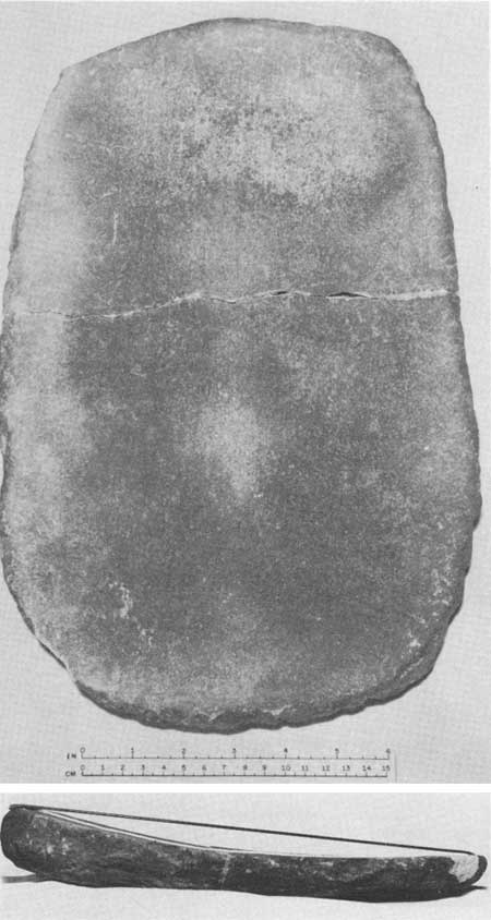
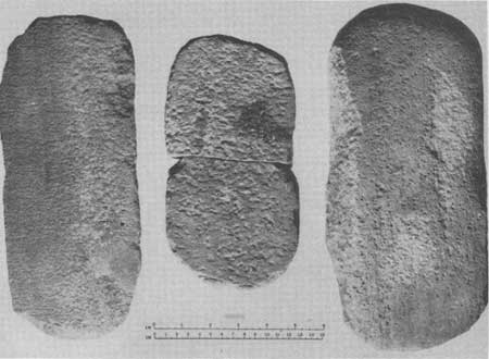
The slab metate and manos are shown in plates 67 and 68, respectively. All three are of sandstone. The fracture of the metate might have been caused by excessive heat, for the working face and edges are somewhat heat discolored and soot darkened. The thin mano is provided with a single working face but has the triangular cross section typical of many Mesa Verde manos. The large mano(?) does not give evidence of having been used and is likely an unfinished blank.
|
|
PLATE 67—Slab Metate Upper left photograph—Face view of the slab metate found in the tunnel passage. The upper portion of the metate above the crack is foreshortened in this view. Upper right photograph—Lateral view of metate showing depth of concavity resulting from wear in use. |
|
|
PLATE 68—Manos from Sun Point Pueblo The broken example in the center was found on the floor of the tower, while the bevelled mano at the left and the unfinished mano (?) at the right are from the trash deposit found on the floor of the kiva-tower passage. |
The Tower
The fill material in the tower yielded 14 sherds which represent not less than 10 vessels. Since the remains of the tower wall would have precluded drift from the surrounding area, it is thought likely that a part, or all, of these sherds originated as chinking material in the dismantled upper portion of the tower structure, becoming admixed with the clay in which they had been imbedded as the courses of stone were removed in salvage operations. A few chinking sherds remain in the surviving courses of the standing wall. The absence of any noticeable trash or wind-blown debris beneath the clay and spalls of the dismantled wall again tends to support the idea that salvage operations were undertaken at the time of abandonment.
Five additional sherds and a slightly damaged projectile point were found in direct contact with the tower floor along with both halves of a broken sandstone mano. The point and broken mano are shown in plates 65 and 68, respectively.
As was mentioned earlier, excavation in the tower was discontinued and considered complete with the exposure of the last occupation level, but subsequent excavation beneath this floor early in 1952 led to partial clarification of two questions. Removal of the floor disclosed a great ash deposit corresponding in extent to the arc of fire discoloration on the tower wall (see p. 95), thus solving the problem of origin of the fire reddening and soot blackening of the wall which was obvious but largely unexplainable at the level of the last-used floor. The quantity of ash would indicate a tremendous fuel consumption in this area, yet there is nothing which could be considered a fashioned firepit. The ashes merely accumulated in a crudely gouged groove or trough of irregular form which followed the curvature of the tower wall. Noteworthy inclusions in this ash deposit were 6 sherds of Mesa Verde Black-on-white; 1 Corrugated sherd; 4 sherds of Black-on-white vessels of types indeterminate because of small size or poor condition; and a total of 18 charred fragments of plant remains, including 6 corncobs and tiny sections of small sticks 1-1/2 inches in diameter or less.
The vertical slab which had been protruding through the tower floor proved to be a vestige of a slab-lined bin whose floor corresponded in level to an earlier underlying floor. There had been two of these bins (see dotted line indications in pl. 58) but it is impossible to determine with certainty whether their use was associated with either of the floors exclusively, or with each in turn. It is probable that the bins had been dug through the upper floor and that happenstance alone accounts for the slab bottom of each coinciding with the underlying earlier floor.
Elsewhere beneath the floor, chunks of unburned roof clay were encountered in the fill suggesting that the original roof had been repaired or replaced prior to the establishment of the last used floor.
An unexpected structure, brought to light by the removal of the tower floor, was an underlying circular wall beneath the footings of the tower proper. This wall, of a diameter slightly less than that of the upper tower, is not quite concentric to the latter so that it seems to form a low benchlike shelf of crescentic form extending from the south side of the tunnel hatchway to the extreme north of the tower interior. A bond of clay mortar ties the bottom course of the tower to the upper course of the smaller circular wall. It is impossible to prove that this wall is a remnant of an earlier tower since it could be a constructional feature of the tower proper. It can be pointed out, however, that the remains of the outer circular wall (see W in pl. 58) and the lower of the "tower" walls compare more closely to each other than either does to the tower proper. This points to the obvious possibility that an early double-walled tower had been dismantled prior to the erection of the tower proper. Concentricity between the outer circular wall and both superposed "tower" walls is approximately equal.
The only demonstrable floor encountered after penetrating the last-used occupation level corresponds to the footing elevation of the eccentric wall underlying the tower. Since the ash deposit and fire discoloration of the tower wall both rise from this level, this floor probably served as the floor to each of the circular structures in succession.
The presence of Mesa Verde Black-on-white sherds in the fill between the floors gives assurance that the construction of the tower proper took place after that pottery type had become fully developed.
Of considerable significance is the fact that the masonry lining the inner end-wall of the tunnel manhole demonstrates an obvious change in character at a level closely corresponding to the lower floor. This furnishes an implication that the earlier (possibly double-walled) tower had been connected to the kiva by the same tunnel which continued in use throughout the remaining history of the unit. If this be a valid reconstruction, then the seeming disparity between the type of stonework represented by the facing below the banquette and that in fashioning the pilasters in the kiva might be accounted for on the basis of a kiva remodeling at the time of the tower reconstruction.
To reconcile this presumed reconstruction of the kiva-tower unit within the extremely short occupation span of the pueblo, it is necessary to postulate alternative suggestions (1) the earlier (presumably double-walled) tower connected to the kiva existed before the main occupation of the village; or, (2) the tower proper, connected to the kiva, continued in use after the abandonment of the village. Elevations of wall footings of those rooms closest to the kiva-tower are without exception higher than the footing of the tower proper, a fact which tends to stress the theory that the reconstruction of the kiva-tower unit must have taken place during the occupation of the village.
The rubble ring of clay mortar and bits of stone, which formed about the tower proper as it was dismantled, covered (in part) the remains of the outer circular wall, giving proof that this structure (W in pl. 58) had been destroyed prior to the demolition of the tower proper. The same rubble ring surrounding the tower had afforded protection to the only two firepits found outside the kiva. These pits serve to establish the occupation level for the court just outside the tower. The small rectangular firepit just to the north of the tower yielded an unburned eyed-awl (pl. 65) of deer (?) bone from irs ash accumulation. The trough-shaped firepit just southeast of the tower doorway produced several sherds including highly developed Mesa Verde Black-on-white (pl. 70, top row, center).
The full-grooved axe shown in plate 66 was found on the occupation level just outside the tower on the north.
The House Floor Areas
In those portions of the house walls best preserved, notably in the southwest corner of the village, the wall footings are of double-coursed thickness. Occasionally, vertical slabs were utilized to "form" a rubble-filled wall footing. While no actual floor levels could be defined, it is considered likely that the walls were footed directly upon the existing ground level without preparation of trenches for the base course.
No floor features were encountered in any of the room areas. The apparent lack of post holes is in keeping with the typologic position of the site, for pueblos of this period typically provided roof support, even in multistoried structures, solely by means of horizontal timbers socketed in the walls. Intramural firepits are often less well defined than outside firepits in ruins of this era, (O'Bryan, 1950, p. 68) so that lack of evidence does not deny their former existence.
The Trash Mound
A considerable effort was expended in trying to locate the trash mound for the village. While it is possible that a small debris mound could have been destroyed by erosion or through road construction, it is significant of the brevity of the occupation that no definable refuse area could be located. Perhaps of equal importance is the fact that surface sherds of late Pueblo III types are extremely rare in the area to the south and southeast of the village where the concentration of debris is most likely to have occurred. The fact of the wall footings of rooms adjacent to the court being higher than the occupation level within the court (mentioned on p. 102) implies a sheet deposit of refuse beneath the wall footings of these rooms; but, if and where such a deposit exists, it could hardly be trash deposited during the occupation of the pueblo which rests upon it.
DATING THE OCCUPATION
Unfortunately, no datable wood or charcoal was recovered from any part of the excavation. Hence, no direct dating of the occupation is possible. Nonetheless, several of the evidences previously mentioned can serve to cross-date the approximate period of occupation with other sites for which tree-ring dates have been determined.
Architecturally, the technique of pecking the faces of the building blocks to give a uniformly dimpled effect would seem to be the most valuable daring criterion. This trait is positively attributable only to the tower proper and the kiva pilasters, but occasional pecked-faced stones found in the litter of the house floor areas tend to associate this trait with the house architecture at Sun Point Pueblo as well. Evidence at Site 16 ("Excavation at Site 16", in this volume) indicates the inception of this treatment was about or slightly before, A. D. 1100. While the large kiva at that site (Kiva 1) is dated at A. D. 1074 (Schulman, 1951, pp. 28-29) and shows no evidence of the pecking technique of stone working, the round tower remnants which have been presumed to be associated with the large kiva do show occasional pits in the faces of stones, yet nothing approaching the high development of this treatment was evident in the Sun Point tower (pl. 63, lower photograph). O'Bryan (O'Bryan, 1950, pp. 110-111) cites this method of stone dressing as a diagnostic of Gila Pueblo's Montezuma Phase (ca. 1150-1300) in the Mesa Verde District. While this is slightly later than the time represented by Site 16, it is thoroughly in keeping with O'Bryan's definition of the treatment as producing "a dimpled effect" which was lacking at Site 16.
The kiva-tower unit, while possessing grosser architectural features than the stone dressing method just dealt with, may eventually prove of value as a time-indicator. The known areal distribution of these kiva-towers has been discussed earlier, as was the lack of evidence relating to the span of time in which they were commonly used. The little evidence so far reported upon kiva-towers is summarized below.
From the slight amount of published and unpublished information available, it would seem that most, if not all, of the sites containing kiva-towers so far examined have had notable ceramic associations with either the so-called McElmo Black-on-white, Mesa Verde Black-on-white, or both. Considering the latter as a "type" and the former as a (perhaps distinctive) decorative style so as to include Morris's "early, but fully recognizable, Mesa Verde ware" (Morris, 1939, p. 214), the beginnings of (McElmo) Mesa Verde Black-on-white in the La Plata District can be placed ". . . at least by 1175." (Morris, ibid.). Reed (Reed, 1943, pp. 119-120) found the greatest amount of "McElmo style" pottery at Site 1 in the Mancos Canyon, and gives dates of 1189± to 1192± for that site (Hall, in: Reed, 1943). The recent excavation of Site 16 in Mesa Verde National Park (Lancaster and Pinkley, "Excavation at Site 16" in this volume) shows a persistence of Mancos Black-on-white until A. D. 1074 (Schulman, 1951, pp. 28-29), and an utter lack of carbon paint which precludes the very beginnings of Mesa Verde Black-on-white (including McElmo) by that time (Shepard, in: O'Bryan, 1950, p. 98). If we are to use "McElmo style", or type if you will, as a phase determinant as urged by O'Bryan (O'Bryan, 1950, p. 109), we can be assured that the Site 16 community never entered the McElmo phase despite the fact that the community survived until A. D. 1074 or after. This obviously impugns O'Bryan's revision of Gila Pueblo's McElmo Phase (Gladwin, 1942, p. 2: "McElmo Phase 1180-1230") which he gives as "ca. 1050-1150." The O'Bryan revision is based upon internal evidences encountered in his excavation of Site 34 in Mesa Verde National Park, and upon dates procured from other sites in the area, most of which remain unexcavated. It seems quite possible that he has, too frequently, assumed that the dates deriving from a given site are representative of terminal dates for the site's occupation.
Regrettably, no kiva-tower has yet yielded actual tree-ring dates, but on the basis of the ceramic associations reported it seems doubtful that any of the kiva-towers so far excavated were built before A. D. 1100.
The full-grooved axe (pl. 66) is probably a time-indicator as suggested by Reed (Reed, 1943, p. 183) but only on a "frequency" basis, not in its presence or absence as demonstrated by Brew (Brew, 1946, p. 239).
The Mesa Verde Black-on-white half-bowl (pl. 69) found in the kiva wall cist has previously been suggested as the best available dating criterion for the site. While much of the discussion given to the dating of the kiva-tower unit above is applicable to the time of manufacture for early stages of the Mesa Verde Black-on-white development, the half-bowl under consideration cannot be considered "early." The layout of design is of the type described by Morris (Morris, 1939, p. 239) as "allover" or "entire." The most prevalent variety of this layout is one in which the pattern is based on a square central element with "arms" extending from each corner of the square toward the rim to balance opposed elements depending from the rim. In the specimen from Sun Point Pueblo, however, the central element is a triangle rather than a square. This treatment is known from 11 specimens of which only 4 have been figured in the literature on Mesa Verde pottery. Morris (Morris, 1919a, p. 87; figs. 62b, 65a) figures 1 of 3 such bowls from Aztec Ruin and states elsewhere (Morris, 1939, p. 214) that ". . . Mesa Verde pottery would appear not to have been developed in or brought to the Aztec vicinity prior to 1171." Three different specimens are figures from the Lotrich Collection (Hurst and Lotrich, 1935, 1936) in the Museum of Western State College and 5 specimens are in the Mesa Verde Museum collections.
Although all 3 of the Lotrich collection specimens are from Yellow Jacket Canyon a few miles northwest of the Mesa Verde, 1 of the group is attributed to the Pueblo II horizon in that area, while the others are ascribed to the Pueblo III horizon. Since the senior author of the series of articles on the Lotrich collection states elsewhere that "Pueblo II extended from A. D. 900 to 1100" (Hurst, 1946a, p. 53) it is impossible to justify the ascription of any of the pieces to the Pueblo II period. It seems quite evident that the Pueblo II ascription is based primarily upon an apparent conformity with Kidder's "Proto-Mesa Verde" pottery description (Kidder, 1924, pp. 61-67). Certainly the implication is erroneous and the piece can be quite properly placed in late Pueblo III.
It should be noted that one of the pieces in the Mesa Verde collections came also from the Yellow Jacket vicinity, and while being atypical of Mesa Verde Black-on-white in several respects including form and chalky finish, it is by no means an early piece. Such differences as do occur between pieces from the Mesa Verde and from the Yellow Jacket are quite likely due to localized specializations and are not necessarily indicative of differences in time.
In studying the specimens in the Mesa Verde collections and those of the published figures that show rim and exterior design, it was noted that there is a marked inconsistency of treatment in these three areas of decoration. In 4 examples (and possibly more) either the rim decoration or the exterior decoration is made up of a 4-part design in conjunction with the 3-part all-over design layout used on the interior. This in itself is suggestive of the unfamiliarity of Mesa Verde potters with the tri-part decorative treatment as compared to the more common four-part all-over decoration. The Sun Point Pueblo bowl and a specimen from a Mesa Verde cliff dwelling are the only ones known to show consistent use of a three-part decoration both on the interior and exterior.
Because of the brevity of Sun Point Pueblo's occupation as attested by the lack of associated occupational debris, the latest cultural manifestation found should give the most accurate approximation of the time of occupation. Since Reed's Site 1 in the Mancos Canyon (Reed, 1943) had an abundance of "McElmo style" decoration, but no highly developed Mesa Verde Black-on-white with exterior decoration, the A. D. 1192± date previously noted for that site would seem to be the best and most logical lower time limit for the life of the Sun Point community. While much more is known of the "cliff dwelling" period of Mesa Verde history than of any of the prior periods, the beginnings of that era are as yet poorly defined. Lacking evidence of any other mesa-top site in the vicinity of Sun Point Pueblo which manifests contemporary or later traits, it can be fairly assumed that the Sun Point villagers removed their homes to one or more of the cave shelters in nearby Fewkes or Cliff Canyons (see vicinity map, pl. 1). The upper time limit to be established for the occupation of this community then hinges upon the determination of the period of time required for the transition of populations from mesa-top villages to cave shelter or cliff-dwelling locations.
Several factors continue to confuse the picture of this transitional period. Heretofore the abandonment of mesa-top sites for the more readily protected cave shelter locations has been conjectured upon largely quantitative observations: very few of the many surface ruins show Mesa Verde Black-on-white or other late Pueblo III sherds in their pottery complexes, and there are relatively few pre-1200 A. D. tree-ring dates from cliff dwellings. Hence the abandonment of open sites appeared to have transpired largely before Mesa Verde Black-on-white became the dominant pottery type.
It is indeed certain that some cave shelter locations in the Mesa Verde had been occupied either intermittently, seasonally, or perhaps continuously, since very early times. This is proved either by dated house remains (as in the case of Step House Cave, Schulman, 1946, p. 20) or by the presence in quantity of roughly datable cultural remains in the refuse of the site. Such instances indicate that, prior to A. D. 1200, there were occasional "preferences" for cliff dwelling locations, although the bulk of the population was housed in mesa-top pueblos. In contrast, by the mid-13th century, virtually the entire population was housed in cave shelters, a condition indicating that the choice of location was no longer a matter of preference, but instead was prescribed by consideration of community safety. Reed gives A. D. 1250-1275, as the period covering the congregation of San Juan Anasazi into cliff houses and large defensible open pueblos (Reed, 1950, p. 92). This apparently is based upon the notable concentration of cliff house dates in the mid-1200's, but ignores the hiatus between the latest dates from surface pueblos and the demonstrable beginnings of defensive constructions. Tree-ring dates from cliff dwellings cannot be relied upon to demonstrate accurately the beginning of this era of "enforced" cliff dwelling. Salvage of building materials as indicated at Sun Point Pueblo must have been characteristic of most communities abandoning mesa-top villages, thus lending "mesa-top" dates to newly established cliff dwelling communities.
Other less obvious factors vitiate the value of tree-ring dates from cliff dwellings in this connection. There is a strong probability that too much weight has been allowed to "plus" tree-ring dates insofar as dating the beginnings of eras or the appearance of traits is concerned. Specimen cores from opposite ends of a single timber have given "plus" dates separated by as much as 115 years (Schulman, 1946, p. 21, specimens MV—294 and MV—295) although the cores had growth radii within 8 mm. of the same length. Circuit continuity of the outermost ring has often been considered to be synonymous with "cutting date," and, in absence of firmly adhering bark, is never justifiable. An evident source of error lies in the possible use of long-dead trees, while a less obvious error could result from the use of a tree fully vital at the base which had had its crown killed long before by lightning damage or other injury. This condition of snag-top living trees is particularly prevalent along the canyon walls where moisture conditions are apt to be critical, and where such trees form the source of easiest access to the cliff dwelling sites. Under such conditions the last year of growth evidenced in the upper end of the timber might be many years earlier than the true cutting date.
The reasons for the abandonment of the mesa-top sites may have been many and complex, yet there has never been serious doubt but what pressure of "enemy" forces was a major element. The identity of the enemy and the nature of the pressure they exerted upon the Mesa Verde people remain largely unproven. The nature of the pressure exerted can be limited to three possibilities: (1) pressure of a long, continuously increasing nature; (2) occasional or intermittent "raids" whose force and/or frequency was increasing; and (3) abrupt arrival of the enemy group with little or no forewarning. The total evidence found at Sun Point Pueblo, while far from conclusive, does at least shed some new light on the problem. It seems highly unlikely that the community would have been founded and then abandoned in such a short span of years in the face of conditions of continuous, gradually increasing pressure. Its history suggests rather that conditions unforeseeable at the time of founding developed so precipitously that the considerable effort already expended had to be sacrificed in the interest of public safety.
While Reed as recently as 1950 (Reed, 1950) has favored the long-accepted "nomad" theory as the major factor responsible for defensive architecture in the San Juan area, Linton (Linton, 1944) has gone to great length in a very plausible attempt to discredit this theory. It is only proper that long-accepted theories die hard, for there is little point in substituting one theory for another until such time as the preponderance of positive evidence incontrovertibly outweighs the negative, theoretical and circumstantial evidences upon which so many of our early working hypotheses had to be erected.
Morris (Morris, 1939, p. 43) summarizes his interpretation of the evidences of strife in Pueblo III times in this fashion:
. . . it would not have been compatible with human nature for the inhabitants of one valley, reduced to famine by local crop failure, to have starved complacently, knowing the while that in villages beyond the next mountain there were storerooms still full of corn. Possibility of attack from one source or another must have existed throughout all periods, and the larger the population the greater its imminence. To safeguard against it the defensive features of the great-house type of construction were developed, but the destroyers whom it was thus sought to keep at bay may as well have been groups living under the same culture, as bands of alien raiders forcing their way in from the periphery.
It might be pointed out that strife resultant from famine conditions need not be predicated upon one village being immeasurably more fortunate than its neighbors in having quantities of stored crop, for even under conditions of general famine or drought, populations reduced to "living off the land" require vastly greater land-holdings for survival. Hence, the severity and persistence of such famine conditions would be equally as important as the size of populations in bringing about intervillage hostility.
Tree-growth indices for the Mesa Verde (Schulman, 1947, table 1) show notable periods of subnormal winter precipitation at A. D. 1191-1193, A. D. 1205-1208, and a most severe instance at A. D. 1215-1218 (mention or evidence of this drought will be found in: Douglass 1935a, p. 49, 1935b, p. 14, 1940; Gerry, 1935, p. 23; Roberts, 1937, p. 14). Winter drought conditions throughout this last 4-year period were more consistently severe than in any 4-year increment of the so-called great drought which is credited as a major factor in bringing about the abandonment of the San Juan area by the close of the 13th century. Sampson has decried the use of ring-width variations as indicators of variations in precipitation when other factors are capable of producing identical effects in tree-growth records (Sampson, 1940). Stallings has provided adequate answer to this objection as it relates to this report (Stallings, 1939, p. 5; 1949, p. 5).
It seems quite possible that each of the short droughts noted above gave impetus to the transition from mesa-top sites to cave shelter locations. Lacking evidence of significant periods of subnormal winter moisture between 1219 and the local beginnings of the "great drought" in the winter of 1272-73 (Schulman, 1947, p. 8) drought conditions must have lost much importance as a source of conflict, overpopulation being left as a prime factor enforcing continuing use of defensive cliff dwelling sites. It will be interesting to see whether or not the A. D. 1215-1218 period saw the virtual conclusion of the movement into the defensive sites. Chapman, admitting the validity of dendrochronology in determining past dates, criticises the use of tree-ring data in formulating "... unwarranted assumptions dealing with matters of land use..." (Chapman, 1940a, 1940b). Nonetheless, it seems a safe assumption that even 4 years of conditions which limited the growth potential of various species of trees over a wide geographic range would also appreciably limit production of domestic crops within the affected area. Lacking any more conclusive evidence, the A. D. 1218 date can serve tentatively as the upper time limit to the period within which the history of Sun Point Pueblo was enacted.
To date, the only surface pueblos in Mesa Verde National Park which have yielded tree-ring dates in the post-1100 A. D. period are O'Bryan's Site 34 with 11 dates between 1100 and 1183+ (O'Bryan, 1950, pp. 70, 74, 75); Fewkes' Unit Pueblo with dates by O'Bryan (O'Bryan, 1950, p. 140) of A. D. 1181± to 1190; and Smiley's dating of Pipe Shrine House (Smiley, 1947, pp. 30-32) at A. D. 1214±. Site 34 is a "talus pueblo" rather than a "mesa-top site" and may well have been occupied considerably later than the "around 1200" A. D. given by O'Bryan (O'Bryan, 1950, p. 79). These few data, while admittedly meager, lend their slight weight to the suggested thesis under consideration. Unfortunately, it is impossible to compare the cultural materials from either Fewkes' Unit Pueblo or Pipe Shrine House, for in neither case has there been a comprehensive report of the material culture recovered from these excavations.
It is indeed regrettable that the only portion of O'Bryan's Site 34 which was left unexcavated constitutes a group of four rooms at the southwest corner of the pueblo which he considers likely to represent the final period of house construction. Accepting the "History of Occupation" for Site 34 as outlined by O'Bryan on page 79, a moment's study of his plan of the village will show that unexcavated Rooms 1 and 25 share the probability of containing the most important (latest) evidences bearing upon the dating of the abandonment of the community (O'Bryan, 1950, fig. 25).
The two fragmentary chipped points from Sun Point Pueblo (pl. 65) do not conform to what has been considered typical of Pueblo III in the Mesa Verde (O'Bryan, 1950, p. 111) although there seems to be reason to question the very existence of a "typical Mesa Verde" chipped stone point in the Pueblo III horizon. Morris, in explaining the rarity of arrowpoints in the La Plata District, points out:
The small number of . . . arrowpoints is by no means expressive of a limited use of arrows by the former inhabitants, since sharpened foreshafts of hardwood were far more plentiful during all periods than were foreshafts equipped with stone tips. (Morris, 1939, page 125.)
What few chipped stone points have come from sites within Mesa Verde National Park are notably lacking indisputable association with other Mesa Verde culture traits. Of all artifacts, arrowpoints should be most suspect of having been intruded into Mesa Verde sites by alien groups. Certainly it would be unwise to consider the Sun Point Pueblo pieces as additions to the range of Mesa Verde Pueblo III stoneworking techniques so long as their origin remains obscure.
The "flat slab" metate (pl. 67) is a rather poor dating trait for the Mesa Verde culture area at large. The change from trough-shaped metate to slab metate appears to have been quite erratic, for while Morris places the advent of the flat metate "after the beginning of Pueblo III," (Morris, 1939, p. 133), Brew found it in use in an undeniable Pueblo II context on Alkali Ridge (Brew, 1946, pp. 147-48, 233), yet it failed to appear even in the McElmo phase in the Ackmen-Lowry area (Rinaldo, 1950, p. 101). O'Bryan found one flat metate in a Pueblo II horizon in the Mesa Verde, but expressed the likelihood that the narrowness of the boulder may account for the lack of side ridges (O'Bryan, 1950, p. 83).
STABILIZATION AND REPAIR
The only stabilization measures undertaken were the erection of the protecting shed roof over the kiva-tower unit as shown in plate 57, lower photograph, and provision of adequate ground-water drainage from the site. Repair was limited to that portion of the kiva-tower tunnel which had collapsed, or had been cut by the intersecting exploratory trench and to the restoration of the slumped masonry above the two partially collapsed kiva cists. The entire extent of the exploratory trench can be seen in plate 61, lower photograph, while the upper photograph shows the extent of restorations necessary to the repair of the tunnel entrance and the large west cist. Lengths of hidden deformed steel serve as lintel support in all three of the repair jobs, and sheet iron was used to support the clay at banquette level above the collapsed wall cists.
Preservation problems posed by the use of the site by large groups of visitors will have to be met by whatever expedients give the greatest promise of maximum protection to the exceedingly fragile remains of room wall footings. It is thought that properly located trails for visitor use can prevent undue damage to the ruin.
|
|
PLATE 72—Artist's Reconstruction of Sun Point Pueblo This was produced primarily for use as an interpretive exhibit for the aid of visitors to the site. It is based more upon typology and conjecture than upon factual evidences found here. The original drawing was prepared in the summer of 1951 by Temporary Ranger Archeologist Per Guldbeck. |
CONCLUSIONS
Of the sites excavated and preserved in Mesa Verde National Park for interpretation of the Mesa Verde story, Sun Point Pueblo is chronologically the last of the series of open mesa-top villages. As yet, little is known of the period which saw the transition from mesa-top sites to the cliff dwelling locations. This transitional period poses more intriguing questions than any other period of like span in the history of the Mesa Verde occupation.
The following list enumerates the few facts discovered at Sun Point Pueblo which might serve as basis for tentative conclusions pertaining to the general period of transition from mesa-top pueblos to cliff dwelling communities:
1. The occupation of Sun Point Pueblo was extremely brief, probably less than 10 years in duration. This suggests that the conditions of enemy pressure which brought about the abandonment of mesa-top sites arose precipitously to a level which made further habitation of this newly founded village no longer tenable.
2. The dismantling of Sun Point Pueblo was as nearly complete as any reported in the literature. This evidences the probability that many of the pre-1200 A. D. tree-ring dates found in cliff dwellings derive from reuse of timbers salvaged during the abandonment of earlier mesa-top sites.
3. The kiva-tower feature is unknown from any cliff dwelling situation. Since it has been found widespread in the area surrounding the park, it may prove to be a feature typical of the short period just prior to the abandonment of the mesa-top.
4. Mesa Verde Black-on-white pottery had been developed in all its full "classic" characteristics before the abandonment of mesa-top sites.
5. Although the occupation of Sun Point Pueblo must have taken place within the time span allotted to the "late" phase of the Pueblo III period (Montezuma Phase in the Gila Pueblo taxonomy) nothing was found which could serve to validate this split of the Pueblo III period in the Mesa Verde.
Much more excavation in sites dating near the end of the 12th century and in the first part of the 13th century will be needed before any of the points enumerated above can be clarified adequately. Only by obtaining a large series of terminal tree-ring dates from small mesa-top sites can we determine with accuracy the time and span of the important transitional period. Research directed toward any one of the problems of the period would surely be of benefit in increasing our knowledge of this highly important time in Mesa Verde history.
| <<< Previous | <<< Contents>>> | Next >>> |
archeology/2/sec3.htm
Last Updated: 19-May-2008
