

Civil War Era National Cemeteries: Honoring Those Who Served
Introduction
From Necessity to Honor: The Evolution of National Cemeteries in the United States
Death and Dying
Designing the First National Cemeteries
List of Sites and Descriptions
Maps (print separately)
Learn More (print separately)
Credits (print separately)
Introduction
The National Park Service's Heritage Education Services and Federal Preservation Institute, the Department of Veterans Affairs Historic Preservation Office and National Cemetery Administration History Office, and the National Preservation Institute, in partnership with the National Conference of State Historic Preservation Officers, proudly invite you to explore the Civil War Era National Cemeteries. This Discover Our Shared Heritage Travel Itinerary features 116 National Cemeteries from the Civil War era, all of which are listed or are eligible for inclusion in the National Register of Historic Places.
All 116 National Cemeteries are maintained by the Department of Veterans Affairs, the National Park Service, or the Department of the Army. Visitors to the cemeteries can pay their respects to those who are buried there and view the historic buildings and landscapes. They can also choose to provide valuable volunteer services to these historic facilities.
The Civil War Era National Cemeteries travel itinerary offers several ways to discover and experience the historic places that shaped and illustrate the history and development of the National Cemetery system:
• Descriptions of each featured National Cemetery on the List of Sites highlight its significance, photographs and other illustrations, and information on how to visit.
• Essays with background on important themes in the development of the National Cemeteries during and after the Civil War offer context for understanding historic places featured in the itinerary. Visitors can read From Necessity to Honor: The Evolution of National Cemeteries in the United States, Death and Dying, and Designing the First National Cemeteries.
• Maps help visitors plan what to see and do and get directions to historic places to visit.
• A Learn More section provides links to relevant websites such as tourism websites with information on cultural events and activities, other things to see and do, and dining and lodging possibilities. This section also provides a bibliography.
View the itinerary online or print it as a guide if you plan to visit in person. The Civil War Era National Cemeteries itinerary, the 52nd in this ongoing series, is part of the Department of the Interior, National Park Service's strategy to promote public awareness of history and encourage visits to historic places throughout the nation. The itineraries are created by a partnership of the National Park Service; the National Conference of State Historic Preservation Officers; and Federal, State, and local governments and private organizations in communities, regions, and heritage areas throughout the United States. The itineraries help people everywhere learn about and plan trips to visit the amazing diversity of this country's historic places that are listed in or eligible for the National Register of Historic Places, which the National Park Service expands and maintains for the nation. The National Park Service and its partners hope you enjoy this itinerary and others in the series. If you have any comments or questions, please click on “Comments or Questions" at the bottom of each page.
From Necessity to Honor: The Evolution of National Cemeteries in the United States
Originally created to honor Union soldiers killed during the Civil War, national cemeteries have become national memorials to all United States veterans. About a dozen national cemeteries and numerous soldiers' lots were established in 1862, more than a year after the war began with Confederate troops firing on Fort Sumter. By 1870, almost 300,000 Union soldiers and sailors lay buried in 73 national cemeteries. These cemeteries were first set aside for burial of those who died during the conflict, but by 1873, any Union veteran of the Civil War could receive burial in a national cemetery. Today, the nation has more than 175 national cemeteries, soldiers’ lots, government lots, and Confederate cemeteries. Three federal agencies manage them: the National Cemetery Administration of the Department of Veterans Affairs (VA); the Department of the Army of the Department of Defense; and the National Park Service of the Department of the Interior.
The burial practices for soldiers and sailors in the United States evolved over time. Soldiers killed in the American Revolution and the War or 1812 were usually buried in churchyards or family cemeteries. The U.S. Army established many forts to protect the frontier, as people moved westward. Post cemeteries, such as the one at Fort Sam Houston, in San Antonio, Texas, were established for soldiers and family members. At the same time, the growing urban population and concerns about sanitation caused many churches and cities to establish new cemeteries on the undeveloped outskirts of cities. The first of these rural cemeteries was Mount Auburn, created in 1831 outside of Boston, which was laid out like a park, so that families could spend their leisure time with their deceased relatives.
At the beginning of 1861, neither the post cemeteries nor the rural cemeteries were prepared for the burial of ultimately more than 600,000 men who died during the Civil War. The nation needed new burial practices to deal with the changing realities of war. Weapon accuracy and fighting techniques led to more casualties than in previous wars; railroads and steamships carried soldiers to battles farther and farther from their homes; disease caused a high percentage of the deaths on battlefields, in prisoner-of-war camps, and in hospitals.
Prior to the Civil War, burial of the war dead was the responsibility of the Army’s Office of the Quartermaster General, which also provided food, shelter, and supplies to the soldiers. This changed in September 1861, when the United States War Department issued General Orders No. 75, which designated Union commanding officers responsible for burial of the dead from their units. This order presented many challenges. Fighting often killed a large number of soldiers, including the commanding officer. Of the survivors, after a long and arduous battle, few were capable of moving bodies and digging graves due to fatigue, hunger, and injury. In addition, materials and information for grave markers were often non-existent. Given that many battles occurred on farm fields, soldiers often received hasty burials in shallow graves where they fell. Commanding officers were also required to keep records of deceased soldiers and burial site locations. This proved difficult because few soldiers had any form of identification on them. Some soldiers pinned a piece of paper to their clothing with their name and address, but dog tags did not become standard issue until the 20th century. While some wealthy families paid to have their sons’ bodies sent home by train, the long distances and high costs made this impossible for the majority of families. Stories of family members and friends searching for the body of a deceased soldier were common to the history of the Civil War.
In 1861, the Board of Governors of the Soldiers' Home in Washington, D.C. permitted the Army to bury soldiers who died in and around the capital city in a section of its cemetery, but this land quickly filled up. Faced with the growing number of Union dead, the U.S. Congress passed legislation in July 1862, which among other actions, including pay, contracts, and rations, authorized the President to purchase land for the establishment of cemeteries for burial of those fighting on behalf of the United States, not the Confederate States. The first cemeteries were established near key locations: battlefields, including Mill Springs National Cemetery in Nancy, Kentucky; hospitals, including Keokuk, Iowa; and other troop concentration points such as Alexandria, Virginia. By the end of the Civil War in spring 1865, there were approximately 30 national cemeteries and seven soldiers’ lots in private cemeteries. Despite this, many soldiers still were lying in farm fields due to hastily conducted wartime burials, often having their remains exposed over time.
By 1867, the growing concern about the conditions of these wartime interments led to a new effort to provide a proper burial for every Union soldier and sailor who died during the war. The Office of the U.S. Quartermaster General established national cemeteries in central locations such as Memphis, Tennessee, where they assembled remains from around the region for burial. Among the reinterments were soldiers from the United States Colored Troops.
Also in 1867, the “Act to Establish and Protect National Cemeteries” required the Secretary of War to enclose every national cemetery with a stone or iron fence, to mark every gravesite with a headstone, appoint a superintendent to each cemetery, and construct a lodge for the superintendent to occupy. Despite these requirements, a permanent stone marker design was not adopted until 1873. Several years later, in 1879, Congress authorized the furnishing of headstones for the unmarked graves of veterans in private cemeteries.
In 1873, national cemetery interment eligibility expanded to include all Union veterans, as a final benefit of service to the country. Eligibility requirements for national cemeteries continued to expand in the 20th century to include most honorably discharged veterans, their spouses, and dependent children.
Confederate soldiers could not be buried in national cemeteries, nor were they afforded any benefits from the United States Government for many decades after the end of the Civil War. When the reburial corps in the late 1860s found the remains of Confederate soldiers lying near those of Union soldiers, they removed the Union soldiers but left the Confederates’ bodies. Because identification of remains was difficult at best, many Confederate soldiers were reburied in national cemeteries, unintentionally as Union soldiers. Confederate prisoners of war were often interred in “Confederate sections” within the national cemeteries. Generally, within national cemeteries and at other cemeteries under the care of the Federal Government, Confederate graves were marked first with wooden headboards (as had been Union graves) and later with marble markers with just the name of the soldier engraved on the stone, so that they were indistinguishable from civilians buried in the national cemeteries. Private organizations, especially women’s organizations established in former Confederate states after the war, assumed responsibility for Confederate reburials. One of the more prominent groups was the Hollywood Memorial Association, which raised funds to move the bodies of Confederate soldiers from the battlefields of Gettysburg and Drewry’s Bluff to Hollywood Cemetery in Richmond, Virginia. The appearance of grave markers varied in these Confederate cemeteries depending on the preferences of the supervising organization.
The Federal Government first became involved in permanently marking Confederate graves in 1906. That year, Congress authorized the furnishing of headstones for Confederate soldiers who died in Federal prisons and military hospitals in the North, and were buried near their places of confinement. The act also established the Commission for Marking Graves of Confederate Dead, whose job it was to ensure that the graves of Confederate soldiers in the North received markers. The design for these grave markers was to be more or less identical to that approved in 1901 for marking Confederate graves at Arlington National Cemetery. The headstone was the same size and material as those for Union soldiers, except the top was pointed instead of rounded, and the U.S. shield was omitted. Individual graves were marked at places such as Rock Island Confederate Cemetery, Illinois, and Camp Chase Confederate Cemetery, Ohio, both sites of large prisoner of war camps. Confederate graves within national cemeteries in the North, such as Woodlawn National Cemetery, New York, were also remarked with the new headstones at this time. In places where the Commission was unable to mark individual graves, such as Point Lookout Confederate Cemetery, Maryland, and Finn’s Point National Cemetery, New Jersey, a single monument was erected that featured bronze plaques bearing the names of those who died at the associated prisoner of war camps. Finally, an Act of January 20, 1914, authorized the furnishing of headstones for the unmarked graves of both Union and Confederate soldiers, sailors, and marines in national, post, city, town, and village cemeteries. This provision allowed graves of Confederate soldiers buried in national cemeteries in the South, such as Fort Smith and Little Rock National Cemeteries in Arkansas, to be marked with the distinctive Confederate-style headstone.
Today, three Federal agencies manage 157 national cemeteries. The Veterans Administration, precursor to the Department of Veterans Affairs, originally had responsibility for 21 cemeteries, some of them associated with the National Home for Disabled Volunteer Soldiers. To these were added 82 cemeteries and 33 related soldiers’ lots transferred from the Department of the Army to the VA in 1973. Today, the Army retains control of two national cemeteries, Arlington National Cemetery in Arlington, Virginia, and Soldiers’ Home National Cemetery in Washington, D.C. The National Park Service manages 14 national cemeteries, the majority of which the War Department transferred to the National Park Service in 1933 along with the national military parks. The Department of Veterans Affairs continues to establish new cemeteries to provide burial benefits to veterans who served, as well as their families, as close to home as possible. All three agencies maintain the national cemeteries as memorials to honor those who served and sacrificed their lives for the United States.
return to top
Death and Dying
In the middle of the 19th century, the United States entered into a civil war that proved bloodier than any other conflict in American history, a war that would presage the slaughter of World War I’s Western Front and the global carnage of the 20th century. The number of soldiers who died between 1861 and 1865, generally estimated at 620,000, is approximately equal to the total of American fatalities in the Revolutionary War, the War of 1812, the Mexican War, the Spanish American War, World War I, World War II, and the Korean War, combined. The Civil War’s rate of death, its incidence in comparison with the size of the American population, was six times that of World War II. A similar rate, about two percent, in the United States today would mean six million fatalities. As the new southern nation struggled for survival against a wealthier and more populous enemy, its death toll reflected the disproportionate strains on its human capital. Confederate men died at a rate three times that of their Yankee counterparts; one in five white southern men of military age did not survive the Civil War. Twice as many Civil War soldiers died from disease as from battle wounds, the result in considerable measure of poor sanitation in an era that created mass armies that did not yet understand the transmission of infectious diseases like typhoid, typhus, and dysentery.
These military statistics, however, tell only a part of the story. The war also killed a significant number of civilians; battles raged across farm and field, encampments of troops spread epidemic disease, guerrillas ensnared women and children in violence and reprisals, draft rioters targeted innocent citizens, and shortages of food in parts of the South brought starvation. No one sought to document these deaths systematically, and no one has devised a method of undertaking a retrospective count. The distinguished Civil War historian James McPherson has estimated that there were 50,000 civilian deaths during the war, and has concluded that the overall mortality rate for the South exceeded that of any country in World War I and all but the region between the Rhine and the Volga in World War II. The American Civil War produced carnage that was often thought to be reserved for the combination of technological proficiency and inhumanity characteristic of a later time.
The impact and meaning of the war’s death toll went beyond the sheer numbers who died. Death’s significance for the Civil War generation changed dramatically from its previous prevailing assumptions about life’s proper end—about who should die, when and where, and under what circumstances. Death was familiar to mid-19th-century Americans, but by the beginning of the 1860s, the rate of death in the United States had begun to decline, although dramatic improvements in longevity would not appear until late in the century. The patterns to which they were accustomed, however, were in many ways different from those introduced by the war. Although mid-19th-century Americans endured a high rate of infant mortality, they expected that most individuals who had reached young adulthood would survive into middle age. Yet, the Civil War took young, healthy men's lives rapidly, often instantly, and destroyed them with disease, injury, or both. This marked a sharp and alarming departure from existing preconceptions about who should die. Both Civil War soldiers and civilians distinguished between what many referred to as “ordinary death,” as it had occurred in prewar years, from the manner and frequency of death in Civil War battlefields, hospitals, and camps, and from the war’s interruptions of civilian lives.
The scale and duration of the conflict, the size of its battles and the number of casualties were also unanticipated and unprecedented. Both the Union and the Confederacy reaped what many described as a “harvest of death.” By the midpoint of the conflict, it seemed that in the South, “Nearly every household mourns some loved one lost.” Loss became commonplace; death was no longer encountered individually. Death’s threat, proximity, and its actuality became the most widely shared experience of the war’s duration. Americans were unprepared for the impact of these deaths; what to do with the bodies that covered fields of battle, how to mourn so many lost, how to remember, and how to understand.
The most immediate of death’s challenges was a logistical one, the burial of soldiers in the aftermath of battle. Armies were not ready for the enormity of the task that confronted them, particularly in the aftermath of engagements that left thousands of bodies carpeting battlegrounds like Antietam or Gettysburg. After a single day of fighting at Antietam, for example, 23,000 men and untold numbers of horses and mules lay killed or wounded. Neither side's army had grave registration units; soldiers were not issued official badges of identification, there was no formal policy of notification for the families of the slain, and neither side had an ambulance service. Makeshift crews of soldiers were detailed after battles to dispose of the dead and often found themselves lacking basic necessities such as carts or shovels. These failures of capacity were made evident in the length of time it took to attend to casualties. A week after Antietam, a Union surgeon reported that, “the dead were almost wholly unburied, and the stench arising from it was such as to breed a pestilence.” As a result, bodies were often thrown into unidentified mass trench graves.
In such circumstances, tens of thousands of soldiers died unknown, and tens of thousands of families were left without any consoling knowledge of their loved ones’ fates, circumstances of death, or place of burial. At least half of the Civil War dead were never identified. As the war continued, these realities became increasingly intolerable, and Americans worked in both official and informal ways to combat such dehumanization and loss. Soldiers endeavored to locate, inter, and honor slain comrades; merchants created and marketed identity disks for soldiers; the men themselves pinned their scribbled names to their uniforms before especially dangerous encounters. Voluntary organizations like the U.S. Sanitary Commission emerged and devoted their energies to compiling lists of killed and wounded from hundreds of Union hospitals, creating records of battlefield burials, and offering aid to families in locating the lost and, for those with means, shipping embalmed bodies home. Families swarmed to battle sites in the aftermath of engagements to search for dead or wounded relatives, actively seeking information otherwise unavailable to them, hoping to fill what one northern observer called the “dread void of uncertainty.”
Mourning necessarily took on new forms under such circumstances. Mid-19th-century America was overwhelmingly Protestant, and death was understood within the context of Christian faith in salvation and immortality. The ancient traditions of ars moriendi, the art of dying, had deep roots in both northern and southern culture. A Good Death, which ultimately defined the life that had preceded it and forecast the life to come, occurred amidst one’s family and required a readiness to die and to embrace salvation. Soldiers’ distance from home and kin and the circumstances of war made such deaths all but impossible, but men struggled to create conditions in hospitals and camps or with comrades on the field that affirmed these fundamental principles of how to die, even as the realities of wartime assaulted the very foundations of belief. Civilian mourning was difficult as well when the fate of missing soldiers remained uncertain, when bodies were not available for ritual burial, when funerals occurred so frequently as to become commonplace, when mourning goods, especially in the hard pressed South, were difficult, if not impossible, to procure.
As the bereaved found changed ways to mourn, the nation worked to give loss meaning. North and South governments recognized the necessity of assuming previously unacknowledged responsibility for the care of the dead. In 1862, the U.S. Congress passed a measure allocating to the President power to purchase grounds and “cause them to be securely enclosed, to be used as a national cemetery for the soldiers who shall die in the service of the country.” Without any appropriation or formal policy with which to implement this legislative action, the War Department established cemeteries as emergency circumstance demanded, primarily near concentrations of military hospitals where many dead required burial. But under the terms of this law, five cemeteries of a rather different character were created in the course of the war. These were burial grounds for the dead of a particular battle, usually established when a lull in active operations made such an effort possible. Three of these cemeteries, Chattanooga, Stones River, and Knoxville, were created by Union Generals, and two, Antietam and Gettysburg, by joint actions of northern states whose citizens had participated in the battles. In each case, the purpose of the effort extended well beyond the need for simply disposing of the dead. These cemeteries were intended to memorialize the slain and celebrate the nation’s fallen heroes. Gettysburg represented a particularly important turning point. The large numbers of casualties in that bloody battle were obviously an important factor in generating action, but it was not insignificant that the carnage had occurred in the North, in a town that had not had the opportunity to grow accustomed to the horrors of the constant warfare that had battered Virginia for two long years. Gettysburg made the dead—and the problem they represented—starkly visible to northern citizens, so many of whom flocked to the small Pennsylvania town after the battle. The dedication of the Union cemetery at Gettysburg marked a new departure in the assumption of national responsibility for the dead and a new acknowledgement of their importance to the nation as well as to their individual families.
The end of combat in spring 1865 offered an opportunity to attend to the dead in ways the war had made impossible. Moved by the same humanitarian purposes that had drawn her to nursing during the conflict, Clara Barton was among the first to take advantage of the cessation of battle, establishing an office of Missing Men of the United States Army in Washington, D.C. to serve as an information clearing house. By the time she closed its doors in 1868, she had received more than 68,000 letters and secured information about 22,000 soldiers.
Many of the missing soldiers of the Union Army lay in graves scattered across the South, often unmarked and unrecorded. In the fall of 1865, U.S. Quartermaster General Montgomery Meigs ordered an assessment of the condition and location of graves to ensure their protection, an increasingly urgent issue in face of growing bitterness and defiance in the defeated South. Units of northern soldiers searched across the battle fronts of the war for slain Yankees, inaugurating what became over the next six years a massive federally supported reburial program. Ultimately, 303,536 Union soldiers were reinterred in 74 new national cemeteries, and Congress officially established the national cemetery system. Careful attention to the content of graves and to the documentation that poured in from families and former comrades permitted the identification of 54 percent of the reburied soldiers. Some thirty thousand of the reinterred were black soldiers. Just as they were segregated into the U.S. Colored Troops in life, so in death they were buried in areas designated “colored” on the drawings that mapped the new national cemeteries.
This federal effort included only Union soldiers. Outraged at the official neglect of their dead, white southern civilians, largely women, mobilized private means to accomplish what federal resources would not. In Petersburg, Virginia, for example, the Ladies Memorial Association oversaw the reinterment of 30,000 dead Confederates in the city’s Blanford Cemetery. What was to become the cult of the Lost Cause in the latter decades of the century found an origin in the rituals of Confederate reburials.
The federal reburial program represented an extraordinary departure for the United States Government, an indication of the very different sort of nation that had emerged from civil war. The program’s extensiveness, its cost, and its location in the Federal Government would have been unimaginable before the war created its legions of dead, a constituency of the slain and their mourners, who would change the very definition of the nation and its obligations. The memory of the Civil War dead would remain a force in American politics and American life well into the 20th
return to top
Designing the First National Cemeteries
Visitors to a national cemetery toward the end of the 19th century had a very different experience than travelers have today. Then, visitors arrived by horse-drawn carriage or on foot from nearby railroad stations and steamboat piers. Located on the edge of towns or adjacent to rural battle sites, the isolated cemeteries were enclosed by masonry walls and planted with trees, shrubs, and flower beds among the uniform white marble headstones marking the graves. To the visitor, this was an austere landscape compared to the typical picturesque Victorian burial grounds characterized by meandering paths and ornate headstones, mausoleums and sculpture. For the nation, however, it represented a solemn display of appreciation for what Brevet Major Edmund E. Whitman called “the heroic sacrifice to teach to succeeding generations. . . lessons of undying patriotism.”
Although several cemeteries were established during the Civil War, the War Department had done only limited long-term planning until the passage of the National Cemeteries Act in 1867, which specified the construction of permanent lodges for the cemetery superintendents, masonry walls, and marble headstones. Over the course of the next 20 years, the U.S. Army oversaw the acquisition of land, the design of the cemetery, the reinterment of the dead from shallow battlefield burials or hospital cemeteries, the construction of roads, walls, lodges and utility buildings, the planting of trees and plants, and the acquisition and installation of permanent headstones. It was a remarkable undertaking by the Army, which was committed to ensuring that the remains of an estimated 300,000 Union dead were buried with dignity and honored in perpetuity by placement in a national cemetery.
While the War Department developed designs for permanent features, it erected temporary wooden structures through the early 1870s to support daily operations in the cemetery. These included picket fences and wood-framed entrance arches bearing the cemetery's name, “cabins” for the superintendent to occupy, and decay-prone headboards. Woefully inadequate, this first generation of construction was gradually replaced by permanent features starting in the early 1870s and continuing through the 1880s.
Permanent features made of brick or stone became the norm as national cemetery designs became more standardized. Almost all of the national cemeteries contained a lodge that served as a residence and office for the superintendent, as well as a few utilitarian buildings; a perimeter wall lined on the interior with the prickly Osage-orange (Maclura pomifera) bush and with both formal and service entries; and a centrally located flagpole. Over the years, cast-metal signs with the number of dead (known and unknown), rules of behavior, and lines from the popular poem “Bivouac of the Dead” were installed at each cemetery. Covered octagonal or rectangular rostrums were built for speakers at ceremonies on Decoration Day, the original name for Memorial Day, celebrated on May 30th since 1868. Memorials and landscape features of all sizes, materials and forms, including inverted cannons, pyramids of cannon balls, obelisks, and statues were dedicated in honor of the dead. By 1920, approximately 125 memorials had been erected within the 80 national cemeteries established by that time.
In April 1869, Brevet Major Whitman, the Army’s Superintendent of National Cemeteries, offered four “principles which should govern the selection of national cemetery sites” that would reinforce the potential for them to become historic attractions as well as shrines. These principles included localities of historical interest, convenient access, placement on the great thoroughfares of the nation, and places presenting favorable conditions for ornamentation – so that surviving comrades, loving friends, and grateful states might be encouraged to expend liberally for such purposes.
Perhaps the most memorable national cemetery feature are the rows of standardized white marble headstones. In 1873, the Secretary of War designated a cambered or slightly arched marble rectangular headstone set upright for identified remains, with the individual’s name and military unit inscribed on the front side. Burials of unidentified remains were marked by a low marble block. The Army created these homogenized designs at the same time it was standardizing its design of military buildings, barracks, and quarters for all its posts. For the cemetery's superintendent's lodge, the office of the U.S. Quartermaster General under the supervision of Montgomery C. Meigs prepared standardized plans. Designed in an elegant French Second Empire style with a mansard roof, the small lodges were a prominent element at the main entrance of more than 50 cemeteries.
The pattern of burials in a large number of cemeteries followed a geometric plan suitable for level ground, despite often-undulating topography. The view of the regular rows of headstones recalled the layout of the tents in many Army camps and caused an immediate evocation as a “bivouac of the dead.” Geometric layouts featured squares, rectangles, circular, and orthogonal patterns defined by roads and footpaths. Graves were arranged in concentric circles around the central flagstaff mound, as seen at the Knoxville, TN, and Glendale and Poplar Grove, VA, cemeteries. The Beaufort, SC, cemetery features a “half-wagon-wheel” layout. More complicated was the elaborate compass-rose plan seen at Fayetteville, AR. Although most national cemeteries averaged ten acres or less, they were still able to evoke the precision and patterns associated with the military in their layout.
In contrast, early cemeteries established under Brevet Major Whitman’s principles in Tennessee, Mississippi, and Georgia had plans that met more aesthetic objectives. They contain four of the five monumental gates built in the national cemeteries starting in 1879. As reported in a local newspaper, the 32-foot tall Chattanooga archway, “by its immensity, Roman in character, in its architecture, military, conveys the very idea in itself that it stands as a monument over the country’s dead.” Besides the monumental arched gateways, the cemeteries at Chattanooga and Nashville, TN, and at Marietta, GA, also featured picturesque layouts that adhered to the natural, gentle contour of the slopes; this contrasted sharply with the rigid geometric layouts found in other cemeteries. Hardwood trees were planted or preserved to assure shade from the hot southern sun. At Corinth National Cemetery, although the more traditional geometric layout of burials was followed, a 16-foot wide serpentine avenue was planned for the perimeter. Paths in many cemeteries were allowed to green over, or become grassy, for the visual effect, as well as for the comfort of its visitors and the easy maintenance of the grounds.
As early as 1870, U.S. Quartermaster General Montgomery Meigs contacted the noted landscape architect, Frederick Law Olmsted, for advice on plantings. Olmsted and his partner, Calvert Vaux, had designed Central Park in New York City in 1858 and following the war were working on the landscape plan for Prospect Park in Brooklyn. During the Civil War, Olmsted had seen firsthand the wounded and the dying as the executive secretary of the U.S. Sanitary Commission, a private organization that was the precursor of the Red Cross. Olmsted recommended that the cemetery designs “establish permanent dignity and tranquility . . . a sacred grove, sacredness and protection being expressed in the enclosing wall and in the perfect tranquility of the trees within.” Within a few years, when funds became available for landscape improvements, Meigs issued his “Instructions Relative to the Cultivation and Care of Trees in the National Cemeteries.” He recommended the planting of “cherries and pears, walnuts and hickory-nut trees” for their “well-proportioned and graceful sizes and shapes.” Meigs’ instructions also called for “climbers about the lodge” and “ornamental shrubbery.” Visual evidence confirms that many national cemeteries were densely planted and achieved Olmsted’s “sacred grove” concept. Some cemeteries, including those in Chattanooga, TN and Alexandria, VA, planted flowerbeds depicting both the patriotic initials “US” and the Army Corps badges, but these ephemeral features have not survived.
Throughout the remainder of the 19th century and up to World War I, national cemeteries saw a number of improvements to the roadways approaching and within the cemeteries, as well as with the construction of rostrums and service buildings on the cemeteries' grounds.
Between the two World Wars, the Army established seven new cemeteries, some at existing facilities and others in new locations, to serve large populations of veterans. These properties were substantially larger than the Civil War-era cemeteries and three—Golden Gate, CA; Fort Snelling, MN; and Long Island, NY—reflected grand classical symmetry in their plans. The Fort Rosecrans, CA, and Forts Sam Houston and Bliss, TX, national cemeteries invoked local Spanish architectural traditions in their buildings' designs. The pressure on active sites to remain open and accommodate additional burials was so great that any viable open area, such as buffer strips along walls, road curbs, and paths, had to be utilized. The filling of these open spaces eroded the integrity of the original 19th-century historic landscapes. During the next two decades, the Army had limited interest in operating the aging cemetery system. Only after 1973, with the transfer of most of the national cemeteries to the Veterans Administration (now the Department of Veterans Affairs), were new properties acquired and older sites reactivated through expansion. Today, our national cemeteries reflect both our attitude toward proper burial and our belief that all national cemeteries are hallowed grounds in which veterans’ sacrifices should be revered.
return to top
ALABAMA
Mobile National Cemetery
Established at the end of the Civil War in 1865, Mobile National Cemetery is the final resting place for 841 Union soldiers and sailors who died in Mobile and the surrounding area. Mobile Bay was the site of one of the most decisive Union naval victories as Admiral David Farragut and his fleet fought for control of the waterway in August 1864. The cemetery has one of the few remaining superintendent’s lodges built according to a standard plan developed by U.S. Army Quartermaster General Montgomery C. Meigs. In addition to Civil War interments, burials include veterans from the War of 1812 and later conflicts through the Vietnam era.
During the early days of the Civil War, the Union adopted a strategy of controlling southern seaports through occupation or blockade. Cutting off the Confederacy’s sea access limited supply lines and prevented trade with European countries. Although Union naval forces attempted to blockade the shipping traffic in and out of Mobile, blockade runners managed to slip in and out of the harbor. Outgoing vessels carried bales of southern cotton, destined for markets in Europe in exchange for hard currency. Inbound blockade runners brought goods needed by the Confederate Army. By summer 1864, Mobile stood as the last Confederate stronghold on the Gulf of Mexico.
To stop this trade and deliver a crushing blow to the Confederacy, a Union naval fleet under the command of Admiral Farragut converged on Mobile Bay in August 1864. Two Confederate forts, a fleet of vessels, and underwater mines called “torpedoes” protected the mouth of the bay and the city of Mobile.
Farragut’s attack on the fleet and forts commenced on the morning of August 5. As the smoke of the battle grew thick, the admiral climbed to the top of the ship’s mast and lashed himself to it in order to command a better view. Adding to the danger, the lead vessel—the ironclad Tecumseh—hit a torpedo and sank, bringing the fleet to a precarious halt in front of the guns of Fort Morgan. The admiral gave his now-famous command, “Damn the torpedoes. Full speed ahead!” The vessels plowed forward through the mines, pummeled Fort Morgan, and took control of Mobile Bay.
While the Union held the bay, the city remained in Confederate hands until three days after General Robert E. Lee surrendered at Appomattox, Virginia in April 1865. Upon entering the city, the Union Army needed a burial space for fallen soldiers, and began interments in the city-owned Magnolia Cemetery. The city later donated a three-acre portion of the cemetery, which was established as Mobile National Cemetery.
The initial interments were fallen Union soldiers from surrounding military sites and forts. Eventually, Mobile National Cemetery became the final resting place for 841 Civil War dead. The remains of War of 1812 veterans, originally buried in nearby cemeteries, were also transferred to the national cemetery. The cemetery remained open for burials through the Vietnam War period.
In 1868, the construction of a brick wall replaced an older wooden picket fence along the cemetery’s perimeter. Around 1880, a brick superintendent’s lodge replaced an earlier wooden lodge. The 1 ½-story brick lodge is designed in the Second Empire style, notable by its mansard roof and dormer windows. The lodge’s design follows the standard plan by U.S. Army Quartermaster General Montgomery C. Meigs. It is one of the few remaining Meigs’ lodges found at the Civil War-era national cemeteries. The cemetery’s rostrum, located at the center of the property, is octagonal in design and constructed of brick. An iron railing stands along the perimeter. Originally the rostrum featured a pagoda roof, supported by wrought-iron columns and richly decorated with wrought-iron fretwork.
Northeast of the lodge is a monument dedicated to the fallen Union soldiers of the 76th Illinois Volunteer Infantry Regiment. The regiment’s survivors of the Battle of Port Blakely erected the Vermont marble monument in 1892.
Today Mobile National Cemetery is composed of two parts: the original three-acre site and a second parcel diagonally southeast. The second parcel, purchased for expansion purposes in 1936, is slightly larger than the original and contains a remnant of a Confederate fortification. In 1940, the United Daughters of the Confederacy installed a monument to mark the remains of the fortification.
Mobile National Cemetery is the final resting place for a recipient of the Medal of Honor, the nation’s highest military decoration, given for “conspicuous gallantry and intrepidity at the risk of his life above and beyond the call of duty.”
Another notable burial in the cemetery is Chappo, the son of Apache Chief Geronimo. Chappo died while being held prisoner, along with his father and family, at the Mount Vernon Barracks north of Mobile.
Mobile National Cemetery is located at 1202 Virginia St. in Mobile, AL. The cemetery is open for visitation daily from sunrise to sunset; however, no cemetery staff is present on site. The administrative office is located at the Barrancas National Cemetery in Pensacola, FL, and is open Monday-Friday from 7:00am to 4:30pm; it is closed on all federal holidays except Memorial Day. For more information, please contact the cemetery office at 850-453-4108, or see the Department of Veterans Affairs website. While visiting, be mindful that our national cemeteries are hallowed ground and be respectful to all of our nation’s fallen soldiers and their families. Additional cemetery policies may be posted on site.
The Battle of Mobile Bay is featured in an online lesson plan, Fort Morgan and the Battle of Mobile Bay. The lesson plan is produced by the National Park Service’s Teaching with Historic Places program, which offers a series of online classroom-ready lesson plans on registered historic places. To learn more, visit the Teaching with Historic Places home page.
Mobile National Cemetery was photographed to the standards established by the National Park Service’s Historic American Landscapes Survey.
ARKANSAS
Fayetteville National Cemetery
Fayetteville National Cemetery, located in Fayetteville, Arkansas, opened in 1867 to serve as the final resting place for soldiers killed in action during the nearby Civil War Battles of Pea Ridge and Prairie Grove. The cemetery retains its 1890 southern entrance gates and portions of the 1926 brick wall by the entrance. Veterans of the Revolutionary War, Civil War, World War I, World War II, Korea, Vietnam, and the conflicts in Iraq and Afghanistan are buried in Fayetteville National Cemetery.
At Pea Ridge and Prairie Grove, Confederate forces occupied strategic positions, however, they were unable to capitalize on their advantages and Union forces won both battles. On March 2, 1862 at Pea Ridge, 30 miles northwest of Fayetteville, 10,500 Union troops outflanked 16,000 Confederates and bombarded them with artillery fire, preventing a Confederate advance into Missouri. Nine months later at the Battle of Prairie Grove, the Confederate troops attempted to strike two groups of Union soldiers separately, but Union Brigadier Generals Blunt and Herron were able to combine their forces just before the battle. Though the casualties were even, Union troops forced the Confederates to retreat across the Arkansas River, effectively ending the fight for northwest Arkansas, and opening the door for future Union victories at Vicksburg, Mississippi, and Little Rock.
Recognizing the need for proper burial grounds for those killed in the Arkansas campaigns, the Federal Government established the Fayetteville National Cemetery in 1867. The Union had more than 2,300 total casualties at Pea Ridge and 2,700 at Prairie Grove. Reinterred remains from nearby battlefields account for many of the earliest burials at Fayetteville.
The cemetery’s original design resembles a “compass rose” with the graves arranged in a circular pattern around the central flagpole with grass pathways radiating outward, dividing the cemetery into sections. As the cemetery ran out of burial space, it became necessary to fill in these pathways, leaving the original layout virtually unrecognizable.
A simple wooden fence originally enclosed the cemetery, but in 1874, the U.S. Army Quartermaster General’s office constructed a seven-foot tall brick wall around the site’s perimeter. A shorter concrete and brick wall with tile coping replaced this in 1926. In 1999, a metal picket fence with brick columns replaced most of this brick wall, though a small portion remains on either side of the cemetery’s 1890 southern entrance. The cemetery’s northern gate dates to 1940.
The first superintendent’s lodge, a wood-frame, two-room cottage located just outside the main gate was demolished in 1870 to accommodate a new 1½-story lodge. This lodge, designed in the vernacular Second Empire style, featured a raised sandstone foundation, a brick exterior, and a distinctive mansard roof with slate shingles; in 1991, this lodge too was razed. In 1997, the VA added a modern administrative building, a service building, and a brick committal shelter.
A carillon donated by the Military Order of the Purple Heart Service Foundation in 2000 sits just inside the main entrance. Donated in the 1990s, the Revolutionary War Soldier Memorial is dedicated to 26 veterans who moved to Arkansas after the American Revolutionary War. Other monuments at the cemetery include the 1st Marine Division Memorial and the Chosin Few memorial, dedicated to the U.S. soldiers who fought at the Chosin Reservoir during the Korean War.
Fayetteville National Cemetery is the final resting place for a recipient of the Medal of Honor, the nation’s highest military decoration, given for “conspicuous gallantry and intrepidity at the risk of his life above and beyond the call of duty.”
Fayetteville National Cemetery is located at 700 Government Ave., in Fayetteville, AR. The cemetery is open for visitation daily from sunrise to sunset; the administrative office is open Monday-Friday from 8:00am to 4:30pm, and is closed all federal holidays except for Memorial Day. For more information, please contact the cemetery office at 479-444-5051, or see the Department of Veterans Affairs website. While visiting, please be mindful that our national cemeteries are hallowed ground. Be respectful to all of our nation’s fallen soldiers and their families. Additional cemetery policies may be posted on site.
Visitors to the Fayetteville National Cemetery may also be interested in the Battle of Pea Ridge National Military Park or the Prairie Grove Battlefield State Park. The Battle of Prairie Grove is the subject of an online lesson plan, The Battle of Prairie Grove: Civilian Recollections of the Civil War. The lesson plan has been produced by the National Park Service’s Teaching with Historic Places program, which offers a series of online classroom-ready lesson plans on registered historic places. To learn more, visit the Teaching with Historic Places home page.
Fayetteville National Cemetery was photographed to the standards established by the National Park Service’s Historic American Landscapes Survey. The 1870 superintendent’s lodge (now demolished) at Fayetteville National Cemetery has been documented by the National Park Service’s Historic American Buildings Survey.
Fort Smith National Cemetery, located in Fort Smith, Arkansas, was established as a national cemetery in 1867. The cemetery grew around a small post cemetery that dates to about 1819. Fort Smith National Cemetery traces its beginning to the founding of the military outpost at the confluence of the Arkansas and Poteau Rivers.
In 1817, the United States established a series of frontier garrisons in areas annexed as part of the Louisiana Purchase, including Fort Smith in northwest Arkansas. The first known burial at the post cemetery is that of the fort’s surgeon, Thomas Russell. In 1823, a major outbreak of disease claimed the lives of 25 percent of the troops stationed at Fort Smith, who were interred at the post’s cemetery. The following year, Colonel Matthew Arbuckle removed the five companies of soldiers under his command from the area in search of higher, healthier land to the west. The garrison remained unattended until 1833 when Captain John Stuart used the fort as an inspection station to intercept traders illegally selling whiskey to the local American Indians. His mission lasted just one year, and the post again sat vacant until 1838 when the Federal Government purchased land at the southeast corner of the Arkansas and Poteau Rivers, reestablishing Fort Smith. From 1841 to 1845, Zachary Taylor, later the 12th President of the United States, commanded the 2nd Department, Western Division, at the fort. In the years before the Civil War, the cemetery was improved and enlarged.
U.S. Army Captain S. D. Sturgis, the post’s commander at the start of the Civil War, withdrew his men from Fort Smith upon receiving word of two approaching Confederate steamships carrying over 300 soldiers. When the Confederate army arrived on April 23, 1861, they found the fort empty. With Arkansas’ formal secession from the Union, the fort came under the control of the Confederacy until the summer of 1863. Troops from the fort took part in the Battle of Wilson’s Creek in 1861 and the disastrous Confederate defeat at the Battle of Pea Ridge in 1862. Occupied by only a small contingent of soldiers in August 1863, Union forces recaptured the fort and held it for the remainder of the war.
The post cemetery was designated a national cemetery in 1867, but four years later, Congress authorized the War Department to dispose of excess military facilities, including Fort Smith. After U.S. Army Quartermaster General Montgomery C. Meigs pointed out that the land to be transferred included a national cemetery, President Ulysses S. Grant signed an executive order ensuring that the cemetery remained in the possession of the War Department.
The cemetery’s first fence, made of whitewashed wooden pickets, was replaced in 1874 by a four-foot tall brick wall with cement coping. On January 11, 1898, a tornado struck Fort Smith, destroying the 1871 superintendent’s lodge and toppling a portion of the perimeter wall. A new stone wall with cement coping was built in its place and remains today around much of the original cemetery. Portions of the wall around the main gate and the service gates have been lowered or replaced with ornamental iron fencing set between stone columns.
The main entrance to the cemetery sits at its northeast corner and features a double wrought-iron gate supported by stone columns. This gate, constructed in 1942, replaced the original Victorian-style gates, which were relocated to the southern boundary wall to serve as an entrance to the committal shelter located between Sections 16 and 17. The administration building, originally built as the superintendent’s lodge in 1904, is a two-story brick building with a hipped roof and a central porch; the porch has since been enclosed and converted into a foyer. Just past the lodge, along the main entryway, is a flagpole set within a circular plaza. On the other side of the flagpole, the road runs to the west before splitting in two, forming a small triangular section. All of the graves in the Fort Smith National Cemetery are laid in rows running north and south, except for four rows just south of this triangle that run northeast to southwest.
On Veterans Day, 1986, AMVETS (American Veterans) dedicated a carillon for the cemetery that sits at the main entrance. Other monuments on site include the Vietnam Veterans Memorial, a granite and bronze monument dedicated in 1998, and the Memorial to the Unknown Confederate Dead. The latter also commemorates Confederate Brigadier Generals James McIntosh and Alexander Steen, both graduates of the United States Military Academy who resigned their positions with the U.S. Army to join the Confederacy. McIntosh, killed in action during the Battle of Pea Ridge in March 1862, is buried in Grave 1267, Section 3, Row 4. Steen, who was killed in action at the Battle of Prairie Grove in December 1862, is buried in Grave 1822, Section 4, Row 2. In all, Fort Smith National Cemetery is the final resting place for 473 Confederate soldiers.
Also interred at the cemetery is Isaac C. Parker, known as the “Hanging Judge” for the 151 death sentences handed down during his tenure on the bench of the U.S. District Court for the Western District of Arkansas, which also included the Indian Territory to the west. After his death in 1896, local businesses closed out of respect during the elaborate funeral services held in town. Parker is buried in Grave 4000, Section 9, Row 3.
Brigadier General William O. Darby, leader of “Darby’s Rangers,” a group of elite soldiers during World War II, is also buried at Fort Smith National Cemetery. This squadron was the basis for what would become the U.S. Army Rangers, and was the inspiration for the 1958 film Darby’s Rangers. Darby was killed in action in Italy on April 30, 1945, just days before the final German surrender. He is buried in Grave 3991, Section 9, Row 0.
Fort Smith National Cemetery is located at 522 Garland St. and South 6th St., in Fort Smith, AR. The cemetery is open for visitation daily from 7:30am to sunset; the administrative office is open Monday-Friday from 8:00am to 4:30pm, and is closed on all Federal holidays except Memorial Day and Veterans Day. For more information, please contact the cemetery office at 479-783-5345, or see the Department of Veterans Affairs website. While visiting, please be mindful that our national cemeteries are hallowed ground. Be respectful to all of our nation’s fallen soldiers and their families. Additional cemetery policies may be posted on site.
Visitors to Fort Smith National Cemetery may also be interested in the National Park Service’s Fort Smith National Historic Site, where the courthouse in which Judge Isaac Parker presided is open to the public.
Fort Smith National Cemetery was photographed to the standards established by the National Park Service’s Historic American Landscapes Survey.
Little Rock National Cemetery in Little Rock, Arkansas, opened in 1866, when the Federal Government purchased land from the city cemetery to relocate the remains of Union soldiers from across the state to a more central location. Many of the first burials were reinterments from Pine Bluff, DeVall’s Bluff, Lewisburg, Princeton, and Marks' Mill, among others. Two years later, in 1868, the site was officially established as a national cemetery. Later, an adjacent Confederate cemetery was incorporated into the national cemetery.
The fall of Vicksburg, Mississippi in July 1863 left the Confederacy with a tenuous hold on its western states. Confederate Major General Sterling Price, charged with the defense of Little Rock, first encountered Union forces that summer at Brownsville, 25 miles northwest of the capital, before falling back to Reed’s Bridge, near Jacksonville. The Union’s superior artillery forced Price to retreat once more. He made a final stand at Fourche Bayou, five miles southwest of Little Rock, but was defeated. The Confederates had just enough time to evacuate most of their supplies from the city, though the Little Rock Arsenal and its large stocks of powder and ammunition fell into Union hands. The 40-day campaign cost the Union 137 casualties (18 killed, 188 wounded, and 1 missing), as well as 64 casualties for the Confederacy.
The eastern half of the national cemetery contains the oldest sections, including an area at the southeast corner of the property reserved for burials of troops from the garrison at the post. The original layout of the grounds was rectangular in plan with 12 irregular sections. A Confederate cemetery, established adjacent to the national cemetery, opened in 1884 to accept the reinterments of 640 Confederate veterans from Little Rock’s Mount Holly Cemetery. The national cemetery and Confederate cemetery operated separately until 1913, when the Secretary of War accepted ownership of the Confederate cemetery.
At the southwest corner of the property is the cemetery’s main entrance, marked by a double iron gate with pedestrian gates on either side. While large sections of the original, three-foot high fieldstone wall exist around Sections 1-12, more modern fencing, including wrought iron and chain link, now enclose the newer sections to the north, south, and west.
The first superintendent’s lodge, a three-room brick building constructed in 1869, was replaced in 1908 by a two-story, six-room building. A sunroom and sleeping porch were added in the 1930s, but the lodge was demolished in 1995 to make way for the current administration building. A cast-stone committal shelter, built in 1996, sits just north of the main entrance. A brick rostrum, erected by the Memorial Chapter of the United Daughters of the Confederacy around 1907 in what was the former Confederate cemetery, was originally used for Confederate Memorial Day ceremonies.
Two major monuments are located in the cemetery, and each is individually listed in the National Register of Historic Places. The Confederate Monument, erected in 1884 by the Trustees of Mount Holly Cemetery, is composed of a squat marble obelisk set atop a two-part base. It is located in the Confederate section near the rostrum.
Also at the cemetery is the Minnesota Monument, dedicated to the Union volunteers from Minnesota who perished in the South. Designed by St. Paul sculptor John K. Daniels and erected by the Minnesota Monument Commission in 1916, the memorial honors 36 Minnesota soldiers buried at Little Rock National Cemetery. The 16-foot tall bronze sculpture depicts a Union soldier, head bowed, with his cap held against his heart and his hand resting atop his rifle, barrel pointing downward. Identical statues are located in Memphis National Cemetery and Andersonville National Cemetery. Minnesota monuments at Nashville National Cemetery and Jefferson Barracks National Cemetery, both designed by Daniels, feature a female figure holding a wreath. Regimental Minnesota monuments were erected at Shiloh National Cemetery and Vicksburg National Cemetery.
Little Rock National Cemetery is the final resting place for a recipient of the Medal of Honor, the nation’s highest military decoration, given for “conspicuous gallantry and intrepidity at the risk of his life above and beyond the call of duty.”
Little Rock National Cemetery is located at 2523 Confederate Blvd., in Little Rock, AR. The cemetery is open for visitation daily from dawn to dusk; the administrative office is open Monday-Friday from 8:00am to 4:30pm, and is closed on all Federal holidays except for Memorial Day. For more information, please contact the cemetery office at 501-324-6401, or visit the Department of Veterans Affairs website. While visiting, please be mindful that our national cemeteries are hallowed ground. Be respectful to all of our nation’s fallen soldiers and their families. Additional cemetery policies may be posted on site.
Little Rock National Cemetery was photographed to the standards established by the National Park Service’s Historic American Landscapes Survey.
CALIFORNIA
Los Angeles National Cemetery
Dedicated in 1889, the Los Angeles National Cemetery began as a cemetery for the Pacific Branch National Home for Disabled Volunteer Soldiers, the only National Home located west of the Rocky Mountains. The home opened in 1888 to care for disabled Union veterans of the Civil War, with land set aside on the eastern edge of the home’s 640-acre campus for use as a cemetery. Currently covering 114 acres, the national cemetery is the final resting place for 14 Medal of Honor recipients. The cemetery’s administration building and columbarium are Spanish Revival structures that honor the architectural heritage of Southern California.
In the wake of the Civil War, thousands of volunteer soldiers were left with injuries and disabilities, needing long-term care that was often more than families could provide. In 1865, the U.S. Congress passed legislation creating the National Home for Disabled Volunteer Soldiers to provide medical care and all the basic necessities of life: shelter, meals, clothing, and employment. Three branches of the national home system opened in 1866, eventually totaling 11 by 1929, including the Pacific Branch in Los Angeles.
Congress authorized the funding to establish a national home on the West Coast in 1887. U.S. Senator John P. Jones and his business partner, Colonel Robert S. Baker, deeded a 640-acre site to the U.S. Government to establish the home, to be called the Pacific Branch. Construction commenced in 1888, and in the same year 1,000 veterans arrived and lived in temporary barracks until construction of the permanent facilities was completed.
On the eastern edge of the Pacific Branch National Home, 20 acres of land were set aside for a national cemetery and dedicated in May 1889. The cemetery was expanded in 1890 with an additional 20 acres and further expansions in the 20th century increased the cemetery’s size to today’s acreage. The cemetery's administration office and chapel, located at the main entrance, was constructed in the popular Mission Revival style by the Works Progress Administration (WPA) in 1939-40. The building's white stuccoed walls and red Spanish tile roof with adjoining square bell tower reflect the appearance of the early Spanish missions along the California coast. The cemetery's columbarium, also built by the WPA around 1939 in the Mission Revival style, is the only indoor columbarium in the national cemetery system.
There are three large commemorative monuments at the cemetery. In the northern San Juan Hill section is a massive granite obelisk honoring those who gave their lives in defense of the United States. Near the cemetery’s rostrum is a cast-zinc figure of a Union soldier standing at parade-rest on top of a small boulder. Dated circa 1896, the figure originally topped an elaborate drinking fountain elsewhere on the Pacific Branch campus. The soldier was moved to the cemetery in 1942 and rededicated.
Sculptor Roger Noble Burnham completed the white marble United Spanish War Veterans Monument in 1950. Also known as “The Spirit of ’98,” the monument to veterans of the Spanish-American War has three figures: two soldiers flanking a female bearing a torch. The monument was destroyed by an earthquake in 1971. Sculptor David Wilkens recreated it two years later. He sculpted the new monument in reinforced concrete and plaster. The monument features a bronze plaque that dedicates the memorial to those who “extended the hand of liberty.”
Two artillery cannons, possibly dating to the late 19th century, are positioned at the intersection of the cemetery’s Constitution and Gettysburg Avenues on reproduction wooden caissons.
Los Angeles National Cemetery is the final resting place for 14 recipients of the Medal of Honor, the nation’s highest military decoration, given for “conspicuous gallantry and intrepidity at the risk of his life above and beyond the call of duty.”
The Los Angeles National Cemetery also has two unusual burials; a dog that veterans of the Pacific Branch soldiers home adopted and a war dog wounded in the Pacific during World War II. Old Bonus and Blackout’s burials are exceptions for national cemeteries as the burial of pets or animals is now prohibited.
The Los Angeles National Cemetery is at 950 South Sepulveda Blvd. in Los Angeles, CA. The cemetery is open for visitation daily from 8:00am to 5:00pm, with longer hours on Memorial Day, 8:00am to 7:00pm. The administrative office is open Monday-Friday from 8:30am to 4:30pm; it is closed on all Federal holidays except Memorial Day and Veterans Day. For more information, please contact the cemetery office at 310-268-4675, or see the Department of Veterans Affairs website. While visiting, be mindful that our national cemeteries are hallowed ground and be respectful to all of our nation’s fallen soldiers and their families. Additional cemetery policies may be posted on site.
The National Home for Disabled Volunteers Soldiers branches are featured in a National Park Service Veterans Affairs National Home for Disabled Volunteer Soldiers Travel Itinerary. The itinerary highlights the 11 branches of the national home established after the Civil War, including the Pacific Branch, the only home established west of the Rocky Mountains.
The campus of the Pacific Branch, now the Greater Los Angeles Healthcare System-West Los Angeles Healthcare Center, is open to the public; visitors can walk, bike, or drive through the campus. For more information, see the Greater Los Angeles Healthcare System-West Los Angeles Healthcare Center’s website. Please respect the privacy of veterans utilizing the facility.
Los Angeles National Cemetery was photographed to the standards established by the National Park Service’s Historic American Landscapes Survey. Domiciliary Number 6 and the chapel located in the Pacific Branch have been documented by the National Park Service’s Historic American Buildings Survey.
Located on a hillside with views of both the San Francisco Bay and the Golden Gate Bridge, San Francisco National Cemetery is the oldest national cemetery on the West Coast. Initially established as a post cemetery for the U.S. Army’s Presidio of San Francisco, its designation in 1884 as a national cemetery marked an expansion of the national cemetery system beyond Civil War battlefields. Interments in the cemetery include veterans from the late 19th century Indian Campaigns, border wars with Mexico, uprisings in Asia, World Wars I and II, the Korean War, and the Vietnam War. Numerous monuments stand on the grounds, as do several large cypress trees that date from the late 19th century.
The history of the San Francisco National Cemetery is tied to the Presidio of San Francisco, a military fort first established by Spain in 1776. The Presidio symbolized Spain’s claim to the region, and the Presidio’s garrison supported the nearby Mission Dolores. The fort, although sparsely manned, remained under Spanish control until Mexico’s independence from the European nation in 1821. The Presidio came under U.S. control in 1846 during the Mexican-American War, and was expanded as a U.S. military facility during the Civil War period.
After the Civil War, the Presidio continued to expand as the United States stretched its political and military influence in the Pacific. The facility became a staging ground for troops headed to the Philippines during the Philippine-American War (1899-1902). The Army’s hospital, established on the Presidio grounds, treated wounded and sick soldiers returning from this conflict. In the 1880s, the U.S. Army created a post cemetery for the Presidio to consolidate burials from several locations. Located on a hillside west of the Presidio’s main parade ground, the post cemetery and nine additional areas were designated as a national cemetery in 1884.
In 1886, the cemetery was expanded to 15 acres. The rectangular layout of the 1886 cemetery site has changed little since the 19th century. An entrance road forms a central axis that meets a circular drive. The circular drive forms a boundary for the cemetery’s “Officer’s Circle;” initially officers were buried within the circle, while enlisted personnel were laid to rest in the surrounding sections. Near the entrance, the Army constructed a superintendent’s lodge, stables, and storage and maintenance buildings.
In the 20th century the cemetery was gradually expanded to roughly 30 acres. Though expanded, the cemetery still maintained its rectangular shape; the original acreage is located in the southeast quadrant of the cemetery.
The buildings on the cemetery grounds reflect the Spanish Colonial Revival style utilized in many of the Presidio’s other buildings. The superintendent’s lodge, built around 1885 as a two-story structure, was extensively remodeled in 1929. Although it incorporates some original structural elements from its earlier form, the lodge is now a one-story building with stucco-clad walls and decorative elements typical of Spanish Colonial Revival architecture. Additional buildings constructed in 1929 include a restroom facility and a maintenance/storage structure. A garage, built in 1934, also features Spanish Colonial details.
The cemetery’s largest structure is an open-air rostrum (raised speaking platform). Built in 1915, the rostrum consists of a semicircular platform covered in red tile surrounded by a low white masonry wall with pyramidal capped piers at either end. In the center of the rostrum is a stepped dais with a podium. Behind the dais, the wall rises 25 feet and is decorated with bas-relief carvings and a bronze plaque featuring the text of Abraham Lincoln’s Gettysburg Address. Benches line the interior wall, while the back is flanked by topiary.
The cemetery’s perimeter is marked by a combination of walls and fences, some dating to the 19th century. The cemetery’s expansion over the last century necessitated wall and fence extensions and relocation. The ornate cast- and wrought-iron gate at the western entrance dates to the mid-1880s. Although originally sited where the cemetery’s main entrance is today, the gate was relocated in 1929. The cemetery’s main entrance was constructed in 1931 and features cast-iron gates supported by dressed stone piers topped with carved urns.
During the late 19th and early 20th centuries, several finely detailed monuments and grave markers were erected in the San Francisco National Cemetery. Two monuments dating to the 1890s stand near the Officer’s Circle. The Grand Army of the Republic Memorial, a polished and rough-dressed granite obelisk dedicated in 1893, honors fallen Union soldiers. The Pacific Garrison Monument is an ornate white-bronze memorial dedicated to the Union Regular Army and Navy. Dedicated by the Pacific Coast Garrisons on Memorial Day, 1897, the monument features a figure of a soldier holding a saber and flag atop a large pedestal.
West of the Officer’s Circle stands the Unknown Dead Monument. In 1934, remains of over 500 unknown soldiers were reinterred in a single mass grave. The monument consists of a granite block with a relief sculpture of a bald eagle. The eagle holds a shield inscribed “To the Unknown Dead.”
More than 30,000 burials lie within the cemetery’s grounds. San Francisco National Cemetery is also the final resting place of 36 recipients of the Medal of Honor, the nation’s highest military decoration, given for “conspicuous gallantry and intrepidity at the risk of his life above and beyond the call of duty.”
Within the Officer’s Circle are the remains of "Major" Pauline Cushman Fryer, an actress who served as a Union spy during the Civil War. After giving a toast to Confederate President Jefferson Davis from the stage in Louisville, Kentucky, she was fired from the theater. Then viewed as a southern sympathizer, Pauline was able to ingratiate herself with Confederate troops and pass on information to the Army of the Cumberland. She was eventually caught, tried and sentenced to hang, but was set free because of the advance of the Union Army into Tennessee where she was held. She eventually made her way out west and died in San Francisco in 1893. The Grand Army of the Republic and the Women’s Relief Corps organized an elaborate funeral for the former Union spy, and she was interred in a GAR plot at a private cemetery. Her remains were reinterred at San Francisco National Cemetery in 1910.
Another unusual burial is “The Great Western” Sarah Bowman, a formidable woman over six-feet tall with red hair and a fondness for wearing pistols. She was a soldier’s wife who traveled with Zachary Taylor’s troops in the Mexican War and cared for the wounded. After her death in 1866, she was given a full military funeral and interred at Fort Yuma Cemetery. When the fort was decommissioned in 1890, Bowman was exhumed and reinterred in the San Francisco National Cemetery.
The Presidio remained an active Army facility until the early 1990s when it was decommissioned and transferred to the National Park Service. Today the 1,491-acre site is managed by the Presidio Trust in partnership with the National Park Service. San Francisco National Cemetery is managed separately by the Department of Veterans Affairs.
San Francisco National Cemetery is located on the grounds of the Presidio at 1 Lincoln Blvd. in San Francisco, CA. The cemetery is open for visitation daily from 7:00am to 5:00pm; however, no cemetery staff is present on site. The administrative office is located at the Golden Gate National Cemetery and is open Monday-Friday from 8:00am to 4:30pm; it is closed on all Federal holidays except for Memorial Day and Veterans Day. For more information, please contact the cemetery office at 650-589-7737, or see the Department of Veterans Affairs website. While visiting, please be mindful that our national cemeteries are hallowed ground. Be respectful to all of our nation’s fallen soldiers and their families. Additional cemetery policies may be posted on site.
The Presidio of San Francisco is a component of the Golden Gate National Recreation Area, a unit of the National Park System that includes national seashores, monuments, memorials, and historic parks in the San Francisco Bay area. The recreation area consists of more than 74,000 acres and stretches from northern San Mateo County to southern Marin County. Other notable attractions within the recreation area include Alcatraz Island, the Muir Woods National Monument, and the Milagra Ridge.
The Presidio of San Francisco, which was recognized as a National Historic Landmark in 1962, is included in the National Park Service World War II in the San Francisco Bay Area Travel Itinerary and in the Early History of the California Coast Travel Itinerary.
San Francisco National Cemetery was photographed to the standards established by the National Park Service’s Historic American Landscapes Survey.
DISTRICT OF COLUMBIA
Battleground National Cemetery
Located in northwest Washington, D.C., Battleground National Cemetery is one of the smallest national cemeteries in the country. The cemetery is the final resting place for 41 of the Union soldiers who fought at the nearby Battle of Fort Stevens, the only Civil War battle fought in the District of Columbia, and the only military engagement in United States history in which the president came under direct fire. The cemetery features four monuments honoring the Union soldiers who participated in the battle, and retains its original superintendent’s lodge, which dates to the 1870s. Battleground National Cemetery is one of 14 national cemeteries managed by the National Park Service. Today the cemetery is part of the National Park Service’s Civil War Defenses of Washington and Rock Creek Park.
On July 11, 1864, Confederate troops, led by General Jubal A. Early, reached the outskirts of Washington, near present-day Silver Spring, Maryland. As Early’s men rested, Union reinforcements arrived at Fort Stevens, one link in a chain of defenses that surrounded the nation’s capital. The next morning, Union troops fought off Early’s first advance and that afternoon the Confederates retreated from their positions. From Fort Stevens, President Abraham Lincoln observed the fighting, coming under fire from Confederate snipers. Though the Union lost 59 soldiers, they were successful in driving the Confederates from Maryland and defending Washington.
Shortly after the battle, Quartermaster General Montgomery C. Meigs selected a site one half-mile north of Fort Stevens to bury the Union casualties. The one-acre site is roughly square and sits on a terrace approximately five feet above the street elevation. A coursed bluestone wall along the western edge is broken only for a set of stairs leading to the only entrance to the cemetery, a wrought-iron pedestrian gate. On either side of the gate are stone pillars, each topped with a Civil War-era six-pounder cannon, one pointing north and one pointing south. From the gate, a paved walkway heads east where it loops between the flagpole and the grave markers. A four-foot tall rubble bluestone wall encloses the north, east, and south sides of the cemetery.
Near the entrance is a row of four monuments, each dedicated to a regiment that fought to defend Washington at the Battle of Fort Stevens. From north to south, they are the 150th Ohio National Guard Monument, the 122nd New York Volunteer Monument, the 98th Pennsylvania Volunteer Monument, and the 25th New York Volunteer Cavalry Monument. Dedicated in 1907, the Ohio National Guard Monument consists of a six-foot tall stone memorial, flat and polished on the front and back, and rough along the sides and the curved top. The New York Volunteer Monument, erected in 1903, is an 11-foot tall stone obelisk listing the names of the regiment members killed in the battle. The Pennsylvania Volunteer Monument is a nine-foot tall obelisk that lists the names of those soldiers killed. The dedication of the New York Volunteer Cavalry Monument in 1914 marked the 50th anniversary of the battle. The memorial features a life-sized statue of a cavalryman, which sits on a six-foot tall stone base.
The cemetery’s superintendent’s lodge is at the southwest corner of the site. Built in 1871, the lodge was constructed of red stone and features the distinctive mansard roof common to lodges designed by Quartermaster General Montgomery Meigs. The other major structure at the site, the marble rostrum, is located just east of the flagpole, in line with the entrance. The rostrum has eight Doric columns, four each on the east and west elevations, with a marble block wall running between the column rows. The rostrum was dedicated in 1914 and is the location of the cemetery’s annual Memorial Day services.
Battleground National Cemetery is located in the 6600 block of Georgia Avenue, NW, in Washington, D.C. The cemetery is part of the Civil War Defenses of Washington and Rock Creek Park, a unit of the National Park Service. Click here for the National Register of Historic Places file: text and photographs. The cemetery is open for visitation daily from dawn to dusk, and is closed on New Years Day, Thanksgiving, and Christmas Day. For more information, please contact the Rock Creek Park office at 202-895-6000, or see the National Park Service website. While visiting, please be mindful that our national cemeteries are hallowed ground. Be respectful to all of our nation’s fallen soldiers and their families. Additional cemetery policies may be posted on site.
The Civil War Defenses of Washington consist of sites in the District of Columbia, Maryland, and Virginia, including 16 forts, two batteries, and Battleground National Cemetery.
The superintendent’s lodge at Battleground National Cemetery has been documented by the National Park Service’s Historic American Buildings Survey.
Congressional Cemetery in Washington, D.C., contains the remains of some of the early nation’s most respected leaders. Among the 35 acres of burial grounds are 806 lots that the cemetery donated or the government purchased beginning in 1807 to provide a proper resting place for government officials, earning the cemetery the nickname of “National Burial Ground.” The Department of Veterans Affairs maintains these government lots. The most distinctive of these are occupied by geometrically shaped sandstone cenotaphs— monuments erected to honor members of Congress who died while in office.
Recognizing the need for a suitable cemetery for the growing capital of Washington, a group of citizens joined together to establish the Washington Parish Burial Ground in 1807. Located on a 4.5-acre plot of land approximately 1.5 miles southeast of the U.S. Capitol, the new cemetery was outside the city’s developed neighborhoods, yet was much more accessible than the earliest burial grounds along Rock Creek. In the summer of 1807, Uriah Tracy of Connecticut became the first Member of Congress to be buried in the new cemetery.
Five years later, the cemetery was transferred to Christ Church Washington Parish, and in 1817, the church set aside 100 burial plots to be donated to the Federal Government to inter Members of Congress and high-ranking government officials who died while in Washington. The long transport times of the period prevented the return of their remains to their home states, so they were instead buried in Washington. In 1823, the cemetery, by now commonly referred to as Congressional Cemetery, donated another 300 gravesites. Over the next decades, the cemetery added many improvements, building a superintendent’s house in 1834, a chapel in 1903, and a gatehouse in 1923, and expanding the grounds several times to its present 35 acres.
The geometric layout of the cemetery resembles that of Pierre L’Enfant’s plan of Washington, and the pattern of rectangular burial sections and straight pathways intersecting at right angles rejects the curvilinear sections common to the Victorian-era’s garden cemeteries. The cemetery consists of nine major divisions. The two primary axes, which continue the lines of 18th Street SE and G Street SE, intersect at the chapel in the west-center of the grounds.
The most iconic markers in the cemetery are the 169 cenotaphs. Traditionally cenotaphs, which literally means “empty tomb” as derived from the Greek, honor a person whose remains are buried elsewhere. The cenotaphs at Congressional Cemetery are thought to be designed by architect Benjamin Latrobe, and although the date of the first cenotaph dedication remains unknown, sketches of the monuments date to 1816-1819. The markers consist of a stout block of Aquia Creek sandstone set atop a stepped base; a conical top surmounts the block. This design is quite modern for its time and stood in contrast to most other grave markers of the era. Inscribed marble panels affixed to the block of each cenotaph identify the remains below or the monument’s honoree.
Of the 169 cenotaphs, just over 50 of the earliest ones actually mark a burial site. After 1835, the remains of most congressmen and non-local officials who died in Washington were placed in the cemetery's Public Receiving Vault until they could be transported to their homes, and by 1855, virtually all such burials at Congressional Cemetery ceased. After opening in 1864, Arlington National Cemetery replaced Congressional Cemetery as the preeminent burial ground for America’s leaders. The dedication of the cenotaphs was discontinued in 1876 when Congressman George Frisbie Hoar of Massachusetts said of Latrobe’s design, “the thought of being buried beneath one of those atrocities brought new terror to death.” The cenotaphs are located in two major groupings, one section east of the gatehouse and one just northeast of the chapel.
The most prominent monument at Congressional Cemetery is the U. S. Arsenal Monument, located near the center of the western border and dedicated to the 21 women who perished in an explosion at the Washington Arsenal on June 17, 1864. In all, 108 women were working in the arsenal that day packing gunpowder cartridges when starburst incendiary ammunition exploded, sending sparks flying and setting off the massive explosion. Atop the 25-foot tall marble shaft is a female figure representing grief. The monument was erected in 1865, on the first anniversary of the disaster. The inscribed names of the 21 victims are on the shaft of the monument.
More than five dozen senators and representatives lie in the government lots at Congressional Cemetery, as well as 10 former mayors of Washington. Elbridge Gerry, a signer of the Declaration of Independence who served as vice president under James Madison, is buried in Range 29, Site 9-11. Robert Mills, the architect who designed the Washington Monument and the Treasury Building, is buried in Range 35, Site 111. Choctaw Indian Chief Push-Ma-Ta-Ha, who fought alongside Andrew Jackson during the War of 1812, is buried in Range 31, Site 41. The chief was visiting Washington in 1824 to request compensation for the loss of Choctaw lands when he fell ill and died; he was buried with full military honors.
Also buried in a government lot under an impressive marble monument with intricate decoration is Alexander Macomb Jr., who began his military career as a Cornet in the Light Dragoons, an Army cavalry unit, in 1799. After his discharge, he returned to the Army in 1801 as a 2nd Lieutenant and joined the Army Corps of Engineers the following year. During the War of 1812, he quickly distinguished himself, rising to the rank of Brigadier General. His success in fighting off the larger British forces at the Battle of Plattsburgh earned him the brevetted rank of Major General, and a Congressional Gold Medal. In 1828, he received a promotion to the highest rank in the Army—Commanding General—a position he held until his death in 1841. He was buried with the highest military honors in a ceremony attended by 10th President John Tyler, members of Congress, the Secretary of War, and many other dignitaries.
Congressional Cemetery is located at 1801 E St. SE, in Washington, D.C. Congressional Cemetery is a National Historic Landmark. Click here for the National Register of Historic Places file: text and photographs. The cemetery is open for visitation during daylight hours. Cemetery staff is onsite Monday through Friday from 9:00 - 5:00, and tours are given Saturdays at 11:00 am April through October. The administrative office for the government lots is located at Baltimore National Cemetery, whose office is open Monday-Friday from 8:00am to 4:30pm, and is closed on all Federal holidays except for Memorial Day. For more information, please contact Baltimore National Cemetery at 410-644-9696 or Congressional Cemetery at 202-543-0539, or see the Department of Veterans Affairs website or Congressional Cemetery website. While visiting, please be mindful that our national cemeteries are hallowed ground. Be respectful to all of our nation’s fallen soldiers and their families. Additional cemetery policies may be posted on site.
Congressional Cemetery was documented to the standards established by the National Park Service’s Historic American Landscapes Survey, and the Latrobe Cenotaphs were documented to the standards established by the National Park Service’s Historic American Buildings Survey.
Located just north of the Armed Forces Retirement Home, more commonly known as the Soldiers’ Home, in Washington, D.C., lies the United States Soldiers’ and Airmen’s Home National Cemetery, one of the country’s oldest national cemeteries. The cemetery’s rolling hills mark the final resting place for more than 14,000 veterans, including those that fought in the Civil War. One of the most prominent people buried in the cemetery is Major General John A. Logan, who led the Army of the Tennessee and established the first Decoration Day observances. The cemetery is one of two national cemeteries maintained by the Department of the Army. The cemetery offers a final resting place for residents of the Armed Forces Retirement Home - Washington
During the Civil War, churches and other public buildings around Washington were commandeered for use as military hospitals to care for wounded troops or those stricken with illness on the front lines. Just days after the Battle of Bull Run, the Commissioners of the United States Military Asylum offered six acres of land at the north end of the Home’s grounds as a burial ground for soldiers and officers. This offer was accepted in late July 1861, and the first burials were made shortly thereafter on August 3.
From 1861 to 1864, the cemetery accepted thousands of soldiers' remains from 17 of the 25 Union states, quickly filling the six-acre cemetery’s capacity. An 1874 report on the condition of the cemetery noted more than 5,600 interments, including 278 unknown, 125 Confederate prisoners of war, and 117 civilian relatives of the deceased and employees of the Home. In 1883, more than nine additional acres were added to the grounds, bringing the cemetery’s total size to nearly sixteen acres. In 1900, all of the Confederate remains were reinterred in Section 16 of Arlington National Cemetery.
At the west corner of the cemetery stands the imposing main gate, which consists of four pairs of Doric order columns, each inscribed with the name of a well-known American General, including George Washington, Winfield Scott, and Ulysses S. Grant. A simple wrought-iron fence surrounds the cemetery on all sides, except along the north edge of the site, where the fence sits atop a stone retaining wall. A second, vehicular gate on Harewood Road, NW features a double iron gate with stone piers. Just inside this gate is the two-story superintendent’s lodge, built circa 1867, and the Logan Mausoleum, the most prominent burial monument at the cemetery.
Alfred Mullett, once the supervising architect of the Treasury Department, designed the granite, Norman-style mausoleum, which houses the remains of General John A. Logan; his wife, Mary S. Logan; daughter, Mary Logan Tucker; and grandsons, Captain Logan Tucker and George E. Tucker. General Logan served during the Mexican-American War, and was later a member of Congress from his home state of Illinois. At the outset of the Civil War, Logan organized a volunteer regiment, rising to the rank of Major General. He returned to Congress after the war and in 1884 appeared on the Republican presidential ticket, losing a close election to Grover Cleveland. Logan also served an important role in the Grand Army of the Republic (GAR), issuing General Order No. 11 on May 5, 1868, which called for the GAR to spread flowers on the graves of Union soldiers. On May 30 of the following year, the first Decoration Day took place, ultimately leading to the founding of Memorial Day.
Soldiers’ Home National Cemetery is the final resting place of 21 recipients of the Medal of Honor, the nation’s highest military decoration, given for “conspicuous gallantry and intrepidity at the risk of his life above and beyond the call of duty.”
United States Soldiers’ and Airmen’s Home National Cemetery, one of the two national cemeteries maintained by the Department of the Army, is located at 21 Harewood Rd. NW, in Washington, D.C. The cemetery is open every day of the year from 8:00am to 5:00pm (Memorial Day until 7:00pm). The office is open, subject to the Superintendent's schedule, Monday-Friday from 8:00am to 4:00pm, except Federal holidays. The office telephone number is 877-907-8585. For more information, visit the United States Soldiers' and Airmen's Home National Cemetery website. While visiting, please be mindful that our national cemeteries are hallowed ground. Be respectful to all of our nation’s fallen soldiers and their families. Additional cemetery policies may be posted on site.
Visitors to Soldiers’ Home National Cemetery may also be interested in President Lincoln’s Cottage at the Soldiers’ Home, on the grounds of the Armed Forces Retirement Home. The cottage is also the subject of an online lesson plan, President Lincoln’s Cottage: A Retreat. The lesson plan has been produced by the National Park Service's Teaching with Historic Places program, which offers a series of online classroom-ready lesson plans on registered historic places. To learn more, visit the Teaching with Historic Places homepage.
FLORIDA
Barrancas National Cemetery
Barrancas National Cemetery is located on the grounds of the Naval Air Station in Pensacola, Florida, and traces its history to three 19th century forts that once guarded the entry to one of the best natural harbors in the Gulf of Mexico--Pensacola Bay. Today, Barrancas National Cemetery is the final resting place for more than 36,000 military veterans, including several Medal of Honor recipients. While most of the cemetery graves are laid out in uniform rows, a section of burials remains from the early 1800s predates the establishment of the national cemetery by more than 50 years.
Three forts defended Pensacola Bay: Fort McRee (also spelled McRae) on the eastern tip of Perdido Key, Fort Pickens on the western tip of Santa Rosa Island, and Fort Barrancas on the mainland. Following Florida’s secession from the United States in January 1861, Union forces withdrew from Forts McRee and Barrancas and consolidated their troops at Fort Pickens.
In order for the Confederacy to control the strategically important Pensacola Bay, they needed to take control of Fort Pickens. Throughout 1861, minor skirmishes occurred in the area, including the Union sinking of the Confederate schooner Judah. The Judah arrived at the Pensacola Navy Yard from Canada with a load of mercury, tin, and lead. A few weeks later, Confederate General Dick Anderson set out to take Fort Pickens, but when his forces surprised an outlying Union camp, they alerted the fort to the impending attack. Anderson adopted a defensive position to entice the Union troops to leave the fort, but instead, forces at Fort Pickens launched a mortar attack. The Confederates retreated to the mainland, never seriously threatening Fort Pickens again. The City of Pensacola surrendered to Union forces in May 1862.
The cemetery at Fort Barrancas began as a small post cemetery meant for those and their families who lived and worked at the U.S. Navy Yard Pensacola. Burials from this time period were located in the southeast corner of the original cemetery, and were mostly made up of naval personnel. With the onset of the Civil War, the cemetery expanded to the north and west to accept the remains of soldiers killed in action.
In 1868, the site was officially designated as Barrancas National Cemetery; many of the earliest burials were interments of soldiers who died at the Battles of Pensacola, Bayou Chico, Gunboat Point, Santa Rosa Island, East Pass, Apalachicola, San Juan Island, and Saint Andrew’s Bay. The double-iron gate at the main entrance, at the southern edge of the cemetery, dates to 1868, and the nearby pedestrian gate dates to 1936. A portion of the original brick wall enclosing the cemetery remains along the site’s western boundary, though wrought-iron fencing replaced the wall in other areas. A service building added in 1949 and the administration building built in 1976 are the other major structures on site.
The cemetery was originally rectangular in plan, with a central avenue running north from the main entrance. Its intersection with a shorter cross avenue marked the location of the flagpole and divided the original cemetery into four quadrants, each of which was subdivided into six plats by grassy walkways.
During the 1940s and 50s the cemetery was expanded to the north and northeast, surrounding and including a civilian cemetery that abutted the north wall. Easily recognizable from the large number of private headstones, today the civilian cemetery is further defined by a low hedge that encloses it. Burials in the civilian cemetery include men, women, and children who lived in the surrounding towns of Warrington and Woolsey, with the first burials dating to the early 1800s. As the naval base expanded in the early 20th century, burials from several small town cemeteries were consolidated into a single cemetery adjacent to the national one.
The site was expanded to the northwest in 1986 and again in 2002, when the cemetery acquired property on the north side of Taylor Road; the latter section contains the newest burials along with a committal shelter.
Inside the main entrance are two upright seacoast artillery guns, each topped with a white-painted cannonball. Affixed to one of the guns is a bronze shield with the cemetery’s name, date of establishment, and number of known and unknown interments. To the west of the artillery is the U.S. Marine Guard Monument, dedicated on March 15, 1884 to eight soldiers who died during the 1883 outbreak of yellow fever at the post. The monument consists of a “white bronze” (zinc) shaft approximately 12 feet tall with raised inscriptions and ornamentation.
Barrancas National Cemetery is the final resting place of three recipients of the Medal of Honor, the nation’s highest military decoration, given for “conspicuous gallantry and intrepidity at the risk of his life above and beyond the call of duty.”
Other notable persons include Admiral John Walter Reeves, Jr., recipient of the Distinguished Service Medal as the Task Group Commander of the North Pacific Force during World War II. Later he was awarded the Legion of Merit with Combat “V” and a Gold Star in lieu of a second Distinguished Service Medal for his leadership against Japanese forces at Truk Atoll. Admiral Reeves also served as the Chief of Naval Basic Training at Pensacola; he is buried in Section 26, Grave 814.
Barrancas National Cemetery is also the final resting place for Ga-Ah, the second wife of Apache Chief Geronimo. Geronimo surrendered to U.S. forces in 1883 after a series of raids in the United States and Mexico, but later escaped. Recaptured in 1886, he, his wife, and a group of his followers were held at Fort Pickens before finally being moved to Mount Vernon Barracks north of Mobile, Alabama. Ga-Ah contracted pneumonia at Fort Pickens and died on September 28, 1887; she is buried in Section 18, Grave 1496.
Seventy-two Confederate soldiers (52 known and 20 unknown) are interred here, as well as 55 casualties of the Second Seminole War. Victims of a 1930 outbreak of malaria and yellow fever—including many soldiers' children stationed at Fort Barrancas—are buried in Sections 23 and 25.
Seven crew members of a C-130 Hercules from the Air Commando Unit at Hulbert Field Air Force Base in Florida, downed in 1990 during the Persian Gulf War, are buried in Section 38, as are two crew members of a C-130 from the Special Operations Wing at Hulbert Field that crashed in Kenya in support of military operations in Somalia in 1994. Two victims of the June 25, 1996 terrorist bombing of the Khobar Towers in Dhahran, Saudi Arabia, Joseph Edward Rimkus and Joshua Woody, are interred in Section 40.
Barrancas National Cemetery is located on the grounds of the Pensacola Naval Air Station at 1 Cemetery Rd., in Pensacola, FL. The cemetery is open for visitation daily from sunrise to sunset; the administrative office is open Monday-Friday from 7:00am to 4:30pm, and is closed on all Federal holidays except for Memorial Day. For more information please contact the cemetery office at 850-453-4108, or see the Department of Veterans Affairs website. While visiting, please be mindful that our national cemeteries are hallowed ground. Be respectful to all of our nation’s fallen soldiers and their families. Additional cemetery policies may be posted on site.
The sites of Fort Barrancas, Fort McRee, and Fort Pickens are located within the National Park Service’s Gulf Islands National Seashore. The Civil War conflicts in and around Pensacola Bay are the subject of an online lesson plan, Fort Pickens and the Outbreak of the Civil War. The lesson plan has been produced by the National Park Service’s Teaching with Historic Places program, which offers a series of online classroom-ready lesson plans on registered historic places. To learn more, visit the Teaching with Historic Places home page.
Barrancas National Cemetery was photographed to the standards established by the National Park Service’s Historic American Landscapes Survey. The superintendent’s lodge at Barrancas National Cemetery was documented by the National Park Service’s Historic American Building Survey, as have several related sites including the U.S. Naval Air Station, the Bateria de San Antonio, and Fort Barrancas.
St. Augustine National Cemetery traces its history back to a Spanish monastery founded during the 18th century. Today, the cemetery perhaps is best known as the home of the Dade Pyramids, believed to be the oldest memorial in any national cemetery. The cemetery also features a unique Spanish Colonial-style superintendent’s lodge designed to complement the historic architecture found throughout St. Augustine.
Founded in 1565 by Spanish explorers, the city of St. Augustine is the oldest continuously inhabited European city in the United States. The land upon which the national cemetery sits was originally part of a Franciscan monastery that operated until the English took possession of Florida in 1763, converting the monastery into the St. Francis Barracks. The Spanish regained possession of the territory in 1783 and held it until 1821, when Florida became a part of the United States; all the while, the site remained a military installation.
A portion of the yard at the St. Francis Barracks was set aside for use as a post cemetery, with the first burials occurring in 1828. Most of the early burials in the cemetery were casualties of the Indian Wars, a series of conflicts waged between 1817 and 1858 as the United States forcibly removed Native Americans, notably the Seminole tribes, to lands west of the Mississippi. Later burials include those of Union soldiers. Although Florida seceded in 1861, Union troops captured St. Augustine in March 1862 when the gunboat Wabash entered the harbor.
In 1881, the post cemetery was elevated in status to a national cemetery. St. Augustine National Cemetery covers a 1.3-acre rectangular site at the edge of what was once the walled Spanish city. The northern half of the grounds are enclosed by locally quarried Coquina stone walls, while a wrought-iron fence surrounds the southern half. Four pedestrian gates, two each along the eastern and western walls, allow access to the cemetery. Walkways connect each gate to its counterpart along the opposite wall, and a central avenue serves as the physical and symbolic link between the flagpole at the north end of the grounds and the Dade Pyramids at the south end. Also at the north end of the cemetery is the superintendent’s lodge. Built in 1938 out of Coquina stone, the lodge is in the Spanish Colonial style, like much of St. Augustine. The nearby rostrum is also composed of Coquina stone.
The cemetery features two prominent monuments; the Dade Pyramids, which consists of three eight-foot-tall coquina stone pyramids, and the Dade Monument, a 20-foot tall white marble obelisk. The pyramids are dedicated to all casualties of the Florida Wars, including those who died during its most infamous episode, the Dade Massacre. In December 1835, Major Francis Dade, 100 soldiers, seven officers, and two civilians received orders to travel from Fort Brooke, near present-day Tampa, to Fort King, now Ocala. Members of the Seminole tribe followed the soldiers over the first several days of their march before launching their attack at a narrow point along the trail.
Dade died in the initial volley, and those who survived the ambush were pinned down with no chance to launch a counterattack. Only three soldiers survived the massacre, with one dying the following day and two shortly thereafter. At the war’s conclusion in 1842, the remains of Dade, his men, and more than 1,300 other soldiers who died during the war, were reinterred in three large funerary vaults at what was then the St. Francis Barracks Cemetery and topped with a coquina stone pyramid. At the time, the pyramids were covered with white stucco. In 1881, a modest white marble obelisk was erected to commemorate Major Dade and the men who died with him at the 1835 massacre. The soldiers and officers of the barracks provided funding for the memorial by having each man donate one day’s pay.
St. Augustine National Cemetery is located at 104 Marine St. in St. Augustine, FL. The cemetery is open for visitation daily from 8:00am to 5:00pm; on Memorial Day the cemetery is open for visitation from 8:00am to 7:00pm. No cemetery staff is present onsite. The administrative office is located at Florida National Cemetery, and is open Monday-Friday from 8:00am to 4:30pm (closed Federal holidays except Memorial Day and Veterans Day). For more information, please contact the cemetery office at 904-766-5222, or see the Department of Veterans Affairs website. While visiting, please be mindful that our national cemeteries are hallowed ground. Be respectful to all of our nation’s fallen soldiers and their families. Additional cemetery policies may be posted on site.
St. Augustine National Cemetery was photographed to the standards established by the National Park Service’s Historic American Landscapes Survey.
GEORGIA
Andersonville National Cemetery
The Andersonville National Cemetery in Andersonville, GA contains the graves of more than 13,000 Union soldiers. Most of these enlisted soldiers died while held in Camp Sumter, a Confederate stockade prison known more commonly as Andersonville. The Confederate prison, located south of the cemetery grounds, was infamous for its poor living conditions. Prisoners suffered from not only battlefield injuries, but also disease and inadequate sanitation, clothing, and food. The mass graves of prisoners became a national cemetery in 1865. Andersonville National Cemetery continues to be an active cemetery. The cemetery is one of 14 national cemeteries managed by the National Park Service and is part of the Andersonville National Historic Site. The site interprets the stories and sacrifices of American prisoners of war through the cemetery, stockade grounds, and a modern museum.
Prior to the construction of Camp Sumter, the Confederacy held prisoners of war in Richmond, Virginia. With the city’s food supplies dwindling and citizens' increasing concern about the potential for a prison break, Confederate leaders chose to build a new prison at Andersonville. The tiny Georgia village featured a remote location, ample water supplies, and proximity to a railroad line. Slaves and Confederate soldiers began the prison’s construction in January 1864. The first prisoners, 500 in total, arrived a month later, prior to the prison’s completion.
The slaves and Confederate soldiers constructed a stockade of heavy upright timbers enclosing a field of approximately 16 acres. A “dead line,” delineated by a low wood railing, formed an inner perimeter. Guards were instructed to shoot any prisoners crossing the line to approach the wall.
Confederate Captain W. Sidney Winder designed the prison, which he felt could hold 10,000 prisoners. By June 1864, Andersonville held more than 26,000 prisoners. Work began to enlarge the stockade, adding 10 more acres, bringing the total size to 26.5 acres by July. In August, the number of prisoners jumped to its highest point, with more than 33,000 Union soldiers held at the stockade.
With growing numbers of prisoners and dwindling supplies, conditions in the camp rapidly deteriorated. Although Confederate guards provided meager rations of cornmeal and meat, initially prisoners were not provided utensils for cooking or eating. Rough shelters of branches and cloth provided inadequate shelter. Some prisoners were nearly naked because their clothing was so worn. The stockade’s water supply, a small stream running through the prison, quickly became polluted. The unsanitary conditions, compounded by disease and malnutrition, led to the death of more than 12,000 prisoners. Over 900 prisoners died each month. The dead, both Union prisoners and their Confederate guards, were laid in mass graves at a site 300 yards north of the stockade. Trenches three feet wide and 200 feet long accommodated hundreds of bodies, laid shoulder to shoulder.
Seven months after the prison took in its first inmates, Union General William T. Sherman captured Atlanta. Able-bodied inmates were transferred from Andersonville to prisons in Savannah and South Carolina. The most infirm and ill stayed at Andersonville, which remained in operation until April 1865.
The U.S. government appropriated the burial ground in July 1865, establishing the property as a national cemetery. A month later, the famous Civil War nurse Clara Barton surveyed the cemetery to identify and mark the graves of the Union dead. In 1868, Union soldiers temporarily buried in the local vicinity were reinterred at the Andersonville National Cemetery, increasing the number of Civil War graves to nearly 13,700.
After the war, the prison site returned to private ownership and reverted to agricultural use. The massive timbers of the wooden stockade rotted away or were torn down, and the various buildings on site demolished. Ownership eventually fell to the Grand Army of the Republic, a veterans' association, which purchased the former prison site in 1890. After making a number of improvements and erecting monuments at the site, the Grand Army of the Republic donated the property to the U.S. Government in 1910. In 1970, Congress designated the Andersonville prison site a National Historic Site, and transferred management to the National Park Service.
Today the Andersonville National Cemetery is surrounded by pine trees. A four-foot-tall brick wall, constructed in 1872, encloses the cemetery’s 27 acres. Two drives divide the property into four quadrants; crossing at a diamond-shaped intersection near the center of the property. The cemetery is divided into 17 sections. A majority of those who died while imprisoned at Andersonville are buried in sections E, F, H, J, and K.
A superintendent’s lodge, constructed in 1872, is located on the western edge of the property. The lodge was extensively modified during the 1930s with the addition of a kitchen and the complete demolition and reconstruction of the second floor. Opposite the lodge on the cemetery’s east side is a rostrum built in 1941. The stone structure, capped with a metal roof, serves as a speaking platform for ceremonies.
Between 1905 and 1916, nine Union states erected monuments honoring those who died while being held prisoner at Andersonville: Maine (1904), Pennsylvania (1905), Connecticut (1907), Illinois (1907), Indiana (1908), Iowa (1908), New Jersey (ca. 1910), New York (1914), and Minnesota (1916). The monuments, ranging in height between six and thirty-six feet, are constructed of a variety of materials and are adorned with statues and funereal symbols. More recently constructed monuments include the Georgia Monument, dedicated in 1976 to commemorate all American POWs, and a memorial to those held in German POW Camp Stalag 17B during World War II.
The entrance for the Andersonville National Historic Site, which includes the Andersonville National Cemetery, is located on Georgia Rte. 49, approximately one mile north of the intersection of Rte. 49 and Georgia Rte. 228, in Andersonville, GA.
The cemetery and prison grounds are open for visitation daily from 8:00am to 5:00pm. The visitors center is located in the site’s National Prisoner of War Museum. The museum is open daily from 8:30am to 5:00 pm, and is closed on Thanksgiving, Christmas Day, and New Year’s Day. For more information, visit the National Park Service Andersonville National Historic Site website or call the park’s visitors center at 229-924-0343. While visiting, be mindful that our national cemeteries are hallowed ground and be respectful to all of our nation’s fallen soldiers and their families. Additional cemetery policies may be posted on site.Andersonville National Historic Site is a unit of the National Park System and is dedicated to preserving and interpreting the Confederate prison site while also educating visitors about the experiences and hardships of prisoners of war. Through exhibits and other interpretive tools, the National Prisoner of War Museum tells the story of Civil War era prisons and POWs, in addition to the sacrifices made by American POWs in World Wars I and II, the Korean War, and the Vietnam War. A brief history of the Andersonville prison and the cemetery is available on the History & Culture page of the National Historic Site website.
The Confederate stockade at Andersonville is the subject of an online lesson plan, Andersonville: Prisoner of War Camp. The lesson plan provides additional information on prison camps in the South, the living conditions Union soldiers endured, and additional historic context. The lesson plan has been produced by the National Park Service’s Teaching with Historic Places program, which offers a series of online classroom-ready lesson plans on registered historic places. To learn more, visit the Teaching with Historic Places home page.
Marietta National Cemetery is located half a mile east of central Marietta, Georgia, and 20 miles northwest of Atlanta. Burial sections are laid out to follow the site's undulating topography in shield, circle, oval, and crescent shapes, while views of Kennesaw Mountain, Stone Mountain, and the city of Atlanta provide scenic backdrops, creating a picturesque memorial to America's fallen military veterans. The cemetery features a monumental stone archway (one of only five in the national cemetery system), several distinctive memorials, and a stone boundary wall that dates to the early 1870s.
Marietta’s first major involvement in the Civil War came on April 12, 1862, when Union spy James J. Andrews and twenty-four of his men boarded “The General,” a wood-burning locomotive, while the passengers and conductor were stopped in Marietta for breakfast. “Andrews’ Raiders,” as they are known, took off in the engine and headed north, cutting telegraph lines and tearing up rail tracks along the way. The train’s conductor and others gave chase, commandeering two other trains as they encountered broken tracks. When the Raiders reached Ringgold, Georgia, 80 miles northwest of Marietta, they jumped from the train, scattering in the forest. Andrews was captured and eventually hanged in Atlanta. Nineteen of the Raiders received the Medal of Honor, including six who were the first recipients of this prestigious award.
Two years later, the Union prepared for the Atlanta Campaign, hoping to quickly divide the Confederate army, sever major transportation and communication lines, and decimate Atlanta, a major southern manufacturing center. Major General William Tecumseh Sherman massed more than 100,000 men, including the Armies of the Cumberland, the Ohio, and the Tennessee, and set out from Chattanooga in May 1864. They faced off against 55,000 Confederate soldiers led by General Joseph E. Johnston, and later General John B. Hood.
On June 10, the Confederates set up a defensive line north of Marietta, between Pine Mountain and Brush Mountain. Heavy fighting that lasted for several days forced Johnston to retreat to a new position at Kennesaw Mountain. In this vicinity, the Union and Confederacy traded victories at the Battles of Kolb’s Farm and Kennesaw Mountain, respectively. Eventually, the superior Union numbers pressed the Confederates back towards Atlanta to the south and east, with Sherman finally capturing the city on September 2. In November, the city of Marietta became the first casualty of Sherman’s “March to the Sea,” after Union General Hugh Kilpatrick set the city ablaze.
The site of the national cemetery was once a proposed location for the Confederate Capitol building. The owner of the land, Henry Greene Cole, a Marietta businessman and Union loyalist, refused an offer of $50,000 from the Confederacy for the land because he “expected to put it to a better purpose.” After the war, Cole offered to donate the property as a cemetery for both Union and Confederate soldiers, hoping to build goodwill and understanding between the two sides, but there was no agreement on the offer. Eventually, Cole donated the land for use as a national cemetery, and in 1866, a program to reinter nearly 10,000 Union dead from Sherman’s Atlanta campaign began at the new cemetery, which was originally known as the Marietta and Atlanta Cemetery. To thank Cole, the Federal Government named him the first superintendent of the cemetery, and provided a burial plot for the Cole family. Henry died April 17, 1875, and is buried in Grave 1 of the Cole Section. The section now contains the remains of 17 of Cole’s family members. A plaque attached to the east side of the entrance arch is dedicated to Cole, while Cole Street, which forms the western boundary of the cemetery, honors the family.
The cemetery is rectangular, bound by Washington Avenue Northeast, Rogers Street, Roswell Street, and Cole Street, and covers 23.2 acres. Designed by Union Army Chaplain Thomas B. Van Horne, the cemetery consists of 21 burial sections laid out in crescents, circles, ovals, and shield shapes, with concentric rows of graves within each section. The undulating terrain of the cemetery generally rises from the main entrance at the northwest corner of the grounds to a central hill where the flagpole and rostrum are located. The hill affords views of Kennesaw Mountain to the northwest, and the city of Atlanta and Stone Mountain to the southeast. Most pathways through the cemetery follow the site’s natural topography.
The superintendent’s lodge, erected in 1921 to replace the original 1868 lodge, is a one and a half story Dutch Colonial style building with a stucco-clad lower level topped by a gambrel roof. It is located just inside the main entrance. The Greek temple-style rostrum replaced the original 1883 brick and granite rostrum southeast of the main entrance. Remnants of the old rostrum, including the brick piers, are now part of a wisteria arbor. The cemetery also retains its historic rubble stone wall, which dates to between 1872 and 1874. Henry Cole was originally contracted to provide the stone for a railroad bridge over Allatoona Creek, and the leftover stone was returned to his property. Before the Civil War, Cole hoped to use the materials to build his house, but instead the stone ended up being used for the cemetery’s two-foot, four-inch tall enclosing wall.
The main entrance to the cemetery, at the intersection of Washington Avenue Northeast and Cole Street, is marked by a dramatic monumental archway over 35 feet tall, one of only five such archways in the national cemetery system. The Marietta arch is the last of the five, dating to 1883, while the others at Nashville, Chattanooga, Arlington, and Vicksburg National Cemeteries date from 1870 to 1880. The arch features Doric columns, and an inscription that reads, “Here rest the remains of 10,312 Officers and Soldiers who died in defense of the Union, 1861-1865.” A second entrance is located at the center of the cemetery’s western edge.
The cemetery closed to new interments in 1970, and contains more than 17,300 remains. Many of the first burials were of soldiers who fell on the battlefields of Resaca, Kennesaw, and Atlanta.
In May 1870, the 20th Army Corps erected a ten foot tall by two foot square obelisk, located in Section B, dedicated to their fallen comrades. The State of Wisconsin sponsored a monument to honor 405 sons who died in Georgia supporting the Union cause. The twelve foot tall granite memorial is topped with a bronze badger. On Memorial Day 1925, more than 2,000 people attended its unveiling. Other monuments at the cemetery include the Gold Star Mothers Monument, erected by the Atlanta Chapter of the Gold Star Mothers in 1960, a carillon dedicated by the American Veterans (AMVETS) in 1968, and the Pearl Harbor Monument erected by the Pearl Harbor Survivors Association in 1996.
John Clark, a veteran of the Revolutionary War who later rose to the rank of Major General is buried in Section D, Grave 10391. Clark also served in the House of Representatives from 1801 to 1803, in the Georgia State Senate from 1803 to 1804, and as Governor of Georgia from 1823 to 1827. Clark died in Florida and was buried there in 1832 while serving as an Indian Agent, but in 1923, the Daughters of the American Revolution reinterred Clark and his wife at Marietta. Major General Crump Garvin is buried in Section Q, Grave 108-B. Garvin had a distinguished 38-year career in the U.S. Army and was a veteran of World War I, World War II, and the Korean War.
Marietta National Cemetery is the final resting place of two recipients of the Medal of Honor, the nation’s highest military decoration, given for “conspicuous gallantry and intrepidity at the risk of his life above and beyond the call of duty.”
Marietta National Cemetery is located at 500 Washington Ave., in Marietta, GA. The cemetery is open for visitation daily from sunrise to sunset. No cemetery staff is present on site. The administrative office is located at the Georgia National Cemetery, in Canton, GA, and the office is open Monday-Friday from 8:00am to 4:30pm; it is closed on all Federal holidays except for Memorial Day and Veterans Day. For more information, please contact the cemetery office at 866-236-8159, or see the Department of Veterans Affairs website. While visiting, please be mindful that our national cemeteries are hallowed ground. Be respectful to all of our nation’s fallen soldiers and their families. Additional cemetery policies may be posted on site.
Marietta National Cemetery was photographed to the standards established by the National Park Service’s Historic American Landscapes Survey.
ILLINOIS
Alton National Cemetery
Alton National Cemetery is the final resting place for more than 500 soldiers, including veterans of every major conflict from the Civil War to Vietnam. This small national cemetery consists of three terraced burial sections and features a distinctive entrance and rostrum constructed by the Works Progress Administration (WPA).
Due to Alton’s location on the Mississippi River, approximately 20 miles upstream from St. Louis, it became an important Union hospital center during the Civil War. Soldiers wounded in battle in the South were transported upriver via steamboat. For those who died in area hospitals, a soldiers' lot was established within Alton City Cemetery, one of the oldest cemeteries in the State of Illinois.
After the conclusion of the war, the Federal Government proposed reinterring the Union soldiers buried in Alton to Springfield National Cemetery, 80 miles to the northeast, but local citizens successfully campaigned to keep the soldiers’ remains where they were. In 1940, the Alton City Cemetery Association agreed to transfer control of the soldiers' lot to the Federal Government, on the condition that a rostrum be constructed onsite for Memorial Day services and other events. The WPA completed the rostrum in 1941. From 1941 to 1942, 49 soldiers were reinterred in the national cemetery from other locations throughout Alton City Cemetery.
The half-acre cemetery is located at the northeast corner of Alton City Cemetery. The rectangular site slopes downward from west to east, with terraces separating each of the three burial sections. The integrated entrance gate and rostrum is located on Pearl Street. Wrought-iron gates flanked by a cast-stone and wrought-iron fence open onto a central set of brick stairs which leads up to a plaza at the bottom of the rostrum. Two additional flights of brick stairs lead up to the upper speaking platform and podium, which overlooks the cemetery. The platform is enclosed by a decorative wrought-iron railing, and the surrounding concrete blocks feature a modified Greek-key motif. The cemetery’s flagpole sits below the podium within the cemetery.
A concrete walkway extends up the northern side of the cemetery and provides access to the three burial sections. The oldest burials in the national cemetery, including those dating to the Civil War, are on the highest terraces in Sections B and C. These sections are shaded by mature trees and are enclosed by low concrete curbing on all sides. A concrete walkway, also defined by low curbing, separates the two sections. The burials gradually become more recent as one descends from the hilltop towards the rostrum, and all graves in the cemetery lie in rows running north and south.
Alton National Cemetery is located at 600 Pearl Street, in Alton, IL. The cemetery is open for visitation daily from dawn to dusk. No cemetery staff is present onsite. The administrative office is located at Jefferson Barracks National Cemetery, St. Louis, MO, and the office is open Monday-Friday from 8:00am to 4:30pm; it is closed on Thanksgiving, Christmas and New Year’s Day. For more information, please contact the cemetery office at 314-845-8320, or see the Department of Veterans Affairs website. While visiting, please be mindful that our national cemeteries are hallowed ground. Be respectful to all of our nation’s fallen soldiers and their families. Additional cemetery policies may be posted on site.
Visitors to Alton National Cemetery may also be interested in the North Alton Confederate Cemetery located approximately four miles to the northwest.
Alton National Cemetery was photographed to the standards established by the National Park Service’s Historic American Landscapes Survey.
Camp Butler National Cemetery, located about six miles northeast of Springfield, Illinois, is all that remains of one of the largest Civil War-era training centers for Union troops. While the immediate area did not see major fighting during the war, a sizeable hospital center and large prison necessitated the creation of a cemetery, which Congress established in 1862 as one of 14 original national cemeteries. The intent of the Camp Butler National Cemetery was for one-half to be dedicated for Union casualties, and the other half for Confederate prisoners of war. Today, the national cemetery has burials from 20th century wars as well.
At the outset of the Civil War, Illinois had no organized militia companies from which to draw troops in order to meet its quota of six regiments. Therefore, any soldiers from the state had to be trained before being sent off to battle. General William Tecumseh Sherman, along with state treasurer and Springfield resident William Butler, and former Illinois Secretary of State O. M. Hatch, selected a site outside the capital with suitable high ground for camping and level ground for training exercises. Named in honor of the treasurer, the new camp opened in August 1861, replacing the temporary Camp Yates west of town. Most troops at Camp Butler spent little more than one month training, often using wooden sticks in place of rifles due to weapon shortages. Over the course of the war, nearly 200,000 troops passed through the camp.
Camp Butler also served as a major prison beginning in February 1862 with the arrival of 2,000 Confederate soldiers captured at the surrender of Fort Donelson in Tennessee. These prisoners of war constructed troop barracks and hospital buildings at the camp, but by the summer the harsh conditions, brutal heat, and a smallpox outbreak claimed the lives of more than 700 of the prisoners.
Even as the war ended, the hospital at Camp Butler remained active caring for wounded veterans. On May 4, 1865, President Lincoln’s body arrived in Springfield for his final services and burial at Oak Ridge Cemetery, with men from Camp Butler serving as honor guards during the funeral and sentries at his grave. Even as the war ended, the hospital at Camp Butler remained active caring for wounded veterans, before closing in June 1866. Most of the site returned to farmland, though portions of the training fields became Roselawn Memorial Park Cemetery, immediately south of the current national cemetery.
The original layout of Camp Butler National Cemetery featured a central pathway from the main entrance to a circle around the flagpole, 100 feet to the north. At the flagpole, the pathway divided, enclosing the burial sections to the north in a roughly rectangular shape. The Union burials in the southern half of the original cemetery plot are laid out in irregularly angled rows generally running north and south, though a few are oriented east-west. The Confederate prisoners of war are buried in the northern half of the cemetery.
The cemetery has been expanded several times to the east, north, and west. The main entrance is now located further east of the original entrance and is marked by a double wrought-iron gate. This entrance opens into a central promenade looping around two burial sections. A newer section to the west features a memorial plaza within an oval shaped pathway. An iron fence with brick piers replaced the cemetery’s original brick wall in 1949. Constructed in 1870 and designed by Quartermaster General Montgomery C. Meigs, the first superintendent’s lodge stood until 1908 when the present lodge replaced it. This existing lodge—an American Foursquare—is a two-story, eight room, brick house that exhibits influences from the Colonial Revival and Prairie styles popular at the turn of the century. Located near the cemetery entrance, the lodge currently serves as office space for the cemetery staff. Also on site is a 1939 rostrum designed in the Classical Revival style. The temple-like structure features limestone walls and a copper roof.
Several memorials are located at Camp Butler National Cemetery. In 1970, AMVETS (American Veterans) dedicated a carillon for the cemetery to “affirm that the sacrifices made by those who died were not in vain,” and to “remind us of our legacy and of our debts to those who fought to preserve freedom throughout the world.” In 2005, the United Daughters of the Confederacy and the Sons of Confederate Veterans dedicated a monument to Confederate soldiers who died as prisoners of war at Camp Butler. In 2006, the Illinois LST (Landing Ship Tank) Association dedicated a memorial to all Illinois sailors of LSTs, amphibious vehicles designed to transport troops and equipment from ships to land. Though most famous for their role in the D-Day Invasion of Normandy, they also saw action in Korea and Vietnam as well.
Camp Butler National Cemetery is the final resting place of a recipient of the Medal of Honor, the nation’s highest military decoration, given for “conspicuous gallantry and intrepidity at the risk of his life above and beyond the call of duty.”
Another notable burial at Camp Butler is that of Colonel Otis B. Duncan who lies in Section 3, Grave 835. Duncan, a Springfield native, was the highest-ranking African American officer during World War I.
Also buried at Camp Butler are more than 800 Confederate soldiers who were held as prisoners during the Civil War, and 35 foreign prisoners of war from World War II who died at various U.S. Army forts and camps throughout the Midwest.
Camp Butler National Cemetery is located at 5063 Camp Butler Rd., in Springfield, IL. The cemetery is open for visitation daily from 8:00am to sunset; the administrative offices are open Monday-Friday from 7:30am to 4:00pm, and are closed on Federal holidays. For more information, please contact the cemetery office at 217-492-4070, or see the Department of Veterans Affairs website. While visiting, please be mindful that our national cemeteries are hallowed ground. Be respectful to all of our nation’s fallen soldiers and their families. Additional cemetery policies may be posted on site.
Camp Butler National Cemetery was photographed to the standards established by the National Park Service’s Historic American Landscapes Survey.
Near the southwest corner of Oak Woods Cemetery in Chicago’s Hyde Park neighborhood stands a 30-foot granite monument dedicated to the thousands of Confederate soldiers who died as prisoners of war at Camp Douglas. The monument marks a mass grave containing the remains of more than 4,000 Confederate prisoners, reinterred here from the grounds of the prison camp and the old Chicago City Cemetery.
Camp Douglas, located on land owned by politician Stephen A. Douglas—Abraham Lincoln’s opponent in the 1860 presidential election—originally served as a Union recruitment and training center. However, after the Union victory at Fort Donelson, Tennessee in December 1862, the camp became a major detention facility for Confederate prisoners of war. It had a maximum capacity of 10,000 prisoners, and over the course of the war, more than 26,000 Confederate prisoners passed through its gates. Disease, particularly smallpox, and exposure to the elements claimed the lives of more than 4,000 prisoners. The camp established two small cemeteries on its grounds, but most of the casualties were buried in Chicago’s old City Cemetery along the shores of Lake Michigan, in what is now Lincoln Park.
The lease for Camp Douglas required the removal of the entire camp, including the cemeteries, at the end of the Civil War. In 1866, Chicago closed the old City Cemetery due to its constant flooding, forcing the Federal Government to find a permanent burial ground for the remains of the Confederate prisoners. A lot within the Oak Woods Cemetery was selected, and approximately 4,200 remains were reinterred here between 1865 to 1867. Landscape architect Adolph Strauch designed the cemetery, envisioning it as a park-like setting, rather than a naturalistic garden, using curving pathways and slightly elevated burial plots. Many notable local residents, including several mayors, governors, and congressmen are buried throughout Oak Woods Cemetery.
Confederate Mound is an elliptical plot, approximately 475 feet by 275 feet, located between Divisions 1 and 2 of Section K. The most prominent feature of the plot is the Confederate Monument, a 30-foot granite column topped with a bronze statue of a Confederate soldier, a figure based on the painting “Appomattox” by John A. Elder. At the base of the tapered square shaft are three bas-relief images: “The Call to Arms” showing a group rallying for the cause, “A Soldier’s Death Dream” depicting a fallen soldier and his horse on the battlefield, and “A Veteran’s Return Home” showing a soldier arriving at a ruined cabin. General John C. Underwood, a regional head of the United Confederate Veterans, designed the monument and was at its dedication on May 30, 1895, along with President Grover Cleveland and an estimated 100,000 on-lookers. In 1911, the Commission for Marking the Graves of Confederate Dead paid to have the monument lifted up and set upon a base of red granite; affixed to the four sides of the base were bronze plaques inscribed with the names of Confederate soldiers known to be buried in the mass grave.
Four cannons surround the monument, forming a square 100 feet on each side. Between the monument and the northern cannon, 12 marble headstones laid in an arc mark the graves of unknown Union guards at the Camp Douglas prison camp. Also near the monument are the plot’s flagpole and a large cannonball pyramid.
Confederate Mound is located within Oak Woods Cemetery at 1035 East 67th St., in Chicago, IL. The burial plot is open for visitation daily from sunrise to sunset. No cemetery staff is present onsite. The administrative office is located at Abraham Lincoln National Cemetery, and the office is open Monday-Friday from 8:00am to 4:30pm, and is closed on all Federal holidays except for Memorial Day. For more information, please contact the cemetery office at 815-423-9958, or see the Department of Veterans Affairs website. While visiting, please be mindful that our national cemeteries are hallowed ground. Be respectful to all of our nation’s fallen soldiers and their families. Additional cemetery policies may be posted on site.
Visitors to Confederate Mound may also be interested in the surrounding historic Oak Woods Cemetery.
Confederate Mound was photographed to the standards established by the National Park Service’s Historic American Landscapes Survey.
Danville National Cemetery is located on the grounds of the Department of Veterans Affairs Illiana Health Care System, formerly the Danville Branch of the National Home for Disabled Volunteer Soldiers. Although the cemetery was developed concurrently with the National Home branch, the formal compass rose design stands in sharp contrast to the more picturesque layout of the rest of the grounds. The Soldiers' Monument stands prominently at the center of the cemetery.
Congress authorized the creation of a new National Home branch in Danville in 1897 at the urging of U.S. Representative Joseph Cannon, who was often referred to as the “Father of the Home” and who later served as Speaker of the House from 1903 to 1911. The branch, which opened in 1898, provided housing, medical care, education, and employment opportunities for veterans of Illinois and Indiana. It became a neuropsychiatric hospital in 1935. The site is still used today as a VA medical center, providing healthcare and a variety of services to America’s veterans.
Shortly after opening, the National Home Danville branch established a small burial ground for veterans who died at the facility. In 1901, a new cemetery opened at the east end of the campus and the remains of 99 veterans who were previously interred in the old burial ground were moved to the new site.
The cemetery is square in shape with the burial sections laid out in three concentric circles. The Soldiers' Monument is located in the innermost circle and burials occupy sections in the two outer rings. Four pathways extend from the inner circle to the north, south, east and west. Additional burial sections are outside of the circle in the four corners of the cemetery. A divided avenue with a landscaped median passes from the medical center campus through the cemetery gates and toward the middle of the circle. The monument, designed by Clark Noble and dedicated on Memorial Day 1917, consists of a granite base topped with a life-sized bronze sculpture of a young Civil War soldier holding his musket. The 30-acre cemetery is divided into 22 sections and is bordered to the north and south by heavy tree cover, to the east by a chain link fence along South Kansas Avenue, and a masonry wall to the west. The modern administrative building is located at the northwest corner of the cemetery.
Danville National Cemetery is the final resting place for a recipient of the Medal of Honor, the nation’s highest military decoration, given for “conspicuous gallantry and intrepidity at the risk of his life above and beyond the call of duty.” |
Danville National Cemetery is located at 1900 East Main St., on the grounds of the Department of Veterans Affairs Illiana Health Care System in Danville, IL. The cemetery is open for visitation daily during daylight hours; the administrative office is open Monday-Friday from 8:00am to 4:30pm, and is closed Federal holidays except Memorial Day. For more information, please contact the cemetery office at 217-554-4550, or see the Department of Veterans Affairs website. While visiting, please be mindful that our national cemeteries are hallowed ground. Be respectful to all of our nation’s fallen soldiers and their families. Additional cemetery policies may be posted on site.
Visitors to Danville National Cemetery may also be interested in the Danville Branch of the National Home for Disabled Volunteer Soldiers (now the VA Illiana Health Care System), part of the National Park Service and Department of Veterans Affairs National Home for Disabled Volunteer Soldiers Travel Itinerary.
Danville National Cemetery was photographed to the standards established by the National Park Service’s Historic American Landscapes Survey. Numerous buildings on the grounds of the former National Home branch have been photographed to the standards established by the National Park Service’s Historic American Buildings Survey.
The Mound City National Cemetery, located just outside of Mound City, Illinois, is one of the oldest national cemeteries in the country. Unique features of the cemetery include a monument to the Union soldiers of Illinois dating to 1874, and the grave of Russian-born Union Brigadier General John Turchin. The cemetery is also the site of a superintendent’s lodge designed in 1880 by U.S. Army Quartermaster General Montgomery Meigs.
Although the Mound City area never saw combat during the Civil War, its strategic location near the junction of the Mississippi, Ohio, and Cumberland Rivers made the city an important naval facility for the Union. The repair facility for the Mississippi Squadron—a fleet of 80 vessels—was located here. Three of these vessels—the ironclad gunboats USS Cairo, USS Cincinnati, and the USS Mound City—were built in Mound City.
The city's location also made it an ideal place for a major hospital complex. A hotel and foundry were converted into hospital buildings which could serve 1,000 to 1,500 men, making it one of the largest medical complexes in the West. The wounded were often brought to the city by the Red Rover, a side-wheeled steamer that served as a floating hospital and ambulance between Mound City and Memphis, Tennessee. The high number of casualties at the hospitals created the need for a cemetery in southern Illinois. In 1864, Mound City National Cemetery opened to inter the dead from the hospitals at Mound City and Cairo, Illinois, six miles to the south.
The Mound City National Cemetery is located on a small, rectangular lot one mile outside of town. Owing to its low elevation, levees originally surrounded the cemetery, though today only one levee remains along the southwest side of the property. The main entrance sits at the southwest corner of the cemetery, marked by stone piers supporting large iron gates; smaller pedestrian gates flank both sides. From this entrance, a wide, central pathway running to the northeast extends into the middle of the cemetery and then takes an abrupt left turn. The cemetery was expanded in 2007 with ten new sections added to the northwest of the historic cemetery; a separate road extends into this area, ending in a roundabout.
The most significant building on site, the superintendent’s lodge, dates to 1880. Designed by Quartermaster General Montgomery C. Meigs, the lodge features a Victorian design with pronounced gables and highly decorative trimwork. While this style is common for the time, it is unusual for Meigs; the majority of lodges built by Meigs were designed in the Second Empire style with a distinctive mansard roof. The lodge was modified slightly in the early 1930s when the porch was enclosed; a utility wing was added in 1935. Other structures on site include a 1931 utility building, a flagpole northeast of the main entrance from the same year, a 1939 rectangular rostrum with brick columns and a hipped roof, and a committal shelter located northwest of the entrance.
Like all early national cemeteries, the first graves were marked with simple wooden headboards or numbered stakes, which were replaced by upright marble headstones. The Mound City National Cemetery, now closed to new interments, is the final resting place for 8,262 soldiers, including 2,759 unknown soldiers, and 27 Confederate soldiers who died in nearby hospitals. Also buried here is Union Brigadier General John Turchin, who immigrated to the United States from his native Russia in 1856 and joined the 19th Illinois Volunteers in 1861. In 1862, then Colonel Turchin was court-martialed after his troops looted Athens, Alabama; he was later reinstated and promoted by President Lincoln. Turchin and his wife are buried side-by-side in Section F, Gravesite 5008B and 5008C.
At the very center of the old cemetery is the Illinois State Soldiers and Sailors Monument, consisting of a sturdy base of granite and marble, twenty-five feet square and four feet high, supporting a 15-foot tall pedestal topped with a marble shaft, upon which rests a marble statue of the Goddess of Liberty. At the base of the shaft are two marble statues of a soldier and a sailor, which the State of Illinois donated in 1874. A plaque on the south side of the base dedicates the monument to “the brave soldiers and sailors reposing here who fell defending the flag of our Union.”
Also on site is an artillery monument composed of a cast-iron seacoast artillery gun tube set upright on a concrete base. Originally, four such monuments were located at the cemetery, though today only one remains. Two sets of cast-iron plaques dating from the 1880s are also prominently displayed at the cemetery. Two plaques located near the entrance feature sections from the 1867 Act to Protect and Establish National Cemeteries and the 1875 General Orders No. 80 of the War Department, which details the rules and regulations for the national cemeteries. Along the path from the main entrance to the rostrum are seven other cast-iron plaques, each with a stanza from Theodore O’Hara’s poem “Bivouac of the Dead.” Also on site is a large cast-iron sign with the text of the Gettysburg Address. All were installed in the late 19th and early 20th centuries.
Mound City National Cemetery is located at the northwest corner of the junctions of Old Highway 51 and Walnut St. (Illinois State Route 37), one mile west of Mound City,IL. The cemetery is open for visitation daily from dawn until dusk. No cemetery staff is present onsite. The administrative office is located at the Jefferson Barracks National Cemetery in St. Louis, Missouri. The office is open Monday-Friday from 8:00am to 4:30pm, and is closed on New Year’s Day, Thanksgiving, and Christmas. For more information, please contact the office at 314-845-8320, or see the Department of Veterans Affairs website. While visiting, please be mindful that our national cemeteries are hallowed ground. Be respectful to all of our nation’s fallen soldiers and their families. Additional cemetery policies may be posted on site.
Mound City National Cemetery was photographed to the standards established by the National Park Service’s Historic American Landscapes Survey.
North Alton Confederate Cemetery, in Alton, Illinois, is the final resting place for hundreds of Confederate soldiers who died in captivity at the Union prison at Alton. However, the dead buried there have no individually marked graves. Instead, an imposing 58-foot tall granite obelisk dedicated to the Confederate dead towers over the burial ground.
The Union Prison at Alton began life as the Illinois State Penitentiary, which opened in 1833 with 33 cells. After a series of expansions, the prison contained 256 cells, a hospital, and other support facilities. It closed in July 1860, but less than two years later, after the Union victory at Fort Donelson, Tennessee in December 1862, there was a need for a prison to hold the captured Confederates. The first transfer of prisoners included 1,640 soldiers, who arrived at the Illinois State Penitentiary the following February.
Shortly after the prisoners’ arrival, there were reports of smallpox. The response was to move the patients to two small islands in the Mississippi River, one of which contained a separate hospital to treat the disease. Those who died of smallpox, including an estimated 240 Confederate prisoners and an unknown number of Union guards, were buried on Tow Island. Hundreds of other prisoners, who died in the camp from battlefield injuries, exposure to the harsh elements, or other diseases were interred in a burial ground north of the city—the same cemetery where prisoners of the state penitentiary were buried in the past.
The Confederate prisoners were buried individually with wooden stakes to mark their graves. Over time, the cemetery fell into disrepair and the grave identifications were lost. The Commission for Marking Graves of Confederate Dead undertook a project to re-identify each grave in the early 1900s, but was unsuccessful. In 1908, it was proposed that a single monument be erected to honor the Confederate dead; the obelisk was dedicated the following year. The rusticated granite obelisk stands atop a stepped base and a concrete plinth. Tablets fixed to each side of the plinth list the names of 1,354 Confederate soldiers who died in the Alton prison, including those buried onsite and at the smallpox cemetery.
The Soldiers Monument is located on top of a hill at the northeast corner of the cemetery, near the entrance. From the monument, the grounds slope down to a ravine that crosses the center of the cemetery, and rises once more at the south end of the site. The cemetery is roughly rectangular in shape and is enclosed by a wrought-iron fence.
North Alton Confederate Cemetery is located at 635 Rozier St., in Alton, IL. The cemetery is open for visitation daily from sunrise to sunset. No cemetery staff is present onsite. The administrative office is located at Jefferson Barracks National Cemetery, and the office is open Monday-Friday from 8:00am to 4:30pm, and is closed New Years’ Day, Thanksgiving, and Christmas. For more information, please contact the cemetery office at 314-845-8320, or see the Department of Veterans Affairs website. While visiting, please be mindful that our national cemeteries are hallowed ground. Be respectful to all of our nation’s fallen soldiers and their families. Additional cemetery policies may be posted on site.
Visitors to North Alton Confederate Cemetery may also be interested in Alton National Cemetery located approximately four miles to the southeast.
North Alton Confederate Cemetery was photographed to the standards established by the National Park Service’s Historic American Landscapes Survey.
Quincy National Cemetery, in Quincy, Illinois, began in 1861 as a small soldiers' lot within Woodland Cemetery (1847) along the banks of the Mississippi River. At the turn of the 20th century, however, all of the burials were reinterred across town, in a new lot at Graceland Cemetery, which eventually became Quincy National Cemetery. The cemetery, which is now closed to new interments, is the final resting place for more than 200 Civil War soldiers along with veterans of several other wars and the peacetime military establishment.
During the Civil War, the Union Army established a military hospital just south of Quincy, adjacent to Woodland Cemetery. The site’s access to the Mississippi River allowed for the easy transport of wounded soldiers from battlefields in the south. In order to bury Union troops who died in the local hospital, a soldiers' lot at Woodland Cemetery was established in 1861. In 1870, the cemetery transferred the quarter-acre lot to the Federal Government. Three years later, four gun monuments were erected and 64 cannonballs were placed as decorative elements at the soldiers' lot. In 1882, the Army designated the site as a national cemetery.
In 1899, the Federal Government purchased a 0.45-acre burial plot within Graceland Cemetery, on the east side of Quincy, about three miles from Woodland Cemetery. The government proceeded to reinter approximately 300 remains from the old soldiers' lot in the new location. In 1936, the site was designated as Quincy National Cemetery. Modern road construction and commercial development have since separated the national cemetery from the rest of Graceland Cemetery, which is today located south of Maine Street.
Quincy National Cemetery consists of a single, rectangular burial section enclosed by a black metal picket fence. The entrance is located at the center of the western side. A walkway from the entrance leads to a circular flagpole plaza at the center of the cemetery. Four artillery monuments grace the cemetery; two are on either side of the walkway and the other two are in the back corners of the cemetery. Four cannonball pyramids surround the upright cannons. Graves at the cemetery lay in rows running north and south, 24 in all. No superintendent’s lodge was ever constructed for Quincy National Cemetery, and no other structures or monuments are present.
Perhaps one of the most infamous chapters in the history of the cemetery concerns Martin Easley, the first superintendent of the soldiers’ lot at Woodland Cemetery. Easley, a Civil War veteran, was appointed to the position in 1882 based in part upon the recommendation of the local post of the Grand Army of the Republic (GAR). However, less than three months into his tenure it was revealed that his endorsement from the GAR was contingent on Easley paying the post $520 of his yearly salary of $720 as superintendent. Easley was subsequently removed from the position, and the Federal Government contracted for the maintenance of the soldiers' lot.
Quincy National Cemetery is located near the northeast corner of the 36th and Maine Sts., in Quincy, IL. The cemetery is open for visitation daily from dawn to dusk. No cemetery staff is present onsite. The administrative office is located at Rock Island National Cemetery and is open Monday-Friday from 7:30am to 4:00pm; it is closed on all Federal holidays except for Memorial Day and Veterans Day. For more information, please contact the cemetery office at 309-782-2094, or see the Department of Veterans Affairs website. While visiting, please be mindful that our national cemeteries are hallowed ground. Be respectful to all of our nation’s fallen soldiers and their families. Additional cemetery policies may be posted on site.Quincy National Cemetery was photographed to the standards established by the National Park Service’s Historic American Landscapes Survey.
Rock Island Confederate Cemetery is the only surviving remnant of a massive prison camp that once held thousands of Confederate soldiers. Located near the southeast corner of Arsenal Island in Rock Island, Illinois, the Confederate Cemetery is the final resting place for nearly 2,000 prisoners of war who died in captivity from disease and the poor living conditions of the camp. The modest cemetery stands in poignant contrast to the Rock Island National Cemetery, a half-mile to the southeast.
During the summer of 1863, prison camps in the North were overflowing with Confederate soldiers captured in battle. As a result, Union troops began construction of a new prison camp on an island in the Mississippi River then known as Rock Island, now called Arsenal Island. The camp opened in December 1863 with the arrival of the first prisoners captured at the Battle of Lookout Mountain. The Rock Island Prison Camp was designed to hold more than 10,000 inmates at any one time, and over the final 18 months of the war, more than 12,000 Confederate prisoners passed through its gates.
The deplorable conditions at the camp led some to call it the “Andersonville of the North,” a reference to the infamous prison in Georgia. Disease, including smallpox and pneumonia, ran rampant through the prison claiming many lives, while others died from exposure to the elements and the unsanitary conditions of the camp. During the first four months alone, more than 950 Confederate soldiers died. Initially, the dead were buried in a plot located 400 yards south of the prison, but on advice from the prison surgeon, a new cemetery, one that would become Rock Island Confederate Cemetery, was established in 1864, located 1,000 yards southeast of the prison. In March 1864, the remains of 671 Confederate dead were reinterred in the new burial grounds. In all, approximately 1,950 Confederate prisoners were buried in the cemetery, with the last burial occurring on July 11, 1865. All structures related to the prison were transferred to the Rock Island Arsenal and were subsequently demolished, leaving the Confederate Cemetery as the camp’s only remaining feature.
The Confederate Cemetery covers a rectangular, three-acre parcel of land, bound by Rodman Avenue and a post-and-chain fence to the north, Confederate Avenue to the south, and heavy tree cover to the east and west. A paved walkway extends from Rodman Avenue to the edge of the burials, passing a six-foot tall obelisk the Daughters of the Confederacy dedicated in 2003 to the Confederate veterans who died at Rock Island. At the south end of the grounds, opposite the monument, is the cemetery’s flagpole. Four Confederate cannons sit near the entrance, two each on either side of the monument.
The burial plot is roughly square and consists of 20 rows of graves running north-south. Although the spacing of each row is identical, the beginning and end of the rows are irregular. In 1908, the Commission for Marking the Graves of Confederate Dead began a program to place distinctive pointed-top marble headstones, inscribed with the name and regimental affiliation of each soldier, on the graves. The graves were previously marked with wooden markers and a few private headstones.
Rock Island Confederate Cemetery is located on the south side of Rodman Ave., approximately one mile west of the entrance to Arsenal Island, in Rock Island, IL. The cemetery is open for visitation daily from sunrise to sunset. The administrative office is located nearby within the confines of the Rock Island National Cemetery. It is open Monday-Friday from 7:30am to 4:00pm, and is closed on all Federal holidays except for Memorial Day and Veterans Day. For more information, please contact the cemetery office at 309-782-2094, or see the Department of Veterans Affairs website. While visiting, please be mindful that our national cemeteries are hallowed ground. Be respectful to all of our nation’s fallen soldiers and their families. Additional cemetery policies may be posted on site.
Visitors to the Rock Island Confederate Cemetery may also be interested in the Rock Island Arsenal. The National Register of Historic Places lists the entire arsenal, while portions of the arsenal are also designated as a National Historic Landmark. Click here for the National Historic Landmark file: text and photographs. Visitors may also take a virtual tour of the island. Also of interest is the Rock Island National Cemetery and the Rock Island Arsenal Museum.
Rock Island Confederate Cemetery was photographed to the standards established by the National Park Service’s Historic American Landscapes Survey.
Rock Island National Cemetery, located on the grounds of the Rock Island Arsenal in Illinois, began as a post cemetery for one of the most important supply depots for the Union armies of the Mississippi Valley. The island was also the site of a major prison for captured Confederate soldiers. Prisoners of war who died during their incarceration lie buried in an adjacent but separate cemetery—now the Rock Island Confederate Cemetery. Today, the national cemetery is the final resting place for veterans of the Civil War, Mexican War, Indian Wars, Spanish-American War, World Wars I and II, Korea, Vietnam, Persian Gulf and Iraq. A memorial walkway within the cemetery showcases more than 30 monuments dedicated to these veterans.
The first military installation on Rock Island was Fort Armstrong, constructed in 1816 to defend the upper Mississippi Valley from British traders. The fort also served as a headquarters for operations during the Blackhawk War of 1832. Though the Federal Government closed the facility in 1836, it retained possession of the island. In July 1862, just over a year into the Civil War, Congress established an arsenal on the island. The following year, the U.S. Army organized a camp on the island for Confederate prisoners of war, holding 8,594 inmates at its peak in early 1864. The first guards at the camp were a regiment of “Gray Beard” volunteers, consisting of men over the age of 45, including at least one man in his 80s. Later the 108th U.S. Colored Infantry, whose recruits were mainly composed of former Kentucky slaves, took over the guard duty.
The Arsenal’s first cemetery provided a final resting place for the guards of the prison camp. However, it lay in the path of a planned expansion at the western side of the island. Thus, the Army relocated the 136 interments in the cemetery to high ground at the southeastern tip of the island. Here the cemetery was laid out on a 1.2-acre, rectangular parcel. Originally, two intersecting avenues divided the space into four sections—three for burials and one to accommodate the rostrum.
The cemetery has been expanded greatly to the north and west, with a new main entrance constructed in 1993. The new entrance consists of an iron gate flanked by limestone ashlar walls, evoking the historic architecture of the arsenal. From this entrance, the new central axis runs southwest, terminating at the cemetery’s flagpole.
The cemetery’s first fence was made of light wood pickets, later replaced by a highly decorative cast-iron fence. The pickets on the iron fence evoke tree branches with attached leaves, while the gateway arches resemble tree trucks. The remaining sections of iron fence and one of the gateway arches mark the entrance to the memorial walkway; other pieces are located at various locations of Arsenal Island.
The only buildings on the site are an administration building, constructed in 1971, west of the central flagpole, and a committal service shelter, constructed in 1987, between the entrance and the flagpole along the cemetery’s main drive. The original rostrum was constructed in 1875 but removed sometime after 1950, and featured wood and brick construction with a tin roof. Since arsenal personnel oversaw the cemetery, there was never a need to construct a superintendent’s lodge on site.
The memorial walkway is located near Section 1. On either side of the entrance are two large cast-iron tablets bearing the text of the 1867 Act to Protect and Establish National Cemeteries, and General Orders No. 80 of the War Department from 1875. The walkway features over 30 monuments, including memorials to Pearl Harbor survivors, Mexican American War veterans, female veterans, American Veterans (AMVETS), and other local veterans organizations. Interspersed with the memorials are seven cast-iron plaques with verses from Theodore O’Hara’s poem Bivouac of the Dead.
This walkway terminates at the gravesites of Brigadier General Thomas J. Rodman and his wife, Martha Ann, and Colonel David Matson King and his wife, Marguerite. The Rodman gravesite features a large obelisk monument within a wrought-iron fenced enclosure. Brigadier General Rodman, the “Father of Rock Island Arsenal,” was an officer during the Civil War and was the arsenal’s commanding officer from 1865 to 1871. Three Civil War-era cannons mark his gravesite. Rodman invented the construction method used in producing these cannons, which involved casting the cannon barrels around an air- or water-cooled core, ensuring that the barrel cooled and hardened first. This allowed the cannon to withstand higher pressures, making them stronger, safer, and more reliable, while also greatly increasing the lifespan of the cannon.
Rock Island National Cemetery is the final resting place of two recipients of the Medal of Honor, the nation’s highest military decoration, given for “conspicuous gallantry and intrepidity at the risk of his life above and beyond the call of duty.”
Other notable burials include 50 African American soldiers who served in the 108th U.S. Colored Infantry Regiment, 16 “Galvanized Yankees” who died before being assigned to the western frontier, and 159 Civil War veterans reinterred from Oakdale Cemetery in Davenport, Iowa. The largest group burial is of 19 servicemen who perished in an explosion aboard the USS Warhawk in the Philippines on January 10, 1945.
The Rock Island National Cemetery is located on Rodman Ave. at the southeastern tip of Arsenal Island, in Rock Island, IL. The cemetery is open for visitation daily from dawn to dusk; the administrative office is open Monday-Friday from 7:30am to 4:00pm, and is closed on all Federal holidays except for Memorial Day and Veterans Day. For more information, please contact the cemetery office at 309-782-2094, or see the Department of Veterans Affairs website. While visiting, please be mindful that our national cemeteries are hallowed ground. Be respectful to all of our nation’s fallen soldiers and their families. Additional cemetery policies may be posted on site.
Visitors to the Rock Island National Cemetery may also be interested in the the Rock Island Arsenal. The National Register of Historic Places lists the entire arsenal, while portions of the arsenal are also designated as a National Historic Landmark. Click here for the National Historic Landmark file: text and photographs. Visitors may also take a virtual tour of the island. Also of interest is the Rock Island Confederate Cemetery and the Rock Island Arsenal Museum.
Rock Island National Cemetery was photographed to the standards established by the National Park Service’s Historic American Landscapes Survey.
INDIANA
Crown Hill Confederate Plot
Crown Hill Confederate Plot, within the confines of the privately owned Crown Hill Cemetery in Indianapolis, Indiana, is the final resting place for more than 1,600 Confederate prisoners of war. The mass grave is marked with a granite obelisk. The names of those believed to be buried there are listed on ten bronze plaques mounted on granite blocks in front of the monument.
Early in the Civil War, Camp Morton, located just north of Indianapolis served as an important recruitment and training center for the Union Army. The camp later became a major detention facility after the Union victory at Fort Donelson, Tennessee, in February 1862, when the Union sent thousands of captured Confederates north as prisoners of war. From 1862 to 1865, more than 9,000 prisoners passed through Camp Morton; an estimated 1,700 died from disease and injury, often exacerbated by the poor camp conditions.
The Confederate dead from Camp Morton were first buried in Indianapolis’ Greenlawn Cemetery. Initially, volunteers buried Confederate soldiers, as national cemeteries were built only for Union soldiers. Until the turn of the 20th century, Congress made no effort to provide for or identify Confederate burial sites. In 1912, the Federal Government erected a 27-foot tall monument to commemorate the Confederate dead at Greenlawn, as individual graves could not be identified and marked with headstones. In 1928, this monument was relocated to Garfield Park, three miles south of downtown, where it still stands today. In 1933, the remains of the Confederate soldiers were reinterred to a mass grave located in Crown Hill Cemetery and marked by a new six-foot tall granite monument. A plaque dedicates the memorial to the “1,616 Unknown Confederate Soldiers who died at Indianapolis while Prisoners of War.” Sixty years later, an effort led by two Indianapolis police officers to identify the remains buried in the mass grave culminated in the dedication of ten markers that list the names of Confederates who died at Camp Morton and are believed to be buried in the Confederate plot.
The plot is located near the center of Crown Hill Cemetery, in Section 32, Lot 285, approximately 1,700 feet northwest of the main gate, and 1,300 feet northeast of the Crown Hill National Cemetery. The plot is marked by a simple, white post-and-chain fence.
Crown Hill Confederate Plot is located within the confines of Crown Hill Cemetery, at 700 West 38th St., in Indianapolis, IN. The cemetery is open for visitation daily from dawn to dusk. No cemetery staff is present onsite. The administrative office is located at Marion National Cemetery, and is open Monday-Friday from 8:00am to 4:30pm; it is closed Federal holidays except Memorial Day. For more information, please contact the cemetery office at 765-674-0284, or see the Department of Veterans Affairs website. While visiting, please be mindful that our national cemeteries are hallowed ground. Be respectful to all of our nation’s fallen soldiers and their families. Additional cemetery policies may be posted on site.
The surrounding Crown Hill Cemetery is a featured stop of the National Park Service’s Indianapolis Discover Our Shared Heritage Travel Itinerary. The gateway, office building, and chapel and vault of Crown Hill Cemetery were photographed to the standards established by the National Park Service’s Historic American Buildings Survey. For more information on Crown Hill Cemetery and its history, please see the cemetery website.
Crown Hill National Cemetery is also located within Crown Hill Cemetery.
Crown Hill Confederate Plot was photographed to the standards established by the National Park Service’s Historic American Landscapes Survey.
Crown Hill National Cemetery consists of two contiguous shield-shaped sections located behind the Gothic Chapel in the privately-owned Crown Hill Cemetery in Indianapolis, Indiana. Established in 1866, the national cemetery is the final resting place for more than 2,100 soldiers, including veterans of every major conflict from the Civil War to Vietnam. The national cemetery also features a Civil War memorial dating to the 1860s.
The first burials in Crown Hill Cemetery occurred in 1864, and the site quickly became the foremost cemetery in Indianapolis. The cemetery has a Victorian landscape design featuring curving walkways, Romantic landscaping, and retention of the natural topography. The cemetery is the final resting place for many prominent Hoosiers, including President Benjamin Harrison, poet James Whitcomb Riley, and notorious gangster John Dillinger. Today, Crown Hill Cemetery covers more than 550 acres, making it one of the largest private cemeteries in the country.
In 1866, the Federal Government purchased 1.4 acres of land within Crown Hill Cemetery to establish Crown Hill National Cemetery. Union soldiers who died in local hospitals, or who were stationed in area posts, were first buried in the city’s Green Lawn Cemetery. With the opening of Crown Hill National Cemetery, the soldiers’ remains were reinterred in one central location. Burials continued until 1969 when the national cemetery closed to new interments.
The national cemetery is approximately 2,000 feet west of the main entrance to Crown Hill Cemetery, adjacent to the imposing Gothic Chapel, built in 1875. All of the graves in the national cemetery lay in orderly rows, running from the southwest to the northeast. A flagpole is located at the center of the national cemetery in a circular plot between the two sections of graves. No fences, walls, or gates separate the national cemetery from the surrounding private cemetery, though a paved walkway circles the national cemetery. Several seacoast artillery cannons are located near the flagpole and throughout the national cemetery, each planted upright in a concrete base. The national cemetery also features the Women’s Relief Corps/Grand Army of the Republic Monument, a square stone column topped with an eagle that was erected in 1869.
Crown Hill National Cemetery is located within the confines of Crown Hill Cemetery, at 700 West 38th St., in Indianapolis, IN. The cemetery is open for visitation daily from dawn to dusk. No cemetery staff is present onsite. The administrative office is located at Marion National Cemetery, and is open Monday-Friday from 8:00am to 4:30pm; it is closed Federal holidays except Memorial Day. For more information, please contact the cemetery office at 765-674-0284, or see the Department of Veterans Affairs website. While visiting, please be mindful that our national cemeteries are hallowed ground. Be respectful to all of our nation’s fallen soldiers and their families. Additional cemetery policies may be posted on site.The surrounding Crown Hill Cemetery is a featured stop of the National Park Service Indianapolis Discover Our Shared Heritage Travel Itinerary. The gateway, office building, and chapel and vault of Crown Hill Cemetery were photographed to the standards established by the National Park Service’s Historic American Buildings Survey. For more information on Crown Hill Cemetery and its history, please call 317-925-3800 or see their cemetery website.
Crown Hill Confederate Plot is also located within Crown Hill Cemetery.
Crown Hill National Cemetery was photographed to the standards established by the National Park Service’s Historic American Landscapes Survey.
Located on the grounds of the former Marion Branch of the National Home for Disabled Volunteer Soldiers—now the VA Northern Indiana Health Care System – Marion Campus—Marion National Cemetery is the final resting place for more than 8,000 soldiers, including veterans of every major conflict from the Civil War to the wars in Iraq and Afghanistan. The cemetery contains 12 burial sections and features several monuments, including one that honors the sailors who died aboard the U.S.S. Maine in 1898.
In 1888, Colonel George W. Steele, a United States congressman from Indiana, worked to establish a new branch of the National Home to serve Midwestern veterans. A site three miles south of Marion was selected in part because of the readily available supply of natural gas in the area. The National Home opened in 1890 on a 31-acre site that featured a picturesque landscape designed to conform to the natural topography. In 1920, the National Home became the Marion Sanatorium, a neuropsychiatric institution that primarily served World War I veterans, and in 1930, the Veterans Administration took over the facility.
In order to provide a burial place for residents when they died, the National Home established a cemetery at the east corner of the campus. The first burials occurred in May 1890, just months after the opening of the home. The oldest section, Section 1 at the south end of the cemetery, is laid out in concentric rows of graves, while the graves in the newer sections to the north are arranged in straight lines running north and south. Today the cemetery covers more than 61 acres. The cemetery office and flagpole are at the northeast corner of the site, and a committal service shelter can be found near Section 9. The office, which dates to 1905, was originally a barn for the National Home, and the cupola, hoist beam, and the hayloft door are still visible.
The largest memorial in the national cemetery is the Minnesota 2nd Regiment Monument at the circular intersection, just north of Section 1. The monument consists of a large granite pedestal surmounted by a bronze sculpture of three Union soldiers: one mortally wounded, another standing and carrying a flag, and a third kneeling with rifle ready. Dedicated about 1913, the memorial provides a key visual and symbolic link between the cemetery and the National Home. A similar monument is located at the Chickamauga and Chattanooga National Military Park in northern Georgia. Another monument, “Remember the Maine”, honors those soldiers who died during the sinking of the U.S.S. Maine in Havana harbor during the Spanish-American War. Erected in 1901, the granite monument features a 500-pound shell from the wreck of the U.S.S. Maine. Other monuments onsite include the Vietnam Memorial, an American Veterans (AMVETS) carillon, a Blue Star Memorial Marker, and a commemorative sundial.
Marion National Cemetery is the final resting place for recipients of the Medal of Honor, the nation’s highest military decoration, given for “conspicuous gallantry and intrepidity at the risk of his life above and beyond the call of duty.”
Marion National Cemetery is located at 1700 East 38th St., on the Marion, IN campus of the VA Northern Indiana Health Care System. The cemetery is open for visitation daily from dawn to dusk; the administrative office is open Monday-Friday from 8:00am to 4:30pm, and is closed Federal holidays except Memorial Day. For more information, please contact the cemetery office at 765-674-0284, or see the Department of Veterans Affairs website. While visiting, please be mindful that our national cemeteries are hallowed ground. Be respectful to all of our nation’s fallen soldiers and their families. Additional cemetery policies may be posted on site.
Visitors to Marion National Cemetery may also be interested in the Marion Branch of the National Home for Disabled Volunteer Soldiers (now the VA Northern Indiana Health Care System, Marion Campus), part of the National Park Service National Home for Disabled Volunteer Soldiers Travel Itinerary. The Marion Branch of the National Home was photographed to the standards established by the National Park Service’s Historic American Buildings Survey.
Marion National Cemetery was photographed to the standards established by the National Park Service’s Historic American Landscapes Survey.
New Albany National Cemetery in New Albany, Indiana, across the Ohio River from Louisville, Kentucky, is one of the original 14 national cemeteries established in 1862. During the Civil War, New Albany was an important hospital center for the Union. One of the hospital’s doctors designed the 5.5-acre cemetery.
The town of New Albany boomed in the mid-19th century, as its strategic location just below the Falls of the Ohio River made it an ideal ship building center. With the onset of the Civil War, New Albany became an important supply center and training ground for Union troops, and in 1862, the city became a major hospital center. The Federal Government rented several schools and other buildings in town, converting them into infirmaries to care for wounded soldiers transported here on steamers on the Mississippi and Ohio Rivers.
Dr. Thomas Fry, a former brigade surgeon who supervised the New Albany hospitals, recommended the creation of a cemetery to inter soldiers who died at the local hospitals and those who died while training at Camp Noble. In 1862, Congress established the New Albany National Cemetery, along with 13 others across the nation, to provide a resting place for Union soldiers who gave their lives for their country. Most of the first interments at New Albany came from the city’s hospitals, but the remains of other soldiers were reinterred from battlefields in Indiana, Kentucky, Virginia, and West Virginia.
The rectangular cemetery is enclosed by a two-foot four-inch tall sandstone wall set with limestone coping. The main entrance, located along Ekin Avenue on the southeast side of the grounds, is marked with a double steel gate and flanked by stone piers with a single pedestrian entrance on the west side of the gate. From this entrance, a central axis runs nearly the entire length of the cemetery, looping around three small circular plots. The first circle, 175 feet inside the main gates, contains the cemetery’s flagpole. The second circle, 350 feet inside the main gates, contains a Bicentennial tree with a small plaque dedicated to Medal of Honor recipients. The third circle, 550 feet from the main gates, is the site of the rostrum. Dr. Crozier, a member of the New Albany hospital staff, created this distinctive landscape design.
The cemetery’s original superintendent’s lodge, a one-story, three-room frame building, dates to the 1860s. In 1869-1870, a new lodge, designed by U.S. Quartermaster General Montgomery C. Meigs, was built in the Second Empire style. A third lodge, a two-story, Colonial style structure, replaced the Meigs lodge in 1942; this lodge, too, was eventually demolished. The rostrum, built in 1931, is two bays wide by three bays long, with each bay divided by square brick columns that support the tin gable roof and exposed rafters.
Site decorations at New Albany National Cemetery are limited. Two seacoast cannons are planted upright in concrete bases in Section G. Affixed to one of the guns is an 1874 “shield” plaque with the cemetery name, date of establishment, and the number of known and unknown interments. Also onsite is a circa 1909 cast-iron tablet featuring the text of President Abraham Lincoln’s Gettysburg Address. Located just outside the cemetery wall is a bronze interpretive plaque dedicated by the Floyd County Historical Society.
New Albany National Cemetery contains more than 5,000 interments, including nearly 700 unknown Union soldiers. Veterans of the Indian Wars, the Spanish American War, World Wars I and II, Korea, and Vietnam lie here as well. Thirteen members of the locally prominent Vance family are interred in a family plot located in Section D, with burials dating from 1872 to 1915.
New Albany National Cemetery is located at 1943 Ekin Ave., in New Albany, IN. The cemetery is open for visitation daily from sunrise to sunset. No cemetery staff is present on site. The administrative office is located at the Zachary Taylor National Cemetery, Louisville, KY, and the office is open Monday-Friday from 8:00am to 4:30p, and is closed Federal holidays except Memorial Day and Veterans Day. For more information, please contact the cemetery office at 502-893-3852, or see the Department of Veterans Affairs website. While visiting, please be mindful that our national cemeteries are hallowed ground. Be respectful to all of our nation’s fallen soldiers and their families. Additional cemetery policies may be posted on site.
New Albany National Cemetery was photographed to the standards established by the National Park Service’s Historic American Landscapes Survey.
Woodlawn Monument Site is located within Woodlawn Cemetery, a public burial ground approximately one mile north of downtown Terre Haute, Indiana, near the banks of the Wabash River. In 1912, the Federal Government erected the monument here to commemorate 11 Confederate soldiers who died in a local prison camp during the Civil War.
During the Civil War, the 11 Confederate soldiers who died while in captivity at the local prison were buried in Woodlawn Cemetery. In 1912, an 11-foot tall, granite obelisk was erected in the cemetery to honor these Confederates. Located within a circular plot at the intersection of Wabash and Central Avenues, near the south end of the cemetery, the monument features a bronze plaque, with the names of the 11 prisoners. The monument is also known as the 9th Tennessee Cavalry Battalion Monument, as 10 of the 11 soldiers were members of that regiment led by Lieutenant Colonel George Gantt.
Woodlawn Cemetery is the oldest cemetery in Terre Haute. Established in 1839, the cemetery is the final resting place for prominent local citizens, including several mayors and congressmen. Also buried at Woodlawn is Union Major General Charles Cruft, an Indiana native who fought at the Battle of Bull Run, and led troops at the Battles of Fort Donelson, Shiloh, Chattanooga, and Nashville.
Woodlawn Monument Site is located within the confines of Woodlawn Cemetery, located at 1230 North Third Street, in Terre Haute, IN. The monument site is open for visitation daily from sunrise to sunset. No cemetery staff is present onsite. The administrative office is located at Abraham Lincoln National Cemetery, and is open Monday-Friday from 8:00am to 4:30pm; it is closed Federal holidays except Memorial Day. For more information, please contact the cemetery office at 815-423-9958, or see the Department of Veterans Affairs website. For more information on Woodlawn Cemetery, please call 812-877-2531 or visit their website. While visiting, please be mindful that our national cemeteries are hallowed ground. Be respectful to all of our nation’s fallen soldiers and their families. Additional cemetery policies may be posted on site.
Woodlawn Monument Site was photographed to the standards established by the National Park Service’s Historic American Landscapes Survey.
IOWA
Keokuk National Cemetery
Keokuk National Cemetery, located just west of the town of Keokuk, Iowa, is divided into two sections, the older western section with burials dating from the Civil War and the eastern section with burials from the late 20th century. The cemetery features a superintendent’s lodge, several unique monuments, and the cornerstone of the Estes House, which served as a Union hospital during the Civil War.
The area where Keokuk stands today was once the territory of the Sauk and Fox American Indian tribes. Treaties with the tribes in 1837 and 1842 brought waves of new farmers to the region’s rich soils. Keokuk’s position on the Mississippi River made it an ideal location to station Union troops during the Civil War. Nearby, Camp Ellsworth began training soldiers, mustering the 1st Iowa Volunteer Infantry on May 14, 1861. Three other camps in the area, Camp Rankin, Camp Halleck, and Camp Lincoln, were also established between 1861 and 1862 to prepare the state’s troops for deployment throughout the Mississippi Valley and the western theater of the war.
Keokuk was also the location of five Civil War hospitals that treated thousands of injured troops transported upriver from battles in the south. The dead from the hospitals were first interred in a section of the city-owned Oakland Cemetery. The burial of Union casualties continued here until 1866, when the city of Keokuk donated the soldiers' section to the Federal Government, thus establishing the Keokuk National Cemetery.
The cemetery’s original entrance in the western section is located near the intersection of Ridge and 18th streets. The entrance gates were erected in 1949, several years after the city of Keokuk donated additional land to the cemetery. The large wrought-iron gates are supported by dressed stone block piers, which are in turn connected to an iron picket fence with similar stone piers. Iron picket fencing, dating to the 1870s and 1940s, surround the eastern cemetery.
Around the same time as the construction of the new entrance, several acres of land along the southwest corner of the property were donated to the cemetery. This parcel of land was developed starting in the late 1970s and features its own entrance due to a steep ravine separating the grounds from the eastern section of the cemetery.
The cemetery superintendent’s lodge dates to 1870 and was built according to the design of U.S. Quartermaster General Montgomery C. Meigs. While the lodge’s Second Empire style and mansard roof are common in the national cemeteries, the lodge at Keokuk is the only one with arched first floor windows. Other buildings on site include a garage/restroom dating to 1937. An administrative building constructed in 1982 is just inside the gates of the western cemetery.
The first interments at Keokuk National Cemetery were simply marked with white-painted headboards lettered in black. Upright marble grave markers eventually replaced these early wooden markers. In 1908, 73 remains from Fort Yates, North Dakota, were reinterred at Keokuk National Cemetery. Remains from a post cemetery in Des Moines, Iowa, were reinterred at Keokuk in 1948. The cemetery remains open to new interments today.
In 1912, the Women’s Corps of Keokuk dedicated the Unknown Soldiers Monument, a granite pedestal topped with a soldier standing at parade rest, to honor 48 unknown soldiers buried at the cemetery. The monument is located in the Section D. The American War Dads and Auxiliaries of Iowa dedicated the Unknown Soldiers Wreath, a bronze wreath in memory of the unknowns located in Section D.
In Section B of the cemetery is the cornerstone of the Estes House, once a grand hotel that stood at the corner of 5th and Main Streets in Keokuk. The hotel was converted into a hospital during the Civil War, the largest of the five in town. When the building was razed in 1929, its cornerstone was relocated to the Keokuk National Cemetery, where it is enclosed in a glass-topped metal case in tribute to those soldiers who died in the hospital.
Keokuk National Cemetery is the final resting place of a recipient of the Medal of Honor, the nation’s highest military decoration, given for “conspicuous gallantry and intrepidity at the risk of his life above and beyond the call of duty.”
Other burials of note include First Sergeant Columbus H. McCaa, a member of Teddy Roosevelt’s “Rough Riders” and participant in the San Juan Hill Campaign. He is buried in Section H, Grave 1151. Eight Confederate soldiers who died as prisoners of war are buried at the Keokuk National Cemetery.
Keokuk National Cemetery is located near the intersection of Ridge and 18th Sts., and at 1701 J St., in Keokuk, IA. A road through the adjacent Oakland Cemetery connects the two portions of the national cemetery. The cemetery is open for visitation daily from dawn to dusk. No cemetery staff is present onsite. The administrative office is located at the Rock Island National Cemetery, and the office is open Monday-Friday from 7:30am to 4:00pm, and is closed on all Federal holidays except for Memorial Day and Veterans Day. For more information, please contact the cemetery office at 309-782-2094, or see the Department of Veterans Affairs website. While visiting, please be mindful that our national cemeteries are hallowed ground. Be respectful to all of our nation’s fallen soldiers and their families. Additional cemetery policies may be posted on site.
The superintendent’s lodge at Keokuk National Cemetery was documented to the standards established by the National Park Service’s Historic American Buildings Survey. Keokuk National Cemetery was photographed to the standards established by National Park Service’s Historic American Landscapes Survey.
Oakdale Cemetery Soldiers' Lot, located three miles northeast of central Davenport, Iowa, is the final resting place for 71 Civil War soldiers, including the first Iowa casualties of the war. Established in 1857, the surrounding cemetery, now known as Oakdale Memorial Gardens, encompasses 78 acres. The cemetery is the burial place of many prominent local residents including several mayors, congressmen, and jazz great Leon Bismarck “Bix” Beiderbecke.
During the Civil War, 174 soldiers were buried throughout the Oakdale Cemetery. In 1888, approximately 160 of the remains were reinterred at national cemeteries in Rock Island, Illinois, and Keokuk, Iowa. The remaining 14 burials were moved in 1900 to the Grand Army of the Republic (GAR) plot in Section 14 at Oakdale Cemetery. All subsequent soldiers’ graves in the cemetery are in this plot. The GAR transferred the burial plot to the Oakdale Cemetery Association in 1940, and the United States took possession of the plot the following year.
The soldiers’ lot contains the remains of 71 Civil War veterans. Among them are seven soldiers killed during the February 1862 Battle of Fort Donelson, Tennessee, the first soldiers from Iowa to die in combat. The upright marble grave markers are arranged in three rows, running east-west, with a flagpole and plaque located at the center of the southern boundary/front of the section. The back of the lot is defined by a decorative hedgerow.
Oakdale Cemetery Soldiers’ Lot is located within the confines of Oakdale Memorial Gardens, at 2501 Eastern Ave. in Davenport, IA. The soldiers’ lot is open for visitation daily from sunrise to sunset. No cemetery staff is present onsite. The administrative office is located at the Rock Island National Cemetery, and is open Monday-Friday from 7:30am to 4:00pm; it is closed Federal holidays except Memorial Day and Veterans Day. For more information, please contact the cemetery office at 309-782-2094, or see the Department of Veterans Affairs website. While visiting, please be mindful that our national cemeteries are hallowed ground. Be respectful to all of our nation’s fallen soldiers and their families. Additional cemetery policies may be posted on site.
Visitors to Oakdale Cemetery Soldiers’ Lot may also be interested in Oakdale Memorial Gardens, which surrounds the soldiers’ lot. Oakdale Memorial Gardens is open Monday-Friday, 9:00AM to 4:30 PM or by appointment. For more information please call (563) 324-5121.
Oakdale Cemetery Soldiers' Lot was photographed to the standards established by the National Park Service’s Historic American Landscapes Survey.
KANSAS
Baxter Springs City Cemetery Soldiers Lot
Baxter Springs City Cemetery Soldiers’ Lot is located two miles west of the city of Baxter Springs, in southeastern Kansas. After a local campaign to commemorate the fallen, the United States founded the Soldiers’ Lot to provide a place of burial for the victims of the 1863 Battle of Baxter Springs. A memorial to those who fought in the battle also resides in the lot.
On October 6, 1863, William Clarke Quantrill and his band of guerrilla raiders fighting on behalf of the Confederacy attacked the Union outpost of Fort Blair. Quantrill’s forces numbered about 400 and were divided into two groups. On their approach to the fort, the first group, led by David Poole, was held at bay. However, the second group, led by Quantrill himself, happened upon Union troops escorting Major General James G. Blunt to Fort Smith, Arkansas. Only Blunt and a handful of his cavalry survived what came to be known to the Union as the “Baxter Springs Massacre.”
When the Federal Government planned to reinter the victims from the battlefield to Springfield National Cemetery in Springfield, Missouri, the citizens of Baxter Springs petitioned to bury them locally instead. The city then agreed to donate land for the burials and to maintain the grounds in perpetuity. Plots within the City Cemetery were donated piecemeal from 1869 to 1887, when the Soldiers’ Lot reached its current size. Today, the lot sits just north of the cemetery’s entrance, enclosed by a simple post-and-chain fence. A flagpole marks the entrance.
The first burials in the soldiers’ lot were 132 Union soldiers killed during the Battle of Baxter Springs. After receiving a petition from more than 7,000 members of the local Grand Army of the Republic posts in support of a memorial, the United States dedicated the Battle of Baxter Springs Monument on Decoration (Memorial) Day in 1886. Featuring the names of 163 Union soldiers and officers involved in the battle, the 20-foot tall granite monument is surmounted by a statue of a soldier standing at parade rest. Four 24-pound cannons, dating to 1853, are set upright on granite bases near the monument.
Baxter Springs City Cemetery Soldiers’ Lot is located within the confines of the Baxter Springs City Cemetery, on US 166 West, approximately 2 miles west of its intersection with Military Ave./US 69 in Baxter Springs, KS. The Soldiers’ Lot is open for visitation daily from sunrise to sunset. No cemetery staff is present onsite. The administrative office is located at Leavenworth National Cemetery, and is open Monday-Friday from 8:00am to 4:30pm, and is closed on all Federal holidays except for Memorial Day. For more information, please contact the cemetery office at 913-758-4105, or see the Department of Veterans Affairs website. While visiting, please be mindful that our national cemeteries are hallowed ground. Be respectful to all of our nation’s fallen soldiers and their families. Additional cemetery policies may be posted on site.
Baxter Springs City Cemetery Soldiers’ Lot was photographed to the standards established by the National Park Service’s Historic American Landscapes Survey.
Fort Leavenworth National Cemetery, established in 1862 on the grounds of the Fort Leavenworth Military Reservation, is one of the oldest national cemeteries. The cemetery retains many of its historic features including portions of the stone perimeter wall dating to 1869, the superintendent’s lodge from 1905, and several private markers to great military leaders such as Brigadier General Henry Leavenworth—the fort’s namesake—and Colonel Edward Hatch.
In 1827, Brigadier General Leavenworth received orders to establish a garrison to protect the important trade routes that passed through the American Indian lands of present day Kansas. He selected a site on the east bank of the Missouri River, through which both the Oregon and Santa Fe Trails passed. The fort provided supplies to travelers, protected settlers, calmed American Indian uprisings, and suppressed skirmishes between abolitionists and pro-slavery forces. Eventually the fort became the western Army Headquarters, and served as the Kansas Territorial Capital from 1854 to 1861. In 1874, Fort Leavenworth became the site of the United States Disciplinary Barracks, one of the only military penitentiaries holding maximum-security prisoners. In 1881, General William Tecumseh Sherman founded the School of Application for Cavalry and Infantry at Fort Leavenworth, now the renowned Army Command and General Staff College.
During the Civil War, the fort served as an important training center for Union troops. Confederate General Sterling Price tried to capture the fort and its arsenal because of its strategic location. However, Union General Samuel Curtis defeated Price at the Battle of Westport, near Kansas City, in one of the largest battles west of the Mississippi River. Over 30,000 troops fought in this “Gettysburg of the West.”
The first burials at Fort Leavenworth date to 1827 and originally occurred in two separate cemeteries on site, one for enlisted soldiers and one for officers. In 1858, a new cemetery was established, and remains from the original cemeteries were reinterred here. In 1862, the cemetery was designated as one of the first 14 national cemeteries established across the country. Fort Leavenworth National Cemetery, then 5.5 acres, was the largest of the cemeteries. Today, it encompasses over 36 acres.
The main entrance to the cemetery once stood along Hancock Avenue, which runs diagonally through the cemetery from the northeast to southwest, but the gates were removed, and the main entrance is now located on the east side of the cemetery, off of Biddle Boulevard. Sections of the original four-foot high stone wall remain along the southern property line of the cemetery.
Located near the original main entrance is the cemetery superintendent’s lodge, a two-story brick house with exposed stone foundation and a mansard roof. The cemetery’s first lodge was a simple wooden cottage just outside the cemetery grounds, but in 1874, a Second Empire-style lodge that Quartermaster General Montgomery C. Meigs designed replaced the earlier lodge. A 1904 fire destroyed the older lodge. The existing lodge dates from 1875, the year after the fire. Today, this lodge serves as the administrative office for the cemetery. Other buildings on site include a utility building that was once a stable, and a committal shelter erected in 2004.
Several significant private markers can be found at the Fort Leavenworth National Cemetery, including the grave marker of Brigadier General Henry Leavenworth, founder of the fort. Leavenworth died in 1834 and was buried in Woodland Cemetery in Delhi, New York. In 1902, his remains, along with those of his wife and child, were reinterred at the Fort Leavenworth National Cemetery. A 12-foot tall granite column topped with an eagle marks his grave in Section 2.
Another prominent private marker is an eight-foot tall granite memorial marking the grave of Colonel Edward Hatch. Hatch was the leader of a cavalry regiment that destroyed a vital rail link between Columbus and Macon, Georgia, while Grant led his assault against Vicksburg. Later he served in Sherman’s cavalry, leading a division that closely watched and delayed Confederate General John B. Hood’s Army of Tennessee, earning this unit the moniker “Eye of the Army.” Hatch is buried in Section A, Grave 2204.
Seven Confederate soldiers, all prisoners of war, are buried in Section D.
Fort Leavenworth National Cemetery is the final resting place of eight recipients of the Medal of Honor, the nation’s highest military decoration, given for “conspicuous gallantry and intrepidity at the risk of his life above and beyond the call of duty.”
Fort Leavenworth National Cemetery is located at 395 Biddle Blvd., in Fort Leavenworth, KS. The cemetery is open for visitation daily from dawn to dusk; the administrative office is open Monday-Friday from 8:00am to 4:30pm, and is closed Federal holidays except Memorial Day. For more information, please contact the cemetery office at 913-758-4105, or see the Department of Veterans Affairs website. While visiting, please be mindful that our national cemeteries are hallowed ground. Be respectful to all of our nation’s fallen soldiers and their families. Additional cemetery policies may be posted on site.
Fort Leavenworth National Cemetery was photographed to the standards established by the National Park Service’s Historic American Landscapes Survey.
Fort Scott National Cemetery sits two miles southeast of historic Fort Scott, Kansas. Established to protect the Indian Frontier and to keep the peace between local Native American tribes, relocated tribes from the American southeast, and new settlers, Fort Scott sat approximately halfway between Fort Leavenworth, Kansas, and Fort Gibson, Oklahoma, along an important military road. During the Civil War, the post’s cemetery became inadequate. The Federal Government purchased a new five-acre burial plot outside the city, which eventually became the Fort Scott National Cemetery.
Founded in 1842 and named for General Winfield Scott, then General-in-Chief of the Army, Fort Scott initially lasted only 11 years before the Army abandoned it. The post cemetery, located approximately 500 yards west of the fort, saw 17 interments of soldiers stationed at Fort Scott between 1842 and 1853. After the fort’s abandonment, the cemetery became a public graveyard. With the onset of the Civil War, the Army reestablished Fort Scott in 1862 as a training center for Union troops, a supply depot for the western theater, and a U.S. Army prison.
It became clear that the original post cemetery would no longer be adequate, so the Federal Government purchased a new five-acre parcel of land from the Presbyterian Church southeast of the fort. In 1862, this “Presbyterian Graveyard” officially became the Fort Scott National Cemetery, and in 1867, soldiers’ remains from the post cemetery were reinterred here, most as unknowns. The remains of 16 prisoners from Fort Scott, 13 Confederate soldiers and three Union soldiers who violated the Articles of War, were interred in the cemetery’s prisoner plot. The Union soldiers were later reburied with their comrades in Graves 468-470 while the Confederates remain in Graves 4-16.
The cemetery’s original layout consisted of a rectangular parcel of land with the main entrance located at the western end of the property. This entrance, marked by a double wrought-iron gate flanked by stone pillars, led to an east-west axis. The western half of the cemetery consists of regularly spaced rows of graves set at angles off a line perpendicular to the main axis. The pathway continues until halfway through the cemetery where it branches in two, creating the roughly heart-shaped eastern section. Within this section trees were originally planted in an orderly arrangement, 11 rows across by 13 rows down, with a cross-shaped void in the center. Today, this unique landscape feature has been lost. At the eastern end of the former heart-shaped section is the cemetery’s flagpole.
The first fence at the site, a simple board fence, was replaced in 1873 by a rough-hewn rock wall, topped with flag stone coping. Built in 1876, the cemetery superintendent’s lodge, designed by U.S. Army Quartermaster General Montgomery C. Meigs in the Second Empire style, features an enclosed porch, brick quoins at each corner, and a distinctive mansard roof. The building now serves as the cemetery’s administrative offices. A utility building, built in 1901 as the stable and tool house, and a brick rostrum, constructed in 1882 and rebuilt in 1931, are also onsite. The rectangular rostrum featured 12 tall columns supporting a flat sheet-metal roof carried on projecting wood rafters. In 1961, the roof was removed and the columns cut down to waist height and the two central columns completely removed. On Veterans Day 2001, the cemetery nearly doubled in size when ten acres of land immediately to the south were donated for future burial sections. This southern portion now includes 11 new burial sections, a committal shelter, and a new entrance.
At the western end of the heart-shaped section sits the Ware Monument, the grave marker for Eugene Fitch Ware and his wife Jeannette. Ware served as a Private in the 1st Iowa Volunteer Infantry, and later re-enlisted in the 4th and 7th Iowa Cavalries, serving throughout the Civil War. After the war, Ware moved to Fort Scott, first opening a harness and saddle shop, then a law office, before being elected to the state legislature. Today, Ware is most famous as “Ironquill,” the pseudonym he used as a poet. Before his death in 1911, one of Ware’s final requests was that a natural sandstone boulder be used as his grave marker, an item he chose for its simplicity and inherent beauty.
Also at the Fort Scott National Cemetery is the 1st Kansas Colored Volunteers Monument, a gray granite monument resting atop a granite base. The memorial, erected in 1984, is dedicated to the 15 soldiers of the regiment who died in battle near Sherwood, Missouri, on May 18, 1863, and three soldiers from the 2nd Kansas Volunteer Battery. The 1st Kansas Colored Volunteer Infantry was the first African American regiment from a northern state to join the U.S. Army, and the first to engage Confederate forces in battle. During the war, this regiment suffered more casualties than any other from the state. In all, 88 African American soldiers from the 1st and 2nd Kansas Colored Volunteer Infantry are buried at Fort Scott, all in Section 5. Other memorials on site include the Veterans Memorial, dedicated in 1993, and the Combat Infantrymen’s Association Memorial, dedicated in 2003.
Seventeen American Indian soldiers who served in three Indian Home Guard Regiments during the Civil War are buried at Fort Scott. These regiments consisted of American Indian refugees who came to Kansas from the Indian Territory in 1861 and 1862. Also interred at the cemetery are 14 Confederate soldiers, all prisoners of war who died at Fort Scott. Twelve Buffalo Soldiers from the 9th and 10th Cavalry and the 24th and 25th Infantry Regiments are buried at the cemetery. Seven are interred in Section 1, and five in Section 5.
Fort Scott National Cemetery is located at 900 East National Ave., in Fort Scott, KS. The cemetery is open for visitation daily from dawn to dusk; however, limited cemetery staff is present on site. Fort Scott National Cemetery is overseen by the administrative office located at Leavenworth National Cemetery, Leavenworth, Kansas. It is open Monday-Friday from 8:00am to 4:30pm, and closed on on all Federal holidays except for Memorial Day and Veterans Day. For more information, please contact the cemetery office at 913-758-4105 or 913-758-4106, or see the Department of Veterans Affairs website. While visiting, please be mindful that our national cemeteries are hallowed ground. Be respectful to all of our nation’s fallen soldiers and their families.
Visitors to the Fort Scott National Cemetery may also be interested in visiting the National Park Service’s Fort Scott National Historic Site, a unit of the National Park System. The site, consisting of the original 17-acre fort site, has been documented by the Historic American Buildings Survey and is a National Historic Landmark. Click here for the National Register of Historic Places file: text and photographs.
Fort Scott National Cemetery was photographed to the standards established by the National Park Service’s Historic American Landscapes Survey.
Founded in conjunction with the historic Western Branch of the National Home for Disabled Volunteer Soldiers, Leavenworth National Cemetery is the final resting place for more than 18,000 soldiers. Among those buried here are veterans of every conflict since the Indian Wars. Occupying more than 160 acres of rolling hills above the Missouri River, the cemetery offers sweeping views in all directions.
In the 1880s, the City of Leavenworth offered to donate the land for the National Home, once a part of the Delaware Indian Reservation and site of the Stockbridge (Indian) Baptist Mission, along with $50,000. The donation of the land, and its proximity to the existing Fort Leavenworth four miles to the north, made Leavenworth the easy choice for the first National Home Branch west of the Mississippi River. The Western Branch, known locally as the “Old Soldiers’ Home,” opened in 1885, providing veterans from the Midwest with housing, medical care, education, job training, and employment in return for the sacrifices they made in the name of their country. Today, the Western Branch of the National Home is designated a National Historic Landmark, with dozens of significant buildings designed in the Victorian, Romanesque, Gothic Revival, and Mission styles. The modern Eisenhower VA Medical Center, the successor to the National Home, is located just north of the historic campus, and serves the contemporary needs of America’s veterans.
In 1886, one year after the founding of the Western Branch of the National Home, Leavenworth National Cemetery opened. Designed by landscape architect Horace William Shaler Cleveland, who also designed the Western Branch of the National Home campus, the cemetery features curving pathways that conform to the natural topography of the site. The cemetery’s main entrance is located at the southwest corner of the property marked with a double gate, flanked on either side by walls of random ashlar stone, and covered by a wooden pergola. Near Section 35 of the cemetery is the rostrum, a limestone, Classical Revival style structure built in 1936. Other historic buildings at the site include the limestone Rest House, constructed in 1921, and the Tool House, constructed in 1926.
The largest monument in the cemetery, a limestone obelisk dedicated in 1919 to “Soldiers Who Died for their Country,” is located in Section 43A, atop the highest point on the grounds. Other monuments include an obelisk to honor Thomas Brennan of the 7th Kansas Cavalry, the Fighting Fourth Marines memorial, six plaques featuring stanzas from Theodore O’Hara’s poem “Bivouac of the Dead,” a plaque inscribed with President Lincoln’s Gettysburg Address, and a carillon donated by the American Veterans (AMVETS).
During construction of Building 122 at the Eisenhower VA Medical Center, the remains of 12 American Indians were uncovered. The remains, believed to be a group of Christian Indians, the Munsees, who were allowed to settle on the land now occupied by the medical center, were reinterred to Section 34, Row 21, Grave 8. In Section 43A, near the limestone obelisk, are buried several former governors (managers) of the National Home, along with members of their families.
Leavenworth National Cemetery is the final resting place for six recipients of the Medal of Honor, the nation’s highest military decoration, given for “conspicuous gallantry and intrepidity at the risk of his life above and beyond the call of duty.”
Leavenworth National Cemetery, now part of the Dwight D. Eisenhower VA Medical Center, is located at 150 Muncie Rd., in Leavenworth, KS. The cemetery is open for visitation daily from dawn to dusk; the administrative office is open Monday-Friday from 8:00am to 4:30pm, and is closed for all Federal holidays except for Memorial Day. For more information, please contact the cemetery office at 913-758-4105, or see the Department of Veterans Affairs website. While visiting, please be mindful that our national cemeteries are hallowed ground. Be respectful to all of our nation’s fallen soldiers and their families. Additional cemetery policies may be posted on site.
Visitors to the Leavenworth National Cemetery may also be interested in the Western Branch of the National Home for Disabled Volunteer Soldiers (now the Dwight D. Eisenhower VA Medical Center), featured in the National Park Service National Home for Disabled Volunteer Soldiers Travel Itinerary.
Leavenworth National Cemetery was photographed to the standards established by the National Park Service’s Historic American Landscape Survey, and the National Home, its Singles Quarters, and its Ward Memorial Building were photographed by the National Park Service’s Historic American Buildings Survey.
Consisting of two adjacent lots within Woodland Cemetery in Mound City, Kansas, the Mound City Soldiers’ Lot is the final resting place for 80 Civil War soldiers. Many of these soldiers fought and died during the 1864 Battles of Marais des Cygnes and Mine Creek, which occurred just a few miles north of Mound City. The Soldiers’ Lot is the final resting place for Colonel James Montgomery, one of the most famous Jayhawkers of the “Bleeding Kansas” era prior to the Civil War.
In the fall of 1864, Confederate Major General Sterling Price and his cavalry set out from northern Arkansas into Missouri, where they began a series of raids. By late October, Price reached Westport, Missouri, near Kansas City, where more than 20,000 Union soldiers defeated the 8,500 Confederates, resulting in Price’s retreat south into Arkansas. Union forces gave chase after Price and his men, meeting on October 25 at Marais des Cygnes River and Mine Creek. Although the Confederates outnumbered their opposition, the Union cavalry under Major General Alfred Pleasanton won the day, forcing Price to again retreat.
Later that same day, Union cavalry caught up to Price as he and his men were crossing Mine Creek. The Union troops were once again initially outnumbered, but as reinforcements arrived throughout the fighting, they were ultimately able to surround the Confederate troops. The Union took more than 600 prisoners, including Confederate Brigadier General John S. Marmaduke and Brigadier General William L. Cabell.
The first interments at Mound City Soldiers’ Lot were 30 Union soldiers who died during the two 1864 battles. In 1888, remains from additional Union and unknown soldiers were reinterred in the soldiers’ lot from sites across Linn County. The following year, the United States erected the Union Soldiers’ Monument, a granite statue of an infantryman holding his musket and looking to the east. An artillery piece was set in the Soldiers’ Lot circa 1880, and a limestone memorial dedicated by the Linn County Historical Society was set in 2001, replacing an earlier wooden memorial.
The Soldiers' Lot occupies Lots 262 and 263 of Woodland Cemetery, covering less than 0.2 acres. The Works Progress Administration (WPA) built a stone wall and a post-and-chain fence to enclose the lot in 1940.
Perhaps the most famous person buried at Mound City is Colonel James Montgomery, an ardent abolitionist, who moved to Linn County where he and his “Self-Protective Company” sought to drive pro-slavery forces from the Kansas Territory. In 1861, Montgomery entered the 3rd Kansas Volunteer Infantry. After serving for two years, he received a transfer to South Carolina, where he led the 2nd Negro Regiment. After the war, Montgomery retired to his farm, where he died in 1871. He is buried in Section 1, Site 76.
Mound City Soldiers’ Lot is located within the confines of Woodland Cemetery, at the intersection of North 5th St. and West Elm St., in Mound City, KS. The soldiers’ lot is open for visitation daily from sunrise to sunset. No cemetery staff is present onsite. The administrative office is located at Leavenworth National Cemetery, and is open Monday-Friday from 8:00am to 4:30pm, and is closed on all Federal holidays except for Memorial Day. For more information, please contact the cemetery office at 913-758-4105, or see the Department of Veterans Affairs website. While visiting, please be mindful that our national cemeteries are hallowed ground. Be respectful to all of our nation’s fallen soldiers and their families. Additional cemetery policies may be posted on site.
Mound City Soldiers’ Lot was photographed to the standards established by the National Park Service’s Historic American Landscapes Survey.
KENTUCKY
Camp Nelson National Cemetery
Camp Nelson National Cemetery, located near Nicholasville, Kentucky, is all that remains of Camp Nelson, the largest recruiting center for African American troops in the state, as well as a large Union supply depot and hospital facility. The number of wounded soldiers in the infirmaries and the unsanitary conditions for those stationed at the camp made the establishment of a cemetery a necessity. The cemetery today is greatly expanded, but the original plot retains its unique layout, original stone walls, and a completely restored superintendent’s lodge.
Founded in 1863 at a strategic location along the Lexington and Danville Turnpike above the 500-foot palisades of the Kentucky River, Camp Nelson served as a supply depot for the Army of the Ohio, a 700-bed hospital center, and a training and recruitment facility. Eight regiments of African American troops were mustered at the camp, and three other African American regiments received additional training there. As freed slaves, many of these troops had no other option but to bring their families to camp as they trained. Initially, family members lived either with the troops in their barracks or in poorly constructed shacks. However, in November 1864, Brigadier General Speed S. Fry ordered all families out of the camp. His decision led to the creation of an official refugee camp on site, run jointly by the Army and the American Missionary Association.
Camp Nelson covered approximately 4,000 acres and consisted of 300 buildings including nine separate forts. As many as 8,000 troops garrisoned the camp at any one time. After the war, much of the land returned to agricultural use, and the Army sold many of the buildings for lumber, leaving only the refugee camp and the cemetery.
The original three-acre cemetery was laid out in the form of a rectangle, divided into four equal sections by two avenues crossing each other at right angles. In the center was a circle 46-feet in diameter on which a flagstaff was erected. This cemetery was intended only for the dead from the troops and employees at the camp. Later when it was determined that remains from five civil cemeteries in Kentucky were to be moved to Camp Nelson National Cemetery, the cemetery expanded to the north and west into three new sections. One section contained 14 gently arcing rows of headstones, while the other two sections were triangular in design. The irregular sections are separated by serpentine avenues. An artillery monument was placed at the center of each of these new sections.
The original stone wall, built in 1867, still encloses the cemetery’s first four sections, and while the original main gates were removed, the pedestrian gates and stone pillars still stand. The cemetery was closed to new interments in 1967; however, it was reopened in 1986 when 10 additional acres of land were added to the northwest. At the new main entrance along Danville Road, an iron gate supported with stone columns was constructed.
The most notable building at the national cemetery is the superintendent’s lodge. Designed by Quartermaster General Montgomery C. Meigs and built in 1875, the lodge features the distinctive mansard roof common in the Second Empire style. The lodge served as the superintendent’s residence until the late 1980s; in 1995, the lodge was restored and is now used as the cemetery office. Also on site are a committal shelter, three utility buildings dating to 1899, 1928, and 1997, and a flagpole relocated near the assembly area at the main entrance. In 1998, the National Society Daughters of the Union dedicated a granite memorial to Union soldiers of the Civil War.
Camp Nelson National Cemetery is the final resting place of a recipient of the Medal of Honor, the nation’s highest military decoration, given for “conspicuous gallantry and intrepidity at the risk of his life above and beyond the call of duty.”
Camp Nelson National Cemetery is located at 6890 Danville Rd., in Nicholasville, KY. Click here for the National Register of Historic Places file: text and photographs. The cemetery is open for visitation daily from dawn to dusk; the administrative office is open Monday-Friday from 8:00am to 4:30pm, and is closed on all Federal holidays. For more information, please contact the cemetery office at 859-885-5727, or see the Department of Veterans Affairs website. While visiting, please be mindful that our national cemeteries are hallowed ground. Be respectful to all of our nation’s fallen soldiers and their families. Additional cemetery policies may be posted on site.
Visitors to the Camp Nelson National Cemetery may also be interested in the Camp Nelson Civil War Heritage Park, which features an interpretive center, replica camp buildings, and historical walking tours.
Camp Nelson National Cemetery was photographed to the standards established by the National Park Service’s Historic American Landscapes Survey.
Cave Hill National Cemetery, located in Louisville, Kentucky, is comprised of six burial sections at the northwest corner of the privately owned Cave Hill Cemetery, a grand Victorian-era cemetery that provided a proper resting place for the dead within a beautiful park setting. The national cemetery features rows of marble headstones following the curvilinear pathways of the grounds. The cemetery is the home of the 32nd Indiana Monument, also known as the Bloedner Monument, the oldest Civil War memorial in the country.
The great number of wounded soldiers at Louisville hospitals, and the Army’s efforts to collect and reinter scattered Union remains throughout the Ohio River Valley, necessitated the creation of a national cemetery in the city. Cave Hill Cemetery, the most prestigious cemetery in Louisville, donated a 0.65-acre burial section in 1861 for those soldiers who gave their lives serving their country. Over the next decade, the United States purchased from Cave Hill five more burial sections and a parcel just outside the main gates on which to construct a superintendent’s lodge. Today, the national cemetery encompasses 4.1 acres within the nearly 300-acre Cave Hill Cemetery.
Because of its location within the larger private cemetery, no walls, fences, or gates surround the Cave Hill National Cemetery, and the only access to the national cemetery is through Cave Hill Cemetery. The only structure on the national cemetery grounds is the rostrum, at the northwest corner of Section B, adjacent to a lily pond. A flagpole, originally erected in 1898, is set at the north end of Section A. A superintendent’s lodge, designed by U.S. Army Quartermaster General Montgomery C. Meigs in the Second Empire style, was built outside the main entrance of Cave Hill Cemetery at Baxter Avenue. The Federal Government sold the superintendent’s lodge in 1940, but the building remains at 637 Baxter Avenue just north of the dramatic Renaissance Revival clock tower that marks the main entrance to Cave Hill Cemetery.
The Bloedner Monument is dedicated to the 13 soldiers of the 32nd Indiana Volunteer Infantry Regiment, also known as the 1st German Regiment, who fell during the Union victory at Rowlett’s Station, Kentucky, in December 1861. It is often referred to by the name of its creator August Bloedner, a private in the 32nd Regiment, who carved the limestone tablet with a German inscription to honor his comrades. Dedicated in 1862 at Fort Willich, where the bodies of the 13 soldiers were originally interred, the 32nd Indiana Monument is regarded as the oldest Civil War memorial. The monument was moved to Cave Hill National Cemetery in 1867 along with the remains of the German soldiers.
The monument was removed from the Cave Hill National Cemetery in 2008 for conservation treatment, as it had been severely damaged over the years by various environmental factors. It was relocated to the Frazier International Museum of History in Louisville where it will remain on display. A new monument echoing the design of the 32nd Indiana monument containing both German and English inscriptions was placed in Cave Hill National Cemetery in 2010. For information on the Bloedner Monument, see the Department of Veterans Affairs website.
Other notable places include the Unknown Soldier Monument, a rustic boulder that was dedicated to Union soldiers in 1914, as well as the gravesites of 37 Confederate soldiers.
Cave Hill National Cemetery is located within the confines of Cave Hill Cemetery, a privately owned and operated cemetery at 701 Baxter Ave., in Louisville, KY. Click here for the National Register of Historic Places files: text and photographs. The cemetery is open for visitation daily from 8:00am to 4:45pm; however, no cemetery staff is present on site. The administrative office located at Zachary Taylor National Cemetery in Louisville is open Monday-Friday from 8:00am to 4:30pm, and is closed on all Federal holidays except for Memorial Day and Veterans Day. For more information, please see the Cave Hill Cemetery website, contact the cemetery office at 502-893-3852, or visit the Department of Veterans Affairs website. While visiting, please be mindful that our national cemeteries are hallowed ground. Be respectful to all of our nation’s fallen soldiers and their families. Additional cemetery policies may be posted on site.
Cave Hill National Cemetery was photographed to the standards established by the National Park Service’s Historic American Landscape Survey. Cave Hill Cemetery and several structures within the cemetery, including the Rustic Shelter House, the Ben Smith Mausoleum, and the Salve-Bullett Mausoleum, have been documented by the National Park Service’s Historic American Buildings Survey.
Danville National Cemetery, located in Danville, Kentucky, consists of six burial sections (lots 10-13, 14-16, 30-33, 35-36, 38-39, and 40-41) within the confines of the public Bellevue Cemetery. Rectangular in form, the cemetery is three sections long by two sections wide. Two lots—34 and 37—located in the center of the north side of the cemetery were set aside as an asylum lot for civilians. These lots were never purchased by the Federal Government, but are currently maintained as part of the national cemetery. In total, the national cemetery encompasses 0.3 acres and 394 burials, the majority of which are Civil War veterans laid out in orderly rows.
The city of Danville served as the first seat of government in Kentucky and was the site of the state’s first constitutional convention in 1784. During the Civil War, several hospitals existed in the vicinity, necessitating the creation of a cemetery for mortally wounded soldiers. The Federal Government purchased 18 burial lots from Danville City Cemetery, now Bellevue Cemetery. The cemetery was founded just north of downtown in 1847 as a Victorian cemetery featuring narrow, tree-lined pathways. The first interments of soldiers from area hospitals began in 1862. In 1868, the soldiers’ lot at Bellevue Cemetery officially became the Danville National Cemetery, and burials continued until 1952 when the cemetery closed to new interments.
The only structures at Danville National Cemetery are a flagpole in the middle of the north central section, and four marble boundary posts at each corner inscribed with “U.S.” No walls, fences, or gates exist at the national cemetery, and the only access is through the surrounding Bellevue Cemetery. Just east of the national cemetery, on a lot controlled by Bellevue Cemetery, is a Confederate burial section containing 66 graves.
The Danville National Cemetery is located within the confines of Bellevue Cemetery at 277 North First St., in Danville, KY. Click here for the National Register of Historic Places file: text and photographs. The cemetery is open for visitation daily from dawn to dusk; however, no cemetery staff is present on site. The administrative office is located at Camp Nelson National Cemetery Nicholasville, KY, and is open Monday-Friday from 8:00am to 4:30pm; it is closed on all Federal holidays. For more information, please contact the cemetery office at 859-885-5727, or visit the Department of Veterans Affairs website. While visiting, please be mindful that our national cemeteries are hallowed ground. Be respectful to all of our nation’s fallen soldiers and their families. Additional cemetery policies may be posted on site.
Danville National Cemetery was photographed to the standards established by the National Park Service’s Historic American Landscapes Survey.
Lebanon National Cemetery, located just outside Lebanon, Kentucky is the final resting place for more than 800 Union Civil War veterans, many of whom are buried as unknown soldiers. Although the town of Lebanon did not see fighting during the Civil War, it was an important supply depot, hospital center, and the home of Camp Crittenden, a major recruitment and training facility. Today, the cemetery features a superintendent’s lodge designed by Quartermaster General Montgomery C. Meigs and a stone wall enclosing the original burial sections.
Colonel John M. Harlan established Camp Crittenden in 1861, and during the course of the war more than 2,000 African Americans, many of them former slaves, formed regiments of the United States Colored Troops here. The camp also served as the home of the 10th Kentucky Infantry and as a key staging site in support of General George H. Thomas at Mill Springs, 60 miles to the southeast.
The nearest Civil War battle to Lebanon occurred on October 8, 1862, at Perryville in Boyle County, 20 miles to the northeast. The battle was an important turning point for the Union army led by Major General Don Carlos Buell, as they defeated Confederate General Braxton Bragg’s army. Although the Union lost more than 4,200 men, while the Confederacy lost nearly 3,200, the battle was a strategic victory for the North, as it marked the end of the Confederate invasion of Kentucky, allowing the Union to maintain control of the state for the remainder of the war.
Initially, the Union casualties from the battle were buried near Perryville where they fell during the battle, but in 1867, the new cemetery at Lebanon opened and the remains were reinterred there. Other Union soldiers were reinterred from sites at Rolling Rock, Green River Bridge, Greensburg, New Market, Campbellsville, and various other locations within a 50 mile radius. In all, the remains of 865 Civil War soldiers were reinterred at Lebanon National Cemetery.
The original cemetery was a two-acre triangular site with a stone wall, four feet in height, enclosing the grounds. The historic entrance is a double wrought-iron gate at the north corner of the site, near the superintendent’s lodge. Built in 1870, the Second Empire-style lodge was constructed of brick and set upon a stone foundation and topped by a mansard roof, which originally featured multi-colored slate shingles. Changes to the lodge in 1927 include the enclosure of the front porch and the replacement of colored slate shingles with modern asphalt shingles. The cemetery has expanded to the south several times and now consists of 26 burial sections over 15 acres. The new main entrance is located approximately 500 feet south of the historic entrance.
Lebanon National Cemetery is located at 20 Highway 208 in Lebanon, KY. Click here for the National Register of Historic Places file: text and photographs. The cemetery is open for visitation daily from sunrise to sunset. No cemetery staff is present onsite. The administrative office is located at Zachary Taylor National Cemetery, and is open Monday-Friday from 8:00am to 4:30pm, and is closed on all Federal holidays except for Memorial Day and Veterans Day. For more information, please contact the cemetery office at 502-893-3852, or see the Department of Veterans Affairs website. While visiting, please be mindful that our national cemeteries are hallowed ground. Be respectful to all of our nation’s fallen soldiers and their families. Additional cemetery policies may be posted on site.
Lebanon National Cemetery was photographed to the standards established by the National Park Service’s Historic American Landscapes Survey.
Lexington National Cemetery consists of one triangular burial section located within the grounds of the public Lexington Cemetery in Lexington, Kentucky. The first burial in the national cemetery, that of Amos Barr of the 14th Infantry, occurred in 1861, in what was then a soldiers’ lot donated by Lexington Cemetery. Today, the national cemetery is notable for the arrangement of burials in concentric circles around the central flagpoles and original marble boundary posts.
Though the city of Lexington escaped major fighting during the Civil War, the area was subject to numerous skirmishes, including the raids of Confederate General John Hunt Morgan. In October 1862, Morgan defeated Union cavalry outside of Lexington, enabling him to enter the city, capture its garrison, and parole Confederate prisoners. Later, Union forces captured and imprisoned Morgan in Ohio, but he escaped in 1863 to resume a leadership position in the Confederate Army. The following May he forced the surrender of the city of Lexington.
A large general hospital in Lexington served wounded soldiers from across the region, necessitating the creation of a military cemetery in town. The lot chosen for the site sat along the southwestern property line of the city-owned Lexington Cemetery, just north of downtown. Many of the earliest interments were mortally wounded soldiers from the local hospital, or remains reinterred from Mount Sterling, Paris, Cynthiana, and along the line of the Kentucky Central Railroad. In 1863, upon congressional designation, the soldiers’ lot became the Lexington National Cemetery.
The first lot was a 0.37-acre parcel donated by the Lexington Cemetery Company. A second adjacent parcel of land purchased by the Federal Government in 1868 brought the total area to 0.75 acres. West Main Street bounds the national cemetery to the south and west, while the curvilinear pathways of the Lexington Cemetery to the east give the lot its distinctive triangular shape. A 75-foot tall flagpole is situated near the center of the lot, around which the 1,388 grave markers are laid out in concentric rings.
While no fences or walls enclose the national cemetery, ten marble posts inscribed with “U.S.” mark its boundary. There is no superintendent’s lodge for Lexington National Cemetery. An arrangement with the Federal Government has made the Lexington Cemetery Company responsible for the national cemetery’s maintenance since 1868.
Lexington National Cemetery is located within the confines of Lexington Cemetery, at 833 West Main St., in Lexington, KY. Click here for the National Register of Historic Places files: text and photographs. The cemetery is open for visitation daily from dawn to dusk; however, no cemetery staff is present on site. The administrative office is located at Camp Nelson National Cemetery Nicholasville, KY, and is open Monday-Friday from 8:00am to 4:30pm, and is closed on all Federal holidays. For more information, please contact the cemetery office at 859-885-5727, or see the Department of Veterans Affairs website. While visiting, please be mindful that our national cemeteries are hallowed ground. Be respectful to all of our nation’s fallen soldiers and their families. Additional cemetery policies may be posted on site.
Visitors to the Lexington National Cemetery may also be interested in the Lexington Cemetery. Lexington Cemetery and the Henry Clay Monument are featured in the National Park Service's Lexington, Kentucky: The Athens of the West Travel Itinerary.
Lexington National Cemetery was photographed to the standards established by the National Park Service’s Historic American Landscapes Survey.
Mill Springs National Cemetery, located in Nancy, Kentucky, initially opened in 1862 to provide a final resting place for the Union dead from the nearby Battle of Mill Springs, one of the first significant northern victories of the Civil War. Brigadier General George H. Thomas, the Union commander at the battle, laid out the plan for the original cemetery. His plan can still be seen today within the historic perimeter wall. The cemetery remains open to new burials, making it one of the oldest national cemeteries that can still accept new interments.
The Battle of Mill Springs in January 1862 saw 4,400 Union troops turn back nearly 5,900 Confederates. Union casualties amounted to 40 killed, 207 wounded, and 15 missing; Confederate losses amounted to 125 killed, 309 wounded, and 95 missing. The Confederacy’s most significant casualty was General Felix Zollicoffer, the first southern General killed in action. Reportedly, he died after wandering into Union ranks, thinking they were his own men.
The battle, also referred to as the Battle of Logan’s Cross Roads, occurred in part on farmland owned by William H. Logan and his wife Nancy. After the battle, Logan donated land to the Federal Government for the cemetery, then known as the Logan’s Cross Roads National Cemetery. To honor their donation, the Logans are interred with private markers in Section F of the cemetery. During the 1880s, the cemetery’s name was changed to match the most common moniker for the battle.
The cemetery's original 6.3-acre plot features a roughly rectangular layout, with central cross axes intersecting at the flagpole. Brigadier General Thomas laid out the plan of the cemetery, arranging the graves in orderly east-west rows. While the central axes are no longer evident, the flagpole remains at its original location. Additional sections to the east, north, and west now flank the oldest parcel of land.
Wrought iron gates with stone piers mark the main entrance to the cemetery at the middle of the southern property line, with a pedestrian gate adjacent to the entry. The first cemetery wall, constructed in 1868, consisted of a three-foot high stone wall with cement coping; the only portion that remains today is located along the southern and eastern boundaries of the oldest sections. Wrought iron fencing runs from the main entrance to the southwest corner of the cemetery, and wire fencing surrounds the remainder.
The first superintendent’s lodge, a three-room wooden cottage built in 1870, sat just outside the cemetery walls. This lodge burned in 1916, and a new stone lodge was constructed by 1920. It was demolished sometime after 1980. Other structures on site include a 1936 service building and a committal shelter, both north of the main entrance.
Mill Springs National Cemetery is the final resting place for a recipient of the Medal of Honor, the nation’s highest military decoration, given for “conspicuous gallantry and intrepidity at the risk of his life above and beyond the call of duty.”
Major General John Jacob Bethurum Williams, who fought along the Mexican border in 1916, saw action in Europe during World War I, and served as one of the Army’s top officers during World War II, is buried in Gravesite 790-H.
The Mill Springs National Cemetery is located at 9044 West Highway 80, in Nancy, KY. Click here for the National Register of Historic Places file: text and photographs. The cemetery is open for visitation daily from dawn to dusk. No cemetery staff is present onsite. The administrative office is located at the Camp Nelson National Cemetery, and the office is open Monday-Friday from 8:00am to 4:30pm, and is closed on all Federal holidays. For more information, please contact the cemetery office at 859-885-5727, or see the Department of Veterans Affairs website. While visiting, please be mindful that our national cemeteries are hallowed ground. Be respectful to all of our nation’s fallen soldiers and their families. Additional cemetery policies may be posted on site.
Visitors to the Mill Springs National Cemetery may also be interested in Mill Springs Battlefield Visitor Center and Museum, located adjacent to the cemetery. The Mill Springs Battlefield is listed in the National Register of Historic Places and is designated as a National Historic Landmark; click here for the National Register file: text and photographs, or the National Historic Landmark file: text and photographs. Also of interest is the Zollicoffer Park Cemetery, located on State Highway 235 approximately one mile south of Nancy, the final resting place for many of the Confederate casualties of the Battle of Mill Springs.
Mill Springs National Cemetery is the subject of an online lesson plan, The Battle of Mill Springs: The Civil War Divides a Border State. The lesson plan has been produced by the National Park Service’s Teaching with Historic Places program, which offers a series of online classroom-ready lesson plans on registered historic places. To learn more, visit the Teaching with Historic Places homepage.
Mill Springs National Cemetery was photographed to the standards established by the National Park Service’s Historic American Landscapes Survey.
LOUISIANA
Alexandria National Cemetery
Alexandria National Cemetery is located north of Alexandria, Louisiana, across the Red River in the city of Pineville. The 8.2-acre cemetery was established in 1867 as a final resting place for Union soldiers who died in Civil War battles fought in Louisiana and eastern Texas. The region was the site of numerous conflicts related to the Red River Campaign, an unsuccessful Union drive to capture Shreveport and areas of eastern Texas. Alexandria’s strategic position along the Red River made it a valuable possession for the competing armies. Today, more than 10,000 veterans are buried at the cemetery, including several Buffalo Soldiers, men who served in African American regiments of the U.S. Army established shortly after the Civil War. Alexandria National Cemetery has a superintendent’s lodge and rostrum dating from the 1930s.
The Red River runs from the northwest corner of Louisiana south, joining the Mississippi River 120 miles upriver from New Orleans. The city of Alexandria is strategically located on the Red River, roughly equidistant from Shreveport to the north and New Orleans to the south. During the Civil War, Shreveport was an important Confederate military headquarters, and its capture was a critical Union military goal. In 1864, Union Generals initiated the Red River Campaign to secure Shreveport and occupy east Texas. Union army and naval forces captured Alexandria in order to use the city as a supply center for their advances north to Shreveport. To supply their forces and deprive Confederate troops, Union troops took possession of livestock, cotton, tobacco, and food supplies in the Alexandria region. The Union’s Red River Campaign was ultimately unsuccessful due to a number of missteps, miscommunications, and infighting among the Union commanders that led to a series of military losses to the smaller Confederate force. When Union forces retreated south to New Orleans, they set Alexandria ablaze, destroying the city.
Two years after the Civil War, in 1867, the U.S. government purchased 8.2 acres from local resident François Poussin to establish a national cemetery. The property, located east of Alexandria in the town of Pineville, became the final resting place for Union soldiers who had died in battle during the Red River Campaign. The military transferred the remains from sites at Cotile Landing, Fort De Russy, Yellow Bayou, Pleasant Hill, and other campaign battlefields. They also moved fallen Union soldiers originally buried in Jefferson and Tyler, Texas, to the Alexandria National Cemetery.
In 1909, the United States Army abandoned Fort Brown, Texas, and its associated Brownsville National Cemetery. The U.S. government contracted a private firm to transfer and reinter the remains of 3,800 soldiers from Brownsville National Cemetery to Alexandria National Cemetery. Most of the soldiers originally interred at Brownsville were casualties of the Mexican-American War, the Civil War, and an 1885-86 yellow fever epidemic. Major Jacob Brown, for whom the fort was named, is now buried at Alexandria. One grave at Alexandria contains the remains of 1,537 unknown soldiers originally buried at the Brownsville Cemetery.
Remains were also transferred from Fort Ringgold, in Rio Grande City, Texas. A gray granite monument marks a grave containing the remains of 16 unknown soldiers from the Texas fort.
Alexandria National Cemetery is the final resting place of many “Buffalo Soldiers.” These soldiers served in the 24th and 25th Infantries, in addition to the 9th and 10th Cavalries formed just after the Civil War; both were important assets during the Indian Wars of the late 1800s. These regiments, as well as later segregated regiments, also saw service in the Spanish-American War, World War I and World War II. The U.S. military began to desegregate its forces in 1952.
The buildings and structures on the cemetery grounds—a superintendent’s lodge, utility building, main gate, and rostrum—date to the 1930s. One exception is the cemetery’s brick perimeter wall, which was constructed in 1878.
The one-story Colonial Revival superintendent’s lodge, located just inside the cemetery’s front gate, dates from 1931 and is the replacement for a two-story brick house built in 1879. The brick utility building, located in the southwest corner of the cemetery, was built in the 1930s, with an addition constructed in 1940. Near the center of the cemetery stand a flagpole and a rostrum. The 1931 rostrum is simple in design, featuring a raised concrete platform with a railing of pipe posts and wrought iron.
Within the grounds of the cemetery lies a marble marker, six inches square and set three inches above the ground, inscribed with “U.S.C. & G.S.” Laid by the U.S. Coast and Geodetic Survey in April 1901, some accounts claim that the marker denotes the geographic center of the state. However, the marker is actually a magnetic station that served as a reference point for surveyors calculating the difference between true and magnetic north. Today, these markers are rare, as technological advances have made these stations obsolete.
Alexandria National Cemetery is located at 209 East Shamrock St. in Pineville, LA. The cemetery is open for visitation Monday-Friday from 8:00am to sunset; the administrative offices are open Monday-Friday from 8:00am to 4:30pm, and are closed on all Federal holidays except for Memorial Day and Veterans Day. For more information, please contact the cemetery offices at 318-449-1793, or see the Department of Veterans Affairs website. While visiting, please be mindful that our national cemeteries are hallowed ground. Be respectful to all of our nation’s fallen soldiers and their families. Additional cemetery policies may be posted on site.
Alexandria National Cemetery was photographed to the standards established by the National Park Service’s Historic American Landscapes Survey.
Baton Rouge National Cemetery is located within the city limits, roughly one mile southeast of the state capitol building. Due to its strategic location on the Mississippi River, the city of Baton Rouge was hit hard by the ravages of the Civil War. In 1862, Confederate and Union forces fought the bloody Battle of Baton Rouge for control of the city. The cemetery was established in 1867 as the final resting place for Union soldiers who died in the battle or in battlefield hospitals. Most of the cemetery structures date from the 1930s. Civil War soldiers and sailors are buried in the cemetery along with veterans of the Revolutionary War, War of 1812 and U.S. conflicts of the 20th century.
In May 1862, Union naval and ground forces captured New Orleans without a battle, and moved north along the Mississippi River to secure Baton Rouge. Union forces encountered rebel guerillas, but were able to capture the city with little bloodshed. Three months later during the Battle of Baton Rouge, Confederate forces attempted to regain the capital through a combined land and water expedition. On August 5, 1862, two divisions of Confederate troops attacked the Union-held city from the east, initially forcing the Union to retreat along the banks of the Mississippi. However, Union ground forces, supported by artillery from gunboats in the river, ultimately repelled the Confederate advance. Confederate forces failed to regain Baton Rouge, and the Union controlled the city throughout the duration of the Civil War. Despite the short duration of the battle, causalities on both sides were high; 168 killed, nearly 600 wounded, and 90 missing.
During the war, Union soldiers and sailors who died in battle or in the area’s military hospitals were buried at the present site of the cemetery, adjacent to the city’s Magnolia Cemetery. The U.S. government purchased the land for $3,600 in 1867, and the site was officially designated a national cemetery. Remains of Union soldiers from Camden, Arkansas, and Plaquemine, Louisiana, were later reinterred in the national cemetery. The cemetery, closed to new interments, contains nearly 5,000 burials.
Most of the structures on the cemetery’s grounds date from the 1930s, including the main gate, superintendent’s lodge, and a utility building. The superintendent’s lodge is a one-story Colonial Revival building constructed in 1931, replacing the original lodge built around 1871. The date of construction for the cemetery’s rostrum is unknown, although photographic evidence shows that it was constructed before 1948. The style and construction materials suggest that the rostrum was built prior to the 1930s; the rostrum’s brick base with posts and steps of cast iron are more elaborate that other national cemetery rostrums built during the Great Depression.
A brick wall replaced the original white picket fence in 1878. This wall remains in place today, although the brick was covered in stucco in 1962.
Baton Rouge National Cemetery has one commemorative monument on its grounds, erected in 1909 to honor Massachusetts sailors and soldiers who died in Civil War battles in the Gulf region. The granite monument is inscribed with the names of the Infantries and Light Batteries that served in the Gulf theater of operations.
A notable burial in the cemetery is General Philemon Thomas, a veteran of the Revolutionary War and the War of 1812. Both Spain and the United States claimed the territory after the Louisiana Purchase, but Thomas captured Baton Rouge from the Spanish in 1810. Thomas served in the War of 1812 and returned to Baton Rouge after the war. He represented the state of Louisiana in the U.S. House of Representatives between 1831 and 1835. A large flat gravestone marks his grave in Section 3 of the cemetery, inscribed with a short history of his life and the Latin phrase “Sic tibi in terra levis” (“May the earth be light upon you”).
The Baton Rouge National Cemetery is located at 220 North 19th St. in Baton Rouge, LA. The cemetery is open for visitation daily from sunrise to sunset. No cemetery staff is present onsite. The administrative office is located at the Port Hudson National Cemetery, and the offices are open Monday-Friday from 8:00am to 4:30pm; the offices are closed on all Federal holidays except for Memorial Day. For more information, please contact the cemetery offices at 225-654-3767, or see the Department of Veterans Affairs website. While visiting, please be mindful that our national cemeteries are hallowed ground. Be respectful to all of our nation’s fallen soldiers and their families. Additional cemetery policies may be posted on site.
Baton Rouge National Cemetery was photographed to the standards established by the National Park Service’s Historic American Landscapes Survey.
Established in 1864, Chalmette National Cemetery is one of the oldest national cemeteries and one of 14 national cemeteries managed by the National Park Service. Just two miles east of New Orleans on a flat parcel of land located along the banks of the Mississippi River, the cemetery is an integral part of both the history of New Orleans and of the nation. Its graves recount various conflicts throughout American history, from the War of 1812, the Civil War, and the Vietnam War. The landscape also tells the story of the innovative measures used to control the Mississippi River, and the grim consequences when those innovations failed. Today, the cemetery is a part of the Jean Lafitte National Historical Park and Preserve.
The national cemetery lies adjacent to the Chalmette Battlefield, the site of the Battle of New Orleans on January 8, 1815. The battle is associated with the War of 1812, fought between the United States and Great Britain. A British invasion force attempted to seize control of New Orleans and lay claim to the land of the Louisiana Purchase. U.S. forces, under the command of future president Andrew Jackson, successfully defended the city against the larger and more experienced British army. In addition to a tactical success, the battle became a symbol of the young democracy in triumph over the European monarchy and aristocracy. The battle occurred after the signing of the Treaty of Ghent, the peace treaty signed by the United States and Great Britain in December 1814. Since the treaty had not yet been ratified by both sides, a British victory in the battle could have stalled the peace negotiations. News of the cessation of hostilities did not reach New Orleans until February 1815.
Preserved today as a unit of the National Park System, Chalmette Battlefield is managed by Jean Lafitte National Historical Park and Preserve. Visitors to the battlefield can view a re-creation of the earthwork that protected American troops from British forces. Period and replica cannons illustrate the weaponry used during the battle. The Chalmette Monument pays tribute to the Americans who fought in the battle. A new visitor center opened in December 2010.
During the Civil War, both Union and Confederate troops camped on the land that would later become the national cemetery. After the capture of New Orleans by Union forces in May 1862, the site became a refugee camp for freed slaves and later a burial ground for former slaves, black hospital patients, and both Union and Confederate troops. The city of New Orleans, which owned the property, donated the land in May 1864 to the Federal Government for use as a national cemetery.
After acquisition of the land, work began to create a formal cemetery for the appropriate and dignified burial of Union troops who died in southern Louisiana and Mississippi. By 1868, over 12,000 burials had taken place at the cemetery. The remains of civilians were removed and buried in the adjacent Freedmens' cemetery.
The layout of the cemetery is unusual, consisting of a narrow rectangle stretching 2,200 feet from W. Saint Bernard Highway nearly to the Mississippi River levee. The cemetery is only 250-feet wide, with a drive extending from the entrance at the highway to the southern end of the property. Originally, the cemetery extended 2,400 feet with the entrance at the southern end off a road that once ran along the river. The river road closed in 1905, and in 1929 the federal government constructed a new levee at the southern end of the cemetery. The new work removed 200 feet from the cemetery; 572 burials in this section were relocated. The cemetery superintendent's lodge, located on the river end of the cemetery, was demolished and a new lodge and detached brick garage were built at the entrance near the highway. The first sections of a brick wall that encloses the cemetery were built in 1874, and sections were added or rebuilt as the cemetery's plan changed over the years.
The current lodge on the cemetery’s grounds dates to 1929, the date of construction of the improved levee. The lodge is in the American Foursquare architectural style, consisting of a simple box shape with two-and-a-half stories, a pyramidal roof with wide eaves, a large central dormer, and a full-width porch. Just west of the lodge is a brick garage and utility building that also date from 1929.
During Hurricane Katrina in 2005, floodwaters inundated St. Bernard Parish, including the Chalmette National Cemetery and the Chalmette Battlefield. The lodge flooded up to the second floor, and the garage/utility building flooded to the rafters, destroying all of the building’s contents. While none of the cemetery’s headstones suffered significant damage while submerged, the flooding necessitated some repairs and cleaning. Floodwaters destroyed more than 2,000 feet of the historic brick wall, which has subsequently been repaired. The winds and flooding also uprooted several mature sycamores and live oaks.
Chalmette National Cemetery and the Visitor Center for the Chalmette Battlefield are located at 8606 W. Saint Bernard Hwy. in Chalmette, LA. The cemetery and battlefield are parts of the Jean Lafitte National Historical Park and Preserve, a unit of the National Park Service. For more information, visit the National Park Service Jean Lafitte National Historical Park website or call 504-589-3882 for days and times of operation. While visiting, be mindful that our national cemeteries are hallowed ground and be respectful to all of our nation’s fallen soldiers and their families. Additional cemetery policies may be posted on site.
The Jean Lafitte National Historical Park and Preserve is comprised of six sites: the Acadian Cultural Center (Lafayette), Prairie Acadian Cultural Center (Eunice), Wetlands Acadian Cultural Center (Thibodaux), Barataria Preserve (Marrero), New Orleans’ French Quarter Visitor Center, and the Chalmette Battlefield and National Cemetery. The park’s website also contains information on the damage caused by Hurricane Katrina in 2005.
A history of the Battle of New Orleans, the last major battle of the War of 1812, is available online in a National Park Service Historical Handbook. The handbook, Chalmette, provides an overview of the war and Andrew Jackson’s victory over British forces attempting to seize New Orleans. Other online resources can be found on the National Park Service's Park Histories website, including various reports and resource studies. These online publications are listed under Jean Lafitte National Historical Park and Preserve.
Port Hudson National Cemetery is located in Zachary, Louisiana, near the old steamboat landing of Port Hickey and the town of Port Hudson on the banks of the Mississippi River. In May 1863, Union forces laid siege to Port Hudson, the last Confederate outpost along the Mississippi. The three-month siege was a decisive victory for Union forces, although coming at a high price; thousands of Union troops lost their lives. Union General Nathaniel Banks selected the site of the cemetery, which dates from 1867. The cemetery’s original square plan contains Union troop burials, while two later additions contain burials from 20th century conflicts.
Control of the Mississippi River was a critical military goal for both sides during the Civil War. The Confederacy used the river as a transport line, ferrying both supplies and men. The Union wanted to stop this traffic and divide the Confederate states. By 1862, the Union controlled both New Orleans and Baton Rouge, and set their sights on Confederate strongholds at Port Hudson, Louisiana, and Vicksburg, Mississippi, to the north. The Union launched a coordinated attack against the two strongholds in May 1863. General Ulysses S. Grant and his forces moved against Vicksburg as Major General Nathaniel Banks commenced his attack against Port Hudson.
Port Hudson was not an easy victory for the Union. Confederate troops built an elaborate set of earthworks to protect the site. The U.S. Army cannons fired upon the Confederate defenses, backed up by artillery from Union Navy ships. After 48 days of continuous fighting, Confederate troops surrendered on July 9, 1863 after learning that Grant’s forces had captured Vicksburg. The Mississippi River was now open to Union navigation, but the price of victory was high. More than 5,000 were killed or wounded, and 5,000 died due to disease and sunstroke.
The siege of Port Hudson was the first significant engagement in which African American Union troops fought against Confederate troops. During the initial assaults on the Confederate stronghold, two regiments made up entirely of African American soldiers, roughly 1,000 in number, moved against one of the Confederacy’s strongest positions. The First Louisiana Native Guards, made up of freemen of French extraction, and the Third Louisiana Native Guards, composed of former slaves, fought in this first assault. Fighting with no support, the troops suffered a high number of casualties and 308 lost their lives. Andre Cailloux of the First Louisiana was among the casualties, and his death became a rallying cry for the recruitment of African American soldiers.
In 1863, General Banks selected a portion of a plantation owned by James Gibbons for the burial of soldiers who had died in battle or in army hospitals. Congress officially established the cemetery in 1866, and the U.S. government took title to the original eight-acre property in 1869. In addition to those who fell at Port Hudson, remains of Union soldiers from nearby locations were reinterred in the national cemetery. The cemetery grounds have been expanded twice with land donations from Georgia Pacific Corporation in 1979 and 1994. Today, the national cemetery covers 19.9 acres and is the final resting place for more than 10,000 veterans.
The original cemetery was rectangular in plan with perpendicular paths forming four quadrants. At the center of the intersection is a small circular mound set with the cemetery flagpole. A bronze shield attached to the flagpole is inscribed with the cemetery’s year of establishment and number of interments. A brick wall, built circa 1875, encloses the original cemetery.
Just left of the cemetery’s 1932 entrance gate is the superintendent’s lodge. The lodge is a one-and-a-half story brick building designed in the Second Empire style, known for its mansard roof and dormer windows. The lodge’s design is of the standard plan Quartermaster General Montgomery C. Meigs created. The lodge is one of the 17 remaining Second Empire-style Meigs lodges found at Civil War-era national cemeteries. Constructed in 1879, the lodge was restored in 1998 to its original appearance. To this end, a later addition was removed, and the porches and trim were re-created. The windows and doors were also restored.
Three other structures in the cemetery’s northwest quadrant include a 1908 brick utility building, a 1935 brick-and-concrete pump house, and a 1998 building containing public restrooms and space for the cemetery staff.
Most of the interments in the cemetery’s original sections are Union troops. Interments in the cemetery’s expansion areas include veterans from World War I, World War II, the Korean War, the Vietnam War, and recent conflicts in the Persian Gulf.
Port Hudson National Cemetery is located at 20978 Port Hickey Rd. in Zachary, LA. The cemetery is open for visitation daily from sunrise to sunset; the administrative offices are open Monday-Friday from 8:00am to 4:30pm, and are closed on all Federal holidays except for Memorial Day. For more information, please contact the cemetery offices at 225-654-3767, or see the Department of Veterans Affairs website. While visiting, please be mindful that our national cemeteries are hallowed ground. Be respectful to all of our nation’s fallen soldiers and their families. Additional cemetery policies may be posted on site.
The town of Zachary, Louisiana is located within the Atchafalaya National Heritage Area, a federally and state-recognized heritage area covering multiple parishes within Louisiana.
From May to July 1863, Union forces laid siege to Port Hudson, considered one of the bloodiest engagements of the Civil War. Five miles north of the cemetery, visitors can learn more about this conflict at the Port Hudson State Historic Site.
Port Hudson is the subject of an online lesson plan, The Siege of Port Hudson: "Forty Days and Nights in the Wilderness of Death." The lesson plan has been produced by the National Park Service’s Teaching with Historic Places program, which offers a series of online classroom-ready lesson plans on registered historic places. To learn more, visit the Teaching with Historic Places home page.
Port Hudson National Cemetery was photographed to the standards established by the National Park Service’s Historic American Landscapes Survey.
MAINE
Mount Pleasant Cemetery Soldiers Lot
While no Civil War battles occurred within Maine’s boundaries, thousands of Maine men fought in the conflict. Many of these veterans returned home for treatment in local hospitals. In 1862 and 1870, Augusta’s Mount Pleasant Cemetery donated land for the burial of Union soldiers who died in the town’s hospitals. The two non-contiguous lots, totaling just under 4,000 square feet, are the final resting place for 89 Union veterans. A granite monument commemorates the sacrifice of those who died.
In 1853, the city of Augusta acquired 12 acres of land northeast of the downtown area for the creation of a cemetery. The city renamed the land on top of Burnt Hill to Mount Pleasant.
During the Civil War, Augusta’s Camp Keyes served as a training center for Maine recruits. The state’s only Federal hospital, located at the camp, treated wounded soldiers returning to the area. In 1862, the city donated four lots in the western portion of the cemetery to the U.S. government for the burial of Union troops. In 1870, the city donated an additional six lots in the eastern portion of the cemetery. Interments in these two parcels, collectively known as the Mount Pleasant Soldiers’ Lot, include those who died at the facility and others in the Augusta area.
A solemn and simple monument stands in the eastern parcel, dedicated to the Union soldiers who died in Augusta’s hospitals. The monument is constructed out of granite block and features a bronze plaque inscribed with the names of 40 Union soldiers. The U.S. government erected the monument in 1906. The Grand Army of the Republic, a Civil War veterans association, erected a monument in the western portion of the lot.
Today, the Mount Pleasant Cemetery is one of several municipal cemeteries located near the Augusta State Airport, including Mount Hope and Mount Vernon. Two notable interments in the adjacent Mount Vernon Cemetery are of Revolutionary War heroes. John Chandler served in both the Revolutionary War and the War of 1812, and later represented Maine as a U.S. Senator. General Henry Sewall, an original member of the Cincinnati Society, also served in the Revolutionary War and the War of 1812.
Mount Pleasant Cemetery Soldiers’ Lot is located at the northwest end of Winthrop St., near the Augusta State Airport, in Augusta, ME, within the Mount Pleasant Cemetery. Massachusetts National Cemetery oversees the soldiers’ lot; its administrative office is open Monday-Friday from 8:00am to 4:30pm. The office is closed on all Federal holidays except for Memorial Day. For more information about the soldiers’ lot, please contact Massachusetts National Cemetery office at 508-563-7113, or see the Department of Veterans Affairs website. While visiting, be mindful that our national cemeteries and soldiers’ lots are hallowed ground, and be respectful to all of our nation’s fallen soldiers and their families. Additional cemetery policies may be posted on site.
Mount Pleasant Cemetery is open for visitation daily from sunrise to sunset. The City of Augusta maintains the cemetery.
Mount Pleasant Cemetery Soldiers' Lot was photographed to the standards established by the National Park Service’s Historic American Landscapes Survey.
Togus National Cemetery dates to 1867 when it was established as a final resting place for veterans who died while living at the Eastern Branch of the National Home for Disabled Volunteer Soldiers near Augusta, Maine. Located at an abandoned summer resort, the Eastern Branch was the country’s first national home to care for disabled Union veterans. The cemetery has two sections, the 1867 west cemetery, sited on a hilltop on the western side of the Home’s campus, and a 1947 addition on the east side of the campus. The older section features two monuments erected by National Home residents in 1889 and 1960.
The Civil War left thousands of volunteer soldiers with injuries and disabilities. Some required long-term care that was often more than families could provide. In 1865, the U.S. Congress passed legislation creating homes for disabled volunteer soldiers to provide medical care and all the basic necessities of life: shelter, meals, clothing, and employment.
The first branch of the National Home for Disabled Volunteer Soldiers, named the Eastern Branch, opened in 1866 in the small town of Togus, near the state capital of Augusta. The site chosen was a former health resort developed by Horace Beals. Beals purchased a 1,900-acre tract in 1859 and built a hotel, bath house and other recreational facilities to take advantage of a natural spring on site. Due to the onset of the Civil War, the resort failed to attract visitors and ultimately closed. Beals died shortly after the war, and his widow sold the property to the Federal Government. The Eastern Branch admitted its first Civil War veteran in November 1866, and within a year, more than 200 veterans were in residence.
A few months after the opening of the National Home Branch, a cemetery was established on a hilltop on the western side of the campus. The first burial took place in April 1867. An 1879 guide for visitors to the Eastern Branch provides an account of the funeral ceremony for veterans of the National Home. The home’s flag was hung at half-mast, and the veteran’s comrades escorted the casket to the gravesite. The simple graveside ceremony included the performance of a dirge followed by a chaplain-led service.
In 1889, veterans living at the Eastern Branch designed and built a stone monument for the cemetery, assisted by a resident who was a marble worker and stonemason. The monument is an ashlar stone obelisk rising from a stepped base. Set into the upper base are four polished plaques inscribed with dedications. In 1916, a second monument, an alter-like structure of cast stone, was erected a short distance away to recognize veterans of military engagements after the Civil War.
In 1936, the cemetery was closed to new interments, and a second cemetery was established on the east side of the campus. Today more than 5,300 veterans are buried in the west and east sections of the Togus National Cemetery.
There are several notable burials in the Togus National Cemetery. Private Joseph Zisgen of the 16th New York Calvary was part of the detachment that cornered and killed John Wilkes Booth in April 1865. Three Buffalo Soldiers are buried at the cemetery. These men were members of African American infantry and cavalry regiments created after the Civil War. These regiments served in the western territories of the United States, where they protected settlers, built and renovated Army posts and camps, and maintained law and order in the western expanses of the country.
Togus National Cemetery is also the final resting place for a recipient of the Medal of Honor, the nation’s highest military decoration, given for “conspicuous gallantry and intrepidity at the risk of his life above and beyond the call of duty.”
The Eastern Branch Home for Disabled Volunteer Soldiers changed dramatically over the decades. A fire in January 1868 damaged and destroyed almost all of the main buildings on the campus. New facilities were constructed, including brick dormitories, workshops, recreational facilities, and a governor’s house. Expansion and improvement projects in the 1930s replaced all of these buildings except for the governor’s house, which is a National Historic Landmark. The site operates today as the Togus Veterans Administration Medical Center, which continues to provide care and comfort to veterans.
Togus National Cemetery is located on the grounds of the Togus Veterans Administration Medical Center at 1 VA Center, west of Augusta, ME. The cemetery is open for visitation daily from dawn to dusk; however, no cemetery staff is present on site. The administrative office is located at the Massachusetts National Cemetery and is open Monday-Friday from 8:00am to 4:30pm; it is closed on all Federal holidays except for Memorial Day. For more information, please contact the cemetery office at 508-563-7113, or see the Department of Veterans Affairs website. While visiting, please be mindful that our national cemeteries are hallowed ground. Be respectful to all of our nation’s fallen soldiers and their families. Additional cemetery policies may be posted on site.
The Eastern Branch Home is featured in the National Park Service's National Home for Disabled Volunteer Soldiers Travel Itinerary. The itinerary features the 11 homes established after the Civil War, including the Eastern Branch, the first branch established. The 1869 Governor’s House, the oldest structure at the Eastern Branch, has been designated a National Historic Landmark. Click here for the National Historic Landmark registration file: text and photos.
The campus of the Togus Veterans Administration Medical Center is open to the public; visitors can walk or drive through the campus. For more information, see the Togus Veterans Administration Medical Center’s website. Please respect the privacy of veterans utilizing the facility.
Togus National Cemetery was photographed to the standards established by the National Park Service’s Historic American Landscapes Survey. Numerous buildings on the grounds of the former National Home have been photographed to the standards established by the National Park Service’s Historic American Buildings Survey.
MARYLAND
Annapolis National Cemetery
One of the 14 national cemeteries that date from the Civil War, the Annapolis National Cemetery is the final resting place for many Union soldiers who died in the nearby “parole camps” and hospitals of the Maryland capital. While some died of battlefield injuries, many lost their lives to the diseases that spread through the camps. The graves are a testament to the sacrifice and service of Union soldiers, including those of U.S. Colored Troop Regiments. Also found in the cemetery are hospital nurses and several Confederate soldiers. Additionally, the cemetery has the unusual distinction of being the final resting place of a Russian sailor who died in Annapolis during the Civil War.
Annapolis was not the site of a Civil War battle, but the location was significant to the Union forces. Early in the conflict, the Maryland capital served as the preferred disembarkation point for Union troops arriving by ship from the northern States. Because of sympathies with the South in Baltimore, the Union considered the larger port there unsafe, and Confederate cannons blocked an approach to Washington, D.C. via the Potomac River. As the war progressed, the Army established military hospitals in Annapolis, the largest of which used the vacated buildings of the U.S. Naval School, now the U.S. Naval Academy. Annapolis National Cemetery lies equidistant from the Naval Academy Army hospital and the largest of the Annapolis parole camps, on the north side of the main road out of town at the marshy headwaters of College Creek.
During the Civil War, both sides routinely exchanged prisoners of war, following a formal system of exchange agreed upon early in the war. In February 1862, the U.S. military designated Annapolis as a place to house paroled Union soldiers for recuperation and care prior to reuniting them with their regiments. The first parole camp for soldiers was a small, makeshift collection of tents on the grounds of St. John’s College. As the number of paroled soldiers increased, the Union established a new parole camp southwest of downtown Annapolis. With more than 20,000 men filling its tents, this new camp also proved too small and inadequate at providing shelter during the winter of 1862-63. With the men suffering from cold and illness, the Army saw the need for better shelters for the paroled troops and constructed a new parole camp in 1863 near the tracks of the Annapolis and Elkridge Railroad west of downtown Annapolis. Known as “Camp Parole,” this facility remained through the end of the war, housing as many as 25,000 men at its peak. Clara Barton, the “Angel of the Battlefield,” maintained her headquarters at the camp as she fulfilled her final wartime task of registering missing and unaccounted for Union soldiers.
A private cemetery known as Ash Grove received interments prior to the official establishment of the national cemetery in 1862. This graveyard would later become the Annapolis National Cemetery. Early burials were Union soldiers who died of wounds in the Army hospital. Many of the later interments in the cemetery were soldiers who died at one of the three parole camps the government established between 1861 and 1863. In addition to complications from wounds suffered in battle and the poor living conditions in Confederate prisoner of war camps, the paroled Union soldiers suffered from disease that spread due to the unsanitary conditions of the parole camps. Smallpox, typhoid fever, dysentery, consumption, and tuberculosis were common causes of death.
Annapolis National Cemetery is the final resting place for one foreign national who died during the Civil War. N. Demidoff served on board a Russian man-of-war docked in Annapolis, one of two Russian ships participating in a goodwill tour. Supposedly, after a local saloon refused him a drink, Demidoff started a barroom brawl, and someone shot him during the melee. His interment in the cemetery followed a traditional Russian Orthodox ceremony.
The cemetery officially closed to new interments in 1961. Today, it contains nearly 3,000 graves in 15 burial sections spread over four acres. A portion of the original late 19th century rubble-stone wall still stands, marking the cemetery’s perimeter. Dating from 1940, the Classical Revival style entry gate is wide enough to accommodate automobiles. The current superintendent’s lodge dates from the same year and replaced the original 1871 lodge. Constructed on the old foundation, the lodge is a brick Colonial Revival style building with a steeply pitched gable roof. Near the lodge are the cemetery’s flagpole and two brick-and-concrete storage/utility buildings from 1936.
Annapolis National Cemetery is located at 800 West St. in Annapolis, MD. The cemetery is open for visitation daily between sunrise and sunset. No cemetery staff is present onsite. The administrative office is located at the Baltimore National Cemetery, and the offices are open Monday-Friday from 8:00am to 4:30pm; the offices are closed on all Federal holidays except for Memorial Day. For more information, please contact the cemetery office at 410-644-9696, or see the Department of Veterans Affairs website. While visiting, please be mindful that our national cemeteries are hallowed ground. Be respectful to all of our nation’s fallen soldiers and their families. Additional cemetery policies may be posted on site.
Visitors to Annapolis can visit the site of the first parole camp and the second Army hospital, both situated on the grounds of St. John’s College in the Annapolis Historic District. Visitors are also welcomed at the United States Naval Academy, where the first hospital was established to care for wounded Union troops.
The sites of the second and third parole camps have been covered by buildings as Annapolis grew after the Civil War. The second camp, established in 1862, is most likely now the site of a shopping center off Forest Drive. The third camp, Camp Parole, was located along West Street near Old Solomon’s Island Road.
Annapolis National Cemetery was photographed to the standards established by the National Park Service’s Historic American Landscapes Survey.
Dedicated in 1867, Antietam National Cemetery, located within the boundaries of the Antietam National Battlefield, is the final resting place for more than 4,700 Union soldiers killed at the Battle of Antietam and on other Maryland battlefields. Numerous monuments stand in both the cemetery and nearby battlefield to commemorate the Union and Confederate troops who fought in the battle. Antietam is one of 14 national cemeteries currently managed by the National Park Service. In addition to preserving the battleground of one of the Civil War’s bloodiest engagements, the National Park Service provides the public with the opportunity to learn more about the battle with a visitor center, tours, programs, and hiking trails.
In the early 1700s, German and English settlers established farms in the area around Sharpsburg. Along the rolling landscapes crossed by the Potomac River and Antietam Creek, farmers raised livestock and grew a variety of crops, including corn, wheat, and rye. By the 1800s, the area also could claim an efficient transportation network of turnpikes, the Chesapeake and Ohio Canal, and the tracks of the Baltimore and Ohio Railroad.
The area’s farms and transport lines influenced Robert E. Lee’s decision to invade and occupy north-central Maryland in the fall of 1862. Lee’s Maryland Campaign of 1862 was the Confederacy’s first invasion of Union territory. Its goals were to open new sources to supply his army, influence upcoming mid-term elections in the U.S. Congress, and liberate Maryland, a Union but slave-holding border state.
Strong Union forces met Lee’s push into Maryland. Determined to control Harpers Ferry and South Mountain, Lee decided to make a stand at the village of Sharpsburg, just two miles north of the Potomac River and the borderline between Virginia and Maryland. The Confederate army captured Harpers Ferry with 12,000 soldiers, the largest surrender of U.S. soldiers until World War II. Confederate forces of more than 38,000 gathered on the west side of the village’s Antietam Creek, a tributary of the Potomac. The 75,000-strong Union army gathered east of the creek. At dawn on the morning of September 17, 1862, the Union led the first assault on Lee’s forces. Union assaults continued throughout the day, yet Confederate forces maintained a defensive line. The next day, a break in the hostilities allowed the armies to collect the wounded and the dead, and on the evening of September 18, the Confederate Army withdrew across the Potomac River and back to Virginia.
With the return of Confederate forces to Virginia, the Union army held the field. Five days after the battle, President Lincoln issued the Preliminary Emancipation Proclamation which freed enslaved persons in rebelling areas of the country. The final document dated 1 January, 1863, also provided for the service of African American soldiers and about 200,000 Americans of African descent joined the Union armed forces.
The battle carried a high cost for both sides. More than 12,000 Union soldiers were killed or wounded. Losses for the Confederacy were almost as high, with almost 10,000 killed or wounded. The threat of diseases, such as typhoid fever and cholera, necessitated quick burial. The dead were buried where they lay, which made cultivation of the fields impossible until the establishment of cemeteries.
In 1865, the Maryland State Assembly enacted legislation that appropriated funding for the establishment of a Union cemetery at Antietam. Nineteen northern states contributed funds for the burial ground for the Union dead of Antietam and other conflicts of the Maryland Campaign. The cemetery’s trustees purchased an 11-acre site on a hill overlooking the battlefield. The process of removing bodies from the farms and fields began in October 1866 and was complete by August 1867.
The cemetery was dedicated on September 17, 1867. Ten years later, the U.S. Congress appropriated $15,000 to pay the debts of the cemetery, acquire the property, and turn the supervision and maintenance of the cemetery to the U.S. War Department. The War Department transferred the Antietam National Battlefield site and the national cemetery to the National Park Service in 1933.
The boundary of Antietam National Cemetery is trapezoidal, marked by a limestone wall and ornamental fencing dating to the cemetery’s original construction. The cemetery’s paths and graves form an amphitheater with a large monument at the center. The 44-foot tall granite memorial, known as the Private Soldier Monument, features a Union infantryman symbolically looking north toward home. Designed by James Baterson and sculpted by James Pollette, the monument was dedicated in September 1880.
A superintendent’s lodge is located near the cemetery’s main gate. Built in 1867, the small limestone lodge has been little altered and retains its Gothic Revival details. Designed according to a standard plan issued by the U.S. Army Quartermaster General’s office, the cemetery’s brick rostrum (speaking platform) dates from 1879.
The remains of 4,776 Union soldiers are interred in the cemetery. The graves of more than 1,800 unknowns are marked with a small square stone. The cemetery also contains the graves of veterans from the Spanish-American War, World War I, and World War II.
Antietam National Cemetery was closed to new interments in 1953. A few exceptions have been made, most notably in 2000 for Patrick Howard Roy, a local resident and United States Navy service member, who died in the October 12, 2000 attack on the destroyer USS Cole. Roy was buried at the cemetery on October 29, 2000.
Antietam National Cemetery is located within the Antietam National Battlefield, a unit of the National Park System. The Visitor Center for Antietam National Battlefield and the Antietam National Cemetery are located at 5831 Dunker Church Rd. in Sharpsburg, MD. The cemetery and battlefield are open for visitation daily from 8:30am to 5:00pm (6:00pm from Memorial Day through Labor Day), and are closed on Thanksgiving, Christmas Day, and New Year’s Day. For more information visit the National Park Service Antietam National Battlefield website or call the park’s visitors center at 301-432-5124. While visiting, be mindful that our national cemeteries are hallowed ground and be respectful to all of our nation’s fallen soldiers and their families. Additional cemetery policies may be posted on site.
Antietam National Cemetery is located within the Journey Through Hallowed Ground National Heritage Area.
Loudon Park National Cemetery, located roughly five miles west of downtown Baltimore, is one of the 14 national cemeteries established by the Federal Government during the Civil War. While Baltimore saw no major battles during the Civil War, the city was crucial to the Union military effort as a port and railroad hub. Most of the Civil War period interments at the cemetery are Union soldiers who died at military hospitals in the Baltimore area. The cemetery contains five monuments dedicated to Maryland Union forces erected by women’s groups and veterans’ organizations between 1884 and 1898. In 1912, the Commission for Marking Graves of Confederate Dead erected a monument commemorating Confederate soldiers who died as prisoners.
Although Maryland remained in the Union during the Civil War, southern sympathies ran strong in Baltimore. Troops from northern states, traveling through Baltimore to defend Washington, D.C., often encountered hostility from the local population. Given Baltimore’s critical position as a railroad hub and seaport, the Union Army maintained a strong presence in the city to quell potential uprisings and sabotage.
The national cemetery was officially established in late 1862, although interments of Union soldiers at the site began earlier in the year. The Federal Government initially leased one acre of the private Loudon Park Cemetery. It subsequently purchased the acre and other land in the vicinity to create the 5.24-acre national cemetery. The private Loudon Park Cemetery lies southwest of the national cemetery.
In addition to the Union soldiers who died at the two military hospitals in Baltimore, the cemetery is also the final resting place for 35 Confederates who died while being held as prisoners of war at Fort McHenry at the entrance to Baltimore Harbor. In 1884, the cemetery saw the reinterment of approximately 200 African American Union veterans from government-owned soldiers’ lots in historically black Laurel Cemetery in northeast Baltimore. The Loudon Park National Cemetery is closed to new interments.
A flagpole and the original 1870 superintendent’s lodge are located just inside the main entrance gate. With cemetery regulations requiring the construction of a lodge at national cemeteries, the two-story, brick Victorian residence is a departure from many other period lodges, particularly those designed by U.S. Army Quartermaster General Montgomery Meigs, whose lodges reflected the Second Empire style.
The Sons of Maryland Monument, dedicated on Memorial Day in 1885, is among the most significant monuments in the national cemetery system. The Loyal Women of Maryland commissioned the elaborate memorial, which features a three-foot-tall terra cotta frieze replicated from Casper Buberl’s frieze that adorns the Pension Building in Washington, D.C. The frieze depicts four war scenes: “The General Taking Command of His Forces,” “The Battle Scene,” “The Wounded After Battle” and “Peace.”
The Woman’s Relief Corps Auxiliary to the Grand Army of the Republic erected and dedicated the Unknown Dead Monument in 1895. Sculptor J. M. Dibuscher created a stately, recumbent figure in marble for this monument. Dedicated in 1896, the granite Loyal Sons of Maryland Naval Monument honors 4,162 men who took part in some of the most important naval battles of the Civil War. Standing nearly 25-feet tall, a statue of a sailor with a spyglass in his hand crowns the monument.
Loudon Park National Cemetery is the final resting place for four recipients of the Medal of Honor, the nation's highest military decoration, given for "conspicuous gallantry and intrepidity at the risk of his life above and beyond the call of duty."
Loudon Park National Cemetery is located at 3445 Frederick Ave. in Baltimore, MD. The cemetery is open for visitation daily between sunrise and sunset. No cemetery staff is present onsite. The administrative office is located at the Baltimore National Cemetery, and the offices are open Monday-Friday from 8:00am to 4:30pm; the offices are closed on all Federal holidays except for Memorial Day. For more information please contact the cemetery offices at 410-644-9696, or see the Department of Veterans Affairs website. While visiting, please be mindful that our national cemeteries are hallowed ground. Be respectful to all of our nation’s fallen soldiers and their families. Additional cemetery policies may be posted on site.
Loudon Park National Cemetery was photographed to the standards established by the National Park Service’s Historic American Landscapes Survey.
The Point Lookout Peninsula in Maryland juts south into the Potomac where the river meets the Chesapeake Bay. During the Civil War, the Federal Government quickly converted a resort on the point into a military hospital. After the July 1863 Battle of Gettysburg, the Union established a prisoner-of-war camp at the site. By the end of the war, more than 50,000 Confederate prisoners had passed through Point Lookout’s gates, making it the largest prisoner of war facility in the north. The soldiers who died at the prison camp are now buried at Point Lookout Confederate Cemetery located north of the historic prison. Two memorials stand commemorating the Confederate soldiers buried in a mass grave at the cemetery.
Point Lookout is a peninsula located at the confluence of the Potomac River and the Chesapeake Bay. The point has a storied past; Captain John Smith explored the area during his 1608 voyage around the bay, and later the first governor of Maryland, Leonard Calvert, claimed the point for his personal manor. Its name comes from its status as a lookout position for American forces during the Revolutionary War and the War of 1812.
In 1857, William Johnson purchased land on the point to create a resort at the very tip of the peninsula. Five years later, the Federal Government converted the resort buildings into a military hospital complex. The Hammond Hospital opened in August 1862.
At the Battle of Gettysburg in July 1863, Union forces captured thousands of Confederate soldiers. Point Lookout was one of numerous military facilities hastily established as prisoner of war camps. Officially named Camp Hoffman, the 40-acre prison compound was established north of Hammond Hospital. A 15-foot tall wooden fence surrounded the compound, while guards kept watch from a gallery at the top of the fence.
At the end of August 1863, Point Lookout’s stockade held more than 1,700 Confederate soldiers. The prison population swelled to 9,000 by the end of the year. During the summer of 1864, the prison population grew to 15,500, well more than the stockade’s designed capacity, and reached 20,000 in June 1865.
Conditions for the prisoners severely worsened as the population exploded. The military did not construct barracks or other permanent housing; instead, tents provided inadequate shelter from the sweltering summer heat and brutal winters. Contaminated water, meager rations, malaria and typhoid fever, and exposure to the elements led to a high death rate in the camp. Approximately 4,000 of the total 50,000 Point Lookout prisoners died while incarcerated. Two cemeteries on the peninsula were established for the Confederate dead, a third cemetery contained Union soldiers who died while under care at Hammond Hospital.
The prison closed shortly after Robert E. Lee’s surrender at Appomattox. In 1866, the U.S. Quartermaster General’s office surveyed the peninsula to discern the appropriateness of establishing a national cemetery at Point Lookout. Eventually, the military transferred the Union remains to Arlington National Cemetery outside of Washington, D.C. The Confederate cemeteries remained in place until 1870, when the state of Maryland transferred more than 3,000 remains to a new site further north along the peninsula near Tanner Creek, and now known as the Point Lookout Confederate Cemetery. Identification of individual remains was impossible, necessitating burial in a mass grave. The site was marked by a 25-foot white marble obelisk erected by the state of Maryland in 1876.
In 1910, the state transferred ownership of the cemetery to the Federal Government. To mark the common grave of Confederate soldiers, the government erected an 80-foot-tall granite obelisk. The Van Amringe Granite Company of Boston constructed the Point Lookout Monument, completing the work in May 1911. Bronze tablets, both affixed to the monument and set around its earthen mound, carry the names of 3,382 known Confederate soldiers and sailors. At the time of the monument’s erection, the Maryland obelisk was moved to the location of one of the original prison cemeteries, and a bronze plaque was affixed to the base of the monument, which provided a history of the move. The State Monument returned to the Point Lookout Confederate Cemetery in 1938 when the Federal Government sold the other properties.
Point Lookout Confederate Cemetery is located on Maryland Route 5 (Point Lookout Rd.), roughly two miles south of Scotland, MD. The cemetery is open for visitation daily from sunrise to sunset. The cemetery is overseen by the Baltimore National Cemetery; its administrative office is open Monday-Friday from 8:00am to 4:30pm. It is closed on all Federal holidays except for Memorial Day. For more information about the Confederate cemetery, please contact the national cemetery office at 410-644-9696, or see the Department of Veterans Affairs website. While visiting, be mindful that our national and Confederate cemeteries are hallowed ground. Be respectful to all of our nation’s fallen soldiers and their families. Additional cemetery policies may be posted on site.
Histories of Point Lookout Prison Camp are available online through the Maryland Online Encyclopedia, a project of the Maryland Historical Society, the Maryland Humanities Council, the Enoch Pratt Free Library, and the Maryland State Department of Education, and the Maryland Department of Natural Resources.
Point Lookout Confederate Cemetery was photographed to the standards established by the National Park Service’s Historic American Landscapes Survey.
MISSISSIPPI
Corinth National Cemetery
In 1866, the Corinth National Cemetery was established in Corinth, Mississippi, as a final resting place for 5,700 Union soldiers who died in the capture and occupation of Corinth, and in other engagements in Mississippi, Alabama, and Tennessee. During the Civil War, Corinth’s strategic importance as a railroad junction brought Union and Confederate forces to battle over control of the northeast Mississippi town.
In 1854, the citizens of Tishomingo County invited two rail companies, the Mobile & Ohio and the Memphis & Charleston, to build lines through the largely agricultural area. Within a year, the companies completed their surveys, and their two routes intersected in the north-central Tishomingo County. A small town grew up at the crossroads of the two new railroad lines, originally called Cross City. By 1855, the rapidly growing town changed its name to Corinth after the crossroads city of ancient Greece. Because it was at the junction of two major rail lines, both Confederate and Union strategists recognized the importance of controlling Corinth. The town was at the crux of two significant engagements, a siege of the town in spring 1862 and a bloody conflict in the fall of the same year.
In April 1862, Union forces began a slow march from their camps in Tennessee to Corinth. Under the command of Major General Henry Halleck, a force of 125,000 Union troops made its way south through rugged country, taking one month to travel 22 miles. When Union forces were 10 miles from Corinth, the cautious Halleck adopted an elaborate procedure to protect his troops. The troops dug trenches along their approach at intervals of one mile, creating a series of defensive fall-back points. Eventually a series of seven defensive lines were created with 40 miles of trenches.
Protected by newly constructed earthworks, Confederate forces at Corinth waited for Halleck’s approach. The siege of Corinth began on May 25 when Union troops came within range of the earthworks and started shelling the fortifications and railroad facilities.
Union forces outnumbered the Confederate defenses, who were under the command of General P. G. T. Beauregard, two-to-one. With his men suffering from poor water supplies, typhoid, and dysentery, Beauregard knew that he could not hold Corinth. In order to avoid a potentially disastrous fight, Beauregard devised an elaborate hoax for the retreat. By secretly shipping troops and supplies out on the Mobile & Ohio Railroad, Beauregard convinced Union forces that he was preparing for an attack. When Union forces entered Corinth on May 30, they found a deserted town. Union troops took over the town, ending the four-day siege.
Courtesy of the Department of Veterans Affairs, National Cemetery Administration, History Program
Once in Corinth, Union General Halleck ordered the construction of additional fortifications, including a series of cannon batteries. Halleck’s successor, Major General William Rosencrans, added additional batteries and trenches in preparation for an anticipated Confederate assault on Corinth.
On October 3, 1862, a Confederate force of more than 20,000 troops advanced on heavily fortified Corinth. For two days, the forces clashed in what would become one of the bloodiest engagements of the war. In the end, the Union held control of Corinth, repelling the attacks and sending the Confederate forces into retreat. Union casualties totaled 2,360, while the Confederacy’s were more than 4,800.
The Union continued to occupy Corinth through January 1864, using the town as a base for reconnaissance and raids into Mississippi, Alabama, and Tennessee. After the Union troops pulled out, Confederate troops reoccupied the town, but the Southern war effort was rapidly disintegrating and had become too weak to use the railroads for strategic advantage.
Because of the casualties from the battles and other conflicts in the region, a national cemetery was established on a two-acre portion of the battlefield in 1866. The first interments were gathered from a dozen sites throughout northern Mississippi, Alabama, and southern Tennessee. By 1870, the cemetery contained 5,688 interments, including almost 4,000 unknown Union dead. Three Confederate burials are in the cemetery, including one unknown and two known soldiers.
Corinth National Cemetery’s layout is a square in shape, bisected by a central avenue running from the southern main gate to a rear gate on the north end of the property. Double gates at both the northern and southern entrances are of ornamental wrought iron supported by granite piers and flanked by narrower pedestrian gates. At the north end of the cemetery, the central avenue splits around a grassy circle on which the cemetery’s flagpole is located. A series of parallel avenues running east-west further divide the cemetery into smaller burial sections. A brick wall constructed in 1878 to replace a wooden picket fence encloses the cemetery.
The superintendent’s lodge is located in the southeastern corner of the cemetery. Built in 1934, the two-story lodge features a gambrel roof with shed dormers evocative of the Dutch Colonial style popular at the time. The 1934 lodge replaced an earlier 1871 Second Empire-style lodge. East of the lodge is a simple brick maintenance building containing storage space and public restrooms.
Corinth National Cemetery is located at 1551 Horton St. in Corinth, MS. The cemetery is open for visitation daily from 8:00am to sunset; however, no cemetery staff is present on site. The administrative office is located at the Memphis National Cemetery in Memphis, TN, and is open Monday-Friday from 8:00am to 4:30pm; it is closed on all Federal holidays except for Memorial Day and Veterans Day. For more information, please contact the cemetery offices at 901-386-8311, or see the Department of Veterans Affairs website. While visiting, be mindful that our national cemeteries are hallowed ground and be respectful to all of our nation’s fallen soldiers and their families. Additional cemetery policies may be posted on site.
Corinth National Cemetery and other sites associated with the Battle of Corinth are a National Historic Landmark.
The Corinth Civil War Interpretive Center is operated by the National Park Service as a part of Shiloh National Military Park. The center, a half-hour drive from the Shiloh Battlefield, interprets the key role of Corinth in the Civil War’s western theater. The center is located near the site of Battery Robinett, a Union fortification that witnessed some of the bloodiest fighting of the Civil War.
The 1862 conflicts at Corinth are featured in an online lesson plan, The Siege and Battle of Corinth: A New Kind of War. The lesson plan is produced by the National Park Service’s Teaching with Historic Places program, which offers a series of online classroom-ready lesson plans on registered historic places. To learn more, visit the Teaching with Historic Places home page.
Corinth National Cemetery was photographed to the standards established by the National Park Service’s Historic American Landscapes Survey.

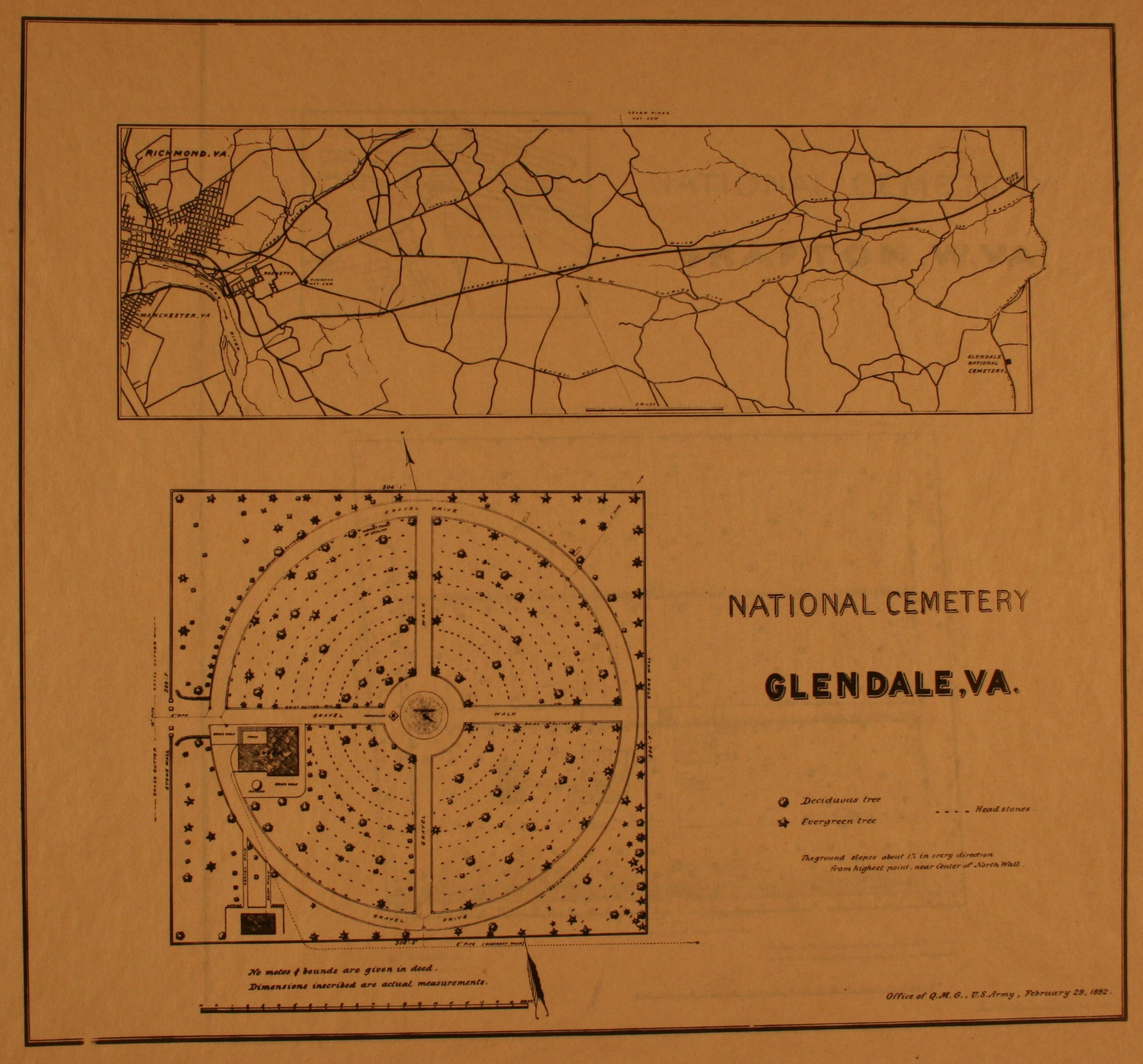
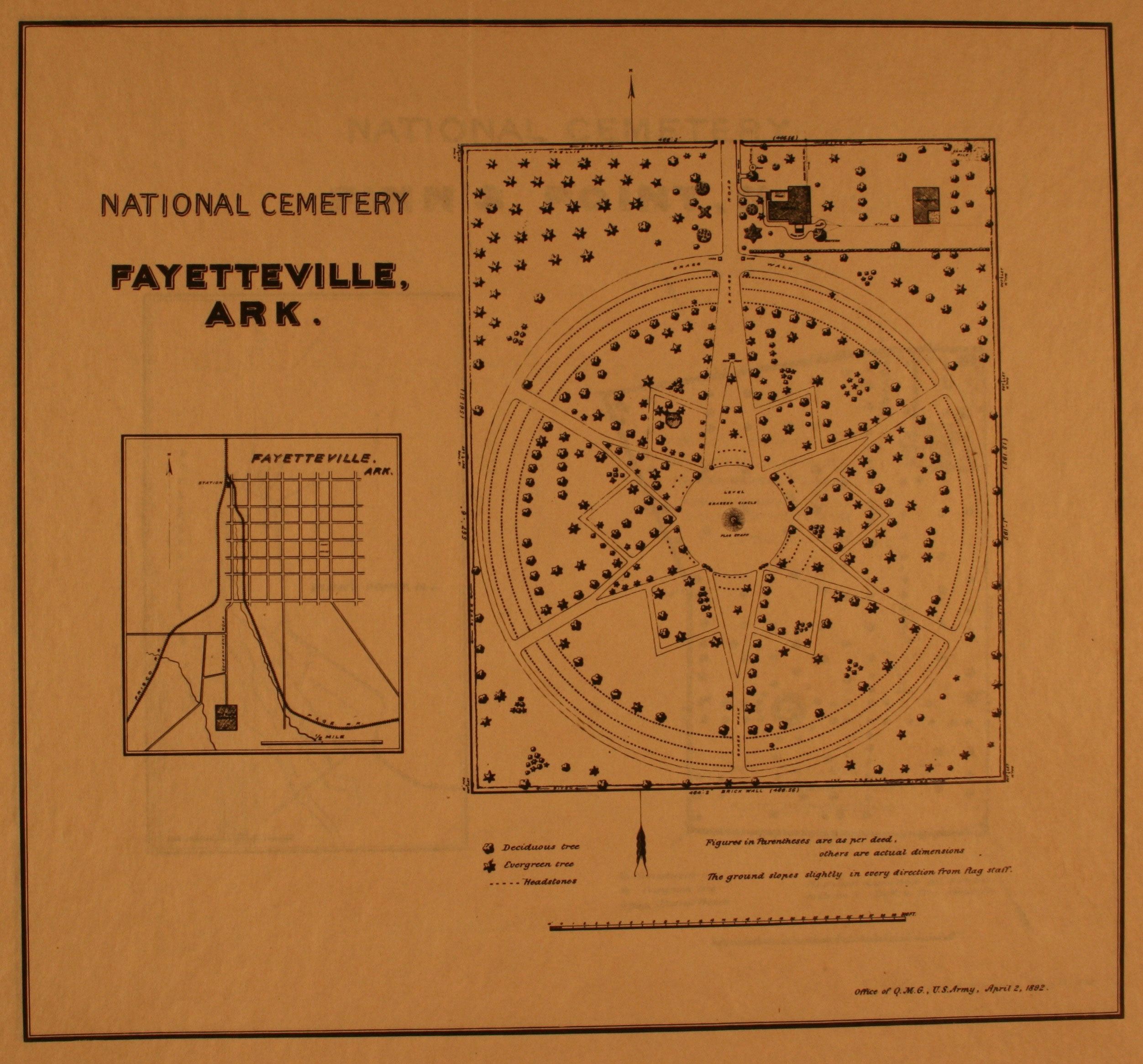
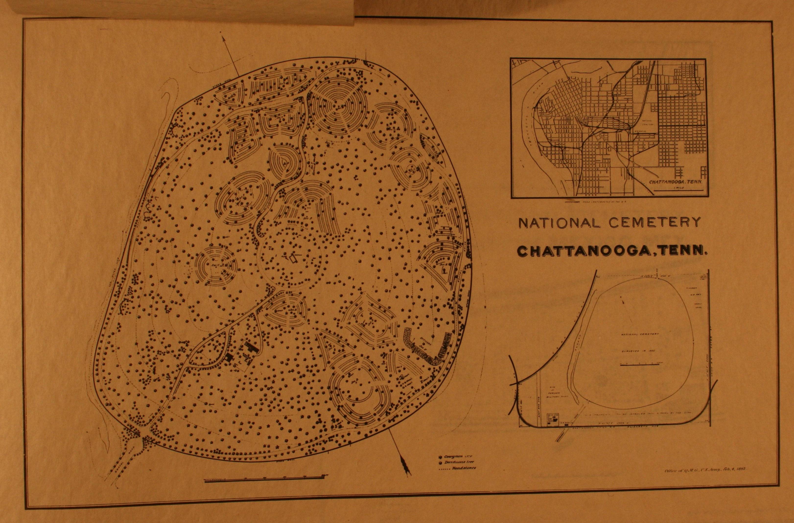
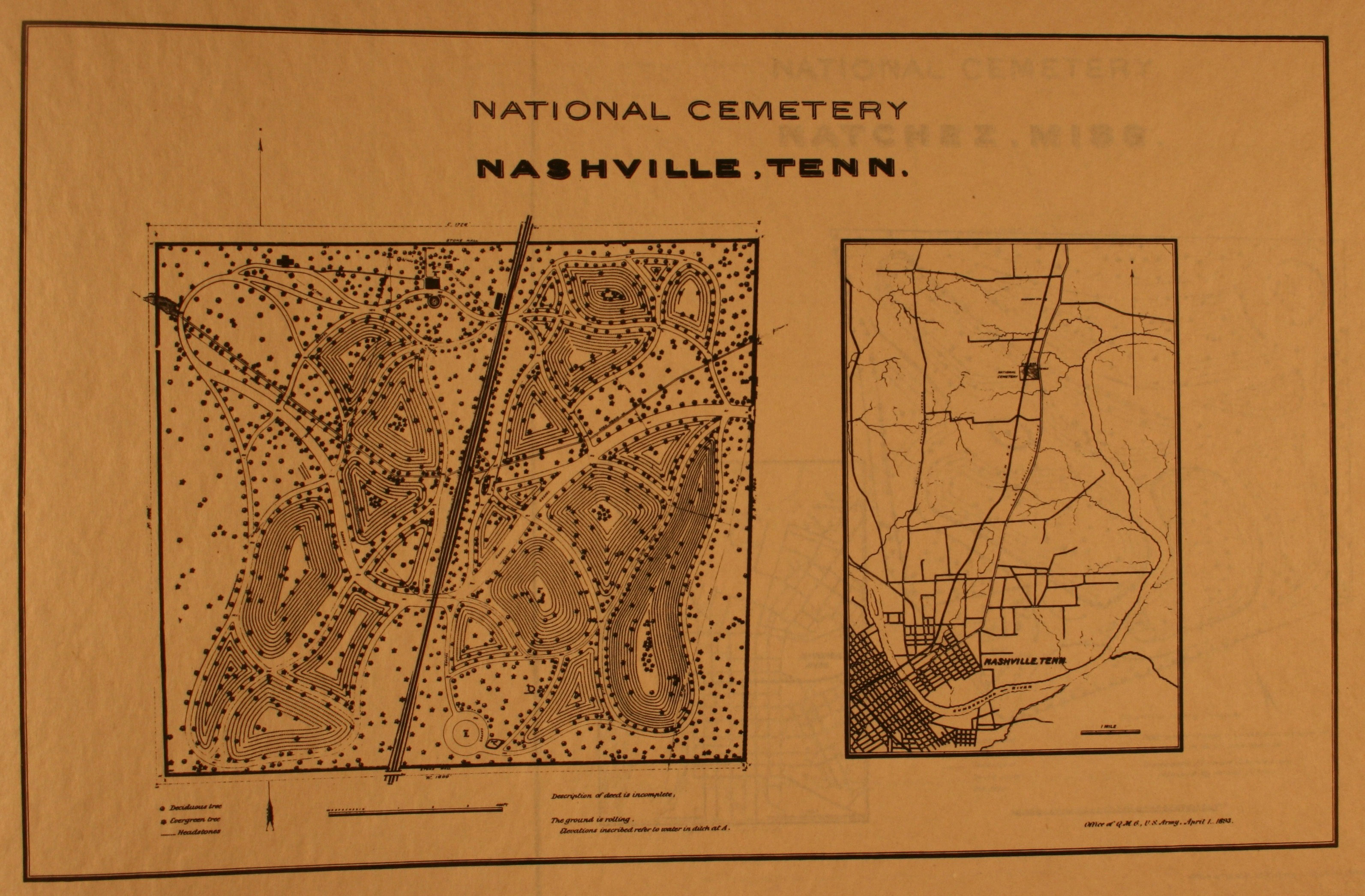
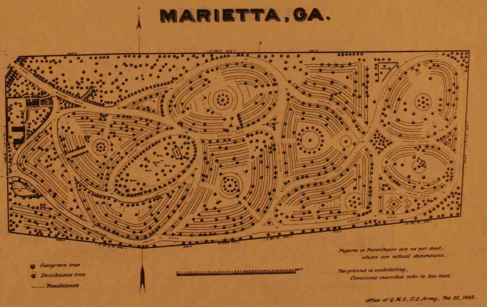
Natchez National Cemetery dates to 1866, one of 21 national cemeteries established in that year. Located on a bluff overlooking the Mississippi River, the site’s topography influenced its unique layout of irregular shaped burial sections, terraced hillsides, and gravel and grass pathways.
Natchez’s position on high bluffs above the Mississippi River contributed to its role as an important port and economic center. Both before and after the Civil War, cotton flowed through Natchez’s wharfs and docks, bound for destinations upriver and south to New Orleans. In May 1862, shortly after the Union capture of New Orleans and Baton Rouge, Natchez surrendered. Held by the Union for the duration of the war, the city escaped the damage and devastation seen by many other southern ports.
In 1866, the U.S. government purchased 11 acres for use as a national cemetery. The site chosen lay two miles north of the city center and adjacent to the Natchez City Cemetery, which dates to 1822. The site is irregular in shape—five uneven sides—and is enclosed by a brick wall built in 1873. Due to the steep topography, the cemetery features terraced burial sections of various shapes and sizes.
Original interments in the Natchez National Cemetery included Union soldiers who died while under care at a nearby military hospital. The U.S. government transferred remains of soldiers buried in and near Vidalia, Louisiana (across the Mississippi River from Natchez) and numerous other sites within a 50-mile radius of Natchez. By 1871, the cemetery held the remains of 3,086 Union men, with only 253 identified.
The cemetery’s entrance at the property’s southern corner is guarded by a double-wrought iron gate, constructed in 1932. Just inside the cemetery’s entrance stands the cemetery’s lodge. Built in 1931, the one-story Colonial Revival house once served as the residence for the cemetery’s superintendent. Today, the lodge is used as an administrative office.
Two other cemetery structures were built in 1931; a brick and concrete maintenance building is located on the eastern edge of the cemetery, and the cemetery’s rostrum, used as a speaking platform, stands just north of the lodge.
Two Buffalo soldiers, members of the African American 24th U.S. Infantry regiments, are interred in the cemetery, as are members of the 58th U.S. Colored Infantry. Many of the burials in Section D of the cemetery are Union Navy personnel, who were reinterred from other burial places in the Natchez vicinity. The sailors served on some of the most decorated Union vessels, including Admiral David Farragut’s flagship USS Hartford and the river monitors Osage and Ozark.
Natchez National Cemetery is also the final resting place of a recipient of the Medal of Honor, the nation’s highest military decoration, given for “conspicuous gallantry and intrepidity at the risk of his life above and beyond the call of duty.”
Natchez National Cemetery is located at 41 Cemetery Rd. in Natchez, MS. The cemetery is open for visitation daily from 8:00am to sunset. The administrative office is open Monday-Friday from 8:00am to 4:30pm; it is closed on all Federal holidays except for Memorial Day and Veterans Day. For more information please contact the cemetery office at 601-445-4981, or see the Department of Veterans Affairs website. While visiting, be mindful that our national cemeteries are hallowed ground. Be respectful to all of our nation’s fallen soldiers and their families. Additional cemetery policies may be posted on site.
The Natchez National Historical Park is a National Park Service unit that shares Natchez’s history through two distinctive residences; Melrose, the antebellum plantation estate of John T. McMurran, and the downtown home of William Johnson, a free African American barber and diarist.
Natchez National Cemetery was photographed to the standards established by the National Park Service’s Historic American Landscapes Survey.
Vicksburg National Cemetery in Vicksburg, Mississippi contains the remains of more than 17,000 Union soldiers, the most of any national cemetery in the country. Vicksburg National Cemetery is one of 14 national cemeteries managed by the National Park Service and is part of the Vicksburg National Military Park. The site interprets the siege and capture of Vicksburg by Union forces in 1863 through the cemetery, museums, and driving and walking routes along Vicksburg’s Confederate defenses. Established in 1866, the cemetery serves as a final resting place for Union men who fought in the campaign and siege of Vicksburg.
Early in the Civil War, Union military strategists recognized the importance of controlling the Mississippi River, a vital transportation corridor. The Confederacy moved both men and supplies along the Mississippi River. Union control of the river would not only deprive the Confederacy of a main artery, but would also divide the southern states in half. By June 1862, Union Army and Naval forces captured many forts and cities along the river. However, Vicksburg remained in Confederate hands. Sited on high, steep bluffs 200 feet above the river and heavily defended by forts and earthworks, the city successfully fended off numerous attacks in 1862.
In spring 1863, Union General Ulysses S. Grant launched a new attempt to capture Vicksburg. After capturing the Mississippi capital of Jackson, he marched his force of 45,000 soldiers west to Vicksburg. After an initial bloody attack against the heavily fortified city, Grant surrounded the city and laid siege in late May 1863. Although surrounded by a powerful army and without access to food, weapons, and ammunition, Vicksburg’s Confederate soldiers and civilians refused to surrender.
Grant’s forces built their own network of earthworks and trenches running parallel to the Confederate defensive line. Union artillery cannons pummeled the defenses, and Union gunboats on the river fired into the city. The lack of food, compounded by malaria and other illnesses, took a heavy toll on the Confederate force in Vicksburg. On July 4, 1863 after a 47-day siege, the Confederate force surrendered to Grant. Five days later, Union forces captured Port Hudson, Louisiana, the last Confederate stronghold on the Mississippi River.
Vicksburg National Cemetery was established in 1866 as a resting place for the remains of Union soldiers who died in the assaults and subsequent siege of the city. The cemetery is at the western edge of the city’s defensive line, on a bluff overlooking the Mississippi River. The rugged landscape required the construction of terraces and the planting of trees to prevent erosion and influenced the irregular layout of the 116-acre cemetery. A low brick wall, constructed prior to 1893, encloses the cemetery.
The cemetery’s main entrance is located inside the National Military Park near the USS Cairo Museum. Elaborate ornamental iron gates stand at the entrance. Just inside the entrance is the cemetery's superintendent’s lodge. Built in 1928, the two-story lodge features a gambrel roof with shed dormers, evocative of the Dutch Colonial style popular of the time.
As originally designed, the cemetery’s main entrance was on the southwestern edge of the property along what is now N. Washington St. The gate at this original entrance still stands. Built in 1880 of Alatawa limestone, the 36-foot-tall gate is patterned after a triumphal arch. Two 17-foot-tall solid stone columns are connected by an arch and crowned with an entablature and attic story. The attic story features the inscription, “Here Rest In Peace 16,600 Citizens Who Died For Their Country In the Years 1861-1865.”
More than 17,000 Union soldiers are buried at the cemetery, and almost 13,000 are unknown. In addition to those who fell at Vicksburg, the remains of Union soldiers from nearby locations in Mississippi, Arkansas, and Louisiana were reinterred in the national cemetery. The highest ranked known interment from the Civil War period is General Embury Osband, who served as the recruiter for the First Mississippi Colored Calvary. Roughly 1,300 graves are occupied by veterans of later conflicts, including the Spanish-American War, World Wars I and II, and the Korean War.
In 1899, the Confederate defensive line and the Union siege line around Vicksburg were established as the Vicksburg National Military Park. The park is the eighth oldest national park in the country. During the 1900s, veterans' groups and other organizations erected numerous monuments and statues dedicated to the regiments that fought at Vicksburg. Today, the site is considered one of the most important collections of monuments in the United States with more than 1,330 monuments, markers, tablets, and plaques. Managed by the National Park Service, the National Military Park features a visitors center, a museum for a preserved Civil War ironclad Cairo, and driving and walking routes.
The entrance to the Vicksburg National Military Park, which includes the Vicksburg National Cemetery, is located in the 3200 block of Clay St. in Vicksburg, MS. The park and cemetery are open for visitation daily from 8:00am to 5:00pm, and until 7:00pm from April through September. The park’s visitor center is open for visitation daily from 8:00am to 5:00pm. The Military Park is closed on Thanksgiving, Christmas Day, and New Year’s Day. For more information visit the National Park Service's Vicksburg National Military Park website or call the park’s visitors center at 601-636-0583. While visiting, be mindful that our national cemeteries are hallowed ground and be respectful to all of our nation’s fallen soldiers and their families. Additional cemetery policies may be posted on site.
The Vicksburg National Cemetery is part of the Vicksburg National Military Park, a National Park Service unit that commemorates the campaign, siege, and defense of Vicksburg. A 16-mile tour road runs through the 1,800-acre park along Union siege and Confederate defensive lines. The visitor center features films and exhibits on the battle for Vicksburg. Located near the national cemetery, the USS Cairo Museum holds a Union ironclad sunk in 1862 and recovered in 1964. Outside of the main park site, three detached park units preserve and interpret the Confederate riverfront batteries along the Mississippi River. Pemberton’s Headquarters, in downtown Vicksburg, commemorates the headquarters of Confederate commander John Pemberton.
The National Park Service’s American Battlefield Protection Program provides a summary of the siege and defense of Vicksburg. The history and culture pages on the National Military Park’s website provides detailed accounts of General Ulysses S. Grant’s campaign to capture Vicksburg and bring the Mississippi River under Union control.
MISSOURI
Jefferson Barracks National Cemetery
Jefferson Barracks National Cemetery, consisting of more than 310 acres, is located south of St. Louis on the site of a former military post. Established in 1826, Jefferson Barracks was the first permanent military installation west of the Mississippi, and was a critical training and medical facility during the Civil War. The national cemetery was officially established in 1866, although the site had been used as a post cemetery since the founding of Jefferson Barracks. The U.S. Government deactivated the military post in 1946, but the national cemetery has continued operation and is today one of the largest in the United States. Jefferson Barracks contains burials from all major United States conflicts, from the Revolutionary War to the present. The cemetery’s grounds feature a number of historic and modern monuments dedicated to veterans.
Strategically located along the Mississippi River at the eastern edge of the lands of the Louisiana Purchase territory, the U.S. Army initially established Jefferson Barracks in 1826 as both a supply center and a troop training and staging facility. Thomas Jefferson died shortly after the military selected the site on the Mississippi River bluffs and the post was named in his honor. The barracks has housed a number of famous military men, including Ulysses S. Grant, Jefferson Davis, and Robert E. Lee.
In March 1863, the U.S. Army officially established the Jefferson Barracks Post Cemetery, a ten-acre burial ground incorporating an older cemetery constructed by soldiers in 1826. The first recorded burial was that of Elizabeth Ann Lash, an infant daughter of an officer stationed at the barracks.
In 1866, authorized by congressional resolution, the Secretary of War designated the post cemetery as a national cemetery. The cemetery grew rapidly after the Civil War as remains from isolated burial grounds throughout the region were reinterred at Jefferson Barracks. By 1869, more than 10,000 deceased Union soldiers had been transferred to the national cemetery. In 1876, 470 unknown Union remains were transferred from Arsenal Island in Illinois, the U.S. Army’s contagious disease hospital located on an island in the Mississippi River, known during the war as “Smallpox Island." Flooding washed away the cemetery’s wooden markers, making identification of the remains impossible when they were reinterred.
In the early 1890s, the national cemetery expanded, more than doubling in size. In 1922, an Executive Order transferred land and a newly constructed medical center for World War I veterans at Jefferson Barracks from the Army to the Veterans Bureau, the precursor to the Department of Veterans Affairs. This transfer also included the 170-acre national cemetery.
After World War II, the national cemetery expanded with a transfer of more than 150 acres from the military post. Jefferson Barracks National Cemetery became a central location for group interments, and today has more than 560 group burials. Notable group burials include 123 victims of a 1944 massacre, all killed while held as prisoners of war by the Japanese in the Philippines, and 41 unidentified Marines killed when their helicopter crashed in South Vietnam in 1968.
One of the older monuments at Jefferson Barracks National Cemetery is dedicated to 175 soldiers of the 56th U.S. Colored Infantry. A stone obelisk, dating from the late 1860s, honors the men who died during a cholera outbreak in 1866. Originally the monument and the soldiers’ remains were located at the Koch Quarantine Hospital in St. Louis. They were relocated to Jefferson Barracks National Cemetery in 1939.
Among the burials at Jefferson Barracks are those from Fort Bellefontaine, which was active between 1806 to 1826, when Jefferson Barracks was established at the site of the fort. The St. Louis chapter of the Daughters of the American Revolution donated a red granite boulder to commemorate the officers and soldiers who died at Fort Bellefontaine and were buried in its cemetery.
The Minnesota Monument, dedicated in May 1922, is one of several erected in national cemeteries by that state to honor Minnesotans who died during the Civil War. John K. Daniels, a noted sculptor from St. Paul, was commissioned to design the five monuments. He sculpted both a female figure holding a wreath and a soldier in a great coat with hands resting on the butt of a rifle, barrel pointing downward. The monument at Jefferson Barracks features only the female figure and honors the 164 Minnesotan officers and soldiers buried at the national cemetery.
A 19th century monument that stands nearly four feet tall honors the unknown soldiers of the Civil War. The Daughters of Union Veterans of the Civil War erected this granite monument in 1940.
Since the 1950s, other monuments honoring Civil War dead have been dedicated at the cemetery, including a memorial to the Confederate dead in 1988. The cemetery also features monuments dedicated to those who served in World War II, the Korean War, the Vietnam War, and the Gulf War.
Jefferson Barracks National Cemetery is the final resting place for eight recipients of the Medal of Honor, the nation's highest military decoration, given for "conspicuous gallantry and intrepidity at the risk of his life above and beyond the call of duty." The remains of three Revolutionary War veterans are also interred in the cemetery's Old Post Section. These interments, which include Major Russell Bissell, the commanding officer of Fort Bellefontaine at the time of his death in 1807, were transferred to Jefferson Barracks in the 1900s.
Another notable burial at the cemetery is U.S. Air Force Lieutenant Michael Blassie. Blassie died in 1972 when his plane was shot down over South Vietnam. His remains were initially placed in the Tomb of the Unknowns at Arlington National Cemetery outside of Washington, D.C. Blassie’s family had DNA tests conducted to confirm his identity, and requested his remains be transferred to Jefferson Barracks National Cemetery.
Although officially established in 1866, the cemetery contains no structures that date to its early period. A 19th century superintendent’s lodge and tool shed stood in the cemetery’s Old Post Section until 2004. Today, a permanent committal shelter now stands at the site of the former lodge and shed.
Jefferson Barracks National Cemetery is located at 2900 Sheridan Rd. in the Green Park area of St. Louis County, MO. The cemetery is open for visitation daily from dawn to dusk; the administrative offices are open Monday-Friday from 8:00am to 4:30pm, and are closed on Thanksgiving, Christmas, and New Year’s Day. For more information, please contact the cemetery offices at 314-845-8320, or see the Department of Veterans Affairs website. While visiting, please be mindful that our national cemeteries are hallowed ground. Be respectful to all of our nation’s fallen soldiers and their families. Additional cemetery policies may be posted on site.
Jefferson Barracks National Cemetery was photographed to the standards established by the National Park Service’s Historic American Landscapes Survey. The former superintendent’s lodge, the tool shed, and various memorials at Jefferson Barracks National Cemetery have been documented by the National Park Service’s Historic American Buildings Survey.
Located a quarter-mile southeast of the state capitol building, the Jefferson City National Cemetery was established in 1867 as a burial place for Union soldiers who died in the area. While the city saw little military action in the war, the Union maintained a strong force in the city, whose residents were sympathetic to the secessionist cause. Jefferson City National Cemetery retains many of its original features, including its superintendent’s lodge.
As the drums of discontent began beating before the Civil War, Jefferson City was a town torn between the North and the South. In May 1861, Jefferson City residents took to the streets around the state capitol, demanding secession from the Union. An influx of Federal troops determined to keep Missouri in the Union negated residents’ calls for secession. Given the public’s sentiments, the Union held Jefferson City under martial law until 1865.
The Jefferson City National Cemetery features a rectangular layout that has changed little since the 1860s. Union troop burials at the cemetery occurred as early as 1861, long before its official establishment as a national cemetery in 1867. The grounds are surrounded by an ashlar stone wall, which replaced the original wooden fence in 1871. Today, the stone wall still stands along three sides of the cemetery. On the fourth side, by the main entrance at McCarty Street, a wrought-iron fence replaced the stone wall in 1937. The entrance is flanked by limestone pillars supporting large iron gates.
Beyond the entrance gate, a central drive extends through the length of the grounds, ending at a rostrum at the southern end of the cemetery. Constructed in 1942, the rostrum’s design is similar to others built during this period by the Federal Government. Resembling a Greek temple, the limestone rostrum features Doric columns at the front elevation and three Roman arches at the rear. A limestone parapet wall crowns the top of the structure.
Just inside the main gate is the superintendent’s lodge, a one-and-one-half story brick building of the Second Empire style. The lodge’s design follows the standard plan issued by U.S. Army Quartermaster General Montgomery C. Meigs. The lodge is one of the 17 remaining Second Empire-style Meigs lodges found at Civil War-era national cemeteries. Built in 1870, the L-shaped building was constructed of ashlar stone and features stone quoins on the corner of the building. Typical of Second Empire architecture, the lodge is topped by a Mansard roof covered in hexagonal slate tiles of varying colors. In 1931, a one-story kitchen addition was built at the rear of the lodge. In 1937, an ashlar limestone, two-story utility building was constructed to the left of the lodge, which contains storage space and public restrooms. The cemetery’s flagpole, along the main drive near the lodge, dates from 1926.
Between burial sections 7 and 9, a monument dedicated to the 108 members of the Missouri Volunteer Infantry killed in 1864 in an unsuccessful Union attack in Centralia, Missouri was constructed. Originally, 78 of the dead were buried in a trench grave in Centralia. In 1873, their remains were reinterred at Jefferson City National Cemetery. The monument, a limestone obelisk, bears the name of each of the 108 volunteers killed, including their commander Major A.V.E. Johnson.
A notable burial at the Jefferson City National Cemetery is Logan Bennett, one of the original founders of the city’s Lincoln University, a historically black college established by men of the 62nd and 65th U.S. Colored Infantries. The soldiers raised funds to create a university to benefit newly free African Americans, and modeled the institution after Booker T. Washington’s Tuskegee Institute. Bennett and his wife are buried in section 8.
Jefferson City National Cemetery is located at 1024 East McCarty St. in Jefferson City. The cemetery is open for visitation daily from dawn to dusk. No cemetery staff is present onsite. The administrative office is located at the Jefferson Barracks National Cemetery, in St. Louis, Missouri, and the offices are open Monday-Friday from 8:00am to 4:30pm; the offices are closed on Thanksgiving, Christmas, and New Year’s Day. For more information, please contact the cemetery offices at 314-845-8320, or see the Department of Veterans Affairs website. While visiting, please be mindful that our national cemeteries are hallowed ground. Be respectful to all of our nation’s fallen soldiers and their families. Additional cemetery policies may be posted on site.
Jefferson City National Cemetery was photographed to the standards established by the National Park Service’s Historic American Landscapes Survey.
Springfield National Cemetery was established in 1867 on prairie land south of Springfield, Missouri. Today, the cemetery’s 18 acres are bounded by residential neighborhoods and commercial areas. Initially created as a final resting place for Union soldiers who died in battle near Springfield, the cemetery now contains the remains of veterans from other wars, including the Revolutionary War, Spanish-American War, and World War II. The Springfield National Cemetery also includes a six-acre portion established by the Confederate Cemetery Association in 1871. An act of Congress in 1911 authorized the Secretary of War to accept the Confederate cemetery as a part of the Springfield National Cemetery.
Springfield, Missouri, lies on the Springfield Plateau of the Ozark Mountains, which gives the city its nickname, "Gateway of the Ozarks." First settled in 1829 by John Polk Campbell, the area quickly became an established settlement with stores, mills, and a post office, and was incorporated as a town in 1838.
Although Missouri voted to stay in the Union, Confederate sympathies ran strong throughout the state. On August 10, 1861, the first major Civil War engagement west of the Mississippi River occurred ten miles south of Springfield. More than 5,000 Union troops and 12,000 Confederate forces clashed at Wilson’s Creek. The battle ended in a Confederate victory, but disorganization and bad planning prevented Southern forces from capitalizing on their success. The battle is significant, marking the first death of a Union General in combat; Brigadier General Nathaniel Lyon died during a Union charge, felled by a Confederate bullet.
After the Civil War, the city of Springfield purchased 80 acres of prairie for a cemetery, and granted the U.S. government the privilege of selecting a plot for a national cemetery. Five acres were selected on the highest ground and purchased for $37.50 an acre. The Springfield National Cemetery was officially established in 1867, and many of the men who died in the Battle of Wilson’s Creek were buried there. Additionally, the remains of Union troops buried in several Missouri counties were removed and reinterred in the new cemetery.
In 1871, a Confederate cemetery was established adjacent to the national cemetery, containing roughly six acres total with an area of 2.7 acres enclosed by a wall. In March 1911, Congress authorized the Secretary of War to accept the Confederate cemetery as part of the Springfield National Cemetery. A deed restriction prevented the burial of anyone other than Confederate military veterans within the boundaries of the old Confederate cemetery.
After World War II, the Department of the Army expanded the national cemetery, receiving approval from the Confederate Cemetery Association to use areas within the boundaries of the old Confederate cemetery but outside the enclosed area. In the 1980s, given the many unoccupied graves within the area restricted for Confederate burials, the Department of Veterans Affairs and the Confederate Cemetery Association of Missouri agreed to allow burials of all veterans in the area within the enclosure wall. In 1984, the Daughters of the Confederacy dedicated a plaque on a monument in the old Confederate section, stating that the area’s “use by all veterans and their dependents serves as a symbol of unification of purpose for memorializing those who have honorably served this great nation….”
The national cemetery’s original five acres were laid out in a square pattern, with evenly spaced paths crossing perpendicularly and diagonally. A limestone wall, capped with sandstone slabs, lines the perimeter of the original grounds. The wall, constructed in 1874, replaced a wooden picket fence. At the center of the original grounds is a circle with a flagpole and four artillery monuments. Immediately west of the front entrance gate stands the cemetery’s administration building, a two-story brick structure with a slate hipped roof. Built in 1940, the brick building served as a home and office for the cemetery’s superintendent. Renovated in 1996, the building today is used solely for administrative purposes. At the northwest corner of the original cemetery grounds stands a brick service building constructed prior to 1933; it has been extensively modified since it was built.
Also located on the grounds of the cemetery is a rectangular stone-block rostrum. Built between the Confederate and Union portions of the cemetery, the rostrum resembles a miniature Greek temple and features speakers’ lecterns on both sides for patriotic and memorial observances. Bronze plaques on the rostrum’s south side face toward the Confederate graves. One plaque references the Confederate soldiers buried there and the battles in which they died, notably the Battle of Wilson’s Creek. The other plaques state the establishment dates of the Confederate cemetery and the installation of the cemetery’s carillon in 1979. On the rostrum’s north side, facing Union graves, a single plaque is inscribed with a memorial to the veterans of the Vietnam War.
Several large commemorative monuments stand on the cemetery’s grounds. Two are located just east of the administration building. The oldest is a memorial honoring Brigadier General Nathaniel Lyon, the commanding officer at the Battle of Wilson’s Creek and the first Union General to die in the Civil War. The 12-foot-tall monument, erected in 1888 by the citizens of Springfield, is a marble pillar topped with a knight’s helmet, battle axe, and wreath. Nearby the Lyon monument, a Union memorial stands 25-feet tall. Erected in 1907 in accordance with the bequest of local doctor T.J. Bailey, it features a life-sized statue of an infantry soldier and is inscribed with a commemoration honoring the Union dead. The other side of the monument has an inscription stating that the monument was “erected under the provisions of the last will of Dr. Thomas Bailey to show his love for the Union and its gallant defenders”
Commissioned by the United Confederate Veterans of Missouri in 1901, Italian sculptor Chevalier Trentanove created a bronze figure of a Confederate soldier to honor both the Confederate soldiers of Missouri and General Sterling Price, a former governor of Missouri and the Confederate commander at the Battle of Wilson’s Creek. The front of the monument features a bronze bas-relief portrait of Price. Also located within the old Confederate cemetery grounds is a granite marker, placed in 1958 by the Daughters of the Confederacy, honoring the unknown Confederate dead at the Battle of Wilson’s Creek.
Erected in recent years, other monuments at the Springfield National Cemetery include a granite and bronze memorial to those who died in the attack on Pearl Harbor in 1941. The Pearl Harbor Survivors Association dedicated the memorial in 1992. In 1999, the Sons and Daughters of the American Revolution installed a granite monument in honor of those who died in the Revolutionary War. A Revolutionary War veteran, Private William Freeman, is buried at Springfield National Cemetery. Freeman was a North Carolina militia member who served as a scout for General George Washington. Freeman’s grave is located near the General Lyon Memorial.
Other notable burials in the Springfield National Cemetery include five Buffalo Soldiers. Members of African American army regiments created after the Civil War, the "Buffalo Soldiers" protected settlers moving west, built and renovated Army posts and camps, and maintained law and order in the western expanses of the country.Springfield National Cemetery is also the final resting place of five recipients of the Medal of Honor, the nation's highest military decoration, given for "conspicuous gallantry and intrepidity at the risk of his life above and beyond the call of duty."
Springfield National Cemetery is located at 1702 East Seminole St. in Springfield, MO. The cemetery is open for visitation daily from dawn to dusk; however, limited cemetery staff are present on site. Springfield National Cemetery is overseen by the administrative office at Jefferson Barracks National Cemetery in St. Louis, MO, It is open Monday-Friday from 8:00am to 4:30pm, and is closed on Christmas and New Year’s Day. For more information, please contact the cemetery office at 314-845-8320, or see the Department of Veterans Affairs website. While visiting, please be mindful that our national cemeteries are hallowed ground. Be respectful to all of our nation’s fallen soldiers and their families. Additional cemetery policies may be posted on site.Located near the cemetery is the site of the Battle of Wilson’s Creek, the first major battle of the Civil War fought west of the Mississippi River. Now a national battlefield managed by the National Park Service, the site includes a museum and paths for hiking, driving and cycling.
Springfield National Cemetery was photographed to the standards established by the National Park Service’s Historic American Landscapes Survey.
Somewhere among the 27 acres of Kansas City’s Union Cemetery lie the remains of 15 Confederate soldiers. The men died while held as prisoners of war in Kansas City after the Battle of Westport. Although their gravesites are unknown, the U.S. government erected a granite obelisk to commemorate the soldiers in 1911. Numerous veterans from the Revolutionary War to the Vietnam War are also buried in the cemetery, as are many prominent 19th century Kansas City residents. In 1849, a cholera epidemic hit the Missouri towns of Westport and Kansas (now Kansas City). With the towns’ respective cemeteries near capacity, they decided to form a “union” and establish a new cemetery between the municipalities. The Missouri state legislature authorized a corporation, which eventually selected a 49-acre site between the two towns for Union Cemetery.
Westport, located south of Kansas City, became an important disembarkation point for travelers heading west along the Santa Fe, Oregon, and California trails. Its location and trail status also made the town a target during the Civil War. Because Missouri was a border state, the Confederacy considered the capture of Missouri a critical goal. In October 1864, Confederate forces raided several towns in Kansas and Missouri. Confederate and Union forces met in Westport on October 23, 1864. More than 30,000 soldiers and cavalrymen fought in the battle, making it one of the largest confrontations west of the Mississippi River. Union troops forced the Confederate raiders into retreat, preventing Confederate control over Missouri.
In 1897, Kansas City annexed Westport. By the early 20th century, conditions in Union Cemetery declined, forcing the cemetery’s management association to sell off 18 undeveloped acres of the property. In 1937, the association transferred ownership to the municipal government of Kansas City. Today, the Kansas City Parks and Recreation Department manages the cemetery.
In 1911, the U.S. government erected a 15-foot-tall granite obelisk as a memorial to 15 Confederate prisoners of war buried in Union Cemetery. Union troops captured the soldiers during the Battle of Westport. Originally buried in another city cemetery, the remains were later reinterred in Union Cemetery. However, the exact location of the gravesites was lost. Because individual grave markers could not be erected, the obelisk to the 15 men was installed on the cemetery’s grounds. The dedication ceremony on October 22, 1911, featured an invocation by a local reverend and a speech by the Kansas City mayor. The bronze panels on the obelisk carry inscriptions that list the soldiers and explain the unknown whereabouts of their graves.
Many prominent Kansas City residents were also interred at Union Cemetery, including veterans from the War of 1812 and later conflicts. Civil War veteran and Missouri artist George Caleb Bingham is interred in the eastern section of the cemetery.
Union Cemetery Monument Site is located at 227 E. 28th Terrace in Kansas City, MO, within Union Cemetery. Leavenworth National Cemetery oversees the monument site; its administrative office is open Monday-Friday from 8:00am to 4:30pm. The office; it is closed on all Federal holidays except for Memorial Day. For more information about the monument site, please contact the Leavenworth National Cemetery office at 913-758-4105, or see the Department of Veterans Affairs website.Union Cemetery is open for visitation daily from sunrise to sunset. The Union Cemetery Historical Society is a nonprofit association working with the Kansas City government to collect data about the cemetery and those buried on the property. The society’s records and files are open to the public and available in the sexton’s cottage. While visiting, be mindful that our national cemeteries and Confederate cemeteries and monument sites are hallowed ground, and be respectful to all of our nation’s fallen soldiers and their families. Additional cemetery policies may be posted on site.
The Freedom’s Frontier National Heritage Area encompasses 41 counties in eastern Kansas and western Missouri along the Kansas-Missouri border. Before and during the Civil War, this region became a crucible of conflict between pro-slavery forces in Missouri and those who sought to keep Kansas as a free state. The national heritage area works with public and private partners to interpret and share the story of “Bleeding Kansas” and the continuing stories of the struggles for freedom of other groups, including American Indians and women.
Union Cemetery Monument Site was photographed to the standards established by the National Park Service’s Historic American Landscape Survey.
NEBRASKA
Fort McPherson National Cemetery
Located on a gently rolling landscape of 20 acres, the Fort McPherson National Cemetery is the only national cemetery in the state of Nebraska. The cemetery evolved from the post cemetery of Fort McPherson, a U.S. Army facility established to protect settlers moving west to Colorado. The military abandoned the fort in 1880, although they retained a large tract that was dedicated as a national cemetery in 1873. Today, the cemetery is the final resting place for soldiers who fought in the Indian Wars, the Civil War, World Wars I and II, and more recent conflicts.
In October 1863, the U.S. government established a fort near Cottonwood Canyon, roughly five miles south of present-day Maxwell, Nebraska. Soldiers stationed at this strategic location near the Platte River and the Overland Trail protected settlers moving westward to Colorado and provided security for the construction of the railroad. Originally named Fort McKean, the fort had its name changed to Fort McPherson in 1866 to honor Union General James McPherson, who died during the 1864 Battle of Atlanta.
In 1873, a national cemetery was established at the site of the fort. The initial purpose of the cemetery was to provide an appropriate burial ground for remains of soldiers at remote, abandoned posts on the western frontier. The military transferred remains from post cemeteries in Wyoming, Colorado, South Dakota, and Nebraska. Early interments also included the remains of six men from Company F, 3rd U.S. Calvary. The soldiers died in May 1873, when a flash flood swept through their campsite in the Republican River Valley.
As conflicts with Indian groups dissipated in the late 1870s, so did the need for a military presence in the area. The U.S. military abandoned the fort in 1880, selling the fort’s buildings at local auction but retaining the national cemetery property. The cemetery today contains more than 3,700 interments. The cemetery is roughly square in shape, with a central drive bisecting the property. Avenues within the cemetery form rectangular burial sections, providing a rigid formality for the placement of graves and grave markers.
The cemetery is enclosed by wrought-iron fencing with large vehicular gates supported by stone piers, all constructed in 1941. Just inside the main gate is the cemetery’s oldest building, the superintendent’s lodge. The 1876 lodge is a one-and-a-half story brick structure designed in the Second Empire style, identifiable by its mansard roof and dormer windows. The lodge’s design is of the standard plan created by Quartermaster General Montgomery C. Meigs, and it is one of the 17 remaining Second Empire-style Meigs lodges found at the Civil War-era national cemeteries. Several other buildings at the cemetery, including the committal shelter, public information building, and utility structures, date from the 1990s.
A white marble monument marks the mass grave of 28 soldiers killed in an 1854 encounter with the Sioux at Fort Laramie in the Wyoming Territory. Commonly referred to as the Grattan Massacre, the incident is considered the starting point of hostilities between the United States and the Sioux Nation. The hostilities ended in 1890 with the massacre at Wounded Knee, South Dakota.
Fort McPherson National Cemetery is the final resting place for four recipients of the Medal of Honor, the nation’s highest military decoration, given for “conspicuous gallantry and intrepidity at the risk of his life above and beyond the call of duty.”
Other significant interments include 63 Buffalo soldiers from the 9th and 10th U.S. Cavalry. These African American soldiers served in the West during the Indian Wars after the Civil War. The soldiers, originally interred at Fort Robinson, Nebraska, were transferred to Fort McPherson National Cemetery in 1947 when the fort was deactivated.
Fort McPherson National Cemetery is located at 12004 S Spur 56A, roughly four miles south of Maxwell, NE. The cemetery is open for visitation daily from dawn to dusk; the administrative office is open Monday-Friday from 8:00am to 4:30pm, and is closed on all Federal holidays except for Memorial Day. For more information, please contact the cemetery office at 308-582-4433, or see the Department of Veterans Affairs website. While visiting, please be mindful that our national cemeteries are hallowed ground. Be respectful to all of our nation’s fallen soldiers and their families. Additional cemetery policies may be posted on site.
McPherson National Cemetery was photographed to the standards established by the National Park Service’s Historic American Landscapes Survey.
NEW JERSEY
Beverly National Cemetery
During the Civil War, numerous Pennsylvania and New Jersey towns that lined the Delaware River provided support services for the Union. Several military hospitals cared for wounded troops. Soldiers not well enough to return to active duty, but not needing intensive medical care, stayed at Beverly's convalescent hospital. In 1864, the U.S. government purchased a small one-acre plot to bury those who died at the hospital. From 1936 through 1951, the cemetery expanded and now totals 64 acres. Interments number more than 40,000, and include veterans from the Revolutionary War, Civil War, World War II, and the Vietnam War.
In 1864, at the height of the Civil War, wounded soldiers crowded Philadelphia’s military hospitals. To make room for more critically injured patients, a convalescent hospital was established in Beverly, New Jersey, 20 miles north of Philadelphia on the east bank of the Delaware River. The War Department converted a rope factory in to a facility to care for soldiers well enough not to need full hospital care yet not fit to return to active duty.
The river steamer John A. Warner transported soldiers from Philadelphia to Beverly’s hospital. The steamer sounded its whistle in advance of its arrival at the town’s wharf, signaling the town residents who brought wagons to transport the patients to the hospital. As the procession began, church bells pealed and Beverly residents lined the streets offering coffee and food to the soldiers.
Doctors at the convalescent hospital performed surgeries as necessary, including amputations. Local tradition holds that amputated limbs were buried in a vacant one-acre lot owned by Christian Weyman. Weyman conveyed the property to the U.S. government in August 1864, under conditions that the acre be properly enclosed and serve as a burial ground for U.S. servicemen. Officially established as a national cemetery, the first burial took place on August 29, 1864.
By the close of the war, 147 Union soldiers, all but 10 identified, were buried at the Beverly National Cemetery. A rubble stone wall originally enclosed the small cemetery. Starting in the 1930s, expansions to the cemetery necessitated the removal of the 1877 stone wall. Today, wrought-iron fencing stands along Bridgeboro Road, while the remainder of the property is enclosed by modern fencing. In 1949, a new wider main entrance gate on Bridgeboro Road allowed for the passage of motorized vehicles. Service gates are located along Green Street on the cemetery’s south side.
To the right of the cemetery’s entrance gate in the northern-most section of the cemetery is the superintendent’s lodge. The lodge is a one-and-one-half story brick building designed in the Second Empire style, notable for its mansard roof and dormer windows. The lodge’s design is of the standard plan created by Quartermaster General Montgomery C. Meigs. It is one of the 17 remaining Meigs lodges found at the Civil War-era national cemeteries. Originally constructed in 1879, a kitchen has an addition that dates from 1907.
The cemetery’s rostrum stands east of the lodge. Constructed in 1937, the rostrum resembles an open-air Greek temple. The structure, primarily constructed of limestone, consists of a raised rectangular platform with three Tuscan columns rising from each corner. The columns support a simple entablature with pediments at either end. A seamed copper roof covers the rostrum. Limestone benches, arranged in a shallow arc, form a small amphitheater around the rostrum.
Other structures located on the cemetery’s grounds include a 1957 brick administration building, a brick and concrete garage built in 1941, and a service building with restrooms constructed in 1936.
In 1875, the state of New Jersey erected a 70-foot-tall monument to Union soldiers. Deterioration of the monument became evident in 1950 and led to its deconstruction in 1951. The monument was stored on site until 1953 when the local American Legion Post requested the statue of the soldier that had crowned the monument. The statue, along with part of the intricately carved base, now stands at the local American Legion Post at 700 Melbourne Street in Beverly, a few blocks north of the cemetery.
Beverly National Cemetery is the final resting place for Medal of Honor recipients, the nation’s highest military decoration, given for “conspicuous gallantry and intrepidity at the risk of his life above and beyond the call of duty.”
Seven unknown Revolutionary War soldiers lay in the cemetery’s Section F. Initially buried in Camden, their remains were transferred to Beverly National Cemetery in 1955.
Beverly National Cemetery is located at 916 Bridgeboro Rd. in Beverly, NJ. The cemetery is open for visitation daily from 8:00am to sunset; however, no cemetery staff is present on site. The administrative office is located at the Washington Crossing National Cemetery in Newtown, PA, and is open Monday to Friday from 8:00am to 4:30pm. It is closed on all Federal holidays except for Memorial Day and Veterans Day. For more information, please contact the cemetery office at 215-504-5610, or see the Department of Veterans Affairs website. While visiting, be mindful that our national cemeteries are hallowed ground. Be respectful to all of our nation’s fallen soldiers and their families. Additional cemetery policies may be posted on site.
Beverly National Cemetery was photographed to the standards established by the National Park Service’s Historic American Landscapes Survey.
Finn’s Point National Cemetery, in Salem, New Jersey, stands on the eastern bank of the Delaware River. Originally a burial ground for Confederate prisoners of war and their 135 Union guards, the site became a national cemetery in 1875. The cemetery now contains monuments to both Union and Confederate soldiers. Today, the cemetery is located adjacent to both Fort Mott State Park and a national wildlife refuge, and provides a peaceful final resting place for numerous Civil War veterans and their fallen comrades of later conflicts.
The U.S. government purchased the 104 acres at Finn’s Point in 1837 with the goal of establishing a defensive battery supporting two nearby forts; Fort Delaware, located on Pea Patch Island in the middle of the Delaware River, and Fort Dupont, on the Delaware River’s western bank, in Delaware. When the Civil War began, Finn’s Point still did not have any permanent fortifications.
Several years prior to the Civil War, the Federal Government constructed the massive defensive battery on Pea Patch Island to protect the ports of Wilmington and Philadelphia. During the war, Fort Delaware served as a prisoner-of-war camp. More than 22,000 prisoners and Union officers and troops occupied the island when the prison closed in 1866. Malnutrition and disease were commonplace in Civil War-era prisoner of war camps, and nearly 2,500 prisoners died while held captive at Fort Delaware. Initially, the dead were buried on the island, but as the number of fatalities grew, a new two-acre burial site was chosen at Finn’s Point. After this, the remains of the prisoners were ferried across to Finn’s Point for burial. After the war, the early burials on the island were transferred to Finn’s Point, which was officially established as a national cemetery in 1875.
South of the cemetery on Finn’s Point, construction began on a defensive battery during the 1870s. In 1896, on the eve of the Spanish-American War, the fortification was named after Gershon Mott, a New Jersey resident and Civil War Brigadier General. The U.S. Army maintained a presence at Fort Mott until 1943. The state of New Jersey acquired the abandoned fort and established the Fort Mott State Park in 1951.
Entry into Finn’s Point National Cemetery is gained through the Fort Mott State Park’s main gate. The main avenue splits on either side of a large grassy island before coming together at the northeast end of the cemetery. Located on the island are the cemetery’s flagpole and Memorial section. An 1877 superintendent’s lodge and a utility building are located at the end of the avenue. A stone wall encloses the cemetery.
The lodge is a one-and-one-half-story stone building designed in the Second Empire style, notable for its mansard roof and dormer windows. The lodge’s design follows the standard plan created by U.S. Army Quartermaster General Montgomery C. Meigs, and it is one of the few remaining Meigs lodges remaining at Civil War-era national cemeteries.
Shortly after the establishment of Finn’s Point National Cemetery, a Union monument was erected in the cemetery’s southeast corner to honor the 135 Union guards who died while stationed at the Fort Delaware prison camp. The monument is a simple, marble pedestal topped by an urn. Engraved on the four sides of the pedestal are names of the Union guards who died at Fort Delaware. Later, a cast-stone round Greek temple featuring six tapered columns with simple capitals supporting an entablature capped with a shallow dome was constructed. The pedestal monument is now at the center of the temple-like structure.
The Federal Government erected the Confederate Monument in 1910 to memorialize the 2,436 Confederate prisoners who died at Fort Delaware. The 85-foot-tall granite obelisk sits on a low mound and features a bronze dedication plaque and panels listing the names of the prisoners. More bronze panels are set into the earthen mound on all four sides. The Confederate Monument is similar to ones erected at North Alton, Illinois, and Point Lookout, Maryland, sites of other prisoner of war camps.
The cemetery also contains interments of veterans from later wars, including World War II. Near the Confederate section in the cemetery’s northwest corner lie 13 German prisoners of war, who died while held at nearby Fort Dix during World War II.
Finn’s Point National Cemetery is located adjacent to Fort Mott State Park in Salem, NJ. Entrance into the cemetery can be gained through the state park, located at 454 Fort Mott Rd. The cemetery is open for visitation daily from 8:00am to sunset; however, no cemetery staff is present on site. The administrative office is located at the Washington Crossing National Cemetery in Newtown, PA, and is open Monday to Friday from 8:30am to 4:00pm; it is closed on all Federal holidays except for Memorial Day and Veterans Day. For more information, please contact the cemetery office at 215-504-5610, or see the Department of Veterans Affairs website. While visiting, be mindful that our national cemeteries are hallowed ground and be respectful to all of our nation’s fallen soldiers and their families. Additional cemetery policies may be posted on site.
Fort Mott was a part of the coastal defense system designed for the Delaware River in the late 1800s. The U.S. Army abandoned the fort in 1943, and the state of New Jersey acquired the property in 1947. The fort is now a state park, and visitors can wander through the fortifications and learn about the fort’s history at its welcome center.
Finn's Point National Cemetery was photographed to the standards established by the National Park Service’s Historic American Landscapes Survey.
NEW MEXICO
Santa Fe National Cemetery
At the close of the Civil War, the Federal Government established a small cemetery to hold the remains of Union troops who died in the battles over Santa Fe. During the Civil War, the Confederacy made unsuccessful attempts to control what was then the territory of New Mexico. Seeking to disrupt the Union presence in the western territories and expand westward to the Pacific, Confederate forces succeeded in briefly capturing Santa Fe in March 1862. A series of short yet intense battles uprooted Confederate troops, who left the city in April. In 1875, the cemetery expanded and was officially dedicated as a national cemetery. Today, the 34-acre cemetery is the final resting place of Civil War veterans, a U.S. Secretary of War, and veterans from World Wars I and II, as well as from more recent conflicts.
The Confederate States of America, amidst the early battles of the Civil War, sought to expand its reach across the continent. In December 1861, Confederate General Henry Hopkins Sibley led a command from Texas north toward Santa Fe to claim the New Mexico territory. With an early victory over Union forces at Valverde, New Mexico, in February 1862, Sibley and his 2,300-men force occupied Santa Fe on March 16 without opposition.
Sibley turned his sights to Glorieta Pass, a strategic path along the Santa Fe Trail leading through the Sangre de Cristo Mountains roughly 16 miles from Santa Fe. Control over the pass would allow Confederate troops to access the high plains and attack Fort Union, 60 miles northeast of Santa Fe. Union forces encountered Sibley’s men at Apache Canyon near Glorieta on March 28, 1862. After a series of skirmishes, Confederate forces retreated to Santa Fe. Union troops destroyed the Confederate supply wagons, forcing Sibley to abandon Santa Fe and return defeated across the Texas border.
In 1870, the bishop of the Roman Catholic Archdiocese of Santa Fe donated a small parcel of land to the federal government to establish a cemetery. In 1875, the federal government purchased an adjoining two-acre tract from the archdiocese. The two parcels were joined and established as the Santa Fe National Cemetery on April 6, 1875.
Initially, the cemetery held only the remains of 265 Union soldiers who died in the Battle of Glorieta Pass and other military actions in New Mexico. Later, the government transferred the remains of soldiers from remote post cemeteries in New Mexico, Arizona, and Utah.
For a short period, between 1876 and 1892, the War Department downgraded the cemetery to a post cemetery for Santa Fe’s Fort Marcy. The government again conferred national cemetery status in 1892, and purchased an additional seven acres for expansion purposes. In 1953, the government acquired an additional 25 acres, bringing the cemetery to its current size of 34 acres.
The cemetery is irregularly shaped, bordered by U.S. Highway 285 and a curving intersection with Guadalupe Street. Elaborate iron gates stand at the old main entrance at the southern end of the cemetery. Inside the main gates stands the superintendent’s lodge, constructed in 1895. The use of ashlar stone for the two-story building and its stepped design give the lodge an imposing appearance. The building’s style is evocative of both Pueblo and Spanish architecture, with a flat roof hidden behind a parapeted wall, canales (water spouts), and a corredor (porch).
Although of modern construction, the cemetery’s rostrum (speaking platform), committal shelter, maintenance building, and office are also in the Pueblo style. These buildings feature stucco exterior walls with rounded corners, and wooden bracket capitals and columns and vigas (roof beams visible on the building’s interior that in the case of the rostrum project through the exterior walls).
Santa Fe National Cemetery is the final resting place for Medal of Honor recipients, the nation’s highest military decoration, given for “conspicuous gallantry and intrepidity at the risk of his life above and beyond the call of duty.”
Other notable interments include Charles Bent, the first American governor of the New Mexico territory; Patrick Hurley, former Secretary of War for President Hoover and ambassador to China; and Oliver LaFarge, the recipient of the 1930 Pulitzer Prize in Literature for the book Laughing Boy.
A few private headstones are in the cemetery. The most unique marker is a sandstone statue over the grave of Private Dennis O’Leary. O’Leary died on April 1, 1901, at the remote Fort Wingate in northwest New Mexico. Originally interred at the fort’s post cemetery, his remains and marker were transferred to Santa Fe National Cemetery in 1911. Local legend claims that the bored O’Leary carved the statue with the date of his death. On April 1, he committed suicide, leaving a note directing that the marker be placed over his grave. Military records contradict the story, citing tuberculosis as the cause of death, thus leaving the statue and the private’s death a mystery today.
Santa Fe National Cemetery is located at 501 N. Guadalupe St. in Santa Fe, NM. The cemetery is open for visitation daily from sunrise to sunset; the administrative offices are open Monday to Friday from 8:00am to 4:30pm, and are closed on all Federal holidays except for Memorial Day. For more information, please contact the cemetery office at 505-988-6400, or see the Department of Veterans Affairs website. While visiting, please be mindful that our national cemeteries are hallowed ground. Be respectful to all of our nation’s fallen soldiers and their families. Additional cemetery policies may be posted on site.
Santa Fe National Cemetery was photographed to the standards established by the National Park Service’s Historic American Landscapes Survey.
NEW YORK
Albany Rural Cemetery Soldiers Lot
Nestled on the grounds of one of the nation’s oldest rural cemeteries, the Soldiers’ Lot in the Albany Rural Cemetery is the final resting place for 149 Union soldiers, many who died of injury or illness in hospitals around Albany during the Civil War. The lot is located in the North Ridge section of the 467-acre cemetery.
In 1841, Albany’s citizens organized to establish a new cemetery in response to the city’s overcrowded and deteriorating church burial grounds. Following the precedent set by Massachusetts' Mount Auburn Cemetery and other rural style cemeteries, Albany Rural Cemetery opened in 1844, sited on an elevated plateau overlooking the Hudson River just outside the city. Landscape architect Major D. B. Douglass created the cemetery’s plan in keeping with Romantic ideals of pastoral beauty. Curving drives follow the natural contours of the landscape, with trees and other plantings placed to enhance scenic vistas. In 1866, the Albany City Council authorized the transfer of all burials in Albany’s church cemeteries to Albany Rural Cemetery.
The Soldiers’ Lot is located along North Ridge Road at Lot 7, Section 75. The Albany Rural Cemetery Association donated the 0.16-acre lot to the Federal Government in June 1862 for the purpose of interring soldiers who died in the Albany region. Most of the interments are soldiers who died while in Albany’s Civil War hospitals. The last burial in 1897 brought the total number of interments in the lot to 149.
Standing 15-feet high, the only monument in the Soldiers’ Lot is the Grand Army of the Republic monument, which commemorates the local men who lost their lives during the Civil War. The monument, constructed in 1873, features a bronze statue of a Union soldier atop a tall granite base. Bronze plaques attached to the base list the names of the fallen soldiers. Also attached to the base is a bronze plaque featuring a bas-relief portrait of President Abraham Lincoln.
Albany Rural Cemetery is the final resting place for numerous political leaders. Chester A. Arthur, the twenty-first president of the United States, is buried in the cemetery, as are eight presidential cabinet secretaries, five U.S. senators, 32 U.S. representatives, and two U.S. Supreme Court justices. The cemetery also contains the remains of Colonial and Revolutionary-era figures, including twelve assemblymen of the New York Colony and six members of the Continental Congress.
The Albany Rural Cemetery Soldiers’ Lot is located at Cemetery Ave. (off New York Route 32 between New York Route 378 and First St.) in Albany, NY. The cemetery is open for visitation daily from sunrise to sunset. The soldiers’ lot is overseen by the Gerald B. H. Solomon Saratoga National Cemetery; its administrative office is open Monday to Friday from 8:00am to 4:30pm; it is closed on Federal holidays. For more information about the soldiers’ lot, please contact the national cemetery office at 518-581-9128, or see the Department of Veterans Affairs website. The Albany Rural Cemetery’s administrative office is located on site and may be contacted at 518-463-7017 or by visiting their website. While visiting, be mindful that our national cemeteries and soldiers’ lots are hallowed ground and be respectful to all of our nation’s fallen soldiers and their families. Additional cemetery policies may be posted on site.
Albany Rural Cemetery Soldiers' Lot was photographed to the standards established by the National Park Service’s Historic American Landscapes Survey.
Bath National Cemetery dates to 1877 when it was established as the final resting place for veterans who died while living at the Grand Army of the Republic Soldiers' and Sailors' Home in Bath, New York. The facility was transferred to the state in April 1878 and renamed New York State Soldiers and Sailors Home. In the late 1920s, the state transferred this facility to the U.S. government, and the home became the Bath Branch of the National Home for Disabled Volunteer Soldiers. Erected in 1892, a grand granite obelisk stands watch over the graves and honors those who fought for the Union during the Civil War.
Following the Civil War, thousands of volunteer soldiers were left with injuries and disabilities. Some required long-term care that was often more than families could provide. In 1872, the state of New York passed legislation to construct a home for these soldiers. The legislation provided funding, and the Grand Army of the Republic, a Union veterans association, raised $100,000 for the home’s construction and operation. Work began in June 1877, and the New York State Soldiers' and Sailors' Home opened on Christmas Day 1878.
In 1879, a cemetery was established for those who died while living at the home. The cemetery is located northwest of the home’s parade ground. A cemetery office and maintenance building was constructed in 1887 at the cemetery’s entrance on San Juan Avenue. The small, one-story building features simplified Victorian details, including arched windows and a hipped roof with finials and exposed rafter ends. A contemporary addition mimics the original building’s asymmetry.
On July 18, 1894, a dedication ceremony was held to unveil a grand monument on the cemetery’s grounds. Several years earlier, Brooklyn businessman Samuel Dietz bequeathed $15,000 to the home, and the home’s leaders decided to use the gift to build a memorial at the cemetery. Several thousand people attended the ceremony, which included a parade, speeches, and a gun salute. The obelisk is constructed of light Barre granite and rises 40 feet from its foundation. A bronze plaque at the monument’s base bears the inscription: “In memory of the soldiers and sailors of the war for the preservation of the Union who died in the New York State Soldiers’ and Sailors’ Home.”
In 1929, the state transferred the home to the U.S. government to operate as the Bath Branch of the National Home for Disabled Volunteer Soldiers. The cemetery operated as the Bath Veterans Administration Medical Center cemetery until 1973, when it was officially declared a national cemetery.
Notable burials in the Bath National Cemetery include U.S. Army Private Robert Knox Sneden. Sneden was an artist whose paintings and drawings of Civil War battles are on display at the Virginia Historical Society. Bath National Cemetery is also the final resting place for Medal of Honor recipients, the nation’s highest military decoration, given for “conspicuous gallantry and intrepidity at the risk of his life above and beyond the call of duty.”
The cemetery also contains the remains of several War of 1812 veterans. In 1987, an archeologist working on a site at Fort Erie in Canada discovered 28 skeletons, interred in a uniform manner lying east to west with hands crossed. Subsequent investigation identified the remains as U.S. soldiers who fought in the War of 1812’s Niagara Campaign, during which U.S. forces attempted to gain control of Canada. The soldiers were thought to have been men of the U.S. 2nd Artillery Regiment who died at the 1814 Battle of Snake Hill. After a ceremony in Canada, the casketed remains of the 28 soldiers were transported by hearse to the Bath National Cemetery for reinterment with full military honors. A monument stands near the graves of the War of 1812 veterans.
Today, the Bath Branch Home for Disabled Volunteer Soldiers is the Bath Veterans Administration Medical Center, which continues to provide care and comfort to veterans. Modern facilities share the campus with a collection of 30 historic late-1800s buildings of Georgian, Colonial, and Victorian styles.
Bath National Cemetery is located at San Juan Ave. on the grounds of the Bath Veterans Administration Medical Center in Bath, NY. The cemetery is open for visitation daily from sunrise to sunset. The administrative office is open Monday to Friday from 8:00am to 4:00pm; it is closed on all Federal holidays. For more information, please contact the cemetery office at 607-664-4853, or see the Department of Veterans Affairs website. While visiting, please be mindful that our national cemeteries are hallowed ground. Be respectful to all of our nation’s fallen soldiers and their families. Additional cemetery policies may be posted on site.
The National Home for Disabled Volunteers Soldiers, including the Bath Branch, are the subjects of the National Park Service's National Home for Disabled Volunteer Soldiers Travel Itinerary. The itinerary highlights the 11 homes established after the Civil War.
The campus of the Bath Branch, now the Bath Veterans Administration Medical Center, is open to the public; visitors can drive through and walk on the grounds, visit the cemetery, and view the historic buildings. Visitors should check in with the Director’s Office upon their arrival at the facility. Volunteers maintain a museum (Building 29) during the summer. It is open Monday to Saturday from 10:00am to 2:00 pm, but closed Tuesday and Sunday. For more information, see the Bath Veterans Administration Medical Center’s website. Please respect the privacy of veterans utilizing the facility.
Bath National Cemetery was photographed to the standards established by the National Park Service’s Historic American Landscapes Survey. Numerous buildings on the grounds of the former National Home have been photographed to the standards established by the National Park Service’s Historic American Buildings Survey.
Spanning 18 acres in central Brooklyn, Cypress Hills National Cemetery is the only national cemetery located in New York City. Cypress Hills was one of the first 14 national cemeteries established in 1862. Not only is the cemetery the final resting place for Union and Confederate troops, burials also include veterans of the Revolutionary War, War of 1812, Spanish-American War, and the Korean and Vietnam Wars.
Although New York City was not a part of the Civil War conflict zone, there was a need for burial space for the soldiers who died in the area’s military hospitals. The Federal Government established a soldiers’ lot in the private Cypress Hills Cemetery in April 1862. This small 2.7-acre plot is known today as the “Union Grounds.” In 1884, the Federal Government purchased a larger 15–acre parcel of land adjacent to the private cemetery, dedicating it as the Cypress Hills National Cemetery. In 1941, the state of New York transferred the 0.6-acre “Mount of Victory” plot within the private cemetery to the Federal Government. Cypress Hill National Cemetery and the associated lots in the private cemetery are closed to new interments. Together, they contain more than 21,000 graves.
Nearly 500 Confederate soldiers are also laid to rest in the cemetery. These soldiers died as prisoners of war in one of the seven holding facilities in the New York City area.
Just beyond the ornamental cast-iron gates of the main entrance stands a flagpole and the superintendent’s lodge. Quartermaster General Montgomery C. Meigs designed the lodge in 1887. The Cypress Hills lodge was rendered in the Queen Anne Victorian-style with an L-shaped floor plan with multiple gables. This lodge varies from Meig’s standard Second Empire-style design. The two-story brick building was expanded in 1933 with a one-story addition containing office, garage and storage space, and restrooms for cemetery visitors. In 1938, a brick-and-concrete utility building was constructed east of the lodge. A driveway leads from the superintendent’s lodge to a Classical Revival rostrum on the north side of the cemetery. Built in 1939, the rostrum is of limestone construction with a clay tile roof.
Three commemorative monuments are located in the cemetery. A granite French cross honors 25 French sailors who died when their ammunition ship blew up in New York Harbor in 1918. A second monument, erected by an American Legion Post in 1945, commemorates those who died while serving in the Second Division of the American Expeditionary Forces. The third monument bears the name of 14 officers and sailors of the British Navy, who died in 1783 off the coast of New Jersey. Originally interred at New Jersey’s Fort Hancock, the sailors were reinterred at Cypress Hills National Cemetery in 1909.
Within the Union Grounds is a granite obelisk that commemorates the service and bravery of Union Colonel Benjamin Ringgold of the New York Volunteers 103rd Regiment. The 35-year-old officer died in battle near Suffolk, Virginia.
Many of the burials at the Mount of Victory plot are veterans from the War of 1812. The last surviving veteran from the war, Herman Cronk, was interred in this section upon his death in 1905 at the age of 105. A monument of field stones arranged in a pyramid and crowned with a statue of an eagle was built in the mid-1930s as a memorial to those who fought in the War of 1812.
Cypress Hills National Cemetery is the final resting place for Medal of Honor recipients, the nation's highest military decoration, given for "conspicuous gallantry and intrepidity at the risk of his life above and beyond the call of duty."
Cypress Hills National Cemetery is located at 625 Jamaica Ave. in Brooklyn, NY. The cemetery is open for visitation daily from 8:00am to 4:30pm. No cemetery staff is present onsite. The administrative office is located at the Long Island National Cemetery, and the office is open Monday to Friday from 8:00am to 4:30pm; the office is closed on all Federal holidays except for Memorial Day and Veterans Day. For more information, please contact the cemetery offices at 631-454-4949, or see the Department of Veterans Affairs website. While visiting, please be mindful that our national cemeteries are hallowed ground. Be respectful to all of our nation’s fallen soldiers and their families. Additional cemetery policies may be posted on site.
The Union Grounds and the Mount of Victory plot are located within the private Cypress Hills Cemetery, located at 833 Jamaica Ave. in Brooklyn. The private cemetery has a number of notable burials, including artist Piet Mondrian, baseball player Jackie Robinson, and actress Mae West.
Cypress Hills National Cemetery was photographed to the standards established by the National Park Service’s Historic American Landscapes Survey.
Woodlawn National Cemetery in Elmira, New York, is located in a section of the city’s Woodlawn Cemetery. The U.S. government declared the section a national cemetery in 1877. The town of Elmira hosted a U.S. Army training and troop marshalling center at the beginning of the Civil War and later in the war, the military turned it into a Confederate prisoner of war camp. Overcrowding, inadequate shelter, and disease resulted in the deaths of nearly 3,000 prisoners, who were buried in Woodlawn Cemetery. Today, monuments stand on the cemetery’s grounds honoring the Confederate dead and victims from an 1864 railroad accident.
With Elmira’s location along the Chemung River and the Chemung Canal, shipping and transportation drove Elmira’s development in the early and mid-1800s. Increased commercial activity brought with it a growing population. When the local burial sites became full, Elmira citizens voted to create a new cemetery site and followed the popular movement of planning rural cemeteries. The town leaders chose a scenic fifty-acre property, upon which curving paths and swaths of lawns were laid out to enhance the natural beauty of the site. The town of Elmira formally dedicated the new cemetery, named Woodlawn, in October 1858.
During the Civil War, the military established Camp Rathbun near Elmira, because the town’s transportation links made it an ideal location for the training and marshalling of Union troops. During the summer of 1864, the U.S. government converted the camp into a prison for captured Confederate soldiers, surrounding the 30-acre site with a 12-foot stockade wall. The first 400 prisoners arrived in July 1864. By the fall of that year, more than 10,000 were held in the prison.
As the prison camp’s population grew larger, the conditions for prisoners worsened. Disease, inadequate housing, a harsh winter, and flooding in the spring of 1865 exacerbated the overcrowding and gave the prison’s nickname “Hellmira.” Of the 12,123 prisoners held at the camp, 2,963 died.
To accommodate the burial of the prisoners and 128 Union prison guards who died while stationed at the camp, the U.S. government leased a half-acre plot in Woodlawn. The sexton of Woodlawn Cemetery, John W. Jones, buried each of the Confederate prisoners, keeping meticulous notes and records as to the name and location of each soldier. The government lot in the town’s cemetery was officially designated as a national cemetery in June 1874. In 1906, when the U.S. Congress approved the use of new government markers for Confederate graves, Jones’ records ensured that almost of all of the gravesites received the appropriate personal marker.
The site grew from its original size to 2.5 acres by 1870. In 1877, the U.S. government erected an entrance gate and a stone wall around the perimeter of the national cemetery and planted deciduous trees along the inside of the wall. The stone wall was removed in 1936, and replaced with an iron fence in 1942. Today, the cemetery contains 10.5 acres within its rectangular plan.
Until 1949, the U.S. government contracted with the town of Elmira to maintain the national cemetery. Later, the U.S. Army maintained the property, necessitating the construction of a superintendent’s lodge, which was later used as an administration building. The L-shaped, one-story brick building is simply designed with little ornamentation.
On the national cemetery’s grounds are two notable monuments. The U.S. government erected the Shohola Monument in 1911 to commemorate the lives lost during a tragic railroad accident. In July 1864, near Shohola, Pennsylvania, a coal train struck an 18-car passenger train carrying 853 Confederate prisoners and their guards. The monument pays tribute to the 47 Confederate prisoners and 17 Union guards who died in the accident. In 1937, the United Daughters of the Confederacy dedicated a memorial to the Confederate soldiers who died while held at the Elmira prison camp. The ten-foot-tall granite monument with a bronze bas-relief figure of a Confederate soldier is located near the Confederate burial section. A commemorative marker, also located in the Confederate section, honors the work of John W. Jones, the cemetery sexton charged with the burials of Confederate prisoners.
Woodlawn National Cemetery is located at 1825 Davis St. in Elmira, NY. The cemetery is open for visitation daily from sunrise to sunset; however, limited cemetery staff is present on site. Woodlawn National Cemetery is overseen by the administrative office located at Bath National Cemetery, Bath, NY. It is open Monday to Friday from 8:00am to 4:00pm, and closed on all Federal holidays. For more information, please contact the cemetery office at 607-664-4853, or see the Department of Veterans Affairs website. While visiting, be mindful that our national cemeteries are hallowed ground and be respectful to all of our nation’s fallen soldiers and their families. Additional cemetery policies may be posted on site.
The Friends of Woodlawn Cemetery is a nonprofit organization dedicated to preserving the private Woodlawn Cemetery, which is adjacent to the national cemetery. The private cemetery is notable as being the final resting place of American humorist and author Samuel Langhorne Clemens, also known as Mark Twain.
Woodlawn National Cemetery was photographed to the standards established by the National Park Service’s Historic American Landscapes Survey.
NORTH CAROLINA
New Bern National Cemetery
Established in 1867 in New Bern, North Carolina, the New Bern National Cemetery contains the remains of the Union soldiers, including 300 U.S. Colored Troops, originally buried throughout the Inner Banks region. The cemetery’s grounds are dotted with numerous private grave markers, and four large monuments erected by states to commemorate fallen Union soldiers. The rectangular cemetery is surrounded by an 1874 brick wall, with a rostrum and 1916 lodge situated on the grounds.
New Bern’s history dates to Colonial times, when it was founded by Swiss and German settlers in 1710. The commander of the initial expedition named the settlement after his home town of Bern, Switzerland. The town served as the colonial capital and later one of many capital cities in the fledgling state. At the onset of the Civil War, New Bern was a major port and trading center, strategically sited along the Atlantic and North Carolina Railroad that connected South Carolina and Goldsboro, North Carolina. In March 1862, the Union took command of the railroad and the town itself, maintaining control of New Bern throughout the war
As the Civil War began, the Union strategists looked upon New Bern as a critical junction. Not only was it a seaport, but the town was also an important stop along the Atlantic and North Carolina Railroad, which ran from a southern terminus at Beaufort, South Carolina north to Goldsboro, near Raleigh. In late 1861, Union forces began planning an assault on New Bern with Brigadier General Ambrose Burnside commanding what would become the nation’s first major amphibious force.
In March 1862, the Union attack commenced. The three brigades (roughly 11,000 troops) landed at Slocum’s Creek, southeast of the town at the current site of the Cherry Point Marine Corps Air Station. The defending Confederate forces, comprised of inexperienced and ill-equipped troops led by a General with little military experience, were no match to Burnside’s forces. After six hours of fighting, the Union troops overtook New Bern’s defenses and occupied the town.
In 1867, the New Bern National Cemetery was established north of downtown New Bern, a short distance from the western bank of the Neuse River. The cemetery is the final resting place for Union soldiers who perished in the battle for New Bern and other engagements in coastal North Carolina. Three hundred U.S. Colored Troops are interred in the national cemetery, as are more than 1,050 unknown soldiers. Today, more than 6,500 people are interred in the cemetery’s 7.7 acres. The cemetery closed to new interments in 1996.
The New Bern National Cemetery is rectangular in shape with a central drive running the length through the property. A three-foot-tall brick wall dating to 1874 separates the cemetery’s perimeter from the surrounding residential neighborhood. Wrought-iron gates, installed in 1939, stand at the cemetery’s entrance on National Ave.
The cemetery’s lodge and a utility building are located near the entrance. Originally, the cemetery contained a Second Empire-style lodge common to other Civil War-era national cemeteries. In 1916, the lodge was replaced with the current stone and frame two-story bungalow. The cemetery’s brick and concrete utility building was originally built in 1932 and expanded in 1949.
The cemetery’s rostrum, a raised speaking platform resembling a bandstand, is located in the northwest corner of the property and was constructed prior to 1900. The rostrum has an octagonal stone base with ornate cast-iron steps and railings.
Between 1905 and 1908, four states erected commemorative monuments on the cemetery’s grounds to honor fallen Union soldiers. In 1905, New Jersey erected a monument to honor the state’s Ninth New Jersey Regiment Volunteer Infantry. The memorial features a granite sculpture of a Union soldier atop a tall granite base. Inscriptions on the base list the battle sites at which the soldiers died, including New Bern. The governors of New Jersey and North Carolina, along with 5,000 others, attended the memorial’s dedication.
A monument to Rhode Island soldiers was erected in 1906. Sculptor W. W. Manatt created a bronze statue of a woman, one hand extended and the other holding a wreath. The monument’s red granite base is inscribed with the names of the Rhode Island Regiments that fought in North Carolina.
A gray granite memorial, erected by the state of Connecticut, honors troops who died from a yellow fever outbreak in 1864. The 1908 monument’s form suggests an obelisk with a flag draped over its top.
A monument to Massachusetts soldiers was also erected in 1908. A bronze copper statue of a woman stands five feet tall. She holds a shield inscribed, “After loyal service union and peace.” The inscription on the monument’s base honors the Massachusetts soldiers and sailors who died in North Carolina. Massachusetts sculptor Melzar Mossman created the monument.
A number of private monuments are also on the cemetery’s grounds. Families of the deceased typically erected these private memorials, which pre-date the standardization of markers in national cemeteries.
The grave of Carrie E. Cutter, the first woman buried in the cemetery, is located in Section 10, grave 1698. Her grave supposedly lies next to her betrothed, Charles Plummer Tidd—a participant in John Brown’s raid and a sergeant in the 21st Massachusetts Regiment, although the grave is marked “Charles Coledge.” Ms. Cutter served as a nurse with the 21st Massachusetts Regiment in which her father was a surgeon. While assisting the sick and wounded aboard the Union transport vessel Northerner, she contracted yellow fever and died. She was originally buried on Roanoke Island next to Tidd, and her remains, and presumably those of Tidd, were later reinterred at New Bern National Cemetery.
New Bern National Cemetery is located at 1711 National Ave. in New Bern, NC. The cemetery is open for visitation daily from sunrise to sunset; the administrative offices are open Monday to Friday from 7:30am to 4:00pm, and are closed on all Federal holidays except for Memorial Day and Veterans Day. For more information, please contact the cemetery office at 252-637-2912, or see the Department of Veterans Affairs website. While visiting, be mindful that our national cemeteries are hallowed ground and be respectful to all of our nation’s fallen soldiers and their families. Additional cemetery policies may be posted on site.
New Bern National Cemetery was photographed to the standards established by the National Park Service’s Historic American Landscapes Survey.
Raleigh National Cemetery, located in the North Carolina capital, is one of five national cemeteries established in 1865 to provide burial grounds for the Union dead. Many of the Civil War dead buried at the cemetery were killed during the waning years of the war, their bodies reinterred from graves across the region.
In May 1861, the legislature of North Carolina passed a resolution to secede, becoming the last state to leave the Union. During the war, Raleigh served as a supply depot and hospital site. A factory in the city produced clothing for Confederate troops.
Raleigh emerged from the Civil War unscathed due to efforts of two former North Carolina governors, David Swain and William Graham. In January 1865, Union General William Tecumseh Sherman began marching his troops north from Savannah. Sherman’s goal was to join Ulysses S. Grant’s forces in Virginia, destroying anything of Confederate military value along the way. In February, Sherman captured the South Carolina capital of Columbia, destroying much of the city. Fearing the same fate for their state capital, Swain and Graham, in concert with Governor Zebulon Vance, traveled to Sherman to ask that he spare Raleigh. Sherman agreed, on condition that his troops meet no resistance. On the morning of April 13, 1865, Sherman and his troops entered the nearly deserted city, immediately setting up a headquarters in the governor’s mansion.
The national cemetery was established while Sherman was in possession of the city on ground previously used as Camp Green, a U.S. Army post for the Union occupation forces. A post cemetery, containing 32 burials, pre-dates the establishment of the national cemetery. The state of North Carolina originally owned the land comprising the cemetery, and the state donated the approximately seven acre plot to the U.S. government in 1871.
The cemetery, located east of the city’s downtown, is rectangular in form, largely flat and shaded by many mature deciduous trees. A brick wall, built in 1875, encloses the cemetery. In 1936, larger wrought-iron gates were installed at the cemetery’s entrance off Rock Quarry Road in order to accommodate vehicular traffic.
Just inside the entrance is the cemetery superintendent’s lodge, a two-story Georgian Revival brick building with a slate roof. The lodge, built in 1938, replaced an earlier 1 1/2-story, brick Second Empire-style lodge built around 1871. Just east of the lodge is the cemetery’s utility building, a brick and concrete structure erected in 1916 and expanded in 1931.
A rostrum is located in the southern end of the center burial section of the cemetery. Constructed in 1931, the raised base is octagonal in shape and made from poured concrete, an iron railing encircles the platform and extends down the stairs. It replaced an earlier brick rostrum with the same octagonal shape.
At the approximate center of the cemetery is an artillery monument, an original cast-iron seacoast gun set upright on a large stone base. Affixed to the gun is a shield-like plaque inscribed with the cemetery name, year of establishment, and number of known and unknown interments. The shield plaques were placed in all existing cemeteries circa 1873, and many can still be found in national cemeteries affixed to cannons or lodge walls.
The cemetery contains six group burials dating to World War II, which contain the remains of 16 servicemen. The graves are marked with flat markers that bear the name, rank, and date of death of each of the 16 men. Square stone corners markers at set flush with the ground and define the large graves.
Raleigh National Cemetery is the final resting place for a recipient of the Medal of Honor, the nation's highest military decoration, given for "conspicuous gallantry and intrepidity at the risk of his life above and beyond the call of duty."
Raleigh National Cemetery is located at 501 Rock Quarry Rd. in Raleigh, NC. The cemetery is open for visitation daily from sunrise to sunset; however, no cemetery staff is present on site. The administrative office is located at the New Bern National Cemetery and is open Monday to Friday from 7:30am to 4:00pm; it is closed on all Federal holidays except for Memorial Day and Veterans Day. For more information, please contact the cemetery office at 252-637-2912, or see the Department of Veterans Affairs website. While visiting, be mindful that our national cemeteries are hallowed ground. Be respectful to all of our nation’s fallen soldiers and their families. Additional cemetery policies may be posted on site.
Raleigh National Cemetery was photographed to the standards established by the National Park Service’s Historic American Landscapes Survey.
“Forever shall men’s hearts revere their loyalty, and hold this spot sacred because they perished here.” So reads the inscription on a monument located on the grounds of the Salisbury National Cemetery in Salisbury, North Carolina. Many Civil War era national cemeteries were established in proximity to battle sites; however, the Salisbury National Cemetery was established around the mass burial of thousands of Union troops who died while being held as prisoners of war at Salisbury Prison.
The Confederate government established the Salisbury Prison in October 1861 on the site of an old cotton factory enclosing a portion of the grounds with a stockade fence in preparation for the first prisoners. Designed to hold about 2,500 persons, the prison was intended for Confederate soldiers who had committed military offenses and prisoners of state. However, the first Union soldiers arrived in December from Richmond, Virginia, in an effort to reduce the number of prisoners of war there.
During the early years of the war, prisoners at Salisbury received adequate shelter, rations, water and sanitation. The situation changed rapidly on 5 October 1864, with the transfer of 5,000 prisoners of war to Salisbury. By the end of the month, more than 10,000 men were incarcerated in the prison.
Overwhelmed by a population four times larger than intended, the prison quartered prisoners in every available space. Those without shelter dug burrows in an attempt to stay warm and dry. Rations and potable water were scarce. Adding to the poor conditions was an unusually cold and wet winter. Disease and starvation began to claim lives, and all buildings within the stockade were converted to hospitals to care for the sick.
Each morning, the dead were gathered from the grounds and placed in the “dead house.” Later, they were removed for burial in trench graves located in a cornfield west of the prison. Although no complete burial lists for the prison exist and no headboards were used to mark the graves, records indicate that approximately 3,700 men died between October 1864 and February 1865. Surviving prisoners were released at the end of February when a prisoner of war exchange was carried out. Union forces burned down the prison in April 1865.
After the war, the Office of the Quartermaster General worked to locate the graves of Union soldiers. National cemeteries were established, and bodies were removed from battlefields and other locations to these hallowed grounds. Inspection reports from 1866-69 record 13 to 18 trenches present at Salisbury. Early speculation as to the number of dead ranged from 1,800 to more than 10,000. Because there was no comprehensive list of the dead, the government decided to erect a 50-foot granite obelisk to commemorate the soldiers who died at the prison and place “Unknown” markers at the ends of the trenches. During this time, the Army began reporting an estimated 11,700 burials based on limited trench excavations. This number was ultimately inscribed on the memorial. Based on earlier documentation and the death figures from 1864 to 65 when the prison population peaked, a much lower number is more likely.
Near the Unknown Dead monument is the Maine Monument, an elaborate 25-foot-tall granite monument capped with a granite statue of a Union soldier. Erected in 1908, the monument pays tribute to soldiers from Maine who died while prisoners in the camp. At each corner of the monument’s base are polished black granite cannons and cannon balls that evoke Civil War-era munitions. Above these, rising along the monument at each corner, are polished black granite columns, capped with an entablature upon which the granite statute stands.
Closer to the entrance of the cemetery, north of the burial trenches, stands a monument dedicated to the Pennsylvania volunteers who died at the prison camp. Measuring 40 feet in height, the monument has rough hewn granite columns that support a shallow stepped dome. Atop the dome is a bronze statue of a Union soldier. The monument is open on three sides; the solid back wall holds three bronze plaques. Two plaques provide a dedication inscription commending the valor and self-sacrifice of the Pennsylvania prisoners. A third plaque contains a bas-relief of the Salisbury Prison. The Pennsylvania Legislature funded the construction and placement of the monument, which was dedicated in 1910.
The cemetery’s lodge and utility building are located just inside the main entrance gates of the historic cemetery. The elaborate ornamental cast-iron gates are connected to a stone perimeter wall that encloses the original rectangular cemetery. The lodge, built in 1934, replaced an earlier one-story structure constructed between 1868 and 1871. The Dutch Colonial style brick lodge features a gambrel roof punctuated in the center by a hipped dormer with four windows. The national cemetery’s superintendents and directors resided in the lodge until 1989 when the building was converted to administrative space. An adjacent utility building, constructed in 1929 and used as a stable and tool shed, was substantially renovated in 1998.
Between 1893 and 1932, a rostrum, consisting of an octagonal brick base and ornamental iron railing and roof, resided on the grounds of the cemetery. Removed in 1946 and placed in the city dump, the rostrum was rediscovered in 1995, restored, and now stands in Bell Tower Park in downtown Salisbury.
Over the years, the national cemetery gradually expanded from its original three acres to approximately 12 acres, acquiring additional parcels from donations from local landowners and the city of Salisbury. In 2000, a 40-acre annex to the original cemetery was opened on the grounds of the Salisbury VA Medical Center.
Salisbury National Cemetery is the final resting place for a recipient of the Medal of Honor, the nation's highest military decoration, given for "conspicuous gallantry and intrepidity at the risk of his life above and beyond the call of duty."
Other notable burials include that of Marshall Sharp, an African American Buffalo Soldier in Troop K of the U.S. Calvary, who is buried in Section A.
The historic section of the Salisbury National Cemetery is located at 202 Government Rd. in Salisbury, NC. The cemetery is open for visitation daily from dawn to dusk. The administrative offices are located at the Salisbury National Cemetery Annex at 501 Statesville Blvd. The offices are open Monday to Friday from 8:00am to 4:30pm, and are closed on on all Federal holidays except for Memorial Day and Veterans Day. For more information, please contact the cemetery offices at 704-636-2661, or see the Department of Veterans Affairs website. While visiting, please be mindful that our national cemeteries are hallowed ground. Be respectful to all of our nation’s fallen soldiers and their families. Additional cemetery policies may be posted on site.
Rowan County Convention & Visitors Bureau offers a driving tour of the cemetery available on audio CD. The CD can be purchased at the bureau’s Visitor Information Center at 204 E. Innes St. in Salisbury. The center also provides information on Salisbury’s African American Heritage Trail, a self-guided tour chronicling the great leaders and lives of generations of African Americans who lived, worked and contributed to the Salisbury community.
Salisbury National Cemetery was photographed to the standards established by the National Park Service’s Historic American Landscapes Survey.
In 1867, the U.S. government established the Wilmington National Cemetery, in Wilmington, North Carolina, consolidating the remains of fallen Union troops from cemeteries and battlefield graves in the surrounding area. Wilmington became one of the most important cities of the Confederacy as it was the last major Atlantic port still in Southern control. The port town eventually fell to overwhelming Union forces in January 1865.
Located 28 miles up the Cape River, Wilmington was well situated for use as a Confederate port. Its distance from the Atlantic Ocean kept it safe from the large guns of the Union naval forces, and the heavily armed Confederate Fort Fisher at the mouth of the river ensured the Union fleet would be held far off the coast. Union naval forces attempted to blockade the shipping traffic in and out of Wilmington, yet blockade-runners managed to slip in and out of the harbor, taking advantage of the geography of the mouth of the Cape River and extensive shoals along the coast. Outgoing vessels held bales of Southern cotton, destined for markets in Europe in exchange for hard currency. Inbound blockade runners brought goods eventually transported to Robert E. Lee’s Army of Northern Virginia. By 1865, the supply line through Wilmington was the last remaining route open to Lee and his army.
The Union attempted an attack on Fort Fisher in December 1864, but the fort’s earthworks repelled the Union shelling. In a second attack in January 1865, a Union fleet of nearly 60 vessels commenced a heavy bombardment of the fort, with some estimates of 100 shells a minute. Union forces overwhelmed the smaller Confederate force defending the fort. Two days after the attack began, the Confederates surrendered the fort, effectively shutting down Lee’s supply line from the ocean.
With the fall of the fort, Union forces moved northward along both banks of the Cape River toward Wilmington. Two brigades of U.S. Colored Troops, 3,149 men in total, marched along the river’s east bank. The Union forces approached the city cautiously, engaging Confederate forces attempting to protect the South’s last remaining Atlantic port. Union forces suffered heavy causalities yet continued their march to the city, eventually securing Wilmington. The U.S. Colored Troops brigades also took heavy losses with 557 killed.
In February 1867, the U.S. government purchased five acres of land from a local resident for the construction of a national cemetery. Remains were removed from the Wilmington City Cemetery, Fort Fisher, and the surrounding area and reinterred in the new cemetery. The remains (55 known, 502 unknown) of the 557 U.S. Colored Troops who died on the advance to Wilmington are buried in the northwest corner of the cemetery. Their grave markers are identified with the inscription “U.S.C.T.” or “U.S. Col. Inf.”
The cemetery is also the final resting place for 28 Puerto Rican civilians, victims of the influenza epidemic of 1918. The men were passengers aboard the City of Savannah, a government ship carrying 1,900 Puerto Ricans to aid in the construction of Fort Bragg, located 95 miles northwest of Wilmington. Some 300 became ill on the journey, and the 28 who perished were provided burial in the national cemetery. Their headstones, located in Sections 8 and 9, are identified with the inscription “Employee USA.”
The cemetery, located in the eastern portion of downtown Wilmington, contains approximately 6,000 burials and is now closed to interments. The cemetery is roughly rectangular in shape, laid out on a north-south axis. A drive extends from the cemetery’s southern entrance to the northern boundary, where it terminates in a turnaround. Near the center of the drive’s length, it splits around a grassy island where the cemetery’s flagpole is set.
Just inside the main gates stands the superintendent’s lodge. The two-story Dutch Colonial Revival building dates from 1934, and replaced an earlier brick lodge erected around 1870. The lodge’s first floor is clad with brick veneer, the second floor’s exterior is stucco, and the gambrel roof is slate. The cemetery’s utility building, located north of the lodge, was built in 1939. The building contains a garage, storage space, and public restrooms.
A brick wall, constructed in the late 1870s, stands along the west side of the cemetery, as well as portions of the north and east sides. The original wall along Market Street on the cemetery’s south side was demolished in the early 1930s and replaced with a brick wall capped with wrought-iron fencing.
East of the cemetery’s main drive is a rostrum (raised speaking platform). Dating from 1887, the brick octagonal platform is accessed by decorative iron stairs and surrounded by iron railing. It was originally topped by a metal-clad gazebo roof supported by elaborate iron fretwork.
Wilmington National Cemetery is located at 2011 Market St. in Wilmington, NC. The cemetery is open for visitation daily from sunrise to sunset; however, no cemetery staff is present on site. The administrative office is located at the New Bern National Cemetery and is open Monday to Friday from 7:30am to 4:00pm; it is closed on all Federal holidays except for Memorial Day and Veterans Day. For more information, please contact the cemetery offices at 252-637-2912, or see the Department of Veterans Affairs website. While visiting, be mindful that our national cemeteries are hallowed ground and be respectful to all of our nation’s fallen soldiers and their families. Additional cemetery policies may be posted on site.
Wilmington National Cemetery was photographed to the standards established by the National Park Service’s Historic American Landscapes Survey.
OHIO
Camp Chase Confederate Cemetery
Created on farmland outside of Columbus, Ohio, Camp Chase began as a training facility preparing Ohio volunteers for the battlefronts of the Civil War. As Union victories led to increased numbers of Confederate prisoners, Camp Chase expanded operations to include the incarceration of thousands of Confederate enlisted men. More than 2,000 Confederate soldiers died at the camp, victims of malnutrition, exposure, and disease. In addition to the many rows of peaked white marble headstones, two memorials commemorate the men who died at the camp.
In June 1861, the U.S. government opened Camp Chase near Columbus. The camp replaced a smaller facility hastily set up in Columbus’ city park. Named after Secretary of the Treasury Salmon P. Chase, the camp trained Ohio volunteers for service in the Union army. Shortly after it opened, the camp received its first prisoner of war. Five months later, the camp held nearly 300 prisoners, most of them civilian political prisoners from Kentucky and Virginia.
In February 1862, Ulysses S. Grant captured the Confederate stronghold of Fort Donelson in Tennessee, and with it 15,000 Confederate soldiers. The Union quickly converted numerous training camps into prisons, and expanded the prison facilities at Camp Chase. The camp received 800 prisoners after Grant’s victory at Fort Donelson.
Both sides operated under a prisoner exchange agreement from September 1862 through the summer of 1863, resulting in relatively low numbers of prisoners at Camp Chase and other prisons. After the exchange program deteriorated, the prison population at Camp Chase grew to more than 2,000 in 1863. By 1864, the prison population expanded to 8,000, well more than the facility was designed to handle.
As the prison population exploded, living conditions rapidly deteriorated. Diseases, such as smallpox, typhus, and pneumonia, ran rampant in the camp’s unsanitary, crowded barracks. Prisoners also suffered from malnutrition and exposure during the harsh winters.
By the end of the war and the camp’s closure in July 1865, more than 26,000 Confederate prisoners passed through Camp Chase’s gates. Of these soldiers, nearly eight percent died while incarcerated. The military initially interred the dead in Columbus’ city cemetery, but in 1863, it established a cemetery at the camp’s location.
After the Civil War, the U.S. government closed the camp and dismantled the prison barracks and other buildings. The government continued to lease the cemetery property, and finally purchased the two-acre site in 1879. The cemetery fell into disrepair, receiving little funding for maintenance until after 1886 when Congress appropriated some money to erect a stone wall around the cemetery.
When William Knauss, a former Union soldier, settled in Columbus in 1893, he found the cemetery in a state of disrepair and set out to clean up the cemetery. At this time, a large boulder was placed in the center of the grounds with the inscription “2260 Confederate Soldiers of the war 1861-1865 buried in this enclosure.” Knauss held the first Memorial Day service at the Camp Chase Confederate Cemetery in 1895. The Memorial Day events continued under Knauss’ leadership, and the Camp Chase Memorial Association was founded in 1899 to solicit funds for decorating graves and erecting a monument to the soldiers buried at the cemetery. The monument, dedicated in 1902, consists of a stone arch surmounted by a zinc sculpture of a Confederate soldier at parade rest. The arch’s keystone is inscribed “AMERICANS.”
In 1906, the Federal Commission for Marking the Graves of Confederate Dead began the research needed to mark the graves of the men buried in the Camp Chase Confederate Cemetery. The old wooden headboards had long since deteriorated. White marble headstones began arriving in 1908 with the last ones set in 1910.
Other improvements to the cemetery included iron fencing placed atop the stone wall to protect the cemetery from trespassers and a set of iron gates at the entrance. Later, to accommodate the memorial ceremonies held on site, a covered rostrum was constructed.
With the exception of Memorial Day and Confederate Decoration Day, Camp Chase Confederate Cemetery remained closed to the public. It finally opened year-round in the 1980s. Today, this roughly two-acre cemetery is the only reminder of the original Camp Chase facility. Beyond the cemetery’s walls are residential neighborhoods, a baseball field, and retail stores. The Camp Chase site was listed in the National Register of Historic Places in 1973.
Camp Chase Confederate Cemetery is located at 2900 Sullivan Ave. in Columbus, OH. The cemetery is open for visitation daily from sunrise to sunset. Dayton National Cemetery oversees the cemetery; its administrative office is open Monday to Friday from 8:00am to 4:30pm. The office is closed on all Federal holidays except for Memorial Day. For more information about the Confederate cemetery, please contact the national cemetery office at 937-262-2115, or see the Department of Veterans Affairs website. While visiting, be mindful that our national and Confederate cemeteries are hallowed ground, and be respectful to all of our nation’s fallen soldiers and their families. Additional cemetery policies may be posted on site.
The Camp Chase site was listed in the National Register of Historic Places in 1973. Click here for the National Register of Historic Places registration file: text and photos.
The cemetery is featured in the online lesson plan Not to Be Forgotten: Camp Chase Confederate Cemetery, which delves into the history of the Union’s largest prisoner of war camp and its burial ground. The lesson plan is produced by the National Park Service’s Teaching with Historic Places program, which offers a series of online classroom-ready lesson plans on registered historic places. To learn more, visit the Teaching with Historic Places home page.
Camp Chase Confederate Cemetery was photographed to the standards established by the National Park Service’s Historic American Landscapes Survey.
During the Civil War, the Federal Government held thousands of prisoners of war at a facility on Johnson’s Island in Lake Erie’s Sandusky Bay. Between 1862 and 1865, the government confined more than 10,000 Confederate officers at the camp. Those who died while imprisoned were interred in a cemetery on the northern end of the island. In 1931, the United Daughters of the Confederacy donated the one-acre property to the U.S. government. More than 200 Confederate officers and enlisted men are buried in the cemetery, memorialized by a statue of a Confederate soldier looking out over the graves.
Early in the Civil War, the Union command saw the need for prisoner of war camps. Existing facilities, usually located at military sites, proved inadequate for the number of prisoners. In 1861, Union Lieutenant Colonel William Hoffman selected Johnson’s Island for the site of a new prison. Hoffman found the 300-acre island easily defensible and close to rail lines in Sandusky. Hoffman negotiated a lease with the island’s owner, Leonard Johnson. Under the contract, the government leased half of the island for $500 per year, with the understanding that the U.S. government would control the entire island.
Construction of the prison’s stockade, barracks, and support buildings began in the fall of 1861 on the southeastern side of the island. The prison compound consisted of 16.5 acres. The first prisoners arrived in April 1862. When it opened, the prison held both Confederate officers and enlisted soldiers. Due to the island’s defensibility and distance from the front lines, the U.S. Secretary of War ordered that Johnson’s Island hold only Confederate officers.
During the first few years of the Civil War, both sides regularly exchanged prisoners, and thus the population remained low. The Johnson Island prison was designed to hold no more than 1,000 inmates. However, after the exchanges ceased in October 1863, the prison’s population swelled, reaching a peak of 3,256 in January 1865.
The prison’s commanders established a cemetery on the northeast side of the island, north of the prison stockade. More than 200 inmates died over the prison’s 40-month period of operation. Deaths were largely attributed to disease and illness. While conditions on Johnson’s Island were not as harsh as in prisons for enlisted soldiers, lack of appropriate sanitation, overcrowding, and inadequate shelter and food were common issues, especially during the final years of the war.
In September 1864, Confederate agents operating in Canada plotted to raid the island. The agents successfully seized two passenger steamers in Lake Erie and planned to capture the USS Michigan and use the warship to free the officers on Johnson’s Island. While the agents aborted the mission, Union commanders feared other attacks, and built defensive forts around the island.
In the months following Robert E. Lee’s surrender in April 1865, the number of inmates on Johnson’s Island began to decline. Most obtained their release in April following an oath of allegiance to the United States. Between May and September 1865, the military transferred the remaining Confederate officers to other facilities. The U.S. government abandoned the island in November 1865, reverting control of the island to Leonard Johnson.
Following the war, Johnson continued farming and started quarry operations on the island. In 1878, the U.S. Congress appropriated funds to acquire the Confederate cemetery from Johnson. He refused, and the property remained in his control. In 1890, officials from Georgia raised funds to construct an iron fence to enclose the cemetery and erect marble headstones at each of the graves. An iron archway stands at the entrance closest to Sandusky Bay. In 1904, the United Daughters of the Confederacy purchased the cemetery, donating it to the U.S. government in 1931.
The cemetery remains as the only link to the island’s prison history, as residential development has erased much of the archeological record from the Civil War era. The one-acre cemetery is a narrow rectangle, 100-feet wide and 485-feet long, that contains four memorials of various shapes and sizes. The oldest of these is a bronze statue of a Confederate soldier standing on a granite base. Sculpted by Moses Ezekiel, the soldier looks out over the graves. The Daughters of the Confederacy dedicated the monument in June 1910.
The United Daughters of the Confederacy installed two monuments at the cemetery in 1925. The Mack-Hauck Memorial honors two members of the organization instrumental in preserving the Johnson’s Island cemetery. The Mary Patton Hudson Memorial pays tribute to the woman who led the effort to purchase the cemetery.
In 2003, the United Daughters of the Confederacy erected a set of granite markers dedicated to Confederate prisoners of war. The memorial records the organization’s work to identify additional remains in the cemetery. While only 206 grave markers stand in the cemetery, 267 individual remains were found using ground-penetrating radar.
Confederate Stockade Cemetery is located on Johnson’s Island in Sandusky Bay in Lake Erie. The Johnson’s Island Causeway (toll required) carries traffic from Lakeside Marblehead, OH to the island. The cemetery is open for visitation daily from sunrise to sunset. Ohio Western Reserve National Cemetery oversees the cemetery; its administrative office is open Monday to Friday from 8:00am to 4:30pm. The office is closed on all Federal holidays except for Memorial Day. For more information about the Confederate cemetery, please contact the national cemetery office at 330-335-3069, or see the Department of Veterans Affairs website. While visiting, be mindful that our national and Confederate cemeteries are hallowed ground, and be respectful to all of our nation’s fallen soldiers and their families. Additional cemetery policies may be posted on site.
The Johnson’s Island Preservation Society is a nonprofit association dedicated to protecting and preserving the cemetery site. Heidelberg University and the Friends and Descendents of Johnson’s Island Civil War Prison works to protect the archeological significance of the island through research and preservation measures.Johnson’s Island was designated a National Historic Landmark in 1990. Click here for the National Historic Landmark registration file: text and photos.
Confederate Stockade Cemetery was photographed to the standards established by the National Park Service’s Historic American Landscapes Survey.
Dayton National Cemetery dates to 1867 when it was established as a final resting place for veterans who died while living at the Central Branch National Home for Disabled Volunteer Soldiers in Dayton, Ohio. The Central Branch was one of the country’s first institutions developed to care for disabled Union veterans. The innovative, village-like design of the branch inspired the layout and architecture of later National Homes. The cemetery’s 98 acres, located on the north side of the home’s campus, contain the graves of veterans from every major U.S. military conflict from the Revolutionary War to the Persian Gulf War.
The Civil War left thousands of volunteer soldiers with injuries and disabilities. Some required long-term care, which was often more than families could provide. In 1865, the U.S. Congress passed legislation creating homes for disabled volunteer soldiers to provide medical care and some of the basic necessities of life; shelter, meals, clothing, and employment.
Dayton’s Central Branch home opened in 1867. The branch’s layout incorporated an innovative system of grid patterned streets complemented with landscaped parks and gardens. Civil War chaplain Thomas Budd Van Horne designed the branch with the buildings and streets laid out to mimic a typical village. The scenic parks and gardens, complete with curving pathways, were intended to be a therapeutic respite for the home’s residents. The gardens also attracted thousands of tourists who came to enjoy the landscape of manicured lawns, manmade lakes, and well-groomed flowerbeds. The branch’s buildings feature a variety of architectural styles, including Second Empire, Colonial Revival, Victorian, and California Bungalow. The success of the branch’s design influenced the plan of subsequent National Home campuses.
In 1867, a cemetery was established north of the main branch buildings. Originally, the branch set aside 52 acres for the creation of a cemetery; today the cemetery is almost 100 acres. Army Chaplain William Earnshaw, a veteran of the Civil War and superintendent of two national cemeteries, designed the branch’s cemetery. The layout incorporates both naturalist park cemetery design and more regimented systems seen in the plan of early national cemeteries. Today, more than 35,000 burials are contained within the cemetery’s wide rolling hills.
Initially, burials in the cemetery were those of soldiers who died while living at the Central Branch. The first interment, a corporal who served in the 104th Pennsylvania Infantry, occurred in September 1867. As the role of the Central Branch evolved from a residential facility to a Veterans Affairs Medical Center, interment requirements broadened to include any veteran. Today, the cemetery’s grave markers reflect every major U.S. military conflict, including World Wars I and II, the Korean War, the Vietnam War, and the Persian Gulf War.
Near the cemetery’s contemporary administration building stands the Soldier’s Monument. Sited on a low hill surrounded by graves, the monument is a 30-foot-tall marble Corinthian column surmounted by a statue of a Union soldier at parade rest. The column is set on a granite base. At the corners of the base stand figures representing the Infantry, Cavalry, Artillery, and the Navy. Two ornamental artillery cannons flank the monument. The column once stood at the front of Philadelphia’s Bank of Pennsylvania, designed by Benjamin H. Latrobe. Central Branch residents erected the monument, and President Rutherford B. Hayes dedicated it on September 12, 1877.
In 1936, the Ohio Society of the Daughters of the War of 1812 erected a monument honoring the heroes of the nation’s final war with Great Britain. The memorial features a large boulder with a bronze plaque dedicated to the 33 veterans of the war buried at the cemetery.
Dayton National Cemetery is also the final resting place for five recipients of the Medal of Honor, the nation’s highest military decoration, given for “conspicuous gallantry and intrepidity at the risk of his life above and beyond the call of duty.”
Dayton was also the first National Home for Disabled Volunteer Soldiers branch to admit veterans who served in US Colored Troop regiments. Joshua Williams, a private with the 22nd PA USCI, Co. G, was the first US Colored Troop veteran admitted to the Dayton Branch on March 11, 1867, and he is buried in the national cemetery in Section A, Row 10, Grave 56. Joshua Dunbar, a former slave, father of noted poet Paul Laurence Dunbar, and famous person in his own right, is buried in Section E, Row 14, Grave 8.
James Hobbs, the great-grandson of Shawnee Chief Tecumseh, is buried in Section B of the cemetery. Hobbs, a veteran of the Mexican War and the Civil War, spent seven years wandering and exploring the West with noted frontiersman Kit Carson. Several geographic features in Arizona are named after Hobbs. Other notable burials in the cemetery include two governors of the Central Branch, World War I veteran and New York Yankees infielder Edmund Burke Magner, and boxer Louis Margolis.
Today, the Central Branch Home for Disabled Volunteer Soldiers is the Dayton Veterans Affairs Medical Center, which continues to provide care and comfort for U.S. veterans. In 1973, the management of the cemetery was transferred from the Medical Center to the National Cemetery Administration of the Department of Veterans Affairs. Upon this transfer, the cemetery was officially designated a national cemetery.
Dayton National Cemetery is located on the grounds of the Dayton Veterans Affairs Medical Center at 4100 W. Third St. in Dayton, OH. The cemetery is open for visitation daily from dawn to dusk. The administrative office is open Monday to Friday from 8:00am to 4:30pm; it is closed on all Federal holidays except for Memorial Day. For more information, please contact the cemetery office at 937-262-2115, or see the Department of Veterans Affairs website. While visiting, please be mindful that our national cemeteries are hallowed ground. Be respectful to all of our nation’s fallen soldiers and their families. Additional cemetery policies may be posted on site.
The Central Branch of the National Homes for Disabled Volunteers Soldiers is featured in the National Park Service's National Home for Disabled Volunteer Soldiers Travel Itinerary. The itinerary highlights the 11 homes established after the Civil War. The Central Branch is also the subject of an online lesson plan, A Nation Repays Its Debt: The National Soldiers' Home and Cemetery in Dayton, Ohio. The lesson plan has been produced by the National Park Service’s Teaching with Historic Places program, which offers a series of online classroom-ready lesson plans on historic places. To learn more, visit the Teaching with Historic Places homepage.
The campus of the Central Branch, now the Dayton Veterans Affairs Medical Center (VAMC) is open to the public; visitors can walk or drive through the campus. For information on guided tours, contact the Public Affairs Officer or the American Veterans Heritage Center. The American Veterans Heritage Center also manages a museum, which is open from 8:00am to 4:30pm on Wednesdays or by appointment. Dayton VAMC maintains a virtual museum about the facility’s history. Additional information can be found on the Dayton VAMC’s website. Please respect the privacy of veterans utilizing the facility.
Dayton National Cemetery was photographed to the standards established by the National Park Service’s Historic American Landscapes Survey. Numerous buildings on the grounds of the former National Home have been photographed to the standards established by the National Park Service’s Historic American Buildings Survey.
In 1868, the U.S. government purchased two parcels of land within Cleveland’s Woodland Cemetery to bury Union troops who died in the northern Ohio area. Originally planned by landscape gardener Howard Daniels in 1853, Woodland Cemetery served as Cleveland’s primary public cemetery for generations and holds the remains of many prominent citizens. The two parcels of land owned by the Federal Government, collectively known as the Woodland Cemetery Soldiers’ Lot, contain the graves of 48 Civil War veterans.
In 1851, the Cleveland City Council purchased 60 acres east of the city to establish a rural, landscaped cemetery outside of the city proper. The council chose Howard Daniels to design a 20-acre portion of the property. Both an architect and landscape expert, Daniels worked on a number of other cemetery and park designs, including Cincinnati’s Spring Hill Cemetery, Syracuse’s Oakwood Cemetery, and Baltimore’s Druid Hill Park. Daniels’ design for Woodland incorporated curving pathways radiating from a mound near the cemetery’s entrance. The placement of trees and other plants added a scenic and tranquil element to the informal radial plan.
On June 14, 1853, the city council dedicated the new cemetery and offered several hundred lots at auction. The first burial, that of an infant girl, occurred nine days after the dedication. As the city’s main burial ground, Woodland Cemetery’s monuments and grave markers reflect the city’s history and its prominent business and political leaders. Interments in the cemetery include four Cleveland mayors, four Ohio governors, and two members of Congress. Elaborate mausoleums in Classical, Egyptian, and Richardsonian Romanesque styles dot the landscape.
In the 1850s and ’60s, the cemetery’s peaceful and scenic landscapes drew visitors seeking relaxation and outdoor recreation. Reaching the cemetery by streetcar, the city’s residents could walk along the pathways and enjoy the green open spaces.
In 1868, the Federal Government purchased two parcels of land within the cemetery for the burial of Civil War dead. The areas are located in Section 10 and 14 of the cemetery, not far from the entrance. The first interments in the plots were the remains of 27 Union soldiers transferred from Cleveland’s West Side Cemetery. Today, the Department of Veterans Affairs manages the two plots, together known as the Woodland Cemetery Soldiers’ Lot. These plots contain the remains of 48 Union soldiers.
The graves of many Civil War soldiers are located in other sections of Woodland Cemetery. Additionally, the cemetery is home to three monuments dedicated to the service and sacrifice of Union men. The monuments honor the 7th and 23rd Ohio Volunteer Infantry Regiments, and the Grand Army of the Republic. Veterans from the War of 1812 and conflicts after the Civil War are also buried at the cemetery.
Overall, the 60-acre cemetery is rectangular in shape, bounded by Woodland Ave. to the south, Quincy Ave. to the north, 66th St. to the east, and 71st St. to the west. Initially, the layout of the burial sections followed on Howard Daniels’ pastoral design. However, the final portion developed in the northeastern corner consists of narrow rectangular sections. By the early 19th century, Woodland Cemetery began to lose its status as the city’s most prominent place to be buried. Today, managed by the city and still open for interments, the cemetery continues to reflect significant swaths of history, told in the monuments, mausoleums, and solemn grave markers found along the cemetery’s curving paths.
OKLAHOMA
Fort Gibson National Cemetery
Fort Gibson National Cemetery has its origins in the early 19th century. Although active for only 60 years, Fort Gibson was a critical military outpost, and was intimately tied to the westward expansion of the United States, the forced relocation of American Indians, the establishment of the Indian Territory (Oklahoma), and later the Civil War. In 1868, the U.S. government established the national cemetery on a seven-acre parcel of the military reservation outside the fort.
In 1824, U.S. Army Colonel Matthew Arbuckle selected the site of Fort Gibson, strategically located on the Grand River just north of the confluence of the Grand and the Arkansas River. The fort, the first established in what would later become Oklahoma, was named in honor of the Colonel George Gibson, the first Commissary General of the U.S. Army. The five companies stationed at the fort served two purposes, to maintain peace between feuding American Indian tribes and to protect the southwest border of the United States since Texas was a part of Mexico at the time. In addition to peacekeeping, the first troops assigned to the fort constructed a stockade and barracks.
In 1830, the Indian Removal Act became law, initiating the forced removal of the Cherokee, Chickasaw, Choctaw, Creek, and Seminole from their lands in the southeastern United States. Fort Gibson was the final point of the Trail of Tears, the 1838-39 forced migration of the Cherokee from northern Alabama to the Indian Territory, now Oklahoma. Army troops at Fort Gibson built roads, provisioned the American Indian groups, and maintained peace between the tribes. The need for a U.S. fort in eastern Oklahoma diminished as the American Indians settled into their new homelands in Oklahoma and the U.S. border shifted with the annexation of Texas in 1845. In 1857, the Cherokee petitioned the U.S. Congress to disband the post. The military withdrew, and the Cherokee created a town at the site.
The Cherokee’s possession of the territory was short lived, as the Civil War brought conflict to the area. Briefly held by Confederate forces, the Union regained possession of Fort Gibson in 1863. With its critical location near the Arkansas River and a major north-south road, the Union heavily reinforced Fort Gibson’s defenses with earthworks and other fortifications to repel Confederate forces. Although Confederate forces never attacked the fort, Union troops from the fort engaged in the Battle of Honey Springs, the largest and most important Civil War battle fought in the Indian Territory.
After the war, the fort’s duties returned to peacekeeping, though this time between the tribes and encroaching white settlers. Yet again, the need for the fort waned, and the Army abandoned the post for good in 1890.
Prior to the establishment of the Fort Gibson National Cemetery in 1868, three military cemeteries existed in and around the fort. The cemeteries, created between 1824 and 1857, held the remains of troops who died while stationed at the fort. Most of the fatalities were due to disease, specifically yellow fever epidemics. These cemeteries were neglected after the post was abandoned in 1857. A series of successful efforts were made to transfer more than 2,000 bodies into the newly established national cemetery.
When the army abandoned the fort for the second and final time in 1890, the U.S. government disposed of the property, with the exception of the seven-acre national cemetery that remained with the War Department. In 1952, the cemetery acquired 24 acres for expansion, and more recently, an additional 16 acres were acquired in 1994.
The original seven-acre cemetery grounds are rectangular in form. At the center is an Officers Circle with the cemetery’s flagpole. Just inside the main gates stands the cemetery’s brick administration building, built in 1990. Several lodges once stood at this location, including an 1870 wooden cottage, an 1878 sandstone lodge built using a design by Quartermaster General Montgomery Meigs, and a 1934 brick lodge built in the Dutch Colonial style.
The cemetery’s octagonal, concrete rostrum, located west of the administration building, was built in 1939. One commemorative monument is located near the flagpole and Officers Circle at the center of the original grounds of the cemetery. The cast-iron seacoast artillery gun features a bronze plaque inscribed with the cemetery’s date of establishment and number of interments.
In addition to the administration building, three other structures on the cemetery’s grounds are of more recent construction. A brick utility building was constructed in 1957 and enlarged in 1989. In 1985 the American Veterans of World War II, Korea, and Vietnam (AMVETS) erected the cemetery’s carillon tower, and a brick committal service shelter was built in 1998.
Fort Gibson National Cemetery is the final resting place for two recipients of the Medal of Honor, the nation's highest military decoration, given for "conspicuous gallantry and intrepidity at the risk of his life above and beyond the call of duty."
The graves of two remarkable women are found in the Officers Circle at the center of the old cemetery grounds. Talahina Rogers Houston was the second wife of General Sam Houston. Talahina, a Cherokee, died of pneumonia in 1833 and was originally buried in Muldrow, Oklahoma, roughly 60 miles southwest of the fort. In the late 1890s, the Fort Gibson newspaper launched a campaign to have Talahina reinterred at the national cemetery, arguing that the wife of the president of the Republic of Texas deserved a more dignified resting place. The Department of War approved the request, and a formal burial, complete with funeral parade, accompanied the transfer of her remains to the national cemetery.
Vivia Thomas’ story is a local legend, perhaps mired in more than a bit of exaggeration. Vivia was a young Bostonian socialite who fell in love with a young lieutenant at a Boston ball. The two were engaged after a brief courtship. Just before the wedding, the lieutenant disappeared, leaving a note saying that the Boston social life was not for him, and that he was traveling west in search of adventure. Vivia learned from the military that her lieutenant was stationed at Fort Gibson, and she left Boston in search of him. She cut her hair, dressed in men’s clothing, and joined the army. At Fort Gibson, she learned that her fiancée was romantically involved with another. Vivia jealously exacted her revenge by ambushing and killing the lieutenant. The murder went unsolved, but Vivia became remorseful. She visited his grave each night, eventually contracting pneumonia and dying at his grave. Impressed with her courage in traveling to the frontier alone and her skill at disguise, her comrades awarded her an honorable grave in the Officers Circle. She is buried in grave 2119.
Fort Gibson National Cemetery is located at 1423 Cemetery Rd. in Fort Gibson, OK. The cemetery is open for visitation daily from 7:00am to sunset; the administrative offices are open Monday to Friday from 8:00am to 4:30pm, and are closed on all Federal holidays except for Memorial Day and Veterans Day. For more information, please contact the cemetery office’s at 918-478-2334, or see the Department of Veterans Affairs website. While visiting, please be mindful that our national cemeteries are hallowed ground. Be respectful to all of our nation’s fallen soldiers and their families. Additional cemetery policies may be posted on site.
The Battle of Honey Springs is the subject of an online lesson plan, The Battle of Honey Springs: The Civil War Comes to the Indian Territory. The lesson plan has been produced by the National Park Service’s Teaching with Historic Places program, which offers a series of online classroom-ready lesson plans on registered historic places. To learn more, visit the Teaching with Historic Places home page.
Fort Gibson National Cemetery was photographed to the standards established by the National Park Service’s Historic American Landscapes Survey.
PENNSYLVANIA
Allegheny Cemetery Soldiers Lot
Allegheny Cemetery Soldiers’ Lot, located in Section 33 of Allegheny Cemetery, contains 303 burials, primarily of Civil War soldiers. The city of Pittsburgh established the cemetery in 1844 on the outskirts of the city, laying it out according to rural cemetery principles with curving roadways and landscaping designed to evoke self-reflection and a connection to nature. In 1862, ground was set aside for the free burial of soldiers killed defending the Union during the Civil War.
By the 1840s, Pittsburgh’s downtown cemeteries had become critically overcrowded. The city’s church and civic leaders decided to solve the issue by establishing a rural cemetery, outside of the downtown area, yet accessible by public roads. The cemetery’s founders selected a site of 100 acres, located four miles northeast of downtown and near the banks of the Allegheny River.
The design of Allegheny Cemetery reflected the tenets of the rural cemetery movement, which began in England and was first adopted in the United States in the early 1830s. Pastoral landscaping and park-like settings were designed to promote spiritual contemplation and reflection. The cemetery’s first superintendent, Pittsburgh architect John Chislett, laid out the winding avenues with plantings to evoke a natural environment. Chislett also designed the English Gothic gateway and lodge built in 1848. In the 1870s, the cemetery expanded with the purchase of an additional 200 acres.
From the initial establishment of the cemetery, the cemetery’s founders set a policy to provide free burials to Pittsburgh’s soldiers and the poor as a community service. In keeping with this policy, the cemetery donated the land of Section 33 in 1862 to provide burial space for men killed in service of their country. Today the Soldiers’ Lot contains 303 burials, mostly of Union soldiers. The lot also contains a number of Confederate soldiers and veterans of the Spanish-American War. A bronze plaque inscribed with 'Soldiers’ Lot,' flanked by cannon mounted on stone bases marks the lot.
In 1876, the Allegheny County Ladies Memorial Association erected a grand monument in the Soldiers’ Lot, honoring those killed during the Civil War. Pittsburgh artist Fred Meyer designed the 16-foot-tall sandstone monument that features a woman with her head bowed and holding a wreath. The sculpture sits atop a stone pedestal decorated with funeral bunting along the top and bas-relief figures of soldiers and sailors in the sides. A bronze plaque inscribed with a dedication to those who died for their country is affixed to the front side of the pedestal. At the base of the monument are four carved cannons.
Allegheny Cemetery Soldiers’ Lot is located at 4734 Butler St. in Pittsburgh, PA, within Allegheny Cemetery. The Soldiers’ Lot is overseen by the National Cemetery of the Alleghenies; its administrative office is open Monday to Friday from 8:00am to 4:30pm; it is closed on all Federal holidays except for Veterans Day. For more information about the Soldiers’ Lot, please contact the national cemetery office at 724- 746-4363, or see the Department of Veterans Affairs website.Allegheny Cemetery is open for visitation daily from 7:00am to 5:00pm; check the cemetery’s website for later closing hours during the spring and summer. The cemetery’s administrative office is located on site and may be contacted at 412-682-1624. While visiting, be mindful that our national cemeteries and soldiers’ lots are hallowed ground and be respectful to all of our nation’s fallen soldiers and their families. Additional cemetery policies may be posted on site.
The Allegheny Cemetery website contains maps and an online collection of historical publications related to the cemetery, its founding, and notable burials.
Allegheny Cemetery Soldiers’ Lot was photographed to the standards established by the National Park Service Historic American Landscapes Survey.
Carlisle’s 12-acre Ashland Cemetery contains a Soldiers’ Lot with the remains of more than 500 Union soldiers. The soldiers died while stationed at the Carlisle Barracks, one of the oldest military posts in the nation and today home to the U.S. Army War College. Most of the remains lay in a mass grave, with a monument standing as a memorial to the soldiers’ sacrifice.
Carlisle is located in south-central Pennsylvania’s Cumberland Valley, roughly 30 miles north of Gettysburg. Scottish and Irish immigrants founded the borough of Carlisle in 1751 at the crossroads of Indian trails. The British established a military camp at Carlisle in 1756, beginning a long tradition of military activity in the area.
During the 1830s, the Army established two military schools at the barracks, the School of Calvary Practice, an elite mounted force, and a school for horse-drawn light artillery. During the Civil War, the barracks served as a central supply depot. Confederate troops occupied the town in June 1863, but left to rejoin their comrades at the Battle of Gettysburg. Union troops reclaimed Carlisle, only to be challenged on July 1, 1863, by Confederate General J. E. B. Stuart and his three brigades of cavalrymen. Stuart’s force shelled the town and destroyed the barracks before turning south to join in the Battle of Gettysburg.
After the war, Carlisle continued to serve as a post for receiving and training new recruits heading west to serve in the Indian Campaigns. In 1866, the Federal Government purchased a small parcel in Ashland Cemetery for the burial of soldiers who died while stationed at the barracks. Established in 1865, Ashland Cemetery exhibits a series of curving walks among burial sections and stands of trees. By 1871, the government transferred remains from the barrack’s post cemetery to the Ashland Cemetery Soldier’s Lot.
The army abandoned the barracks in 1871, turning the facility over to the Department of the Interior for the establishment of an Indian school. For nearly 40 years, the Carlisle Indian Industrial School operated at the site. The off-reservation government boarding school taught a standard curriculum of mathematics, English, and history in addition to trade and craft skills.
In 1918, the barracks reverted to control of the War Department. The barrack’s hospital treated more than 4,000 World War I veterans. Between 1920 and 1951, the military established a series of educational facilities at the Carlisle Barracks, including the Medical Field Service School, Army Information School, Military Police School, and Army Security Agency School. In 1951, the U.S. Army War College relocated to the barracks. The college is the army’s most senior military school, training colonels and lieutenant colonels in strategy and leadership.
The soldiers’ lot in Ashland Cemetery contains one mass grave of 500 Union soldiers, only 35 of whom are identified. In 1960, the Federal Government erected a granite monument at the mass grave. A bronze plaque is inscribed, “500 U.S. Soldiers of the Civil War Are Here Interred / The Others Are Known But To God.” The inscription also includes the name of the identified soldiers. In addition to the mass grave, 23 individual graves are in the lot. Nineteen of these Union soldiers are identified, with four unknown.
Today, Ashland Cemetery is the only active cemetery in Carlisle. A local funeral home owns the cemetery, while the Department of Veterans Affairs maintains the Soldiers’ Lot.
Ashland Cemetery Soldiers’ Lot is located at 630 South Hanover St. in Carlisle, PA, within Ashland Cemetery. Indiantown Gap National Cemetery in Annville, PA oversees the Soldiers’ Lot; its administrative office is open Monday to Friday from 8:00am to 4:30pm. The office is closed on all Federal holidays except for Memorial Day. For more information about the Soldiers’ Lot, please contact the Indiantown Gap National Cemetery office at 717-865-5254, or see the Department of Veterans Affairs website. The privately owned Ashland Cemetery is open for visitation daily from sunrise to sunset. While visiting, be mindful that our national cemeteries and soldiers’ lots are hallowed ground, and be respectful to all of our nation’s fallen soldiers and their families. Additional cemetery policies may be posted on site.
Ashland Cemetery Soldiers' Lot was photographed to the standards established by the National Park Service’s Historic American Landscapes Survey.
Gettysburg National Cemetery is the final resting place for more than 3,500 Union soldiers killed in the Battle of Gettysburg, a Union victory often cited as a turning point in the Civil War. Numerous monuments stand in both the cemetery and battlefield to commemorate the Union and Confederate troops who fought there. At the cemetery’s dedication on November 19, 1863, President Abraham Lincoln rose to deliver “a few appropriate remarks,” now known as the Gettysburg Address. His two-minute speech served as a reminder of the sacrifices of war and the necessity of holding the Union together. Today, the battlefield and national cemetery form the Gettysburg National Military Park, a National Park Service unit dedicated to preserving and interpreting the battle, its aftermath, and the repercussions of Lincoln’s famous words. A visitors center and museum offer tours and auto, cycling, and hiking paths to park guests. The Gettysburg National Cemetery is one of 14 national cemeteries managed by the National Park Service.
In June 1863, Confederate forces under the command of Robert E. Lee pushed into Union territory. The Confederacy hoped that by bringing the war into the northern states, northern politicians would abandon the war and normalize the South’s secession. Union forces responded to the invading army, culminating in a confrontation near the town of Gettysburg, Pennsylvania.
For three days, more than 150,000 soldiers clashed in a series of Confederate assaults and Union defenses. On the third day of the battle, Lee ordered an assault on the Union’s center, a move now known as Pickett’s Charge. More than 12,500 Confederate soldiers marched on the Union position, coming under intense artillery fire. Union guns decimated the attacking Confederates, injuring or killing nearly 50 percent of the approaching brigades. The charge’s strategic failure and loss of men forced Lee into retreat. Three days of fighting at Gettysburg took a horrible toll on both sides, 10,000 soldiers killed or mortally wounded, 30,000 injured, and 10,000 captured or missing.
After the battle, bodies lay scattered throughout Gettysburg’s farmlands. Burial work commenced quickly as fears of epidemic rose. The dead were hastily buried in shallow graves on the battlefield, crudely identified by pencil writing on wooden boards. Rain and wind began eroding the impromptu graves, and Gettysburg’s citizens called for the creation of a soldiers’ cemetery for the proper burial of the Union dead.
With the support of the Pennsylvania Governor, a committee formed to select an appropriate site for the cemetery and oversee the interment of Union remains. The site chosen encompassed the hill from which the Union center repulsed Pickett’s Charge. State-appropriated funds purchased the property, and the reburial process began four months after the battle on October 27, 1863.
Confederate burials did not receive placement in the national cemetery. Efforts in the 1870s by Southern veterans' societies eventually relocated 3,200 Confederate remains to cemeteries in Virginia, Georgia, and the Carolinas, such as Hollywood Cemetery in Richmond Virginia. A few Confederates do remain interred at Gettysburg National Cemetery.
A few weeks after the burial process started, a dedication ceremony was held at the yet to be completed Soldiers' National Cemetery. The cemetery committee chose Massachusetts statesman and orator Edward Everett to deliver the main speech. The committee asked President Abraham Lincoln to deliver “a few appropriate remarks.” At the November 19 ceremony, Everett spoke for two hours on the causes of war and the events that led to the Battle of Gettysburg. After his remarks, Lincoln rose and spoke for two minutes; his brief speech today is known as the “Gettysburg Address.” His speech honored the brave men who fought and invoked their sacrifice as a cause to continue fighting for the preservation of the nation.
Landscape architect William Saunders designed the cemetery as a wide semi-circle, radiating from a central point to be decorated with a grand monument. The cemetery’s sections were divided by state; smaller states closest to the monument and larger states along the outer portions. Reinterments continued through March 1864.
Construction of the cemetery’s Soldiers' National Monument began in 1865 and culminated with a dedication ceremony on July 1, 1869. The Batterson-Canfield Company provided the design of the monument, a granite memorial with a shaft rising from a four-cornered pedestal and decorated with sculptured by Randolph Rogers. At the sides of the pedestal are four marble statues representing war, history, plenty, and peace. The statue “Genius of Liberty” crowns the monument’s shaft. The monument is notable as being near the location of the dais of the dedication ceremony where Lincoln delivered the Gettysburg Address. Numerous smaller monuments also dot the cemetery’s landscape, including a memorial to the Union soldiers of New York and a monument to President Lincoln.
By 1872, construction of the cemetery was complete, and administration of the national cemetery transferred to the Federal Government. In 1879, the cemetery erected a rostrum near the Taneytown Road entrance. While far from the site where Lincoln delivered the Gettysburg Address, the brick rostrum served as a platform for other presidents attending memorial ceremonies at Gettysburg, including Theodore Roosevelt, Franklin D. Roosevelt, and Dwight D. Eisenhower.
Between 1898 and 1968, the government added sections to accommodate the graves of veterans from the Spanish-American War, World Wars I and II, the Korean War, and the Vietnam War. The cemetery’s annex is located due north of the historic original 17-acre property. Today, more than 6,000 veterans lay at rest in the national cemetery.
The visitors center at the Gettysburg National Military Park is located at 1195 Baltimore Pike in Gettysburg, PA. The Gettysburg National Cemetery is located within the National Military Park, which is a unit of the National Park Service. The park’s grounds and roads are open daily from 6am to 7pm (6am to 10pm from April 1st to October 31st). The park’s visitor center is open for visitation daily from 8am to 5pm (8am to 6pm from April 1st to October 31st), and is closed on Thanksgiving, Christmas Day, and New Year’s Day. The cemetery, adjacent to the visitor center, is open daily from sunrise to sunset. Parking for the cemetery is a lot located between Taneytown Rd. and Steinwehr Ave. (Bus. Rt. 15). For more information, visit the National Park Service Gettysburg National Military Park website or call the park’s visitors center at 717-334-1124. While visiting, be mindful that our national cemeteries are hallowed ground and be respectful to all of our nation’s fallen soldiers and their families. Additional cemetery policies may be posted on site.
The Battle of Gettysburg is the subject of an online lesson plan, Choices and Commitments: The Soldiers at Gettysburg. The lesson explores the actions of Union and Confederate forces, personal stories of the soldiers, and the significance of the Gettysburg Address. The lesson plan has been produced by the National Park Service’s Teaching with Historic Places program, which offers a series of online classroom-ready lesson plans on registered historic places. To learn more, visit the Teaching with Historic Places home page.
Gettysburg National Cemetery is a part of the Journey Through Hallowed Ground National Heritage Area.
The National Park Service’s American Battlefield Protection Program provides a summary of the Battle of Gettysburg. Several additional National Park Service Civil War-related sites are located near the Gettysburg National Military Park, including the Harpers Ferry National Historical Park, Antietam National Battlefield, and the Monocacy National Battlefield.
The National Park Service Museum Management Program features a virtual museum exhibit on Camp Life at Gettysburg National Battlefield.
During the Civil War, Philadelphia was an important hub for the transport of supplies and troops from the East Coast to the front lines. In addition to arsenals, supply depots, and navy yards, the city also had numerous military hospitals and the U.S. Naval Home, a hospital and residential care facility for sick and disabled sailors. During the war, the Federal Government acquired two parcels of land within Mount Moriah Cemetery, one for soldiers who died while at the military hospitals and another to reinter the remains from the grounds of the U.S. Naval Home. Although located within the private Mount Moriah Cemetery, today these two areas of land are managed by the Department of Veterans Affairs.
In 1855, an act of the Pennsylvania legislature established Mount Moriah Cemetery, a rural cemetery for the city of Philadelphia. Landscaping of the original 54-acre site on the southwestern edge of the city followed the new fashion at the time, with curving drives and plantings to enhance scenic vistas, echoing Romantic ideals of pastoral beauty. Architect Stephen Button designed the elaborate Romanesque gatehouse and entrance constructed of brownstone.
During the Civil War, Philadelphia hospitals treated more than 157,000 soldiers and sailors. Modest charitable hospitals were superseded by government-funded medical facilities, including Satterlee and Mower Hospitals. Additionally, the city’s Pennsylvania and St. Joseph’s hospitals cared for Union soldiers. Soldiers that died while under care of the facilities were originally interred in several cemeteries throughout the city, including Mount Moriah. The Mount Moriah Cemetery Soldiers’ Lot contains the remains of 404 Union men who died while in the Philadelphia area. The grave is located in Section 100, Lot 1 of the cemetery, northwest of the cemetery’s main entrance gate.
In 1864, the government purchased a ten-acre site in the north side of Mount Moriah Cemetery for the interment of remains buried at Philadelphia’s U.S. Naval Home. The home, established in 1833, served as a hospital and residential care facility for disabled and indigent sailors. Public works projects twice forced the movement of the home’s cemetery. Seeking a more permanent site, the government purchased ten acres in Mount Moriah Cemetery and prepared it for use. The first burial occurred in 1865. In February 1866, the Navy removed 351 remains from the home’s cemetery and reinterred them in the Naval Plot at Mount Moriah. Today, the plot is the final resting place for more than 2,400 US Navy officers and seamen.
The ten-acre plot is enclosed by a low fence composed of stone bollards and chain. A anchor mounted on a square concrete base serves as a reminder of the service of those interred at the plot.
The Department of Veterans Affairs maintains both the Soldiers’ Lot and the Naval Plot. While these areas are maintained, the remainder of the now 380-acre Mount Moriah Cemetery has suffered from lack of maintenance and neglect. The gatehouse is in disrepair, its windows boarded up and walls covered in vegetation. In 2004, Preservation Pennsylvania named the cemetery to its list of the most endangered historic places in the state.
Mount Moriah Cemetery Naval Plot and Soldiers' Lot is located at 62nd St. and Kingsessing Ave. in Philadelphia, PA. While the cemetery is open for visitation daily from sunrise to sunset, the areas outside of those managed by the Department of Veterans Affairs have fallen into disrepair. Please use caution when visiting this cemetery. The Friends of the Mount Moriah Cemetery is a nonprofit association dedicated to protecting and preserving the property. The Naval Plot and the Soldiers’ Lot are both overseen by the Beverly National Cemetery; its administrative office is open Monday to Friday from 8:30am to 4:00pm; it is closed on all Federal holidays. For more information about the Naval Plot and the Soldiers’ Lot, please contact the Beverly National Cemetery office at 215-504-5610, or see the Department of Veterans Affairs website. While visiting, be mindful that our national cemeteries and soldiers’ lots are hallowed ground. Be respectful to all of our nation’s fallen soldiers and their families. Additional cemetery policies may be posted on site.
Mount Moriah Cemetery Naval Plot and Soldiers' Lot was photographed to the standards established by the National Park Service’s Historic American Landscapes Survey.
Established in 1862, the Philadelphia National Cemetery was comprised of lots from ten different Philadelphia area cemeteries. In the late 1880s, the national cemetery was reestablished in a single location to provide a dignified and consolidated burial place for the Union soldiers who died in the Philadelphia area. Today, located roughly 22 miles north of downtown Philadelphia, Philadelphia National Cemetery contains the remains of more than 12,000 veterans from the Civil War and later conflicts, along with spouses and dependents.
Philadelphia’s factories, arsenals, and navy yards manufactured many crucial elements of the Union’s war supplies, ranging from uniforms to gunships. The Frankford Arsenal along the banks of the Delaware River employed more than 1,000 workers assembling guns and ammunition. The Schuylkill Arsenal, renamed the Philadelphia Quartermaster Depot in 1926, was the U.S. Army’s source for uniforms, blankets, and flags. Multiple government-owned and private navy yards along the Delaware River built warships, including the USS New Ironsides, an ironclad launched in 1862 to serve in the Union Navy’s blockading squadrons.
Two forts protected Philadelphia from potential Confederate attack. Located along the Delaware River just south of downtown, Fort Mifflin was primarily a prison, housing both Confederate prisoners of war and Union soldiers and civilians accused of war crimes. Further south along the river, Fort Delaware served as the primary defense of the ports of Philadelphia and Wilmington, Delaware. The Union also maintained a large prisoner of war camp at this fort.
As troops moved through the city to the front lines, patriotic civic groups organized to provide food, drink, washing facilities, letter-writing supplies, and later medical care to the soldiers. The Union Volunteer Refreshment Saloon, organized in 1861, followed by the Cooper Shop Volunteer Refreshment Saloon, established hospitals to care for sick and wounded soldiers. Government-funded medical facilities, including Satterlee and Mower hospitals, supplemented these modest facilities. In addition, the city’s Pennsylvania and St. Joseph’s hospitals cared for Union soldiers. An 1866 report by the U.S. Sanitary Commission estimated that Philadelphia hospitals treated more than 157,000 soldiers and sailors during the Civil War.
Union soldiers who died in one of the numerous Philadelphia-area hospitals were interred in soldiers’ lots in ten different cemeteries throughout the city. These lots became known collectively as the Philadelphia National Cemetery. In 1881, Quartermaster General Montgomery C. Meigs recommended that a single national cemetery be established, because he feared that the opening of new streets through the city’s cemeteries would disturb the graves of the Union dead. Under special authority from Congress, the military acquired 13.3 acres in 1885 to re-establish the Philadelphia National Cemetery at a single location. Shortly after the purchase of the property, remains were removed from the various soldiers’ lots and reinterred in the new site located roughly 20 miles north of downtown Philadelphia. During the 1890s, the military transferred remains from Machpelah Cemetery and the Fort Mifflin Post Cemetery to the new cemetery.
The layout of the Philadelphia National Cemetery is different from the other national cemeteries of this era. Rather than a formal regimented site plan, the Philadelphia National Cemetery is evocative of a natural park environment, influenced primarily by the landscape designs of Frederick Law Olmstead. Roads curve around the cemetery’s property, highlighting trees planted in natural groupings. The cemetery is bounded by a low ashlar stone wall topped by wrought-iron fencing, built around 1885.
Constructed in 1940, the cemetery’s main gate at the corner of Haines St. and Limekiln Pike replaced an older one that was too narrow for vehicular traffic. Four-foot-wide pedestrian gates flank the vehicular gate. The materials and design of the gate mimic the perimeter wall with ashlar stone piers and wrought-iron fencing.
Only two buildings are on the cemetery property, a utility/storage/restroom facility built in 1936 and a rostrum constructed in 1939. The rostrum, a raised speaking platform, features a semi-circular ashlar stone base from which Doric columns rise to support a flat roof. The Classical Revival styling is common to rostrums constructed in national cemeteries during the Great Depression.
The cemetery contains two major commemorative monuments. The largest, standing 20-feet tall, is a three-sided, intricately detailed, marble pedestal surmounted by an eagle commemorating the lives of 169 soldiers of the Mexican-American War. The soldiers, originally buried at Glenwood Cemetery, were reinterred in the Philadelphia National Cemetery in 1927. In 1911, the U.S. government erected the Confederate Soldiers and Sailors Monument in the cemetery’s Confederate section. The rusticated granite block monument commemorates 184 Confederate men whose remains were reinterred in the cemetery, but were not individually marked. The lot is defined by stone corner markers engraved with the letter “C”. Nearby is a flat stone memorial erected by the General Dabney H. Maury Chapter U.D.C several years prior to the government monument; it is dedicated to the 224 Confederate soldiers who died in the Philadelphia area during the course of the Civil War.
Another memorial marker honors the American patriots of the Battle of Germantown, a 1777 engagement from the Revolutionary War that occurred close to the present site of the national cemetery. In 1928, the citizens of Germantown erected the granite boulder with bronze plaque describing the conflict.
Philadelphia National Cemetery is the final resting place for Medal of Honor recipients, the nation’s highest military decoration, given for “conspicuous gallantry and intrepidity at the risk of his life above and beyond the call of duty.”
Philadelphia National Cemetery is located at the intersection of Haines St. and Limekiln Pike in Philadelphia, PA. The cemetery is open for visitation daily from 8:00am to sunset; however, no cemetery staff is present on site. The administrative office is located at the Washington Crossing National Cemetery in Newtown, PA, and is open Monday to Friday from 8:30am to 4:00pm; it is closed on all Federal holidays except for Memorial Day and Veterans Day. For more information, please contact the cemetery office at 215-504-5610, or see the Department of Veterans Affairs website. While visiting, be mindful that our national cemeteries are hallowed ground. Be respectful to all of our nation’s fallen soldiers and their families. Additional cemetery policies may be posted on site.
Philadelphia National Cemetery was photographed to the standards established by the National Park Service’s Historic American Landscapes Survey.
As early as 1862, remains of Union soldiers were placed in historic Prospect Hill Cemetery in York, Pennsylvania. The state sent more than 360,000 of its men to fight for the Union cause. This soldiers’ lot contains the graves of 163 Union soldiers. The circular lot is marked by a grand monument honoring the soldiers who died in the York area. The names of the known dead are inscribed in two circular curbs that surround the monument.
The town of York’s Reformed Church chartered the creation of Prospect Hill Cemetery in 1849. The cemetery’s founders chose to create a rural cemetery, sited outside of the town proper, and designed with curving pathways and organically shaped burial sections. Trees and other plants added a scenic and tranquil element to the informal plan inspired by Romantic ideals of reflection and beauty.
The first burial took place in 1851. Numerous reinterments from older local cemeteries followed the opening of Prospect Hill Cemetery, including that of the remains of Philip Livingston. A signer of the Declaration of Independence, Livingston died while attending the Continental Congress, held at York in 1778.
During the Civil War, Pennsylvania played a crucial role, providing both supplies and men for the Union's war effort. Given its importance, Confederate forces frequently targeted campaigns against the state. In July 1863, Union and Confederate forces clashed at Gettysburg, roughly 30 miles west of York, resulting in the deaths of 8,000 men. Four months later, President Abraham Lincoln attended the dedication of the newly established soldiers’ cemetery and gave his now famous “Gettysburg Address.”
By 1862, a soldiers’ lot was established on the western slope of Prospect Hill Cemetery to bury the remains of soldiers who died in the area’s military hospitals. A new lot in the shape of a low, circular mound was created on the more favorable eastern slope of the cemetery. The government transferred the remains to this new location in the cemetery. The names of the interred soldiers are inscribed on two concentric, circular curbs that surround the monument. A fence of stone bollards linked by metal chain encloses the circular soldiers’ lot.
In 1874, the citizens of York erected a monument in the center of the soldiers’ lot to honor the Union troops that died in the region. Sculptor Martin Milmore created a 15-foot bronze statue of a Union soldier at parade rest. The statue stands upon a granite base surrounded by four artillery cannons.
Several other Civil War veterans are buried outside of the soldiers’ lot. Most notable is William Buell Franklin, a Union General who served as the corps commander of the Army of the Potomac. Throughout Prospect Hill Cemetery’s 170 acres are the graves from veterans from every war from the Revolutionary War to the wars in Iraq and Afghanistan.
Prospect Hill Cemetery Soldiers’ Lot is located at 700 N. George St. in York, PA, within Prospect Hill Cemetery. The soldiers’ lot is overseen by Indiantown Gap National Cemetery in Annville, PA; its administrative office is open Monday to Friday from 8:00am to 4:30pm. The office is closed on all Federal holidays except for Memorial Day. For more information about the soldiers’ lot, please contact the Indiantown Gap National Cemetery office at 717-865-5254, or see the Department of Veterans Affairs website.
Prospect Hill Cemetery is open for visitation daily from sunrise to sunset. The cemetery’s administrative office is located on site and may be contacted at 717-843-8006. While visiting, be mindful that our national cemeteries and soldiers’ lots are hallowed ground, and be respectful to all of our nation’s fallen soldiers and their families. Additional cemetery policies may be posted on site.
Prospect Hill Cemetery Soldiers' Lot was photographed to the standards established by the National Park Service’s Historic American Landscapes Survey.
SOUTH CAROLINA
Beaufort National Cemetery
Beaufort National Cemetery, located in Beaufort, South Carolina, is one of six national cemeteries established in 1863 for the reinterment of Union soldiers and sailors who died in the region. During the Civil War, Beaufort’s coastal position between Savannah and Charleston made it an early target for the Union. The cemetery’s plan is unique among other national cemeteries of the Civil War-era because of its landscape, which was laid out in the shape of a half wheel with roads forming spokes from the “hub” at the entrance. Today, more than 14,000 veterans lie at rest in the cemetery.
During the early days of the Civil War, the Union adopted a strategy of controlling Southern seaports through occupation or blockade. Cutting off the Confederacy’s sea access limited supply lines and prevented trade with European countries. The Union selected Beaufort as a base for their blockade efforts.
The city of Beaufort lies 10 miles inland along the Beaufort River. The river leads to the Port Royal Sound and empties into Atlantic Ocean midway between Charleston and Savannah, Georgia. Confederate commanders knew Beaufort was a likely target for the Union Navy and constructed fortifications at the river’s mouth in July 1861. The Confederacy built two forts, Fort Walker on Hilton Head Island and Fort Beauregard across the sound on Phillips Island.
In November 1861, a Union fleet of 71 ships with 14,000 troops began an assault on the forts. The overwhelming naval bombardment drove the Confederate defenders to abandon the forts. By the end of the day, Union forces had secured both forts protecting the sound. A month after the Battle of Port Royal, Union forces occupied a deserted Beaufort.
The Union moved quickly to establish a fleet headquarters in the Port Royal Sound repairing, reinforcing, and renaming the Confederate forts. Construction commenced on a foundry, supply depot, and naval repair facility to support the South Atlantic Blockading Squadron. With more than 100 warships, the squadron could attack Confederate seaports from South Carolina to the Florida Keys.
The Union established a national cemetery in 1863 for the remains recovered from graveyards on Hilton Head and other islands in the Port Royal Sound, Charleston, eastern Florida, and Savannah. Between 1863 and 1968, the military transferred 2,800 remains of Union prisoners of war from a Georgia cemetery. The national cemetery also contains the remains of more than 100 Confederate soldiers.
The cemetery’s layout is that of a half circle contained within a rectangular boundary. A brick wall, constructed in 1876, defines the property. Five avenues, emanating from the cemetery’s gated entrance, form spokes intersecting with an arched avenue at the back of the cemetery. In 2004, the cemetery expanded by approximately 15 acres beyond the northern wall and has a different layout and circulation pattern. The entrance features double-iron gates supported by large limestone piers that were installed in 1940 at the center of the southern wall. A simpler iron gate at the end of the central avenue provides access to the new sections of the cemetery. The lodge and a utility/storage building flank the flagpole at the main entrance. Built in the 1930s, the two-story lodge features a gambrel roof with shed dormers, and is evocative of the Dutch Colonial style that was popular at the time. The brick utility building opposite the lodge dates from 1894. Additions to this building in 1949 created new space for storage and vehicles.
Four commemorative monuments are located on the cemetery’s grounds. A granite obelisk standing 20 feet high honors those who died for the Union. Eliza McGuffin Potter, a woman who cared for soldiers in Beaufort’s military hospitals, erected the monument in 1870. Potter was also the force behind the construction of another of the cemetery’s monuments, an 1870 marble and brick box tomb inscribed with the names of 175 soldiers from 18 states. A memorial to Confederate soldiers placed in the Confederate section was dedicated in 1997.
The north side of the cemetery contains the fourth monument, two granite blocks affixed with bronze plaques recognizing a number of African American Union soldiers reinterred at Beaufort National Cemetery in 1989. The soldiers were originally buried on Folly Island, South Carolina, the site of an 1863 Union winter camp. Their remains were discovered in 1987, and subsequent research identified them as soldiers of the 55th Massachusetts Regiment. The remains were subsequently transferred to the Beaufort National Cemetery. At cemetery's 1989 Memorial Day ceremony, which was attended by Massachusetts Governor Michael Dukakis and descendents of African-American Civil War veterans, the soldiers were reinterred with full military honors.
Another significant burial in the cemetery is Master Sergeant Joseph Simmons of the 25th Infantry Buffalo Soldiers, one of four African American regiments created as a part of the U.S. Regular Army after the Civil War. Simmons fought on three French fronts in World Wars I and II. In 1999, the Republic of France awarded him the Legion of Honor Medal, the equivalent of the United States' Medal of Honor, for his service on French soil in World War I. Simmons died shortly after the medal ceremony, 21 days prior to his 100th birthday.
Beaufort National Cemetery is also the final resting place for a recipient of the Medal of Honor, the nation’s highest military decoration, given for “conspicuous gallantry and intrepidity at the risk of his life above and beyond the call of duty.”
Beaufort National Cemetery is located at 1601 Boundary St. in Beaufort, SC. The cemetery is open for visitation daily from 8:00am to sunset; the administrative office is open Monday to Friday from 8:00am to 4:30pm, and closed on all Federal holidays except for Memorial Day and Veterans Day. For more information, please contact the cemetery office at 843-524-3925, or see the Department of Veterans Affairs website. While visiting, be mindful that our national cemeteries are hallowed ground. Be respectful to all of our nation’s fallen soldiers and their families. Additional cemetery policies may be posted on site.
The Parris Island Museum, located on the Parris Island Marine Corps Recruit Depot, explores the history of the U.S. Marine Corps and the Port Royal Sound area. Exhibits interpret the Battle of Port Royal, the Civil War naval engagement that led to the Union control of the sound and nearby Beaufort. The museum also features exhibits on the Charlesfort-Santa Elena National Historic Landmark, the sites of 16th-century French and Spanish colonies on the island. The museum is located on an active military base, so visitor access may be dependent upon current security needs. The depot’s website provides additional information for visiting the museum.
Beaufort National Cemetery was photographed to the standards established by the National Park Service’s Historic American Landscapes Survey.
Florence National Cemetery was established in 1865 around a series of trench graves containing the remains of Union soldiers who died while held captive in the town’s prison camp. During the final years of the war, the Confederacy held thousands of Union prisoners of war in hastily constructed stockades in northeast South Carolina. Prisoners suffered not only from their battlefield injuries, but also disease and inadequate sanitation, clothing, and food.
After Union General William Tecumseh Sherman captured Atlanta, Georgia, Confederate Generals feared that he would move to liberate Union prisoners held in camps and stockades in southern Georgia. Thus, prisoners were moved to locations out of Sherman’s path. Thousands were sent to Savannah, Georgia, and Charleston, South Carolina as preparations began on a new prison at Florence. Situated at the junction of three railroads, Florence provided an ideal location for a new Confederate prison.
Construction of the stockade began on September 12, 1864. Using 1,000 Union prisoners of war, Confederate Major Frederick Warley supervised the construction. Three days later, the first prisoners arrived and by the end of the month, the Florence Stockade held more than 12,000 prisoners.
The design of the stockade was modeled after the prison at Andersonville. Heavy upright timbers enclosed a rectangular field, 1,400 feet long and 725 feet wide. An earthen rampart against the outer wall served as a walkway for guards, and a deep trench beyond the rampart prevented prisoners from tunneling out. A “dead line” was established 10-12 feet away from the timber wall. Guards received instructions to shoot any prisoners crossing the line to approach the wall.
With growing numbers of prisoners and dwindling supplies, conditions in the camp rapidly deteriorated. Rations consisted of cornbread, molasses, and rice, and initially prisoners were not provided utensils for cooking or eating. Some prisoners’ clothing was so worn that they were nearly naked. Rough shelters of pine branches kept the most ill out of the elements. Deaths in the camp ranged between 20 and 30 a day.
By mid-October 1864, some relief was at hand with the delivery of supplies from the U.S. Sanitary Commission. The supplies consisted of clothing, bedding, and some tinned rations. Barracks were constructed to serve as a makeshift hospital to which nearly 800 prisoners were admitted.
Public criticism of the prison camp conditions led to the parole of the most severely sick and injured. By January 1865, the numbers in the camp dropped to 7,500, and the death rate decreased to six per day. Confederate commanders continued to parole prisoners and eventually evacuated all prisoners from the camps. By February 1865, after almost five months in operation, the Florence Stockade was empty.
Prisoners who died while at the stockade were buried in trenches on the nearby plantation of Dr. James Jarrott, a wealthy landowner and slaveholder said to have been a Union supporter. Each morning, a mule-drawn cart laden with bodies would exit the stockade and travel to two burial sites on Jarrott’s property. One burial site contained more than 400 remains, and a larger site of 16 trenches contained 2,300 remains. In 1865, the larger site was established as the Florence National Cemetery. The remains of the 400 prisoners from the smaller site were later reinterred in the national cemetery.
Today the Florence National Cemetery is composed of two properties. The oldest portion is the original 1865 property, which was expanded by two acres in 1942. A new 19-acre area southeast of the old cemetery was established in 1984.
The old section is surrounded by a brick perimeter wall, constructed in 1877. The wall is punctuated by a pedestrian gate at the western end along East National Cemetery Drive. At the main entrance, iron gates attached to tall whitewashed masonry piers were installed in the late 1940s to accommodate vehicular traffic.
Just inside the entrance to the old cemetery is an administration and utility building, of which the garage and restrooms date to the late 1940s. The office section of the building was built in the late 1970s, replacing a 1906 superintendent’s lodge.
A rostrum is located near the center of the cemetery’s northern wall. Built in 1938, the rostrum provides a raised platform for speakers at memorial ceremonies and other events. The classical design features a rectangular brick stage with columns at the corners supporting a pitched metal roof. A wrought-iron railing wraps around the stage and extends down a short flight of stairs at the back. At the front center of the stage is a cast-stone podium.
Two plaques, manufactured around 1880, were installed west of the cemetery’s entrance gate. One plaque bears the inscribed text from the 1867 “Act to Protect and Establish National Cemeteries.” The inscription warns against defacing property and spells out the penalties and punishments for breaking the law. The second plaque is inscribed with the 1875 General Orders No. 80 of the War Department and stipulates rules for visitors, including a prohibition on refreshments and speed limits for carriages.
Another plaque, installed around 1910, is attached to the exterior wall of the administration building. The cast-iron plaque is inscribed with President Abraham Lincoln’s Gettysburg Address.
The first female service member interred in a national cemetery lies in one of the mass trenches in Section D. After her husband joined Union troops, Florena Budwin disguised herself as a man, hoping to find her husband. Captured in Charleston, South Carolina in 1864, she maintained her disguise and was sent to the Florence Stockade. When she took ill, a stockade physician discovered her identity and moved her to separate quarters. Sympathetic women in Florence provided her food and clothing. Upon her recovery, she stayed at the Florence Stockade and served as a nurse, delivering food and providing care to the sick and wounded. In January 1865 she fell ill again and died. She was buried at Florence National Cemetery with full military honors.
Florence National Cemetery is also the final resting place for a recipient of the Medal of Honor, the nation’s highest military decoration, given for “conspicuous gallantry and intrepidity at the risk of his life above and beyond the call of duty.”
Florence National Cemetery is located at 803 East National Cemetery Rd. in Florence, SC. The cemetery is open for visitation daily during daylight hours; the administrative office is open Monday to Friday from 8:00am to 4:30pm, and is closed on all Federal holidays. For more information, please contact the cemetery office at 843-669-8783, or see the Department of Veterans Affairs website. While visiting, be mindful that our national cemeteries are hallowed ground. Be respectful to all of our nation’s fallen soldiers and their families. Additional cemetery policies may be posted on site.Opened to the public in 2008, the site of the Florence Stockade features an interpretive walking trail and other markers that provide information on the history of the facility that held Union prisoners of war. The site, which is listed in the National Register of Historic Places, is maintained by the Friends of the Florence Stockade. Visitors can access the stockade site from Stockade Dr., just east of the national cemetery. The National Register form is available online on the website of the South Carolina Department of Archives and History.
The Confederate stockade at Andersonville, Georgia, is the subject of an online lesson plan, Andersonville: Prisoner of War Camp. The lesson plan provides additional information on prison camps in the South, the living conditions Union soldiers endured, and additional historic context. The lesson plan has been produced by the National Park Service’s Teaching with Historic Places program, which offers a series of online classroom-ready lesson plans on registered historic places. To learn more, visit the Teaching with Historic Places home page.
Florence National Cemetery was photographed to the standards established by the National Park Service’s Historic American Landscapes Survey.
SOUTH DAKOTA
Hot Springs National Cemetery
Hot Springs National Cemetery was created in 1907 as a burial place for veterans who died while receiving treatment at Hot Springs Battle Mountain Sanitarium. The sanitarium, a branch of the National Home for Disabled Volunteer Soldiers, was the first and only facility designed for short-term treatment. The cemetery, at the foot of Battle Mountain and affording impressive views of the mountains and hills to the north, contains nearly 1,500 interments. A 32-foot-tall obelisk stands watch over the cemetery’s graves, erected in honor of those who died in defense of the country.
The Civil War left thousands of volunteer soldiers with injuries and disabilities. Some required long-term care that was often more than families could provide. In 1865, the U.S. Congress passed legislation creating homes for disabled volunteer soldiers to provide medical care and the basic necessities of life: shelter, meals, clothing, and employment. The establishment of the Battle Mountain Sanitarium in 1902 represents the evolution of the National Home for Disabled Volunteer Soldiers. While earlier homes were designed primarily as residential facilities, the sanitarium provided short-term medical care, releasing veterans when their treatments were completed.
The sanitarium focused on the treatment of lung and respiratory problems and took advantage of the area’s dry climate and natural spring waters. A move to create a National Home branch in Hot Springs began in the late 1890s, spurred by the success of a state soldiers’ home in the area. After an inspection by a representative of the National Home for Disabled Volunteer Soldiers and lobbying by the Grand Army of the Republic—a Union veterans association—Congress authorized the construction of a National Home branch in Hot Springs in 1902. The Battle Mountain Sanitarium opened in 1907.
Named for the wooded elevation east of the facility, the sanitarium is located on a bluff overlooking the canyon of the Fall River. Architect Thomas Rogers Kimball designed the distinctive buildings that comprise the sanitarium’s campus. The original building complex featured a radial design with wards projecting from a central courtyard, similar to the spokes of a wheel. Kimball used a combination of Spanish Colonial Revival and Richardsonian Romanesque architectural styles, incorporating locally quarried sandstone into his buildings.
A cemetery was established in 1907 for the burial of veterans who died while in treatment at the Battle Mountain Sanitarium. The first interment took place in May 1907. The cemetery site, northeast of the main hospital complex and at the foot of the mountain, is bounded by mature pine and cedar trees. More than 1,400 burials are laid out in regular rows, with each grave marked by a white marble headstone. The cemetery’s entrance is flanked by rubble stone piers that taper down and continue as a level wall. A bronze plaque on each pier identifies the cemetery.
At the top of the cemetery’s slope, southeast of the graves, stands a 32-foot-tall sandstone obelisk. Built in 1914, the obelisk is inscribed with: “In Memory of the Men Who Offered Their Lives in the Defense of This Country.” A granite block memorial erected in 1940 by the Veterans of Foreign Wars honors Army Chaplain Guy Squire. Squire served during both the Spanish-American War and World War I, and later became chaplain at the Hot Springs facility.
Hot Springs National Cemetery is the final resting place for a recipient of the Medal of Honor, the nation’s highest military decoration, given for “conspicuous gallantry and intrepidity at the risk of his life above and beyond the call of duty.”
During the 1930s, the National Home branches became a part of the newly formed Veterans Administration (now the Department of Veterans Affairs). The cemetery operated as a Veterans Affairs Medical Center cemetery until 1973, when it was officially declared a national cemetery. Today the historic Battle Mountain Sanitarium is a part of the Veterans Affairs Black Hills Health Care System, which continues to provide care and comfort to U.S. veterans.
Hot Springs National Cemetery is located on the grounds of the Veterans Affairs Black Hills Health Care System, which is located at 500 N. 5th St in Hot Springs, SD. The cemetery is open for visitation daily from sunrise to sunset; however, no cemetery staff is present on site. The administrative office is located at the Black Hills National Cemetery and is open Monday to Friday from 8:00am to 4:30pm; it is closed on all Federal holidays. For more information, please contact the cemetery office at 605-347-3830, or see the Department of Veterans Affairs website. While visiting, please be mindful that our national cemeteries are hallowed ground. Be respectful to all of our nation’s fallen soldiers and their families. Additional cemetery policies may be posted on site.
The historic National Homes for Disabled Volunteers Soldiers are the subject of a National Park Service National Home for Disabled Volunteer Soldiers Travel Itinerary developed by the National Park Service. The itinerary features the 11 homes established after the Civil War, including the Battle Mountain Sanitarium.
Visitors to the sanitarium can walk or drive around the facility. The only building open to the public is a museum located in Building 11 that is open from 7:00am to 5:00pm from Memorial Day through September or October and otherwise by request. The museum displays military records and ledgers in addition to old medical equipment. For more information, see the Veterans Affairs Black Hills Health Care System website. Please respect the privacy of veterans utilizing the facility.
Hot Springs National Cemetery was photographed to the standards established by the National Park Service’s Historic American Landscapes Survey. Battle Mountain Sanitarium has been documented by the National Park Service’s Historic American Buildings Survey.
TENNESSEE
Chattanooga National Cemetery
Chattanooga National Cemetery, situated one mile southeast of the city’s downtown, was designed to fit within the natural landscape of the Cumberland Plateau. Covering over 120 acres, the cemetery is the final resting place for nearly 44,000 veterans, and is the only national cemetery containing the remains of prisoners of war from both World Wars I and II. The cemetery also features several distinctive monuments, including one to the legendary Andrews’ Raiders of 1862.
During the Civil War, Chattanooga became an important target for both the Union and the Confederacy. With transportation links along the Tennessee River and several railroad lines, the city offered a “Gateway to the Deep South.” In September 1863, the Confederate’s Army of Tennessee led by General Braxton Bragg defeated Major General William Rosecrans’ Army of the Cumberland at Chickamauga, Georgia. Lieutenant General James Longstreet forced his way through an opening in the Union line, driving back Union troops. Union Major General George H. Thomas and his men held their position on Snodgrass Hill, earning Thomas the nickname the “Rock of Chickamauga,” allowing the remaining troops to retreat safely toward Chattanooga. Though the Union was defeated, casualties were roughly equal for the two sides, with approximately 18,000 for the South, and 16,000 for the North.
Two months later, the armies again met at Chattanooga. Between November 23 and 25, a series of battles took place at Orchard Knob, Lookout Mountain, and Missionary Ridge. At Missionary Ridge, the Confederate artillery held the high ground with infantry support below, but Union General Thomas drove his men forward, pushing Confederate troops back up the steep incline toward their own artillery. The Confederate line broke, and the routed Southern army made a hasty retreat into Georgia. A recently promoted Second Lieutenant, Arthur MacArthur, father of World War II hero Douglas MacArthur, received the Medal of Honor for his actions that day.
General Thomas chose the site of the cemetery during the Battle of Missionary Ridge. He selected the same hill used by Major General Ulysses S. Grant during the earlier Battle of Lookout Mountain. The site faced Missionary Ridge to the east, the Tennessee River to the north, and Lookout Mountain to the southwest. In 1863, the cemetery opened with the interment of casualties from the Battles of Chattanooga and Chickamauga, including nearly 1,800 unknowns. Other early burials came from Athens, Georgia, Charleston, South Carolina, and along the route of Sherman’s march to Atlanta. In 1867, the site was officially designated a national cemetery.
U.S. Army Chaplain Thomas B. Van Horne, who laid out the cemetery, took inspiration from the natural topography and rock outcroppings of the site saying, “Where nature suggested avenues they have been made and their curves define the sections.” As a result, the burial sections are a variety of irregular shapes, including circles, shields, and triangles. Each section contained a central mound available for a monument, with the graves of officers and enlisted men circling the monuments in concentric rings.
The main entrance to the cemetery, located on the site’s eastern boundary off South Holtzclaw Avenue, features two gates. Other entrances are located on Bailey Avenue, on the cemetery’s north side, and at the southwest corner of the site, off Central Avenue. A three-foot tall stone wall topped with a short wrought-iron fence marks the northern boundary of the cemetery, wrought-iron fencing is used along the eastern boundary, and chain link fencing is used elsewhere. Sitting atop the central hill is the cemetery’s flagpole, flanked by four seacoast artillery cannons set upright on concrete bases. The Circle of Honor around the hill features several modest granite monuments dedicated by veterans' organizations and specific military divisions. Located near the pond at the western corner of the cemetery is a monumental granite arch erected in 1880. One of only five in the national cemetery system, the arch stands over 35 feet tall.
Several unique monuments are located at the Chattanooga National Cemetery. The Andrews’ Raiders Monument, dedicated by the State of Ohio in 1890, honors Union spy James J. Andrews of Ohio, and 24 of his men who snuck deep into Confederate territory on a mission to cut rail and communication lines. On April 12, 1862, the men boarded “The General,” a wood-burning locomotive, at Marietta, Georgia, while the passengers and conductor enjoyed breakfast. The raiders took off in the engine, heading north, cutting telegraph lines and tearing up the rail tracks along their way. The train’s conductor and others gave chase, commandeering two other trains as they encountered broken tracks. When the raiders reached Ringgold, Georgia, 80 miles northwest of Marietta, they jumped from the train, scattering in the forest. Andrews was captured and eventually hanged in Atlanta. He and eight others from the mission are buried in Section H of the Chattanooga National Cemetery. Four of Andrews' Raiders buried here received the Medal of Honor, although Andrews, as a civilian, was ineligible. The monument to these daring raiders is also located in Section H of the cemetery and consists of a granite pedestal topped with a bronze replica of "The General."
The 4th Army Corps Monument, a granite obelisk erected in 1868 between Sections C and F, honors the regiment’s fallen comrades. In 1935, the German government erected the German Prisoner of War Monument between Section R and the Post Section, to honor 92 German prisoners of war captured during World War I who died on American soil. The monument lists the names of the 92 prisoners of war, 78 of whom are buried at Chattanooga. The cemetery also contains the remains of 108 World War II prisoners of war, from Germany, France, Italy, and Poland.
Prominent burials at Chattanooga include General William P. Sanders, the only southern-born Union officer to be killed during the Civil War and the cousin of Jefferson Davis, buried in Section C, Grave 1601. S. Miller, a veteran of the Revolutionary War, is buried in Section B, Grave 830.
Chattanooga National Cemetery is the final resting place for seven recipients of the Medal of Honor, the nation’s highest military decoration, given for “conspicuous gallantry and intrepidity at the risk of his life above and beyond the call of duty.”
Chattanooga National Cemetery is located at 1200 Bailey Ave., in Chattanooga, TN. The cemetery is open for visitation daily from dawn to dusk; the administrative office is open Monday to Friday from 8:00am to 4:30pm, and is closed on all Federal holidays except for Memorial Day and Veterans Day. For more information, please contact the cemetery office at 423-855-6590, or see the Department of Veterans Affairs website. While visiting, please be mindful that our national cemeteries are hallowed ground. Be respectful to all of our nation’s fallen soldiers and their families. Additional cemetery policies may be posted on site.
The Chickamauga and Chattanooga National Military Park, a unit of the National Park System, preserves the battlefields of the Chattanooga Campaign. Chattanooga National Cemetery lies within the Tennessee Civil War National Heritage Area.
Chattanooga National Cemetery was photographed to the standards established by the National Park Service’s Historic American Landscapes Survey.
The Fort Donelson National Cemetery in Dover, Tennessee was established in 1867 as a burial ground for Union soldiers killed in a significant early Civil War battle. Today, the cemetery contains the graves of veterans representing the Spanish-American War, World Wars I and II, and the wars in Korea and Vietnam. Fort Donelson National Cemetery is one of 14 national cemeteries managed by the National Park Service and is a part of the Fort Donelson National Battlefield. Through the cemetery, exhibits, and tours of the battlefield, the National Park Service site interprets the Battle of Fort Donelson, the 1862 Union victory that placed Tennessee in Union control and helped to advance the military career of General Ulysses S. Grant.
In 1861, Confederate strategists worked to create a defensive line to protect the Cumberland River, a potential water route for Union forces leading through neutral Kentucky into the heart of Tennessee. Fort Donelson was established on a hill overlooking the river at Dover. Located 12 miles south of the Kentucky border, the fort featured batteries and an extensive system of earthworks.
After an unsuccessful attack by Union gunboats on February 14, 1862, Union ground forces led a series of assaults on the fort. Commanded by General Ulysses S. Grant, Union soldiers repelled Confederate counterattacks. Outnumbered and cut off from reinforcements, fort commander General Simon Buckner asked Grant for his terms of surrender. Grant replied that he would accept only an unconditional and immediate surrender. Buckner, fearing an imminent decimation of his forces, agreed to the terms on February 16, 1862.
The decisive Union win opened the Cumberland River as a route into Tennessee. Grant’s victory and his previous capture of Fort Henry, on the Tennessee River, led to his promotion and nickname “Unconditional Surrender Grant.” The Union took full advantage of the strategic gain, moving into Tennessee and using the region’s rivers and railroads as supply lines.
Union forces abandoned the Confederate fort and constructed a new fortification between Fort Donelson and the town of Dover. In 1867, the U.S. government formally purchased the 15-acre property and established the Fort Donelson National Cemetery near the Union fort on the banks of the Cumberland River. The military transferred the remains of 670 Union soldiers from the battlefield, local cemeteries, and nearby towns. Only 158 bodies could be identified; 512 remain unknown to this day.
The rocky terrain and steep slopes of the site severely limited the size and configuration of the cemetery. Today the cemetery reflects a plan devised in 1867, which roughly resembles the shape of a kidney. Given the irregular shape, the landscaping departs from the formal and rigid geometric patterns of later national cemeteries. At the center of the cemetery is a circular earthen mound, once the site of commemorative cannons, which were removed in 1956. To the east of the mound is the flagpole, which stands at the center of a heart-shaped burial section. The cemetery’s perimeter is marked by a limestone wall that curves around the burial sections.
The cemetery superintendent’s lodge is in the southwest section, just inside the cemetery’s main gate. Built in 1876, the one-and-a-half story brick structure was constructed in the Second Empire style, identifiable by its mansard roof and dormer windows. The lodge’s design is of the standard plan created by Quartermaster General Montgomery C. Meigs, and is one of 17 remaining Second Empire-style Meigs lodges found at Civil War era national cemeteries.
Fort Donelson National Battlefield, which includes the Fort Donelson National Cemetery, is a unit of the National Park Service. It is located on Tennessee Route 79, approximately one mile west of Dover, TN. The cemetery, battlefield, and visitors center are open for visitation daily from 8:00am to 4:30pm. For more information visit the National Park Service Fort Donelson National Battlefield website or call the park’s visitors center at 931-232-5706. While visiting, be mindful that our national cemeteries are hallowed ground and be respectful to all of our nation’s fallen soldiers and their families. Additional cemetery policies may be posted on site.
The National Park Service’s American Battlefield Protection Program provides a summary of the battle at Fort Donelson. Additional information on the battle is available from the Civil War Preservation Trust.
Fort Donelson National Cemetery lies within the Tennessee Civil War National Heritage Area.
Knoxville National Cemetery, located one mile northwest of downtown Knoxville, Tennessee, is notable for its layout, which features headstones arranged in concentric circles around a central flagpole. The cemetery is also the home of the distinctive Union Soldiers’ Monument that towers over the landscape. The cemetery is the final resting place for more than 8,000 veterans of the Civil War, the Spanish-American War, World War I, World War II, Korea, and Vietnam.
Eastern Tennessee was recognized as strategically important to both the Union and the Confederacy owing to its transportation linkages. Control of the area would also mean control of the railroads from Virginia to the Mississippi River. By September 1863, Union troops led by Major General Ambrose Burnside and Colonel William P. Sanders occupied Knoxville, but the Confederate army continued to press toward the city. Confederate General James Longstreet's plan was to move into Union occupied territory to set up a defensive position, hoping to draw Union troops into the open where he could begin his attack.
Confederate forces surrounded Knoxville on November 17, but Union troops held their positions, beginning a 17-day siege. On November 29, Longstreet attempted a strike at Fort Sanders, on the perimeter of Knoxville’s defenses, but a decisive Union victory drove off the Confederate advance. Longstreet continued the siege until December 4, when he withdrew his men, leaving Knoxville under Union control for the remainder of the war.
After the siege, Burnside established the cemetery, reinterring remains from around Knoxville, and other places in Tennessee, Kentucky, Virginia, and North Carolina. Captain E. B. Chamberlain designed the circular layout, and his careful, meticulous identification of the burial sites ensured that the cemetery could “be converted into a national cemetery without material alteration or change, or removal of a single body.” The cemetery initially closed to new interments in 1973. However, in 1985 the cemetery was reopened with the pathways between burial sections used for graves. These spaces were filled by 1990, and the cemetery closed permanently.
The site’s northeast property line, located on Tyson Street, features the main entrance to the cemetery with its wrought iron gates. The cemetery’s historic stone wall erected in 1875 along the northwest, southwest, and southeast boundaries remains. No superintendent’s lodge is on the cemetery grounds. The first lodge, built in 1868, was replaced in 1907 with a new lodge that was subsequently removed in 1993. A utility building from 1936 now serves as the administrative office for the cemetery. Adjacent to the national cemetery is the Old Gray Cemetery, the first Victorian-era cemetery in Knoxville designed with curving avenues and carefully landscaped grounds. The Old Gray Cemetery, named in honor of Thomas Gray, author of the famous poem, "Elegy Written in a Country Church Yard," opened in 1852, and is the final resting place for nearly 5,700 veterans, including many Confederate soldiers.
The most significant monument at the cemetery is the Union Soldiers’ Monument, also referred to as the Wilder Monument, at the east corner of the grounds. The Grand Army of the Republic, Department of Tennessee, erected the memorial to honor the state’s Union soldiers, raising over $11,000 through the contributions of more than 7,000 individual donors. The monument, which stands 60 feet tall, is a castle-like structure consisting of a crenulated stone tower attached to a memorial chamber. The chamber interior is accessed through ornate iron gates on two sides of the tower. The chamber features a stained glass window. Surmounting the tower is a statue of a soldier at parade rest. The monument was dedicated in 1901, but was destroyed by lightning in 1904. It was rebuilt and rededicated in 1906.
Knoxville National Cemetery is the final resting place for two recipients of the Medal of Honor, the nation’s highest military decoration, given for “conspicuous gallantry and intrepidity at the risk of his life above and beyond the call of duty.”
Brigadier General Robert Reese Neyland, a West Point graduate who later became an ROTC instructor and football coach at the University of Tennessee, was recalled into service during World War II, becoming one of the highest ranking officers in the China-Burma-India field of operations. General Neyland and his wife are interred in Section X, Grave 16A.
One Confederate soldier, Captain George M. Coleman of the 9th Kentucky Regiment, is buried in Section D, Grave 2538.
Knoxville National Cemetery is located at 939 Tyson St., NW in Knoxville, TN. The cemetery is open for visitation daily from sunrise to sunset. No cemetery staff is present onsite. The administrative office is located at the Chattanooga National Cemetery, and the office is open Monday to Friday from 8:00am to 4:30pm, and is closed on all Federal holidays except for Memorial Day and Veterans Day. For more information, please contact the cemetery office at 423-855-6590, or see the Department of Veterans Affairs website. While visiting, please be mindful that our national cemeteries are hallowed ground. Be respectful to all of our nation’s fallen soldiers and their families. Additional cemetery policies may be posted on site.
Knoxville National Cemetery lies within the Tennessee Civil War National Heritage Area.
Knoxville National Cemetery was photographed to the standards established by the National Park Service’s Historic American Landscapes Survey.
Memphis National Cemetery, located seven miles northeast of downtown Memphis, is the final resting place for more than 40,000 veterans. Interments span 125 years, from the Civil War to 1992, when the cemetery closed to new burials. The cemetery has the second largest number of unknown soldiers of any national cemetery, and is the final resting place for hundreds of victims of the SS Sultana, one of the worst maritime disasters in United States history. When established, the cemetery dedicated specific sections for soldiers of each state.
Memphis, which is located along the Mississippi River, was crucial to maintaining naval superiority throughout the western theater of the Civil War and the Gulf of Mexico. The Union gained control of the city in June 1862, following the Battle of Memphis, which became known as one of the most dramatic battles of the war.
The Union held the city for the remainder of the war, taking advantage of its transportation links and founding several hospitals in the city to care for up to 5,000 wounded troops from across the region. This large concentration of injured troops who died while in Memphis created the need for a cemetery in Memphis. A site, 32 acres in northeast Memphis was selected, and in 1867, the first burials were made. While originally called Mississippi River National Cemetery, the current name was given in 1869.
The cemetery’s main entrance, at the west corner of the cemetery at the intersection of Townes Avenue and Jackson Avenue, consists of a double wrought iron gate with pedestrian gates on either side. Today, a four-foot tall brick wall with tile coping encloses the cemetery, except for a portion along the northwestern property line, which is marked by a picket fence. Just inside the main entrance, a small circular drive surrounds the cemetery’s flagpole.
The cemetery’s layout consists of three avenues, all running parallel from the northwest to southeast. The central avenue is intersected at its midpoint by a circle that surrounds two semi-circular burial plots. The grave markers throughout the remainder of the cemetery are laid in orderly rows, parallel to the three avenues. The earliest graves at the Memphis National Cemetery are of Union casualties who died in the city’s hospitals, and battlefield reinterments from Tennessee, Kentucky, Arkansas, and Mississippi.
The first superintendent’s lodge at the cemetery was a simple wooden cottage built in 1869. In 1934, a Dutch Colonial, two-story home with a gambrel roof replaced the cottage. Here the cemetery director resided until 1992, when the cemetery was closed to new interments. This lodge remains on site today, just inside the main entrance, adjacent to the administration building. Other buildings at the cemetery include two brick administrative buildings constructed in 1934, and a pump house dating to 1929.
Memphis National Cemetery contains the second largest number of unknown remains of any national cemetery, with over 7,500 unknown soldiers. After the Civil War, the Army went about collecting soldiers’ bodies from battlefields and camps, and found many of the burial markers had deteriorated or become illegible. With no other identification, the remains were reinterred at Memphis as unknowns. Other unidentified remains from the SS Sultana tragedy are also buried here. The Sultana, traveling up the Mississippi River from New Orleans after the war in April 1865, stopped at Vicksburg to pick up recently released Union soldiers held prisoner in southern camps. Despite the ship’s limited capacity (it was licensed for only 376 passengers), between 1,800 and 2,000 crowded aboard. On April 26, the ship stopped near Memphis to pick up additional coal stores when one of the three overworked boilers exploded, obliterating the ship and claiming an estimated 1,537 lives, many of whom are buried in the Memphis National Cemetery.
Several memorials also mark the landscape of the cemetery. The Illinois Monument, erected in 1929 in Section B, consists of a pink and black granite base and sarcophagus, surmounted by a bronze figure of a deceased soldier lying atop a bier. The state of Illinois paid for the monument to honor its residents who volunteered for service during the Civil War.
Also within the cemetery grounds is the Minnesota Monument, designed by St. Paul sculptor John K. Daniels, dedicated to Union soldiers from Minnesota who died while in the South. The monument was erected by the Minnesota Monument Commission in 1916. The 16-foot tall bronze sculpture depicts a Union soldier, head bowed, with his cap held against his heart and his hand resting atop his rifle, barrel pointing downward. An identical monument is located in Andersonville National Cemetery. The Minnesota Monuments at Nashville National Cemetery and Jefferson Barracks National Cemetery, also designed by Daniels, both feature a female figure holding a wreath. Regimental Minnesota Monuments were erected at Marion National Cemetery, Shiloh National Cemetery, and Vicksburg National Cemetery. Other smaller monuments at the cemetery include the bronze plaques dedicated to the 1st Marine Division and Jewish War Veterans.
Memphis National Cemetery is the final resting place for a recipient of the Medal of Honor, the nation’s highest military decoration, given for “conspicuous gallantry and intrepidity at the risk of his life above and beyond the call of duty.”
Memphis National Cemetery is located at 3568 Townes Ave., in Memphis, TN. The cemetery is open for visitation daily from 8:00am to sunset; the administrative offices are open Monday to Friday from 8:00am to 4:30pm, and are closed on all Federal holidays except for Memorial Day and Veterans Day. For more information, please contact the cemetery office at 901-386-8311, or see the Department of Veterans Affairs website. While visiting, please be mindful that our national cemeteries are hallowed ground. Be respectful to all of our nation’s fallen soldiers and their families. Additional cemetery policies may be posted on site.
Memphis National Cemetery lies within the Tennessee Civil War National Heritage Area.
Memphis National Cemetery was photographed to the standards established by the National Park Service’s Historic American Landscapes Survey.
Mountain Home National Cemetery covers nearly 92 acres and contains the remains of more than 10,000 veterans. The cemetery is located on the grounds of the former Mountain Branch of the National Home for Disabled Volunteer Soldiers in Johnson City, Tennessee, just west of the Blue Ridge Mountains.
The Mountain Branch opened in 1903 to provide housing, medical care, education, training, and employment to Union veterans in the South. Congressman Walter Preston Brownlow of Tennessee’s First District urged the establishment of the National Home, successfully arguing for the need of a second home in the South. Eastern Tennessee, he argued, which supplied more than 30,000 troops to the Union army, was the most appropriate location. The National Home is a part of the James H. Quillen Veterans Affairs Medical Center, which is affiliated with the James H. Quillen College of Medicine at East Tennessee State University.
The cemetery, developed adjacent to the National Home, recorded its first interment, Francis Conaty, on September 18, 1903, nearly one month before the first resident of the Home arrived. The oldest burial sections, the wedge-shaped Sections A through H, surround Monument Circle, a pathway which loops around a section of officers’ graves and a granite obelisk marking the grave of Congressman Brownlow and his wife, Clayetta. Although Brownlow did not serve in the military, he is buried in the cemetery to honor his work in locating the National Home in Johnson City, and his years serving on the Home’s Board of Managers.
The cemetery’s main entrance is located at the southeast corner of the site, and is marked by a double gate anchored on either side by brick columns. The road leading from the entrance passes the cemetery’s administrative office and visitors center before branching off into several winding pathways through the grounds.
The “Special Section” of burials lies between Sections E and I, containing the remains of former governors (managers) of the National Home; Carl Andersen, the landscape architect who is believed to have designed the Home's layout; and the Catholic chaplain John K. Larkin. The section is also the final resting place for three children of Home employees.
Mountain Home National Cemetery is the final resting place for four recipients of the Medal of Honor, the nation’s highest military decoration, given for “conspicuous gallantry and intrepidity at the risk of his life above and beyond the call of duty.”
Mountain Home National Cemetery is located at the intersection of Memorial Ave. and Second St. in Mountain Home (Johnson City), TN. The cemetery is open for visitation daily from sunrise to sunset; the administrative office is open Monday to Friday from 8:00am to 4:30pm, and is closed on all Federal holidays except for Memorial Day. For more information, please contact the cemetery office at 423-979-3535, or see the Department of Veterans Affairs website. While visiting, please be mindful that our national cemeteries are hallowed ground. Be respectful to all of our nation’s fallen soldiers and their families. Additional cemetery policies may be posted on site. Mountain Home National Cemetery was photographed to the standards established by the National Park Service’s Historic American Landscapes Survey.Visitors to the Mountain Home National Cemetery may also be interested in the Mountain Branch of the National Home for Disabled Volunteer Soldiers (now the James H. Quillen Veterans Affairs Medical Center), part of the National Park Service and Department of Veterans Affairs’ National Home for Disabled Volunteer Soldiers Travel Itinerary. The former National Home and its boiler plant and smokestack were photographed to the standards established by the National Park Service’s Historic American Engineering Record.
Mountain Home National Cemetery lies within the Tennessee Civil War National Heritage Area.
Nashville National Cemetery, located in Madison, Tennessee, seven miles northeast of the state capital, is the final resting place for nearly 33,000 veterans, spouses, and dependents. The cemetery features a large monumental arch, one of only five in the national cemetery system, and memorials dedicated to Union soldiers of the Civil War. Over 60 acres in size, the cemetery is divided into two halves along the north-south axis by railroad tracks. A tunnel beneath the tracks connects the two areas. The lettered burial sections are a variety of shapes and sizes separated by curving avenues.
Although Tennessee seceded from the Union, Union troops retained control of Nashville for most of the Civil War. The city’s location along the Cumberland River and its railroad links made it an important supply depot for Union campaigns throughout the South. Retaking Nashville became a major objective of the Confederacy, and in December 1864, Lieutenant General John B. Hood and his 19,000 troops took up a position southeast of the city. However, Union troops, led by Major General George H. Thomas, had overwhelming numbers and two lines of defense set up outside the city. During the Battle of Nashville on December 14 to 16, 1864, Union troops overran Hood’s forces from three sides, forcing their retreat. The battle resulted in 6,000 casualties for Confederate troops and approximately 3,600 for the Union.
The need to bury casualties from the Battle of Nashville, other skirmishes from central Tennessee, and several hospitals in town, created the impetus for the Nashville National Cemetery. General Thomas helped choose the site, ultimately selecting a location that sat on both the Louisville and Nashville Railroad and Gallatin Pike. Thomas said of the site, “no one could come to Nashville from the north and not be reminded of the sacrifices that had been made for the preservation of the Union.”
The cemetery opened in July 1866. Most of the original burials were reinterments from temporary hospital burying grounds and battlefield graves from Nashville, Franklin, and Gallatin, Tennessee and Bowling Green and Cave City, Kentucky. The graves are laid out in irregular sections between curvilinear avenues. The cemetery closed to new interments in 1993.
Nashville National Cemetery is square in shape, covering nearly 64 acres. The cemetery is bisected by the Louisville and Nashville Railroad, which runs roughly north and south through the site. In the center of the cemetery, a tunnel beneath the railroad tracks connects the east and west halves of the grounds. Along Gallatin Road, a dramatic limestone archway built in 1870 marks the cemetery’s main entrance. The arch, the oldest in the national cemetery system, is 32 feet tall and 26 feet wide, and is similar to other entry arches at Marietta, Chattanooga, Vicksburg, and Arlington National Cemeteries. Wrought-iron fencing and a limestone block wall make up the cemetery eastern boundary, while limestone rubble walls demarcate the remaining sides.
A number of buildings and structures lie within the cemetery grounds. The oldest building on site is a rusticated stone block maintenance building that dates to 1887; a modern concrete block addition was added to the rear of the building. In 1931, a Dutch Colonial-style house replaced the original 1870s superintendent’s lodge that U.S. Quartermaster General Montgomery C. Meigs designed in the French Revival style. Constructed in 1940, a rusticated stone-block rostrum covered by a metal hipped roof is at the western edge of the property. The rectangular speakers’ platform features large arched openings that can be accessed by curving staircases with iron railings. The back wall has three arched openings accented with iron railings, and the front is composed of four Doric columns with iron railings spanning the spaces between. A stone podium is located between the center columns.
One of the most notable monuments at the cemetery is the Minnesota Monument, which the state of Minnesota erected in 1920 in honor of Minnesota Civil War soldiers buried here. The bronze female figure is located in Section MM. One of the cemetery’s newest monuments, dedicated to the United States Colored Troops, was erected in 2006.
Other site features include five upright seacoast cannons located throughout the cemetery. Affixed to one of the guns is an 1874 shield plaque with the cemetery's name, date of establishment and the number of known and unknown interments.
Nashville National Cemetery is the final resting place for three recipients of the Medal of Honor, the nation’s highest military decoration, given for “conspicuous gallantry and intrepidity at the risk of his life above and beyond the call of duty.”
Nashville National Cemetery is located at 1420 Gallatin Road, South, in Madison, TN. The cemetery is open for visitation daily from dawn until dusk. The administrative office is open Monday to Friday from 8:00am to 4:30pm, and is closed on all Federal holidays except for Memorial Day. For more information, please contact the cemetery office at 615-860-0086, or see the Department of Veterans Affairs website. While visiting, please be mindful that our national cemeteries are hallowed ground. Be respectful to all of our nation’s fallen soldiers and their families. Additional cemetery policies may be posted on site.
Nashville National Cemetery lies within the Tennessee Civil War National Heritage Area.
Nashville National Cemetery was photographed to the standards established by the National Park Service’s Historic American Landscapes Survey.
The ten acres of Shiloh National Cemetery in Shiloh, Tennessee contain the remains of 3,584 Union soldiers, more than 2,300 of which are unknown. The soldiers died in the battlefields of Shiloh and other engagements along the Tennessee River. The Federal Government established the national cemetery in 1866. Today the Shiloh Battlefield and National Cemetery form the Shiloh National Military Park, a National Park Service unit dedicated to preserving the battlefield and interpreting the battle and its aftermath in the greater picture of the Civil War. The park’s visitor center features exhibits and films on the battle, and ranger-led programs provide in-depth interpretations of the important battle. Shiloh National Cemetery is today one of 14 national cemeteries managed by the National Park Service.
On April 6 and 7, 1862, Confederate troops under the command of General Albert Sydney Johnson launched an attack on the Union forces of General Ulysses S. Grant. Months prior, Grant’s more than 48,000 men successfully routed Confederate forces at Fort Donelson and Fort Henry, securing Tennessee’s Cumberland River for the Union. Determined to win back western Tennessee, Johnson planned to force Grant out of the Shiloh area and back toward the east.
Johnson’s initial attack on April 6 came as a surprise to Union troops. Confederate troops overcame a Union battle line and forced Grant to fall back to a defensive position at Pittsburg Landing, just north of Shiloh on the Tennessee River. On the second day of fighting, Union troops from the Army of the Ohio reinforced Grant’s men. Greatly outnumbered, Confederate troops retreated to their base of operations at Corinth, Mississippi. Two days of fierce fighting took a heavy toll on both sides. More than 100,000 men engaged in the conflict, and nearly 3,500 died on the battlefield or from their wounds. Union losses amounted to 1,750 killed and 8,400 wounded.
In 1866, the War Department established a national cemetery on the Shiloh Battlefield to serve as an appropriate final resting place for Union soldiers killed at Shiloh and other engagements in southwestern Tennessee. Work began in the fall of 1866 to transfer remains from the battlefield and 500 other locations along the Tennessee River. The cemetery holds 3,586 remains of Union soldiers, a vast majority of which are unknown.
The cemetery lies along a bluff above the Tennessee River. The location on the western bank of the river is near Grant’s secondary defensive line at Pittsburg Landing. The cemetery is roughly T-shaped with a large section following the course of the river joined with another section stretching west toward the cemetery’s entrance. Neatly graded avenues and walks divide the cemetery into sections. During interment in the cemetery, great care was taken to rejoin comrades into sections with their fellow soldiers, and 29 sections contain the remains of regimental groups.
A five-foot-tall stone wall, built in 1867, encloses much of the cemetery. The section of wall closest the cemetery’s entrance dates to 1911. Composed of brick, this section dates to the time when the Federal Government installed ornamental iron gates at the entrance. Just inside the main gate is a two-story brick and stucco house constructed in 1911 as a residence for the cemetery’s superintendent.
A memorial to the Wisconsin Color Guard is located at the eastern edge of the cemetery overlooking the Tennessee River. The graves of six soldiers lie in a semi-circle; behind the graves is a cannon aimed toward the river. The six Wisconsin soldiers were killed as they carried their regimental flags into the intense battle.
Numerous other memorials and monuments stand in the cemetery, including a pyramid of 32-pound cannon balls marking the site where General Ulysses S. Grant held his headquarters on the night of April 6.
In addition to the Union soldiers buried at the Shiloh National Cemetery, there are a small number of interments of veterans from other wars, ranging from the Revolutionary War to the Vietnam War. With the exception of two graves within the national cemetery, most of the Confederate dead from the Battle of Shiloh remain interred in mass graves on the battlefield. Although as many as a dozen mass graves may be on the battlefield, only five have been located and properly marked. One of the largest mass graves is included as a stop on the tour of the battlefield.
The visitor center for the Shiloh National Military Park and the Shiloh National Cemetery is located 1055 Pittsburg Landing Rd. in Shiloh, TN. The cemetery is located within the national battlefield, a unit of the National Park System. The visitor center is open daily from 8am to 5pm, and is closed on Christmas Day. For more information, visit the National Park Service Shiloh National Military Park website or call the park’s visitors center at 731-689-5696. While visiting, please be mindful that our national cemeteries are hallowed ground and be respectful to all of our nation’s fallen soldiers and their families. Additional cemetery policies may be posted on site.The National Park Service’s American Battlefield Protection Program provides a summary of the Battle of Shiloh. Additional information on the battle is available from the Civil War Preservation Trust.
The Corinth Civil War Interpretive Center is operated by the National Park Service as part of Shiloh National Military Park. The center is located in Corinth, Mississippi, a half-hour drive from the Shiloh Battlefield. The twelve-thousand square foot facility interprets the key role of Corinth in the Civil War’s western theater. The center is located near the site of Battery Robinett, a Union fortification that witnessed some of the bloodiest fighting in the Civil War.
Shiloh National Cemetery lies within the Tennessee Civil War National Heritage Area.
The graves of more than 6,000 Union soldiers lie in the Stones River National Cemetery. Beginning on New Year’s Eve of 1862 and ending on January 2, 1863, Union and Confederate forces brutally clashed near the town of Murfreesboro, Tennessee located on the Stones River. The Federal Government established a national cemetery in 1865 close to the location of some of the heaviest fighting took place. Today, the Stones River Battlefield and National Cemetery form the Stones River National Battlefield, a unit of the National Park Service dedicated to preserving the battlefield and interpreting the battle and its effects on the Civil War. A visitors center and museum on the grounds offer tours, cycling and hiking paths. The Stones River National Cemetery is today one of 14 national cemeteries managed by the National Park Service.
Located at the geographic center of Tennessee, the town of Murfreesboro straddles both sides of the Stones River. Union and Confederate forces fought over the town for three days, spanning December 31, 1862 and January 2, 1863. The Confederate Army of Tennessee, under the command of General Paxton Bragg, held a defensive position in the town beginning in November 1862. Union forces under the command of General William Rosecrans marched toward Murfreesboro from the west and took positions for an offensive on December 30. Confederate troops struck first in the early morning of December 31, initially pushing back the Union lines. Over three days, brutal fighting resulted in 23,000 casualties, with roughly 3,000 killed. In the end, Union soldiers forced Confederate troops to retreat.
After the battle, General Rosecrans and his troops worked to reinforce the town’s defenses and established a supply depot at Murfreesboro. In 1865, work began on the creation of a national cemetery near the Stones River Battlefield. For two years, remains of 6,100 Union soldiers were disinterred from locations around Stones River and middle Tennessee and transferred to the national cemetery.
U.S. Army Assistant Quartermaster Captain John Means selected the site and designed the cemetery layout. The cemetery is roughly rectangular in shape, bordered on the east by the lines of the Nashville and Chattanooga Railroad (now CSX) and to the west by the Nashville Pike (now the Old Nashville Highway). A stone wall dating from the late 1860s lines the perimeter. Tree-lined paths radiate both diagonally and perpendicularly from the central flagpole; additional paths create sections of squares, rectangles, trapezoids, and triangles.
Two monuments stand in the cemetery. The U.S. Regulars Monument, erected in 1882, is a sandstone cylindrical shaft crowned with a bronze eagle. The monument honors the men of the Union’s Western Regular Brigade killed during the Battle of Stones River. A second memorial is dedicated to the soldiers of the 43rd Wisconsin and the 108th Ohio who protected the Nashville and Chattanooga Railroad line during the Union occupation of Murfreesboro.
The Hazen Brigade Monument is located one-third of a mile south of the cemetery along Old Nashville Highway. The monument, erected in 1863, is thought to be one of the oldest existing Civil War memorials. The faces of the 10-foot cube, constructed of limestone blocks, carry inscriptions honoring and listing the men who fought under the command of Union Colonel W. B. Hazen. The brigade is notable as being the only Union unit in the Battle of Stones River to hold its ground and not retreat. The graves of 55 members of the brigade surround the monument.
The visitor center for the Stones River National Battlefield and the Stones River National Cemetery is located in the 2700 block of Old Nashville Hwy. in Murfreesboro, TN. The cemetery is located within the national battlefield, a unit of the National Park Service. The cemetery is open daily from 8am to 5pm, and is closed on Thanksgiving and Christmas Day. For more information, visit the National Park Service Stones River National Battlefield website or call the park’s visitors center at 615-893-9501. While visiting, please be mindful that our national cemeteries are hallowed ground and be respectful to all of our nation’s fallen soldiers and their families. Additional cemetery policies may be posted on site.
The National Park Service’s American Battlefield Protection Program provides a summary of the battle at Stones River. Additional information on the battle is available from the Civil War Preservation Trust. The Hazen Brigade Monument, believed to the one of the oldest memorials erected to honor the Civil War dead, is the subject of a National Park Service Historic Structures Survey.
The Battle of Stones River is the subject of an online lesson plan, The Battle of Stones River: The Soldiers' Story. The lesson plan examines the impact of this battle on the participants and explores the battle’s significance in the course of the Civil War. The lesson plan has been produced by the National Park Service’s Teaching with Historic Places program, which offers a series of online classroom-ready lesson plans on registered historic places. To learn more, visit the Teaching with Historic Places home page.
Stones River National Cemetery lies within the Tennessee Civil War National Heritage Area.
TEXAS
San Antonio National Cemetery
San Antonio National Cemetery, the oldest national cemetery in Texas, is located two miles east of downtown San Antonio. The national cemetery sits in the middle of a cluster of 30 other cemeteries and serves as the burial ground for soldiers posted to the western frontier and veterans of the Indian Wars and Spanish-American War. Today, the cemetery is the final resting place for several famous Texans, many Medal of Honor recipients, and more than 280 African American “Buffalo” soldiers.
In 1853, the city of San Antonio founded a new municipal cemetery, and sold sections of the new East Side Cemetery to church groups and fraternal organizations to establish their own burial grounds. In 1867, one such plot was donated to the Federal Government, creating San Antonio National Cemetery. Many of its first burials were the reinterments of Union soldiers from the cemeteries in and around the city, and as far away as Salado and Indianola.
The cemetery covers most of a rectangular city block, bound by Center Street to the north, South Monumental Street to the west, and Paso Hondo Street to the south. A portion of the city cemetery marks the eastern boundary of the national cemetery. A 1939 stone wall, four-feet tall and topped with cement coping, encloses the grounds on all sides. The design of the cemetery is distinctive, featuring two circular pathways, one each in the eastern and western halves, connected by a cross axis in the center of the cemetery. The cemetery’s main entrance, located along the southern edge of the site, is marked by a double wrought-iron gate, and is flanked on both sides by smaller pedestrian gates. The driveway from this gate leads to the eastern circle at the center of which is the cemetery’s flagpole. A second entrance is located on the cemetery’s northern boundary, directly opposite the main entrance, but is only accessible to pedestrians.
The cemetery features over 250 private monuments, the earliest of which dates to 1853. Section A, located around the flagpole in the eastern circle, is dedicated as the officers' section, while Section J, in the western circle, is set aside for soldiers who died at the military post of San Antonio. The only structure on site is the cemetery’s rostrum. Constructed in 1890, the octagonal rostrum is located just west of the main entrance. The base is constructed of stone block, and it is enclosed by a wrought-iron railing and accessed by decorative iron stairs. It originally featured eight tall columns that supported a metal tent-like roof. The roof and columns were removed in 1957.
The Unknown Dead Monument, located in Section H, honors all of the unknown soldiers buried at the cemetery, including over 300 buried in an adjacent common grave. A plaque nearby honors 35 soldiers of the Indian Wars who were buried as unknowns before being identified over a century later.
Over 280 “Buffalo” soldiers, African Americans who served as part of the 9th and 10th Cavalry, and the 24th and 25th Infantry, most famously during the Indian Wars of the late 19th century, are buried in the San Antonio National Cemetery. Twelve Chinese civilian employees of the U.S. Army Quartermaster Corps lie buried in Section H. These men accompanied General John J. Pershing's Expeditionary Force to Mexico in 1917, relocating to Camp Travis, near present-day Fort Sam Houston. Several American Indian scouts, including Friday Bowlegs, are buried in Section F.
Brigadier General John L. Bullis, Union soldier and two-time Confederate prisoner of war, leader of the Black Seminole Scouts during the Indian Wars, and veteran of the Spanish-American War and Philippine Insurrection, is buried in Section A, Grave 174. Bullis is also the namesake of Camp Bullis, a major military training facility north of San Antonio. Lieutenant George E.M. Kelly, member of the U.S. Signal Corps, died when his Curtiss airplane crashed at San Antonio in 1911, the second serviceman to be killed in an aviation accident. Kelly is buried in Section A, Grave 117-A. Gustav Schleicher, a native of Germany who served in the Texas House and Senate, before being elected to Congress in 1875, is buried in Section A, Grave 140. Although he supported the Union prior to the Civil War, he became a Captain in the Confederate Army, leading General John B. Magruder’s corps of engineers. He is also the namesake of Schleicher County, Texas, approximately 200 miles northwest of San Antonio.
San Antonio National Cemetery is the final resting place for 13 recipients of the Medal of Honor, the nation’s highest military decoration, given for “conspicuous gallantry and intrepidity at the risk of his life above and beyond the call of duty.” Four recipients of the medal are buried as unknown soldiers, but are honored in the cemetery’s Memorial Section.
San Antonio National Cemetery is located at 517 Paso Hondo St., in San Antonio, TX. The cemetery is open for visitation daily from sunrise to sunset. No cemetery staff is present onsite. The administrative office is located at the Fort Sam Houston National Cemetery, in San Antonio and the office is open Monday to Friday from 8:00am to 4:30pm; it is closed on all Federal holidays except for Memorial Day and Veterans Day. For more information, please contact the cemetery office at 210-820-3891, or see the Department of Veterans Affairs website. While visiting, please be mindful that our national cemeteries are hallowed ground. Be respectful to all of our nation’s fallen soldiers and their families. Additional cemetery policies may be posted on site.
San Antonio National Cemetery was photographed to the standards established by the National Park Service’s Historic American Landscapes Survey.
VERMONT
Green Mount Cemetery Soldiers Lot
One of the smallest parcels of land maintained by the Department of Veterans Affairs is located in Montpelier, the capital of the state of Vermont. In 1865, Montpelier’s citizens donated a 450-square-foot lot in Green Mount Cemetery to the U.S. government for use as a soldiers’ lot for the burial of Union troops. The remains of eight Union soldiers lie in the lot on the cemetery’s western edge. Established on 35 acres in 1854, Green Mount Cemetery abounds with sculptural memorial works, reflecting the lives and accomplishments of Montpelier’s citizens.
Local attorney Calvin Keith donated $1,000 for the purchase of 35 acres to create a municipal cemetery for Montpelier, the capital of Vermont. Montpelier residents erected a monument in the cemetery honoring his 1854 gift. The gift of another Vermont benefactor, John E. Hubbard, allowed for the construction of the chapel-vault building at the cemetery’s entrance in 1905.
Today, Green Mount Cemetery is an active cemetery. Terraced lots, curving roads, and numerous trees and ornamental shrubs provide a sense of calm in the cemetery. A variety of ornate granite monuments and memorials dot the cemetery’s landscape. The city of Montpelier owns Green Mount Cemetery, while the Department of Veterans Affairs owns and maintains the soldiers’ lot.
The Green Mount Cemetery Soldier’s Lot is located at 250 State St. in Montpelier, VT, within Green Mount Cemetery. Massachusetts National Cemetery oversees the soldiers’ lot; its administrative office is open Monday to Friday from 8:00am to 4:30pm. The office is closed on all Federal holidays except for Memorial Day. For more information about the soldiers’ lot, please contact the Massachusetts National Cemetery office at 508-563-7113, or see the Department of Veterans Affairs website.
Municipally owned Green Mount Cemetery is open for visitation daily from sunrise to sunset. Maps for self-guided tours are available in the cemetery’s office. While visiting, be mindful that our national cemeteries and soldiers’ lots are hallowed ground, and be respectful to all of our nation’s fallen soldiers and their families. Additional cemetery policies may be posted on site.
Green Mount Cemetery Soldiers' Lot was photographed to the standards established by the National Park Service’s Historic American Landscapes Survey.
Prospect Hill Cemetery is located a short distance south of downtown Brattleboro, Vermont. The cemetery contains a soldiers’ lot with the graves of 19 Union soldiers who died while under care at Brattleboro’s military hospital. Today, the town of Brattleboro manages the cemetery, and the Department of Veterans Affairs oversees the soldiers’ lot.
The cemetery, located along the banks of the Connecticut River, dates to the late 1700s. The first interment in the “Old Village Burying Ground” occurred in 1796. The town acquired additional parcels for expansion through 1869 and gave the cemetery the name Prospect Hill.
Shortly after the first volleys of the Civil War in 1861, Brattleboro’s town fairgrounds transformed into a military campground. The military camp prepared the state’s First and Second Brigades for combat on the Civil War front lines. In early 1863, work began to convert the barracks and other buildings into a military hospital. Governor Frederick Holbrook personally traveled to Washington to convince President Lincoln and the Secretary of War to establish a hospital in Brattleboro for the care of Vermont soldiers injured in the war. Between June 1863 and October 1865, Brattleboro’s U.S. General Hospital treated more than 4,000 patients.
In a history recounted by Governor Holbrook, 95 patients died while under care at the hospital. Interments were initially placed in the barrack’s cemetery. In 1869, the Federal Government purchased a 1,500-square-foot lot in Prospect Hill Cemetery, and later transferred the remains of soldiers from the barracks cemetery to the lot in Prospect Hill. Today the soldiers’ lot contains the graves of 19 Union soldiers.
Many of the town’s business leaders and prominent citizens are buried in Prospect Hill Cemetery. One notable interment is that of James “Diamond Jim” Fisk, a New York financier and stockbroker who engaged in questionable business practices. A former business colleague shot Fisk after an extortion scheme in 1872. An ornate monument created by sculptor Larkin Mead marks Fisk’s grave.
Prospect Hill Soldiers’ Lot is located at 94 South Main St. in Brattleboro, VT, within Prospect Hill Cemetery. Massachusetts National Cemetery oversees the soldiers’ lot; its administrative office is open Monday to Friday from 8:00am to 4:30pm. The office is closed on all Federal holidays except for Memorial Day. For more information about the soldiers’ lot, please contact the Massachusetts National Cemetery office at 508-563-7113, or see the Department of Veterans Affairs website.
Prospect Hill Cemetery is open for visitation daily from sunrise to sunset. The cemetery is owned and managed by the Recreation and Parks Department of the town of Brattleboro. While visiting, be mindful that our national cemeteries and soldiers’ lots are hallowed ground, and be respectful to all of our nation’s fallen soldiers and their families. Additional cemetery policies may be posted on site.
Prospect Hill Cemetery Soldiers' Lot was photographed to the standards established by the National Park Service’s Historic American Landscapes Survey.
VIRGINIA
Alexandria National Cemetery
First known simply as “Soldiers’ Cemetery,” the Alexandria National Cemetery in Alexandria, Virginia is one of the original 14 national cemeteries established in 1862. Located just west of Old Town Alexandria, the cemetery features a historic superintendent’s lodge designed by U.S. Quartermaster General Montgomery C. Meigs. The cemetery is also the final resting place of the four civilians who died in pursuit of President Abraham Lincoln’s assassin, John Wilkes Booth.
During the Civil War, Alexandria served as a major staging ground for Union troops charged with defending the nation’s capital across the Potomac River. The Union established six infantry companies and one artillery company here. Even as the fighting shifted westward away from Washington, the city remained an important supply depot and hospital center. To provide burial space for Union soldiers who died in the city’s hospitals, the Federal Government established Alexandria National Cemetery in 1862. The relatively small site, covering just 5.5 acres, filled up quickly. Within two years the cemetery was nearly full, contributing to the creation of Arlington National Cemetery five miles to the north. Alexandria National Cemetery officially closed to new interments in 1967, and is the final resting place for over 4,000 individuals.
The main entrance to the cemetery is on Wilkes Street, which terminates at the cemetery’s 12-foot wide, cast-iron gates. Leading from this entrance is the only paved roadway in the cemetery, which extends west past the lodge and then loops around the central flagpole and rostrum. Built in 1870 in the Second Empire style, the lodge is of Seneca sandstone blocks quarried from the Potomac River Valley. The same material was used to construct the four-foot high wall that encloses the cemetery. The only other structures on the grounds are a utility building built in 1887, a flagpole plaza erected by the New Deal-era Civilian Works Administration, and the marble rostrum built in 1946. Near the flagpole is the Alexandria Bicentennial Tree, recognized in 1980 as one of the oldest trees in the city.
Four civilian employees of the Quartermaster Corps—Peter Carroll, Samuel N. Gosnell, George W. Huntington, and Christopher Farley, who drowned crossing the Rappahannock River in pursuit of John Wilkes Booth on April 24, 1865—are buried in Section A, Graves 3174-3177. The Federal Government erected a bronze tablet atop a granite boulder base in 1922 to honor the men. Five “Buffalo” soldiers—African American soldiers who served in the 9th and 10th U.S. Infantries and the 24th and 25th U.S. Cavalries—are interred in Section B.
While there are presently no Confederate troops buried in the cemetery, at one time 39 Confederate prisoners of war who died in nearby prison camps were interred in the cemetery. All of the Confederate soldiers are now buried elsewhere, including 34 reinterred in the nearby Christ Church Cemetery by the Daughters of the Confederacy in 1879.
Alexandria National Cemetery is located at 1450 Wilkes St., in Alexandria, VA. The cemetery is open for visitation daily from sunrise to sunset. No cemetery staff is present onsite. The administrative office is located at Quantico National Cemetery in Triangle, and the office is open Monday to Friday from 8:00am to 4:30pm; it is closed on all Federal holidays except for Memorial Day and Veterans Day. For more information, please contact the cemetery office at 703-221-2183, or see the Department of Veterans Affairs website. While visiting, please be mindful that our national cemeteries are hallowed ground. Be respectful to all of our nation’s fallen soldiers and their families. Additional cemetery policies may be posted on site.
Alexandria National Cemetery was photographed to the standards established by the National Park Service’s Historic American Landscapes Survey.
Arlington National Cemetery, the most famous cemetery in the country, is the final resting place for many of our nation’s greatest heroes, including more than 300,000 veterans of every American conflict, from the Revolutionary War to Iraq and Afghanistan. Since its founding in 1866, Arlington National Cemetery has provided a solemn place to reflect upon the sacrifices made by the men and women of the United States Armed Forces in the name of our country.
The cemetery property is on the former grounds of Arlington House, the mansion of George Washington Parke Custis, the adopted grandson of President George Washington, and his wife, Mary Lee Fitzhugh. Custis selected English architect George Hadfield to design his mansion atop a hill overlooking Washington. Custis built the house in stages, first the north wing in 1802, the south wing in 1804, and finally the central section connecting the two in 1818. In 1831, the couple’s only child, Mary Anna Randolph Custis, married a childhood friend and distant cousin, Robert E. Lee, at Arlington House. Mary and George Custis lived at Arlington until their deaths in 1853 and 1857, respectively, passing the property on to Mary Anna. Although Robert E. Lee never owned the property, he and Mary Anna lived there until 1861 when Virginia seceded from the Union and Lee took command of the Virginia State Military while Mary Anna took safety elsewhere. Lee never returned to Arlington House.
In 1864, the Federal Government repossessed the property over a failure to pay taxes and put it up for auction where a tax commissioner purchased the property for government, military, charitable, and educational purposes. Lee’s son, Custis Lee, sued over the confiscation of the property, and in 1882, the Supreme Court ordered the land returned to the Lee family. The following year Congress purchased the property outright.
On June 15, 1864, the Arlington House property and 200 acres of surrounding land were designated as a military cemetery as Quartermaster General Montgomery C. Meigs wanted to ensure that Lee could not return to the site. The first burial at Arlington National Cemetery was that of Private William Henry Christman of Pennsylvania, who lies in Section 27, Lot 19.
On average, 28 burials occur each weekday, for a total of nearly 6,900 each year. Flags at Arlington National Cemetery are flown at half-staff from 30 minutes prior to the first funeral until 30 minutes past the last funeral. Arlington National Cemetery burial eligibility requirements are stricter than all other national cemeteries. Please see the Arlington National Cemetery website for the complete eligibility requirements. Today the cemetery covers over 600 acres and contains the remains of more than 300,000 veterans in 70 burial sections, and 38,500 remains in the eight columbariums. The curvilinear pathways of the cemetery conform to the natural topography of the site, and much of the site is naturally landscaped, although several major pathways, particularly at the southeast corner of the grounds, are lined with trees. Throughout the cemetery, monuments are placed atop prominent hills, many providing visual and symbolic links to Washington, DC, located across the Potomac River.
Section 27 contains the remains of more than 3,800 former slaves who resided in the Freedman’s Village on the cemetery grounds. Freed slaves were allowed to farm on this land from 1863 to 1883, and those who died while residing in the village were buried here.
Confederates were originally buried in several different sections of the cemetery using headstones that were the same as those used to mark the graves of civilians. Beginning in 1898, former Confederates led an effort to identify and mark Confederate burials. Legislation in 1900 appropriated funds to reinter over 250 Confederates, who were already buried in Arlington Cemetery and others from the National Soldiers Home National Cemetery, to a section of Arlington National Cemetery. The legislation required that a "proper headstone" be used for the reinterments. The headstone that was selected is approximately the same size as the Union headstones but with a pointed top to differentiate the Confederate burials. This pointed headstone became the standard headstone for Confederates throughout the National Cemetery System.
The largest structure within the cemetery is the Memorial Amphitheater, located on Memorial Drive, near the center of the grounds. Dedicated on May 15, 1920, the amphitheater is used for three major ceremonies each year, the services on Easter, Memorial Day, and Veterans Day. The amphitheater is enclosed by a white marble oval colonnade, topped with a frieze inscribed with the names of 44 battles from the Revolutionary War through the Spanish-American War. The names of 14 U.S. Army Generals and 14 U.S. Navy Admirals are inscribed on panels flanking the stage. Inscribed above the west entrance is a quote from the Roman poet, Horace, which reads “Dulce et decorum est pro patria mori,” meaning, “It is sweet and fitting to die for one’s country.”
Adjacent to the amphitheater is the Tomb of the Unknowns, a burial vault containing the remains of three unidentified service members, one each from World War I, World War II, and the Korean War. A white marble sarcophagus sits atop the vaults facing Washington, and is inscribed with three Greek allegorical figures representing Peace, Victory, and Valor. The Unknown Soldier of World War I was interred in the tomb on Armistice Day in 1921 after lying in state beneath the Capitol dome after the arrival of his remains from France. The Unknown Soldiers of World War II and the Korean War were buried on May 30, 1958, after lying in state and each receiving the Medal of Honor. The Unknown Soldier of the Vietnam War, interred and presented with the Medal of Honor in 1984, was subsequently identified as Air Force 1st Lieutenant Michael J. Blassie. In 1998, Lieutenant Blassie’s remains were disinterred from the Tomb of the Unknowns and reinterred near his family’s home in St. Louis. Since then the Vietnam vault has remained vacant. The tomb is guarded continuously by the 3rd U.S. Infantry, the oldest active duty infantry unit in the Army, also known as "The Old Guard." The Old Guard is the Army's official ceremonial unit and escort to the president, and it provides security for Washington in times of national emergency or civil disturbance.
Located in Section 2 is the Civil War Unknown Monument, the first memorial at Arlington National Cemetery dedicated to unknown soldiers. Dedicated in 1866, the sarcophagus sits atop a burial vault containing the remains of 2,111 unknown soldiers recovered from Bull Run and the road to Rappahannock. The assumption is that the vault contains the remains of both Union and Confederate soldiers. For a complete list of monuments and memorials at Arlington National Cemetery, please see the cemetery’s website.
Arlington National Cemetery is the final resting place for more than 360 recipients of the Medal of Honor, the nation’s highest military decoration, given for “conspicuous gallantry and intrepidity at the risk of his life above and beyond the call of duty.”
Former presidents William Howard Taft and John F. Kennedy are buried in Section 30 and near Section 5, respectively. Also buried at Arlington National Cemetery are five five-star officers: Admiral William D. Leahy, General George C. Marshall, General Henry F. Arnold, Admiral William F. Halsey, and General Omar N. Bradley. Other notable burials include Pierre Charles L’Enfant, Revolutionary War veteran and planner of the new capital city of Washington; Robert Edwin Peary, famed North Pole explorer; 12 Supreme Court justices, including 4 Chief Justices; and 19 astronauts.
Arlington National Cemetery is located in Arlington, VA, just across Memorial Bridge from the Lincoln Memorial. The Visitors Center is at the main entrance on Memorial Drive, near the northeast corner of the site. The cemetery is one of only two national cemeteries administered and maintained by the Department of the Army. The cemetery is open for visitation daily between April 1 and September 30 from 8:00am to 7pm, and from October 1 to March 31 from 8:00am to 5:00pm. For more information, please contact the cemetery office at 877-907-8585, or see the Arlington National Cemetery website. While visiting, please be mindful that our national cemeteries are hallowed ground. Be respectful to all of our nation’s fallen soldiers and their families. Additional cemetery policies may be posted on site. Arlington House, The Robert E. Lee Memorial National Memorial, a unit of the National Park System, is located at Arlington Cemetery and well worth a visit. For information, see the National Park Service Arlington House, The Robert E. Lee Memorial National Memorial website.
Portions of Arlington National Cemetery have been photographed to the standards established by the National Park Service's Historic American Landscape Survey.
Located in Loudoun County, Virginia, approximately two miles northeast of Leesburg, is Ball’s Bluff National Cemetery, which contains the remains of 54 Union soldiers who died in the nearby Battle of Ball’s Bluff in 1861. This Union defeat early in the war spurred major political changes in Washington, D.C., and launched one of Congress’ first major investigative inquiries. Today the cemetery is one of the smallest Civil War-era national cemeteries.
On October 21, 1861, Confederate troops, led by Brigadier General Nathan “Shanks” Evans repulsed a force of 2,000 Union soldiers, led by Brigadier General Charles Stone. Stone’s troops were trying to cross the Potomac River at Harrison’s Island. From here, the Union hoped to capture Leesburg, but Evans’ men were able to defeat them handily. The Union suffered more than 900 casualties, and Evans’ troops captured another 700 as prisoners of war. In response, the United States formed the Congressional Joint Committee on the Conduct of the War, an investigative commission that greatly influenced opinions about the war in Washington and by the public.
In December 1865, the Federal Government established Ball’s Bluff National Cemetery to provide a proper burial ground for the Union soldiers killed during the battle. In all, 54 men lie here, however, all but one are buried as unknowns. The lone exception is James Allen, Company H, 15th Massachusetts Infantry. The remains are interred in 25 graves, each marked with an upright marble headstone, arranged in a three-quarter circle around a central flagpole. The square cemetery, which covers just over 2,000 square feet, is enclosed on all sides by a stone wall. The only entrance to the cemetery is a small wrought-iron pedestrian gate flanked by stone columns in the center of the south wall. Dense tree growth surrounds the cemetery to the north, east, and south, with a 0.3 mile long access road located to the west. While much of Loudoun County has undergone tremendous growth in recent decades, the area immediately surrounding the national cemetery retains much of its historic character, offering a glimpse into what Ball’s Bluff looked like during the 1861 battle.
Located outside of the cemetery walls are two monuments dedicated to men who died at the Battle of Ball's Bluff who are buried elsewhere. The Thomas Clinton Lovett Hatcher Memorial honors a Confederate soldier from Augusta County, Virginia, who served in the 8th Virginia Regiment. Hatcher is buried in Ketoctin Baptist Church Cemetery in Purcellville, Virginia. The spot where Union General Edward D. Baker supposedly fell during the battle is marked with an upright marble marker, erected in the 1890s. Baker is buried in San Francisco National Cemetery.
Ball’s Bluff National Cemetery is located on Ball’s Bluff Road NE, 0.8 miles northeast of the intersection of Battlefield Parkway and Ball’s Bluff Road NE in Leesburg, VA. Ball’s Bluff Battlefield and National Cemetery is designated as a National Historic Landmark; click here for the National Historic Landmark file: text and photographs. The cemetery is open for visitation daily from dawn to dusk. No cemetery staff is present onsite. The administrative office is located at Culpeper National Cemetery, and the office is open Monday-Friday from 8:00am to 4:30pm, and is closed on all Federal holidays except for Memorial Day and Veterans Day. For more information, please contact the cemetery office at 540-825-0027, or see the Department of Veterans Affairs website. While visiting, please be mindful that our national cemeteries are hallowed ground. Be respectful to all of our nation’s fallen soldiers and their families. Additional cemetery policies may be posted on site.
Ball's Bluff National Cemetery is a part of the Journey Through Hallowed Ground National Heritage Area. Ball’s Bluff Battlefield and National Cemetery are both featured in the National Park Service's Discover Our Shared Heritage Travel Itinerary Journey Through Hallowed Ground Travel Itinerary, which includes other registered historic places to visit along Route 15 in the Virginia Piedmont.
Ball’s Bluff National Cemetery was photographed to the standards of the National Park Service’s Historic American Landscape Survey.
City Point National Cemetery in Hopewell, Virginia, 18 miles southeast of Richmond, is the final resting place for nearly 6,800 veterans, the majority of whom were Civil War veterans. Located at the confluence of the James and Appomattox Rivers, the Hopewell area served as a vital supply depot for the Union’s Richmond-Petersburg Campaigns, and was a major hospital center for the region. The cemetery features a large marble monument dedicated to the Army of the James and a superintendent’s lodge built in 1928.
The Union's goal of capturing Petersburg and then Richmond, the Confederate capital, meant that Hopewell, with its strategic location and transportation linkages, became a vital staging ground for troops, supplies, and weapons in the later stages of the war. All of the activity led some to call Hopewell the "busiest place in Dixie." Seven hospitals also operated in the area, treating battlefield casualties from some of the fiercest fighting of the war.
Although the dead from the hospitals were often interred in local cemeteries or hospital burying grounds, the need soon arose for a centralized cemetery. Thus, in July 1866, the Federal Government established City Point National Cemetery. Many of the first burials were reinterments from hospital cemeteries, and from the Union casualties at Petersburg and Richmond. Other reinterments came from cemeteries in Chesterfield and Charles City Counties. Because those who died in the local hospitals were more easily identified, a relatively low percentage of unknown Civil War casualties are buried at City Point. Only 1,400 of the approximately 5,150 Civil War soldiers interred in the cemetery are buried as unknown. The cemetery closed to new interments in July 1971.
City Point National Cemetery contains six burial sections over 6.6 acres, and is roughly rectangular with a semi-circular projection in the center of the eastern wall that contains the cemetery's lodge, service buildings, and parking lot. Built in the late 19th century, a four-foot high fieldstone wall encloses the cemetery. Marked by a simple iron pedestrian gate, the historic main entrance to the cemetery sits at the middle of the east wall, at the apex of the semicircle. In 1941, a new entrance with a double wrought-iron gate, supported by eight-foot tall stone piers, was added to accommodate vehicular traffic. A third gate north of the lodge provides service access.
The superintendent’s lodge is a 1½-story, stucco-clad building with a gambrel roof, a common element of the Dutch Colonial style. In 1928, this lodge replaced the cemetery’s first lodge, which had been designed by U.S. Quartermaster General Montgomery C. Meigs. At the north end of the cemetery, between sections D and E, is the flagpole. South of the flagpole, between sections B and C, is the only monument at the City Point National Cemetery, the Army of the James Monument. This 20-foot tall marble obelisk honors the fallen Union soldiers who served in the Army of the James. Commander of the Army, Major General Benjamin F. Butler, directed the monument's construction from 1864 to 1865.
Approximately 120 Confederate soldiers are buried in City Point National Cemetery, most in the far western end of Section C. In 1955, excavations of a vacant lot in Hopewell uncovered the remains of 17 unknown Civil War soldiers, believed to be both Union and Confederate, which were later reinterred in the national cemetery. Two additional soldiers found in 1959 during the construction of Interstate 95 to the west of Hopewell were also interred at City Point National Cemetery. On Memorial Day 1982, the remains of one Union soldier were reinterred from near Hopewell to the City Point National Cemetery.
City Point National Cemetery is located at the intersection of 10th Ave. and Davis St., in Hopewell, VA. The cemetery is open for visitation from dawn to dusk. No cemetery staff is present onsite. The administrative office is located at the Hampton National Cemetery, in Hampton, and the office is open Monday to Friday from 8am to 4:30pm; it is closed on all Federal holidays except for Memorial Day and Veterans Day. For more information, please contact the cemetery office at 757-723-7104, or see the Department of Veterans Affairs website. While visiting, please be mindful that our national cemeteries are hallowed ground. Be respectful to all of our nation’s fallen soldiers and their families. Additional cemetery policies may be posted on site.
City Point National Cemetery is one of seven national cemeteries in the Richmond area. The others include Fort Harrison, Glendale, and Richmond National Cemeteries in Richmond; Seven Pines National Cemetery in Sandston; and, Cold Harbor National Cemetery in Mechanicsville and Poplar Grove in Petersburg.
City Point National Cemetery was photographed to the standards established by the National Park Service’s Historic American Landscapes Survey.
Cold Harbor National Cemetery, located in Mechanicsville, Virginia, is the final resting place for approximately 2,100 veterans, the majority of whom were soldiers who died during the bloody Civil War battles of the summer of 1864. Located in Hanover County, about ten miles northeast of Richmond, the cemetery is a part of the Cold Harbor Battlefield. Adjacent portions of the battlefield are part of the Richmond National Battlefield Park. The cemetery features three monuments to fallen Union soldiers and an 1871 superintendent’s lodge that was designed by U.S. Quartermaster General Montgomery C. Meigs.
After a series of fierce battles during the Overland Campaign at the Wilderness, Spotsylvania, North Anna, and Totopotomoy Creek in May 1864, both Union General Ulysses S. Grant and Confederate General Robert E. Lee recognized the strategic importance of Cold Harbor, a crossroads between Richmond and the Chickahominy River, named for a local tavern. After skirmishing on May 31 and June 1, Grant planned an assault on the Confederate lines for June 2, but his men were exhausted, forcing him to postpone the engagement. This gave Lee’s men time to fortify their defensive trenches and allowed additional reinforcements to arrive.
When the Union charge finally began before dawn on June 3, the Confederates, though outnumbered 100,000 to 60,000, were able to hold their positions, cutting down Union troops until “the dead covered more than five acres of ground about as thickly as they could be laid.” The battle became Lee’s last major victory and one of Grant’s greatest regrets. Recounting the battle's failed assault, Grant wrote in his memoirs, "At Cold Harbor no advantage whatever was gained to compensate for the heavy loss we sustained." The Union suffered over 12,000 casualties, while the Confederates suffered only 4,000.
To accommodate the massive number of Union soldiers who died in the area, Cold Harbor National Cemetery was established in 1866. The first burials in the cemetery were reinterments of Union soldiers from across a 22-square mile area, including the battlefields of Cold Harbor, Gaines’ Mill, Savage’s Station, and Mechanicsville. More than 1,300 burials are unknown, including two large burial mounds at the north end of the cemetery containing the remains of 889 unknown soldiers. The cemetery closed to new interments in 1970.
The square-shaped, 1.4-acre cemetery has four sections. Marked by iron gates and accessible only to pedestrians, the main entrance is along the cemetery’s southern edge. Built according to the Quartermaster Corps standardized plan, the Second Empire style superintendent’s lodge that Meigs designed circa 1870 is near the main entrance. A four-foot tall brick wall encloses the grounds.
There are three large monuments in the modest-size cemetery. The Pennsylvania Monument, erected in 1909 by the Commonwealth of Pennsylvania, honors the state’s volunteer soldiers who died at the Battle of Cold Harbor. A soldier standing at parade rest is atop the 30 foot-tall granite shaft, which architect J. Henry Brown designed. The base of the shaft lists the regiments that participated in the battle.
The Tomb of the Unknown Soldier, erected in 1877 by the Federal Government, is a marble sarcophagus that memorializes the 889 unknown Union soldiers interred in two large group burials at the cemetery. A monument to the 8th New York Artillery Regiment, erected in 1909 by the state of New York, consists of an 11 foot-tall granite block with a bronze dedication tablet affixed to the front.
Cold Harbor National Cemetery is the final resting place for a recipient of the Medal of Honor, the nation’s highest military decoration, given for “conspicuous gallantry and intrepidity at the risk of his life above and beyond the call of duty.”
Cold Harbor National Cemetery is located at 6038 Cold Harbor Rd., in Mechanicsville, VA. The cemetery is open for visitation daily from dawn to dusk. No cemetery staff is present onsite. The administrative office is located at the Hampton National Cemetery, Hampton, and the office is open Monday to Friday from 8:00am to 4:30pm; it is closed on all Federal holidays except for Memorial Day and Veterans Day. For more information, please contact the cemetery office at 757-723-7104, or see the Department of Veterans Affairs website. While visiting, please be mindful that our national cemeteries are hallowed ground. Be respectful to all of our nation’s fallen soldiers and their families. Additional cemetery policies may be posted on site.
Richmond National Battlefield Park preserves several battlefields and historic sites related to the 1862 Peninsula Campaign and the 1864 Overland Campaign around the former Confederate capital.
Cold Harbor National Cemetery is one of seven national cemeteries in the Richmond area. The others include Fort Harrison, Glendale, and Richmond National Cemeteries in Richmond; Seven Pines National Cemetery in Sandston; City Point National Cemetery in Hopewell; and Poplar Grove National Cemetery in Petersburg.
Cold Harbor National Cemetery was photographed to the standards established by the National Park Service’s Historic American Landscapes Survey. The nearby Gathwright House, which was used as a field hospital during the Civil War, has been documented by the National Park Service’s Historic American Buildings Survey.
Culpeper National Cemetery is centrally located in the Piedmont region of Virginia in the town of Culpeper. Established in 1867 as a six-acre burying ground, this cemetery has been expanded twice in the late 20th century adding more than 22 acres to the property in order to continue providing burial space to veterans. More than 7,500 individuals are interred at the cemetery, which is significant in its association with the aftermath of the Civil War and the development of Culpeper.
During the antebellum period, Culpeper served as the county seat of Culpeper County, and sat at the junction of five important roads in the Virginia Piedmont. The arrival of the Orange & Alexandria Railroad line at the eastern edge of town in 1853 augmented its role as a transportation hub. As a result, local commercial and residential development moved eastward toward the railroad right of way in an area known locally as “the wharf” for its association with trade and transport. Culpeper National Cemetery is located immediately east of the railroad line, adjacent to the mid-19th century town limits.
Although the town was spared the dangers associated with open conflict, both Confederate and Union troops occupied the community over the course of the war, and several properties served as hospitals, command centers, and other war-related functions. Significant nearby engagements include the Battle of Cedar Mountain (1862) and Brandy Station (1863). The Union Army of the Potomac camped at Culpeper during the winter of 1863-1864.
After the war, Culpeper National Cemetery was established as a final place of rest for Union soldiers who died in and around the area of the Virginia Piedmont. Edward B. Hill, brother of Confederate General Ambrose Powell Hill, reluctantly sold a six-acre parcel of his family’s property east of the railroad for $1,400. Two Hill family houses located adjacent to the cemetery along South East Street in Culpeper were used as hospitals during the war.
The original cemetery was roughly square in shape with its boundary enclosed by a brick wall. Access to burial sections A through F is at the approximate center of the western wall. A drive leads into the cemetery where an “officer’s circle” marks the center of the parcel. Section C contains the remains of more than 900 unknown soldiers. In 1872, a Second Empire-style lodge was constructed based on plans prepared by Quartermaster General Montgomery C. Meigs.
The oldest portion of the cemetery contains monuments dedicated to Union soldiers from Maine, Massachusetts, New York, Ohio, and Pennsylvania. All were erected at the cemetery prior to 1910. A memorial to the unknown soldiers buried in Sections C and D was placed in 1988 and the large granite “Armed Forces Memorial” was erected in 1992.
Culpeper National Cemetery was closed for new interments from 1972 to 1978 when a 10.5 acre parcel, donated by the members of Veterans of Foreign Wars Post 2524, was added to the cemetery. This addition comprises a roughly rectangular tract to the north of the original cemetery and a square shaped parcel located to the west. This property contains Sections G through O, and a new administration and maintenance building, which was constructed in 1989.
Culpeper National Cemetery is located at 305 U.S. Ave. in Culpeper, VA. The cemetery is open for visitation daily from dawn to dusk; the administrative office is open Monday to Friday from 8:00am to 4:30pm, and is closed on Thanksgiving, Christmas, and New Year’s Day. For more information, please contact the cemetery office at 540-825-0027, or see the Department of Veterans Affairs website. While visiting, please be mindful that our national cemeteries are hallowed ground. Be respectful to all of our nation’s fallen soldiers and their families. Additional cemetery policies may be posted on site.
Visitors to Culpeper National Cemetery may also be interested in the South East Street Historic District, which is listed on the National Register of Historic Places.
Culpeper National Cemetery is a part of the Journey Through Hallowed Ground National Heritage Area. The cemetery is also featured in the National Park Service's Discover Our Shared Heritage Journey through Hallowed Ground Travel Itinerary, which includes other historic places to visit in Culpeper and the Virginia Piedmont region.
Culpeper National Cemetery was photographed to the standards established by the National Park Service’s Historic American Landscapes Survey.
Located in the last capital of the Confederacy, Danville, Virginia, Danville National Cemetery is the final resting place for more than 1,300 Union soldiers. Most of these Civil War veterans died in one of the city’s six infamous prisoner-of-war camps, including Confederate Prison No. 6, which still stands in downtown Danville. The national cemetery also features four group burials containing the remains of World War II soldiers who died overseas.
During the Civil War, Danville served as an important railroad hub for the Confederacy and as a key supply depot for the South’s armies and its capital at Richmond. After a decisive Confederate victory at the First Battle of Bull Run at Manassas on July 21, 1861, hundreds of captured Union troops were initially sent to prisoner-of-war camps at Richmond before being transferred to Danville, among other locations. Six large tobacco warehouses in the city, converted into prisons, held more than 7,000 Union soldiers throughout the war. Nearly 1,400 prisoners died from diseases such as small pox and dysentery, which spread rapidly due to the overcrowded and unsanitary conditions. These prisoners of war were laid to rest in mass graves located just south of downtown.
In order to inter the Union dead from the Danville prison camps properly, the Federal Government established the Danville National Cemetery in December 1866. Except for four members of the 6th Army Corps, all of the initial burials at the national cemetery were the reinterments to individual graves from the prisons’ burial trenches. While most of the burials in the cemetery are of Civil War veterans, World War I, World War II, Korea, and Vietnam veterans are also present. The cemetery closed to new interments in October 1970.
The roughly rectangular cemetery covers 2.6 acres and consists of 11 burial sections. The site is bound by Lee Street to the north, residences along Cole Street to the east, and the Green Hill and Freedman’s cemeteries, public burial grounds established in 1863 and 1872 respectively, to the south and west. Enclosing the national cemetery on all sides is a four-foot tall rubble-stone wall, with a double wrought-iron gate anchored by dressed stone piers marking the main entrance at the northwest corner of the site. A single pedestrian gate is located adjacent to the main gates.
Just inside the entrance is the cemetery superintendent’s lodge. Built in 1928 to replace the original 1870s lodge, the 1½-story Dutch Revival-style house is composed of a stucco-clad lower level topped with a gambrel roof. The flagpole sits atop a small hill near the center of the cemetery, at the intersection of Sections B, C, F, and G. Located near the flagpole is a seacoast cannon, planted upright with a cannonball in its mouth. Affixed to the gun is an 1874 shield plaque with the cemetery's name, date of establishment and the number of known and unknown interments. Also on-site near the lodge is a circa 1909-10 cast-iron tablet featuring the text of Abraham Lincoln’s Gettysburg Address.
The remains of 143 unknown Civil War soldiers are interred at Danville National Cemetery. The cemetery also contains four group burials containing the remains of World War II soldiers who died while serving abroad. Grave 1550 contains the remains of five engineers who died in Pietramala, Italy, in 1945. Grave 1553 contains the remains of four Army troops who died in Melun, France, in 1944. Grave 1562 contains the remains of four Army troops who died in Honduras in 1945. Grave 1567 contains the remains of three Air Force veterans who died in Bari, Italy, in 1944. These group burials were made at Danville in 1949.
Danville National Cemetery is located at 721 Lee St., in Danville, VA. The cemetery is open for visitation during daylight hours. No cemetery staff is present onsite. The administrative office is located at the Salisbury National Cemetery, in Salisbury, NC, and the office is open Monday to Friday from 8:00am to 4:30pm; it is closed on all Federal holidays except for Memorial Day and Veterans Day. For more information, please contact the cemetery office at 704-636-2661, or see the Department of Veterans Affairs website. While visiting, please be mindful that our national cemeteries are hallowed ground. Be respectful to all of our nation’s fallen soldiers and their families. Additional cemetery policies may be posted on site.
Danville National Cemetery was photographed to the standards established by the National Park Service’s Historic American Landscapes Survey.
Located in Henrico County, Virginia, approximately eight miles southeast of Richmond, Fort Harrison National Cemetery is the final resting place for more than 1,500 veterans, many of whom fought at the nearby Battle of New Market Heights in May 1864. This relatively small cemetery retains its original superintendent’s lodge, designed by U.S. Quartermaster General Montgomery C. Meigs in 1871. Portions of the land just east of the cemetery are preserved as part of the Richmond National Battlefield Park.
After the Battle of Cold Harbor northeast of Richmond, Union General Ulysses S. Grant shifted his troops to the south in order to cut off the Confederate Army, led by General Robert E. Lee. During a series of engagements known as the Battle of New Market Heights on September 29, 1864, Grant ordered a surprise attack of Fort Harrison. The fort, one of a string of forts along the James River to the south of Richmond, was well fortified, but defended by only 200 men. Union troops under General George Stennard took control of the fort, and repelled a Confederate counterattack the next day. Renaming the fort after Union General Hiram Burnham, a casualty at nearby Chaffin’s Farm, the Union held the post until the evacuation of Richmond in April 1865.
To provide a burial place for the Union dead from the assault on Fort Harrison, and some 40 other sites within a five-mile area, the Federal Government established Fort Harrison National Cemetery in May 1866. The cemetery is rectangular in shape, encompassing 1.6 acres, and is enclosed by a four-foot tall brick wall. Two iron pedestrian gates mark the main entrance, which is located along the eastern edge of the grounds.
The cemetery is divided into six burial sections, with a flagpole located in the center of the grounds. Near the main entrance is the Second Empire-styles lodge, built in 1871 according to the standardized plan of Quartermaster General Montgomery C. Meigs. Between the lodge and the flagpole is an artillery monument—an upright canon with a cannonball set in the mouth of the barrel.
Over 1,500 remains are interred in the cemetery, nearly 600 of whom are unknown Union soldiers. There are also a large number of African American soldiers who served with the U.S. Colored Troops in the Battle of New Market Heights buried in the cemetery. Four Confederate soldiers, captured during the battle, are buried here as well. The cemetery closed to new interments in March 1967.
Fort Harrison National Cemetery is the final resting place for a recipient of the Medal of Honor, the nation’s highest military decoration, given for “conspicuous gallantry and intrepidity at the risk of his life above and beyond the call of duty.”
Fort Harrison National Cemetery is located at 8620 Varina Rd., in Richmond, VA. The cemetery is open for visitation daily from dawn to dusk. Limited cemetery staff are present onsite. The administrative office is located at the Hampton National Cemetery. The office is open Monday to Friday from 8:00am to 4:30pm, and is closed on all Federal holidays except for Memorial Day and Veterans Day. For more information, please contact the cemetery office at 757-723-7104, or see the Department of Veterans Affairs website. While visiting, please be mindful that our national cemeteries are hallowed ground. Be respectful to all of our nation’s fallen soldiers and their families. Additional cemetery policies may be posted on site.
Fort Harrison National Cemetery is one of seven national cemeteries in the Richmond area. The others include: Glendale and Richmond National Cemeteries in Richmond; Seven Pines National Cemetery in Sandston; Cold Harbor National Cemetery in Mechanicsville; City Point National Cemetery in Hopewell; and Poplar Grove National Cemetery in Petersburg.
Richmond National Battlefield Park, a unit of the National Park Service, preserves several battlefields and historic sites related to the 1862 Peninsula Campaign and the 1864 Overland Campaign in and around the former Confederate capital.
Fort Harrison National Cemetery was photographed to the standards established by the National Park Service’s Historic American Landscapes Survey.
Established in 1865, Fredericksburg National Cemetery is the final resting place for more than 15,000 Union soldiers who died in the major Civil War battles that occurred between Washington, D.C. and Richmond, Virginia. Today the cemetery is a component of the Fredericksburg and Spotsylvania County Battlefields Memorial National Military Park, a National Park Service unit preserving and providing access to the battlefields of Fredericksburg, Chancellorsville, Wilderness and Spotsylvania Court House. The battlefields’ visitor centers feature exhibits, films, and tours interpreting and commemorating the battles in the larger context of the Civil War and American history. Fredericksburg National Cemetery is one of 14 national cemeteries managed by the National Park Service.
During the Civil War, the forests, farms, and towns between the rival capital cities of Washington, D.C. and Richmond saw brutal and repeated conflict. The lands around Fredericksburg, which is equidistant between the cities, witnessed four major battles: Fredericksburg, Chancellorsville, Wilderness, and Spotsylvania Court House. More than 100,000 casualties occurred within a 20-mile radius of Fredericksburg.
After the region’s bloody confrontations, the remains of approximately 20,000 Union and Confederate soldiers were buried in shallow, hastily dug, and often unmarked graves around the battlefields. Shortly after Confederate General Robert E. Lee’s surrender at Appomattox, the U.S. Congress authorized the establishment of a national cemetery at Fredericksburg to provide a proper burial place for Union soldiers who died at the four major battles, numerous smaller skirmishes, and from illness while camped in the region. War Department officials chose a site called Marye’s Heights, located southwest of Fredericksburg’s historic downtown. During the Battle of Fredericksburg, Confederate troops held Marye’s Heights and successfully repelled numerous Union attacks on the strategic location.
Construction of the cemetery and the interment of remains began in 1866. All the burials of the dead from the Civil War were interred in the cemetery by 1869. The Marye’s Heights location influenced the cemetery’s general plan, which follows the natural contours of the landscape to the south and west. At the completion of the burials of the Civil War dead, 15,243 Union soldiers lay in the cemetery, with only 2,473 identified.
The cemetery closed to further interments in 1945. Between 1869 and 1945, an additional 300 interments took place of veterans of the Spanish-American War, World War I, and World War II.
The grounds of Fredericksburg National Cemetery contain a number of monuments dedicated to Union soldiers and officers. Dedicated in 1901, the Fifth Corps Monument honors the service of the corps. The monument to Colonel Joseph Moesch commemorates the officer who was killed while leading his regiment of 83rd New York Volunteers in the Battle of Wilderness. At the center of the cemetery stands the Humphrey’s Division Monument. The monument is dedicated to General Andrew Humphrey’s Division of the Pennsylvania Infantry, Fifth Corps. The men under Humphrey’s command led an unsuccessful attack on Confederate troops holding Marye's Heights, with more than 1,000 soldiers killed or wounded in the engagement.
Fredericksburg National Cemetery is adjacent to the Fredericksburg Battlefield Visitor Center, which is located at 1013 Lafayette Blvd. in Fredericksburg, VA. The cemetery is open daily from dawn to dusk. For more information visit the National Park Service Fredericksburg and Spotsylvania County Battlefields Memorial National Military Park website or call the Fredericksburg Battlefield Visitor Center at 540-373-6122. While visiting, please be mindful that our national cemeteries are hallowed ground and be respectful to all of our nation’s fallen soldiers and their families. Additional cemetery policies may be posted on site.
The cemetery is one of several components of the national military park, a unit of the National Park Service. Visitor centers at the Fredericksburg Battlefield and the Chancellorsville Battlefield feature exhibits and films on the battles and their significance in the Civil War. The Wilderness and Spotsylvania Battlefields do not have visitor centers, however historians are on site during the summer season and on spring and early fall weekends. The park also includes four historic buildings: Chatham Manor, Salem Church, the “Stonewall” Jackson Shrine, and Ellwood Manor.
The National Park Service’s American Battlefield Protection Program provides a brief summary of the battles that today are commemorated by the national military park.
The historic residence Chatham Manor in Fredericksburg is the subject of an online lesson plan, Chatham Plantation: Witness to the Civil War. The lesson plan explores the history of the manor, the families who lived there, and how the Civil War affected the Fredericksburg region. The lesson plan has been produced by the National Park Service’s Teaching with Historic Places program, which offers a series of online classroom-ready lesson plans on registered historic places. To learn more, visit the Teaching with Historic Places home page.
Fredericksburg National Cemetery is a part of the Journey Through Hallowed Ground National Heritage Area.
Fredericksburg National Cemetery was photographed to the standards established by the National Park Service’s Historic American Landscapes Survey.
Located approximately 13 miles southeast of downtown Richmond, in Henrico County, Virginia, the Glendale National Cemetery is on the site of the Battle of Frayser’s Farm, also called the Battle of Glendale. As part of the Seven Days’ Campaign at the conclusion of the Peninsula Campaign of 1862, the Confederates had an opportunity but were unable to strike a decisive victory against the Union Army. Today, the cemetery retains its distinctive superintendent’s lodge and historic rubble-stone wall.
On June 30, 1862, Confederate troops led by Major General Benjamin Huger, Lieutenant General James Longstreet, and Lieutenant General A. P. Hill met Union forces retreating toward the James River after defeat at Gaines’ Mill. During this Battle of Frayser’s Farm, Longstreet and Hill each broke through the Union ranks, capturing Brigadier General George McCall. Nevertheless, a series of counterattacks by the Union resealed the line, allowing the retreat to continue, and providing Union Major General George B. McClellan time to establish a defensive position at nearby Malvern Hill. Here McClellan withstood the Confederate assault before withdrawing his men to Harrison’s Landing along the James River. Although the Battle of Frayser’s Farm was itself inconclusive, the Confederate Army missed an opportunity to divide the Union forces. After a successful start, the Union’s Peninsula Campaign ultimately failed in its goal of capturing Richmond.
Glendale National Cemetery opened in May 1866 as a reinterment site for the Union casualties from Frayser’s Farm, Malvern Hill, and other sites from the surrounding area. Purchased from Lucy C. Nelson, the cemetery takes its name from a farm once located on the site that served as a temporary Union headquarters during the war. The cemetery closed to new interments in July 1970, and presently contains approximately 2,000 burials, nearly 1,000 of which are unknowns.
The site is square in shape, roughly 300 feet long on each side, and covers 2.1 acres. Union Lieutenant Colonel John Moore designed the cemetery, creating a circular drive within the walls. Grave markers were laid in concentric circles and divided into four sections by two intersecting avenues. The need for more burial space led to the creation of new sections in three corners of the cemetery outside of the circular drive. Eventually the walkways and all but the southwest quarter of the circular drive were converted to gravesites.
The main entrance to the cemetery features a double gate on the eastern edge of the site, with one pedestrian gate adjacent. Flanked on either side by limestone posts, these gates replaced the original cast-iron gates in 1950. The rubble-stone wall that encircles the cemetery dates to 1875, while the superintendent’s lodge dates to 1874. This lodge, which U.S. Quartermaster General Montgomery C. Meigs designed, features a mansard roof, a common element of the Second Empire style. On the western façade of the roof, a handful of light colored slate shingles spells out “US” against a background of dark gray shingles.
While Glendale National Cemetery does not contain any monuments, it does have a flagpole located at the center of the site atop a small grassy mound. In front of the flagpole is a seacoast cannon planted upright on a concrete base with a cannonball in its mouth. Affixed to the gun is an 1874 shield plaque with the cemetery name, date of establishment and the number of known and unknown interments.
Glendale National Cemetery is the final resting place for a recipient of the Medal of Honor, the nation’s highest military decoration, given for “conspicuous gallantry and intrepidity at the risk of his life above and beyond the call of duty.”
Glendale National Cemetery is located at 8301 Willis Church Rd., in Richmond, VA. The cemetery is open for visitation daily from dawn to dusk. No cemetery staff is present onsite. The administrative office is located at the Hampton National Cemetery, in Hampton, VA, and the office is open Monday to Friday from 8am to 4:30pm; it is closed on all Federal holidays except for Memorial Day and Veterans Day. For more information, please contact the cemetery office at 757-723-7104, or see the Department of Veterans Affairs website. While visiting, please be mindful that our national cemeteries are hallowed ground. Be respectful to all of our nation’s fallen soldiers and their families. Additional cemetery policies may be posted on site.Glendale National Cemetery is one of seven national cemeteries in the Richmond area. The others include: Fort Harrison and Richmond National Cemeteries in Richmond; Seven Pines National Cemetery in Sandston; Cold Harbor National Cemetery in Mechanicsville; City Point National Cemetery in Hopewell, and Poplar Grove National Cemetery in Petersburg.
Glendale National Cemetery was photographed to the standards established by the National Park Service’s Historic American Landscapes Survey.
Hampton National Cemetery is located halfway between downtown Hampton and historic Fort Monroe at the entrance to Hampton Roads at the mouth of the Chesapeake Bay. The cemetery contains more than 26,000 burials, including Union soldiers, Confederate soldiers, and World War II prisoners of war. It is also the home of the Union Soldiers’ Monument, which towers over the hallowed grounds. The cemetery consists of two separate burial grounds, the Hampton Section, on the west side of Interstate 64, and the Phoebus Section, east of the highway.
The site of Fort Monroe, on the tip of Old Point Comfort, has been a key defensive position for nearly 400 years, dating to the British Jamestowne Colony. After the Battle of Fort Sumter on April 14, 1861, the United States sent major reinforcements to Fort Monroe, and the Union was able to hold the fort for the duration of the Civil War. Control of the fort also allowed the U.S. Navy to patrol the Virginia ports of Norfolk, Portsmouth, Suffolk, Petersburg, and Richmond from the Chesapeake Bay and Atlantic Ocean.
In addition to providing a key Union defensive position, Fort Monroe was also the location of Hampton Military Hospital during the Civil War. The 1,800 bed facility was well staffed, yet mortality rates remained high. Beginning in 1862, those who died in the hospital were buried at a cemetery two miles northwest of Fort Monroe. In 1866, this cemetery officially became Hampton National Cemetery. After the war, the remains of Union soldiers were reinterred here from sites in Big Bethel, Newport News, Jamestown, Craney Island, Deep Creek, Norfolk, Portsmouth, Blackwater, Smithfield, Suffolk, and Cherry Stone.
The cemetery originally covered 4.75 acres, but has since increased to 27 acres on two discontinuous parcels. The older Hampton Section is at the intersection of Cemetery Road and Marshall Avenue, while the Phoebus Section, added in 1891 due to the need for additional burial space at this national cemetery, is one-half mile east, near the intersection of West County Street and Frissell Street. The Hampton Section is roughly rectangular, containing six burial sections, and is bounded by Hampton University on all sides. The main entrance at the center of the northern boundary is marked by a 12-foot wide, wrought-iron gate with granite piers and pedestrian gates on both sides. A five-foot tall stone wall encloses the north and south borders of the old section, with a granite wall surmounted by an iron picket fence enclosing the others. The roadway leading from the entrance terminates in a circle looping around the flagpole, approximately one-third of the way into the cemetery grounds.
The L-shaped Phoebus Section contains nine sections enclosed by a five-foot tall brick wall. Its entrance at the northeast corner of the parcel, at West County Street, is marked by an iron gate with sandstone posts. A separate flagpole for this section is located just inside the gates.
In total, the remains of more than 26,000 are buried at Hampton National Cemetery, including 638 unknowns. In 1891, remains from the Fort Monroe post cemetery were reinterred here. The cemetery closed to new interments in July 1969, reopening for a decade between 1983 and 1993. The brick superintendent’s lodge, constructed in 1940 and located just inside the Hampton Section entrance, is a 1½-story building, designed in the Cape Cod/Colonial Revival style. The Bethesda Chapel once stood on the cemetery property near the lodge and entrance gates. The New York Home Missionary Society built the wood-framed chapel during the Civil War. The chapel hosted services on Sundays, and President James A. Garfield spoke to students of the Normal School at the chapel in 1881, one month before his assassination. It was removed in the late-19th/early-20th century.
The only major monument at the cemetery is the Union Soldiers’ Monument at the intersection of Sections B and D in the Hampton Section, on the central axis with the main entrance and the flagpole. Dedicated in 1868, the monument rises 65-feet from a 20-foot square base. More than $12,000 was raised for the monument through an effort led in part by Dorothea Dix, Superintendent of Women Nurses for the Union Army, who was authorized in 1861 by the Secretary of War to establish military hospitals during the Civil War.
Two rusticated granite blocks located at the head of Sections D and E of the Hampton Section honor the 272 Confederate soldiers buried at the cemetery. Also buried in the Phoebus Section are the remains of 55 Germans and 5 Italians captured as prisoners of war during World War II. Additionally, 28 German sailors who perished when the USS Roper sunk their U-boat off Cape Hatteras on April 14, 1942, lie in the national cemetery. In 2001, a German Enigma coding machine was recovered from the site of the wreck, and is currently held on loan from the German government at the Graveyard of the Atlantic Museum in Hatteras, North Carolina.
Hampton National Cemetery is the final resting place for seven recipients of the Medal of Honor, the nation’s highest military decoration, given for “conspicuous gallantry and intrepidity at the risk of his life above and beyond the call of duty.”
Hampton National Cemetery is located at the intersection of Cemetery Rd. and Marshall Ave., in Hampton, VA. The cemetery is open for visitation daily from dawn to dusk; the administrative office is open Monday to Friday from 8:00am to 4:30pm, and is closed on all Federal holidays except for Memorial Day and Veterans Day. For more information, please contact the cemetery office at 757-723-7104, or see the Department of Veterans Affairs website. While visiting, please be mindful that our national cemeteries are hallowed ground. Be respectful to all of our nation’s fallen soldiers and their families. Additional cemetery policies may be posted onsite.
The Hampton Section and the Phoebus Section of the Hampton National Cemetery were photographed to the standards established by the National Park Service’s Historic American Landscapes Survey.
Hampton Veterans Affairs Medical Center (VAMC) National Cemetery on the grounds of the Hampton VA Medical Center contains the remains of only 22 veterans. All but two of those buried in the cemetery died during an 1899 outbreak of Yellow Fever while quarantined at what was then known as the Southern Branch of the National Home for Disabled Volunteer Soldiers. The cemetery is the smallest national cemetery in the country, covering just 0.03 acres.
The Southern Branch at Hampton opened in 1870, providing housing and long-term medical care to the veterans of the Union Army. With three branches already located in Togus, Maine; Milwaukee, Wisconsin; and Dayton, Ohio, the Board of Managers for the National Home chose Hampton for its newest branch based on its location near Fort Monroe, its temperate climate, and its proximity to the veterans, especially those of the U.S. Colored Troop regiments. The site chosen once served as the Chesapeake Female College, but the college closed at the onset of the Civil War and the Union turned the facility into the Chesapeake Military Hospital. Building 36, which now serves as the Engineering Services/Security Services Building, is the only remnant of the college remaining on the grounds.
In July 1899, an outbreak of Yellow Fever struck the National Home. The report of the first case occurred on July 16, and the first deaths followed on July 27. The threat of Yellow Fever was taken quite seriously at the time, especially in Hampton Roads, where a similar outbreak in 1855 killed more than 2,000, and sent residents fleeing inland to unaffected areas. In order to contain the 1899 outbreak, the National Home was quarantined from the rest of the city. In addition, the home relocated 1,500 of its veterans, nearly half of its population, to tents while fumigating the residence halls and disinfecting or burning bed linens. Ultimately, the quarantine succeeded in keeping the outbreak from spreading to the surrounding towns, and the National Home reported less than four dozen cases total.
The bodies of those who died at the Home during the quarantine were not allowed to leave the premises. Even though Hampton National Cemetery was just outside the National Home’s gates, a new cemetery was established on the grounds of the Home to bury the victims of the Yellow Fever outbreak. Of the 22 men buried , 20 were casualties of the Yellow Fever outbreak. Dates of death range from July 30 to September 5, 1899. Two civilians were buried in the cemetery in 1909 and 1912. While the cemetery sometimes is referred to as the Spanish-American War Cemetery, the veterans buried here actually served during the Civil War, as indicated by the regimental designations on the headstones.
The 1,300-square foot cemetery consists of three rows of graves surrounded by a hedgerow. No fences, flagpoles, or entry gates surround the Hampton VAMC National Cemetery. Instead, a small opening in the hedges that allows pedestrian access to the cemetery is flanked by two small sections of brick walls, each approximately three feet tall and three feet long. The cemetery has no monuments, but contains two plaques at the entrance. One identifies the cemetery, and the other features excerpts from Theodore O’Hara’s poem “Bivouac of the Dead.”
Hampton Veterans Affairs Medical Center (VAMC) National Cemetery is located on the grounds of the Hampton VA Medical Center on Harris Ave., west of its intersection with Emancipation Dr. and Martin Luther King, Jr., Blvd., in Hampton, VA. The cemetery is open for visitation daily from dawn to dusk. The administrative office is located at the Hampton National Cemetery, and the office is open Monday to Friday from 8:00am to 4:30pm, and is closed on all Federal holidays except for Memorial Day and Veterans Day. For more information, please contact the cemetery office at 757-723-7104, or see the Department of Veterans Affairs website. While visiting, please be mindful that our national cemeteries are hallowed ground. Be respectful to all of our nation’s fallen soldiers and their families. Additional cemetery policies may be posted on site.
The Southern Branch of the National Home for Disabled Volunteer Soldiers, now the Hampton Veterans Affairs Medical Center, is part of the National Park Service and Department of Veterans Affairs’ National Home for Disabled Volunteer Soldiers Travel Itinerary.
Hampton VMAC National Cemetery was photographed to the standards established by the National Park Service’s Historic American Landscapes Survey. Numerous buildings on the grounds of the former National Home have been photographed by the National Park Service’s Historic American Buildings Survey.
The eight-acre Poplar Grove National Cemetery is the final resting place for 6,181 Union soldiers, Native American Civil War soldiers, and one British solder from WWI. The majority of the soldiers buried in the cemetery died in one of the last engagements of the Civil War, when Union troops moved to isolate the Virginia town of Petersburg from the Confederate capital of Richmond. The Federal Government established the national cemetery in 1866. Today, the cemetery is one of four components of the Petersburg National Battlefield, a National Park Service unit preserving the battlefield and its landmarks. The battlefield’s visitor centers feature exhibits, films, and tours to illustrate how the Union actions against Petersburg led to the surrender of General Robert E. Lee and the end of the Civil War. Poplar Grove National Cemetery is one of 14 national cemeteries managed by the National Park Service.
After unsuccessful attempts to directly assault and capture the Confederate capital of Richmond, Union General Ulysses S. Grant devised a new strategy to choke the city slowly. The new target became the town of Petersburg, 25 miles south of Richmond and an important supply center for the capital. After a series of fruitless attacks on Petersburg in mid-June of 1864, Grant adopted a strategy to surround Petersburg slowly and methodically and cut the rail and road supply lines feeding Richmond. For ten months, Union soldiers, set in trenches around the town, fought Confederate forces holding Petersburg. Sniper fire, light artillery engagements, and mortar shelling filled the days as Grant’s men gradually wore down the thinly stretched Confederate defense.
In mid-March 1865, Confederate General Robert E. Lee ordered a surprise attack against the Union at Fort Stedman at the western side of Petersburg. Considered Lee’s last grand offensive move of the war, the attack failed. On April 1, 1865, Union forces routed a Confederate defense at Five Forks and gained control of the last rail line from Petersburg to Richmond. This final blow forced Lee into retreat, abandoning both Petersburg and Richmond. A week later Lee surrendered in Appomattox, Virginia.
In the wake of the Civil War, the U.S. government established numerous national cemeteries in Virginia at the site of intensive battles and other engagements. In 1866, the Army’s Office of the Quartermaster General selected a site for a cemetery to hold the remains of Union soldiers who died during the siege of Petersburg. The site selected was a former Union camp south of Petersburg. The 50th New York Engineers built the camp in October 1864, which consisted of a central parade ground surrounded by barracks, officers’ quarters, and Poplar Grove Church.
After the war, most of the old camp buildings were removed and remains were brought from sites around the Petersburg area. By 1867, nearly 5,200 burials lie in the Poplar Grove National Cemetery.
The layout of the cemetery is fairly unique among national cemeteries, consisting of a square parcel with concentric circles radiating from a flagpole and mound at the center. Initially, the Poplar Grove Church meeting hall stood at the center of the cemetery. The deteriorated building was removed in 1868. By June 1869, the task of burying the Union dead was complete, with 6,178 soldiers laid to rest in the national cemetery.
Beginning in 1871, the Federal Government implemented a series of improvements for the cemetery, including the cemetery’s brick enclosure wall and iron gates, marble headstones for the graves, and the erection of a superintendent’s lodge near the cemetery’s entrance. The lodge is a one-and-one-half story brick building in the Second Empire style, notable for its mansard roof and dormer windows. The lodge’s design is of a standard plan created by Quartermaster General Montgomery C. Meigs, and is one of the 17 remaining Second Empire-style Meigs lodges found at the Civil War era national cemeteries.
Additional improvements at Poplar Grove National Cemetery included the construction of an iron rostrum (1897) and restrooms and maintenance facilities (1929). In 1915, a tornado swept through the cemetery, destroying 139 trees. Many of these trees were replaced during the 1930s. In 1933, the appearance of the cemetery was radically altered when the upright headstones were laid flat into the ground in order to facilitate landscape maintenance.
In 1957, the last burial in the cemetery took place, and the government officially closed Poplar Grove National Cemetery to interments. Since that time, little has changed to the physical landscape within the cemetery. In 1991, the National Park Foundation purchased roughly four acres west of the cemetery in order to provide a small space for parking and to serve as a wooded barrier as residential growth encroaches upon the cemetery property.
Poplar Grove National Cemetery, a part of Petersburg National Battlefield, a unit of the National Park System, is located at 8005 Vaughan Road in Petersburg, VA. The cemetery is open daily from 9am to 5pm; a self-service station provides maps and burial info. Staff members will occasionally be available for the visitors to ask questions. For more information, visit the National Park Service Petersburg National Battlefield website or call the park’s visitor center at 804-732-3531. While visiting, be mindful that our national cemeteries are hallowed ground and be respectful to all of our nation’s fallen soldiers and their families. Additional cemetery policies may be posted on site.
The cemetery is one of four components of the national battlefield, a unit of the National Park Service. The Eastern Front Visitor Center in Petersburg introduces the siege of Petersburg and its impact of the war. Other components of the park include General Grant’s Headquarters at City Point in Hopewell, and the Five Forks Battlefield in Dinwiddle.
The National Park Service’s American Battlefield Protection Program provides a brief summary of the Siege of Petersburg. Additional information on the battle is available from the Civil War Preservation Trust.
Poplar Grove National Cemetery is one of seven national cemeteries in the Richmond area. The others include: Fort Harrison and Richmond National Cemeteries in Richmond; Seven Pines National Cemetery in Sandston; Cold Harbor National Cemetery in Mechanicsville; City Point National Cemetery in Hopewell, and Glendale National Cemetery in Richmond.
Richmond National Cemetery in Henrico County, Virginia sits three miles southeast of Richmond. Established in 1866, the cemetery served as a centralized burial ground for Union soldiers who died in the campaigns to capture the former Confederate capital. Today Richmond National Cemetery has approximately 9,300 burials, the majority of which are unknown soldiers.
At the close of the Civil War, the remains of Union soldiers who died during the numerous battles in and around Richmond, including the 1862 Peninsula Campaign, the 1864 Overland Campaign, and the Sieges of Petersburg and Richmond, were scattered among the city’s cemeteries and battlefield burial grounds. When the Richmond National Cemetery opened in 1866, most of the first burials were reinterments of Union soldiers from other sites in the area. The reburied soldiers include 3,200 from Oakwood Cemetery in Richmond, 388 from Hollywood Cemetery in Richmond, 210 from the cemetery at the Belle Island Confederate Prison, and hundreds more from the battlefields of Cold Harbor, Seven Pines, and more than 70 additional sites within a 25-mile radius.
Enclosed by a granite and sandstone wall built in 1890, the cemetery consists of 29 burial sections on 9.74 acres. At the center of the north wall is the cemetery’s main entrance, marked with an ornamental double wrought-iron gate, supported by stone pillars. The historic superintendent’s lodge, designed by U.S. Quartermaster General Montgomery C. Meigs, was constructed in 1870. The lodge features a mansard roof, a distinctive characteristic of the Second Empire architectural style, and an enclosed porch added in 1936.
The octagonal rostrum, which dates to 1890, is of a standard design used in the national cemeteries at the time. It is located in the southeast quadrant of the cemetery, at the corner of Sections 13A, 14A, 21A, and 22A. Originally, an iron tent-like roof supported by columns covered the rostrum, but the roof was removed in 1952 leaving the brick platform and iron railings and stairs. The cemetery's flagpole is located at the intersection of the central avenue and the major cross axis, sitting atop a raised grass mound. A pathway loops around the flagpole with four identical seacoast cannons set upright on concrete bases, each over 7-feet tall, on the exterior of the circle drive. Approximately 5,700 unknown Union soldiers lie buried in Richmond National Cemetery. One Confederate soldier, whose remains were discovered along the bank of the Beaverdam Creek in Hanover County, was reinterred in the cemetery in 1978.
Richmond National Cemetery is located at 1701 Williamsburg Rd., in Richmond, VA. The cemetery is open for visitation daily from sunrise to sunset. No cemetery staff is present onsite. The administrative office is located at the Hampton National Cemetery, and the office is open Monday to Friday from 8am to 4:30pm; it is closed on all Federal holidays except for Memorial Day and Veterans Day. For more information, please contact the cemetery office at 757-723-7104, or see the Department of Veterans Affairs website. While visiting, please be mindful that our national cemeteries are hallowed ground. Be respectful to all of our nation’s fallen soldiers and their families. Additional cemetery policies may be posted on site.
Richmond National Cemetery is one of seven national cemeteries in the Richmond area. The others include: Fort Harrison and Glendale National Cemeteries in Richmond; Seven Pines National Cemetery in Sandston; Cold Harbor National Cemetery in Mechanicsville; City Point National Cemetery in Hopewell; and Poplar Grove National Cemetery in Petersburg.
Richmond National Battlefield Park, a unit of the National Park Service, preserves several battlefields and historic sites related to the 1862 Peninsula Campaign and the 1864 Overland Campaign in and around the former Confederate capital.
Richmond National Cemetery was photographed to the standards established by the National Park Service’s Historic American Landscapes Survey.
Seven Pines National Cemetery, in Sandston, Virginia, was established in June 1866 for the reinterment of Union casualties from the Battle of Fair Oaks Station, also known as the Battle of Seven Pines. Located approximately eight miles east of Richmond, the cemetery retains its superintendent’s lodge from 1874 that U.S. Quartermaster General Montgomery C. Meigs designed, and is the final resting place for approximately 1,800 dead, more than 1,300 of whom were Civil War soldiers.
In late spring of 1862, Union forces, led by Major General George B. McClellan, closed in on the Confederate capital of Richmond. On May 31, McClellan and his men reached a point called Seven Pines, located at the intersection of Nine Mile Road and Williamsburg Road, eight miles east of the city. Confederate General Joseph J. Johnston, charged with defending Richmond, struck preemptively, beginning a brutal fight. Due to confusion and miscommunication, nine of the 23 Confederate brigades in the area never participated in the battle. Although the result was ultimately inconclusive, each side suffered heavy casualties—nearly 6,200 for the South and over 5,000 for the North. After the battle, Confederate President Jefferson Davis put General Robert E. Lee in charge of the South’s forces.
In June 1866, the Seven Pines National Cemetery opened to reinter Union soldiers who had died at the Battle of Fair Oaks Station, Savage’s Station, and other locations within the surrounding area. Of the more than 1,300 Union soldiers buried here, only 150 were identified; the rest remain unknown.
The cemetery, which covers 1.9 acres, is enclosed by a four-foot tall brick wall. The main entrance, located in the center of the southern wall, is only accessible to pedestrians. A second pedestrian entrance and the only vehicular entrance are located at the southeast corner of the cemetery, near the superintendent’s lodge. At the center of the grounds are the flagpole and an artillery monument—an upright cannon with a cannonball set in the mouth of the barrel. Affixed to the cannon is an 1874 shield plaque with the cemetery's name, date of establishment, and the number of known and unknown interments.
Seven Pines National Cemetery is located at 400 East Williamsburg Rd., in Sandston, VA. The cemetery is open for visitation daily from sunrise to sunset. No cemetery staff is present onsite. The administrative office is located at the Hampton National Cemetery, and the office is open Monday to Friday from 8:00am to 4:30pm, and is closed on all Federal holidays except for Memorial Day and Veterans Day. For more information, please contact the cemetery office at 757-723-7104, or see the Department of Veterans Affairs website. While visiting, please be mindful that our national cemeteries are hallowed ground. Be respectful to all of our nation’s fallen soldiers and their families. Additional cemetery policies may be posted on site.
Richmond National Battlefield Park, a unit of the National Park Service, preserves several battlefields and historic sites related to the 1862 Peninsula Campaign and the 1864 Overland Campaign around the former Confederate capital.
Seven Pines National Cemetery is one of seven national cemeteries in the Richmond area. The others include Fort Harrison, Glendale, and Richmond National Cemeteries in Richmond; City Point National Cemetery in Hopewell; Cold Harbor National Cemetery in Mechanicsville; and Poplar Grove National Cemetery in Petersburg.
Seven Pines National Cemetery was photographed to the standards established by the National Park Service’s Historic American Landscapes Survey.
Located in the heart of Virginia’s Shenandoah Valley, Staunton National Cemetery, in Staunton, Virginia, is the final resting place for nearly 1,000 veterans, including many who died defending the Union against Confederate General "Stonewall" Jackson’s Valley Campaign of 1862. Established in 1866, the cemetery retains much of its historic integrity, including the original stone wall and a superintendent’s lodge that U.S. Quartermaster General Montgomery C. Meigs designed. Located 1.5 miles east of central Staunton, the national cemetery is both a vivid reminder of the brutal Civil War conflicts in the valley and a place of honor for fallen United States soldiers.
While the town of Staunton avoided direct fighting during the Civil War, it served as an important supply depot for the Confederacy, and several major battles occurred in the vicinity. On June 8, 1862, as Union Major General John C. Frémont pursued Major General “Stonewall” Jackson’s forces, he engaged the troops of Major General Richard S. Ewell at Cross Keys. A surprise Confederate attack, led by Brigadier General Julius Stahel, forced the Union to retreat. The following day at the Battle of Port Republic, five miles southeast of Cross Keys, Jackson’s men defeated the forces of Union Brigadier General Erastus B. Tyler, marking the end of the Valley Campaign. The campaign proved a great success for the Confederates, yielding a string of victories, which forced the Union to retreat from the valley and reorganize their forces and leadership.
Two years later, at the Battle of Piedmont, ten miles northeast of Staunton, Union Major General David Hunter faced off against Confederate forces led by Brigadier General W. E. “Grumble” Jones. Jones was killed during the battle, and the North scored a decisive victory, capturing more than 1,000 Confederate soldiers, causing 600 casualties, and looting the Confederate’s supply depot at Staunton.
In order to provide a burial ground for Union soldiers who died during the battles of the Shenandoah Valley, the Federal Government established the Staunton National Cemetery in 1866. Of the first 749 burials at the cemetery, 518 were unknown soldiers, reinterred from western Virginia battlefields. The cemetery closed to new interments in 1983, and contains the remains of veterans from every major conflict from the Civil War to Vietnam.
Surrounded by a limestone wall on all sides, the cemetery consists of five burial sections covering 1.15 acres. The main entrance is in the center of the southern wall and is marked by a double wrought-iron gate anchored by dressed stone piers. Just inside the gate is the superintendent’s lodge. Built in 1871 and designed by Quartermaster General Montgomery C. Meigs, the 1½-story lodge features the distinctive mansard roof common to the Second Empire style. The cemetery’s central axis, which begins at the entrance gate, extends north to the flagpole at the middle of the grounds. Located in front of the flagpole is a seacoast cannon, planted upright with a cannonball in its mouth. Affixed to the gun is an 1874 shield plaque with the cemetery's name, date of establishment and the number of known and unknown interments.
Among the honored dead at Staunton National Cemetery is Nicolai Dunca, who immigrated to the United States from his native Romania in December 1861, and four months later, enlisted in the Union army despite remaining a Romanian citizen. With his prior military experience, he was made a captain of the 12th New York Infantry, and he served as aide-de-camp to General Frémont. Dunca died at the Battle of Cross Keys, and was initially buried at nearby Perkey’s Farm, but was later reinterred to Section B, Grave 292 of the national cemetery. Also buried at the cemetery are 67 Union prisoners of war, two of whom are buried as unknowns.
Staunton National Cemetery is located at 901 Richmond Ave., in Staunton, VA. The cemetery is open for visitation from dawn to dusk. No cemetery staff is present onsite. The administrative office is located at the Culpeper National Cemetery, in Culpeper, and the office is open Monday to Friday from 8:00am to 4:30pm; it is closed on all Federal holidays except for Memorial Day and Veterans Day. For more information, please contact the cemetery office at 540-825-0027, or see the Department of Veterans Affairs website. While visiting, please be mindful that our national cemeteries are hallowed ground. Be respectful to all of our nation’s fallen soldiers and their families. Additional cemetery policies may be posted on site.
Staunton National Cemetery is in the Shenandoah Valley Battlefields National Heritage Area.
National Cemetery was photographed to the standards established by the National Park Service’s Historic American Landscapes Survey.
Winchester National Cemetery in Virginia’s Shenandoah Valley is the final resting place for more than 5,500 veterans. Many of those buried at the cemetery were Union soldiers who died on one of the valley’s numerous battlefields. The cemetery features more than a dozen regimental monuments that Union states and veterans dedicated to honor their fallen citizens and comrades. The modified Meigs lodge served as both the cemetery office and housing for the cemetery superintendents and their families.
Confederate leaders knew that control of the Shenandoah Valley would not only give them a western route from which to strike Pennsylvania, Maryland, and Washington, DC, but would also force the Union Army to divert troops away from their march toward Richmond. The first of six major battles in the Winchester area, the First Battle of Kernstown, occurred on March 23, 1862. Faulty intelligence led Confederate Major General Thomas “Stonewall” Jackson, and his force of 3,400, to advance towards the Union garrison at Winchester, where they believed they would be facing an opposing force of just 3,000. When Jackson arrived, he found Colonel Nathan Kimball leading 8,500 Union soldiers, who defeated the vastly outnumbered Confederates. The Union recognized, however, the continuing threat posed by the Confederates in the Shenandoah, and sent reinforcements to the area, leaving fewer available for the Peninsula Campaign in southeast Virginia.
Two months later, Jackson and the Confederates would win a decisive victory at the First Battle of Winchester. On May 25, Jackson approached the city from the south, while his comrade, Lieutenant General Richard S. Ewell, moved in from the southeast. Although Union Major General Nathaniel P. Banks tried to rally his troops, they were overrun, and the Union regiments retreated to the north, crossing the Potomac River. The Second Battle of Winchester, between June 13 and 15, 1863, was another decisive victory for the Confederacy. General Ewell marched towards Winchester, capturing West Fort, one of the town’s garrisons, and scattering Union troops led by Brigadier General Robert Milroy. Confederate troops pursued Milroy, cutting off his retreat just three miles from the town, forcing the surrender of 2,400 Union soldiers.
Thirteen months later, on July 24, 1864, the Second Battle of Kernstown saw Confederate Lieutenant General Jubal Early collapse the lines of Union General George Crook, preventing Crook from reinforcing General Ulysses S. Grant at Petersburg to the east. The deadliest battle in the area, the Third Battle of Winchester, also known as the Battle of Opequon, occurred on September 19, 1864, on the present site of the national cemetery. Union Major General Philip Sheridan beat back General Early’s men, forcing a Confederate retreat. Although the Union actually suffered more casualties, approximately 5,000 compared to 3,600 for the Confederates, the North’s overwhelming numbers, more than 39,200 troops versus just 15,200, won the day. The last major battle in the area, the Battle of Cedar Creek on October 19, 1864, appeared to be well in hand for the South after the successful surprise morning attack by General Early. However, when General Sheridan arrived at the battlefield that afternoon, he rallied his Union troops, sparking a powerful counterattack that effectively drove the Confederates from the Shenandoah Valley for the remainder of the war.
The need for a centralized burial ground for the Union casualties from battles in and around Winchester, and surrounding towns such as New Market, Front Royal, Snicker’s Gap, Harpers Ferry, Martinsburg, and Romney, led to the establishment of Winchester National Cemetery in 1866. The first burials were battlefield reinterments. The rectangular cemetery is laid out with 91 square burial sections, numbered 1 to 92 (there is no Section 5). Originally, these sections were named after states forming the Union, and the burial of each state’s volunteer soldiers was made accordingly. The largest group burial at the cemetery, located in Section 37, and marked by wooden posts at each corner, contains the remains of 2,338 unknown Union soldiers. The cemetery closed to new interments in July 1969.
The main entrance to the cemetery is in the middle of the north side, and is marked by an elaborate iron gate that was erected in 1910, with smaller, pedestrian gates on either side. The cemetery’s central axis runs north and south, passing the superintendent’s lodge just inside the front gates. A flagpole sits at the center of the cemetery. A second entrance, located on the southern edge of the cemetery, directly opposite the main gates, features cast-iron gates anchored by stone piers. A low limestone wall encloses the cemetery. The superintendent’s lodge, built in 1871, is based on the design by U.S. Quartermaster General Montgomery C. Meigs found at many other Civil War-era national cemeteries across the country. However, rather than having a mansard roof hiding a second story, the one-story lodge was capped by a hipped roof. A frame kitchen addition dates from the turn of the 20th century, and a second story was added in 1914. The kitchen was improved at an unknown date, with a laundry room added off the kitchen in 1936 and basement dug under the lodge.
The cemetery features 15 monuments, most dedicated to fallen Civil War soldiers by their surviving comrades. These include memorials to the 114th New York Volunteer Infantry, the 123rd Ohio Volunteer Infantry, the 12th Connecticut Volunteers, the 13th Connecticut Volunteers, the 14th New Hampshire Regiment, the 18th Connecticut Volunteers, the 34th Massachusetts Infantry, the 38th Massachusetts Volunteers, the 3rd Massachusetts Cavalry, the 8th Vermont Infantry, the 8th Vermont Volunteers, and the 6th Army Corps. The Commonwealth of Pennsylvania dedicated a monument to its Civil War dead in 1890, which featured a bronze figure of a woman supporting a fallen soldier. Likewise, in 1907, the Commonwealth of Massachusetts erected a life-sized bronze sculpture of a soldier to honor its Union casualties. A plaque memorializing the Third Battle of Winchester is located near the main entrance, and two seacoast cannons, planted in concrete bases, are located on either side of the flagpole.
Winchester National Cemetery is located at 401 National Ave., in Winchester, VA. The cemetery is open for visitation daily from dawn to dusk. No cemetery staff is present onsite. The administrative office is located at the Culpeper National Cemetery, and the office is open Monday to Friday from 8:00am to 4:30pm, and is closed on all Federal holidays except for Memorial Day and Veterans Day. For more information, please contact the cemetery office at 540-825-0027, or see the Department of Veterans Affairs website. While visiting, please be mindful that our national cemeteries are hallowed ground. Be respectful to all of our nation’s fallen soldiers and their families. Additional cemetery policies may be posted onsite.
Winchester National Cemetery is in the Shenandoah Valley Battlefields National Heritage Area.
Winchester National Cemetery was photographed to the standards established by the National Park Service’s Historic American Landscapes Survey.
Yorktown National Cemetery, in Yorktown, Virginia, is the final resting place for more than 2,000 Civil War soldiers, many of them casualties of the 1862 Peninsula Campaign. Yorktown is most famous as the site of the last major battle of the Revolutionary War where British General Cornwallis and his army surrendered to the Americans, securing the new nation’s independence. However, its strategic location on the Virginia Peninsula also made it key to the military strategies of both the Union and Confederacy during the Civil War. Yorktown National Cemetery is one of 14 national cemeteries managed by the National Park Service. Today the cemetery is part of the National Park Service’s Yorktown Battlefield, within the Colonial National Historic Park.
In 1862, President Abraham Lincoln was determined to take the Confederate capital of Richmond. Major General George B. McClellan convinced Lincoln that a march up the Virginia Peninsula, from Fort Monroe to Richmond, was the best route. Fort Monroe, at the easternmost tip of the peninsula, remained under Union control, providing a secure base of operations. The James and York Rivers on either side of the peninsula allowed for naval vessels to support the operations.
In April, Major General McClellan arrived at Fort Monroe with a force 100,000 strong. His first move was to lay siege to Yorktown, about 20 miles up the peninsula from Fort Monroe. A major component of the Union attack consisted of 101 siege guns, then the largest concentration of artillery in history. On May 4, Confederate troops, led by Major General James Longstreet, abandoned Yorktown and withdrew up the peninsula. That afternoon, they engaged in battle at Williamsburg. The Battle of Williamsburg cost the Confederates 1,600 casualties and the Union 2,300, but Longstreet was able to delay the Union troops' march toward Richmond. Richmond remained in Confederate hands and Yorktown remained in Union hands for the remainder of the war. Yorktown served as an important staging ground for the Second Peninsula Campaign in 1863 and the Bermuda Hundred Campaign in 1864.
In 1866, Yorktown was selected for the location of a national cemetery based on its proximity to several Civil War battles. Among the first burials were reinterments of approximately 600 Union soldiers killed during the Peninsula Campaign who were first buried near the siege lines. Today the cemetery has 1,596 marked graves, which contain the remains of 2,204 soldiers, of which only 747 are known. Ten Confederate soldiers are buried in the national cemetery, as are at least 11 African American soldiers who served as members of the United States Colored Troops. Other remains here were relocated from Williamsburg and more than two dozen other sites within a 50-mile radius. A small Confederate cemetery is also located nearby.
The national cemetery is roughly square, covering 2.7 acres, and is enclosed by a four-foot tall brick wall on all sides. The main entrance located in the center of the western wall has a double-wrought iron gate flanked by pedestrian gates on either side. Another pedestrian gate is at the northwest corner of the site near the parking lot, and a service entrance is at the southwest corner. Unpaved walkways divide the cemetery into four burial sections, and at the intersection of the walkways in the center of the grounds is a circular reservation dotted with artillery cannons.
The superintendent’s lodge, located just inside the main entrance, was designed by U. S. Quartermaster General Montgomery C. Meigs and features the distinctive mansard roof common to the Second Empire style. The only other structures onsite include a flagpole on the western edge of the northwest burial section and a utility building at the southwest corner of the cemetery.
One of the best-known soldiers buried at Yorktown National Cemetery is Private William Scott, often referred to as the “Sleeping Sentinel.” In August 1861, Scott was found asleep at his post while on picket duty. He was then court-martialed and sentenced to death, the first death sentence given in the Army of the Potomac, but President Lincoln pardoned him, citing his “previous good conduct” and “general good character.” After his pardon, Scott continued to serve dutifully before he was killed in action at the Battle of Williamsburg in 1862. Scott is buried in Grave 351.
Yorktown National Cemetery is located at the northeast corner of Virginia State Rte. 704 and Union Road, approximately 0.7 miles south of Yorktown, VA. The cemetery is part of the Yorktown Battlefield, site of the last major Revolutionary War battle, at Colonial National Historical Park, a unit of the National Park Service. The cemetery is open for visitation from sunrise to sunset, and is closed on New Years Day, Thanksgiving, and Christmas Day. For more information, please contact the Colonial National Historic Park office at 757-898-2410, or see the National Park Service website. While visiting, please be mindful that our national cemeteries are hallowed ground. Be respectful to all of our nation’s fallen soldiers and their families. Additional cemetery policies may be posted on site.
Colonial National Historic Park also includes Historic Jamestowne, the first successful English colony in the New World, Colonial Parkway, a 23-mile national scenic byway across the Virginia Peninsula, and the Cape Henry Memorial, which marks the landing point of the Jamestowne colonists. The James and York Rivers surrounding the Virginia Peninsula are included in the Captain John Smith Chesapeake National Historic Trail, the first national water trail, which traces Smith's explorations throughout the Chesapeake Bay and its tributaries.
WEST VIRGINIA
Grafton National Cemetery
Grafton National Cemetery is located in Grafton, West Virginia, near the banks of the Tygart Valley River, approximately 25 miles south of Morgantown. The cemetery contains burials of United States veterans of every conflict from the Civil War to Vietnam. The steep slope of the terrain requires terraced grounds, giving the cemetery one of the most distinctive landscapes of any Civil War-era national cemetery.
The national cemetery opened in 1868 in order to provide a burial ground for Union soldiers who died in West Virginia’s military hospitals and battlefields. The Federal Government selected Grafton as the site of the national cemetery for its proximity to the Maple Avenue Cemetery, which already contained the remains of many Civil War veterans. On June 14, the first governor of West Virginia, Arthur Boreman, officially dedicated the cemetery.
The cemetery contains more than 2,100 interments, including 1,252 Union soldiers. 613 Civil War soldiers are buried as unknowns and their graves are identified with six-inch square marble markers. The earliest burials came from Clarksburg, Wheeling, and Rich Mountain, and sites in Fayette, Marion, Kanawha, and Grant Counties, as well as eastern Kentucky. They are interred in the lowest two terraces. The dead buried at Grafton National Cemetery—now closed to new interments—represent more than 30 West Virginia counties and 24 states.
The three-acre site is roughly square, and consists of three terraces descending from the main entrance along Walnut Street. A central walkway and staircase leads from the entrance, running the length of the cemetery, dividing the grounds in half. At the middle of the cemetery, along the central axis between Sections C and D, is the flagpole. A three-foot tall stone wall encloses the entire grounds.
At the southwest corner of the cemetery is the superintendent’s lodge. The 1½-story stone building topped with a gabled roof was completed in 1900, replacing the original lodge designed by Quartermaster General Montgomery C. Meigs. The Meigs lodge remained onsite until 1957.
Along the east and west walls of the cemetery is space set aside for memorial markers to honor soldiers and sailors lost at sea, or whose remains have not been recovered. A plaque located just west of the flagpole bears text from the 1875 Act of Congress authorizing “preservation and maintenance” of the cemetery, and two plaques on the lowest terrace contain stanzas from Theodore O’Hara’s poem “Bivouac of the Dead.”
Perhaps the most famous veteran buried in the cemetery is Private Thornesberry Bailey Brown, believed to be the first Union casualty of the Civil War. Brown mustered into service in Company B, 2nd Virginia Infantry, and served under Captain George R. Latham as part of the “Grafton Guards.” On May 22, 1861, near present-day Grafton, a Confederate sentry ordered Brown to halt. Brown refused and shot the sentry in the ear. The sentry returned fire, shooting Brown in the heart. In June 1903, Brown was reinterred in Grafton National Cemetery from a private plot, and the following year, the Grand Army of the Republic erected a marble obelisk marking his final resting place at Section F, Grave 1266.
Memorial Day services at Grafton National Cemetery include a special tradition known locally as “Flower Strewing Day.” Historically, each year a parade begins in downtown Grafton and winds its way towards the cemetery, where children from the town place flowers at each grave marker. The day concludes with a memorial service officiated by a prominent West Virginian. Every governor, except one who served a term of only six days, has spoken at the Grafton National Cemetery at least once during their term in office.
In 1938, the United States Post Office issued a stamp featuring an image of the Grafton National Cemetery. In 1987, the West Virginia National Cemetery opened in Pruntytown, just five miles west of Grafton, to accommodate the burial needs in the decades to come for the state’s veterans and their families.
Grafton National Cemetery is located at 431 Walnut St., in Grafton, VA. The cemetery is open for visitation daily from dawn to dusk. No cemetery staff is present onsite. The administrative office is located at the West Virginia National Cemetery, and the office is open Monday to Friday from 8:00am to 4:30pm; it is closed on all Federal holidays except for Memorial Day and Veterans Day. For more information, please contact the cemetery office at 304-265-2044, or see the Department of Veterans Affairs website. While visiting, please be mindful that our national cemeteries are hallowed ground. Be respectful to all of our nation’s fallen soldiers and their families. Additional cemetery policies may be posted onsite.
Grafton National Cemetery was photographed to the standards established by the National Park Service’s Historic American Landscapes Survey.
WISCONSIN
Forest Hill Cemetery Soldiers Lot
In a plot of just one-third of an acre wide in Madison’s Forest Hill Cemetery, the U.S. military interred the remains of 240 Union soldiers who died while under care at the town’s hospitals. The soldiers’ lot in Section 34 also contains the remains of veterans from the Spanish-American War and World War I, and the graves of eight children orphaned during the Civil War. The 140-acre cemetery’s natural landscaping and curving pathways are typical of rural cemetery design, common in the 19th century.
The city of Madison established Forest Hill Cemetery in 1857. The site chosen consisted of 140 acres east of downtown on a rise overlooking the city and the Mendota, Monona, and Wingra Lakes. Forest Hill Cemetery is an early example of rural cemetery design, evident today in its curving drives, which follow the natural contours of the land, and plantings of trees and other greenery to enhance scenic vistas. More than 1,000 years ago, late Woodland period Indians constructed burial mounds in the area of the cemetery. Several mounds, one in the shape of a goose, are located on the southern edge of the cemetery in Sections 15 and 35.
Although far from the front lines, Madison played an active role during the Civil War. The city hosted Camp Randall, a Union army training facility. Similar to other training camps in the Great Lakes region, the army established a prisoner-of-war camp for Confederate soldiers. The army also established a military hospital at the camp.
Soldiers who died in the military hospital and Madison’s general hospital were interred in a lot on the southeast corner of the Forest Hill Cemetery. Although burials in the lot started in 1862, the Federal Government did not acquire the property until 1886 when the city of Madison donated the land. The soldiers’ lot contains the remains of 240 Union soldiers as well as veterans of the Spanish-American War and World War I.
Eight children are also buried in the soldiers’ lot. After the Civil War, the Soldiers’ Orphan Home cared for children of Union soldiers orphaned during the war or whose parents could no longer care for them. Eight children died while living at the home, and their remains were interred in Forest Hill Cemetery’s soldiers’ lot. In 1873, a marble obelisk was erected in the lot dedicated to the eight children, with each of their names inscribed on it.
At the center of the lot is a historic guy-wire supported U.S. flagpole. Directly behind the flagpole is a large granite boulder monument inscribed: “To the Unknown Dead --- By Women's Relief Corps No. 37 1891.”
Confederate soldiers are also interred in Forest Hill Cemetery in a section known as Confederate Rest. The majority were soldiers who died while held in the prison at Camp Randall. The lot contains the remains of 140 Confederate troops and is located north of the Union soldiers’ lot. Unlike the Union soldiers’ lot, however, Confederate Rest is not owned or maintained by the Department of Veterans Affairs. Another veteran section, located near the burial mounds, contains veterans from the Spanish-American War and later conflicts. This section is also unaffiliated with the Department of Veterans Affairs.
The cemetery contains the graves of numerous Wisconsin politicians, business leaders, and other prominent citizens. Archeologist Charles Brown served as the director of the Wisconsin Historical Society and conducted numerous surveys and investigations on burial grounds in the Madison area, including the goose-shaped mound in Forest Hill Cemetery. Inventor and scientist John Bardeen, inventor of the transistor, is buried in the cemetery, as is William Freeman Vilas, who served as Secretary of the Interior under President Grover Cleveland.
The Forest Hill Cemetery Soldiers’ Lot is located within Forest Hill Cemetery, at 1 Speedway Rd. in Madison, WI. Wood National Cemetery oversees the soldiers’ lot; the administrative office is open Monday to Friday from 8:00am to 4:30pm. The office is closed on all Federal holidays except for Memorial Day. For more information about the soldiers’ lot, please contact the national cemetery office at 414-382-5300, or see the Department of Veterans Affairs website.
Forest Hill Cemetery is open for visitation daily from sunrise to sunset. The cemetery’s administrative office may be contacted at 608-266-4720. While visiting, be mindful that our national cemeteries and soldiers’ lots are hallowed ground, and be respectful to all of our nation’s fallen soldiers and their families. Additional cemetery policies may be posted on site.
Forest Hill Cemetery Soldiers' Lot was photographed to the standards established by the National Park Service’s Historic American Landscapes Survey.
The soldiers’ lot located in Milwaukee’s Forest Home Cemetery is the final resting place for 21 Union soldiers, many of whom died of injury or illness in hospitals in the Milwaukee area. The soldiers’ lot was created in 1872 when the Federal Government purchased the small parcel in Forest Home Cemetery, the upper Midwest’s oldest rural cemetery. The simple and uniform grave markers in this section are an interesting contrast to the more elaborate memorials and markers that fill the other sections of Forest Home Cemetery’s nearly 200 acres.
In 1850, leaders of Milwaukee’s St. Paul’s Episcopal Church purchased 72 acres four miles outside of the city to create a cemetery. The densely wooded parcel of gently rolling hills would become the region’s first rural park cemetery. The church leaders chose Increase Allan Lapham to direct the landscaping of the cemetery. At the time considered Wisconsin’s foremost scholar, Lapham was an engineer and surveyor known for his geological and natural history studies of Ohio and Wisconsin. Influenced by other early park cemetery designs, Lapham incorporated curving paths and naturalistic plantings to create a picturesque and tranquil landscape. The first burial took place in 1850, and a year later the cemetery adopted the name Forest Home. In the 1880s, the cemetery trustees acquired additional acreage, bringing the total area of the grounds to 198.5 acres.
In 1872, the U.S. government purchased a small parcel in Section 24 of the cemetery, for use as a soldiers’ lot. The remains of 21 soldiers, many of whom had died while under care in Milwaukee’s general hospitals, are buried in the lot.
Forest Home Cemetery is also notable for being the final resting place for numerous Milwaukee political and business figures. Many of the city’s mayors are buried in the cemetery, as well as seven Wisconsin governors. Victor Berger, the founder of the Socialist Democratic Party and first socialist elected to the U.S. Congress, is buried in Section 25. Prominent industrialists and business leaders interred in the cemetery include typewriter inventor and journalist Christopher Sholes, motorcycle company co-founder William Davidson, and beer barons Joseph Schlitz and Frederick Pabst. The famous Broadway couple Alfred Lutz and Lynn Fontaine, are buried in Section 33.
Forest Home Cemetery Soldiers’ Lot is located at 2405 W. Forest Home Ave. in Milwaukee, WI, within the grounds of Forest Home Cemetery. The cemetery is open for visitation daily from sunrise to sunset. The soldiers’ lot is overseen by the Wood National Cemetery; the administrative office is open Monday to Friday from 8:00am to 4:30pm; it is closed on all Federal holidays except for Memorial Day. For more information about the soldiers’ lot please contact the national cemetery office at 414-382-5300, or see the Department of Veterans Affairs website. The Forest Home Cemetery’s administrative office is located on site and may be contacted at 414-645-2632. While visiting, be mindful that our national cemeteries and soldiers’ lots are hallowed ground and be respectful to all of our nation’s fallen soldiers and their families. Additional cemetery policies may be posted on site.
The Forest Home Cemetery website contains the history of the cemetery and provides self-guided tour information. The cemetery’s mausoleum, called Halls of History, features exhibitions about Milwaukee's history.
Forest Home Cemetery Soldiers' Lot was photographed to the standards established by the National Park Service’s Historic American Landscapes Survey.
Wood National Cemetery dates to 1871 when it was established as a final resting place for veterans who died while living at the Northwestern Branch of the National Home for Disabled Volunteer Soldiers in Milwaukee, Wisconsin. The Northwestern Branch was established to care for disabled Union veterans of the Civil War, and the first designed and built specifically for the purpose of housing and caring for veterans. Located in the northwestern portion of the Home’s campus, the cemetery contains more than 30,000 graves, including members of the first Union unit of African American soldiers and several recipients of the Medal of Honor.
The Civil War left thousands of volunteer soldiers with injuries and disabilities. Some required long-term care that was often more than families could provide. In 1865, the U.S. Congress passed legislation creating homes for disabled volunteer soldiers to provide medical care and all the basic necessities of life: shelter, meals, clothing, and employment. The first National Home, located at the site of a former resort near Augusta, Maine, opened in 1866. The Northwestern Branch opened in 1867. While not the first to open, the branch is significant as the first designed and built by the oversight board of the National Home system.
Efforts by a Milwaukee-based soldiers’ aid society and a member of the oversight board influenced the placement of the National Home Branch in the Wisconsin city. The Wisconsin Soldiers’ Aid Society, a women-led organization associated with the Chicago Branch of the U.S. Sanitary Commission, assisted veterans by providing meals and temporary housing in downtown Milwaukee. The Aid Society raised enough money by 1865 to buy land and fund construction planning of a state soldiers’ home. Milwaukee resident George Walker, vice president of the National Home Oversight Board, convinced the society to turn over their resources to the U.S. government for the establishment of a national home.
Construction of the branch’s facilities began in 1867. The National Home board selected Milwaukee architect Edward Townsend Mix to design the campus’ first buildings. Mix used a variety of architectural styles, including Gothic Revival for the branch’s Main Building (1869) and a blend of Italianate and Queen Anne for the Governor’s Quarters (1868). Civil War veteran and chaplain Thomas Budd Van Horne designed the branch’s landscape. Scenic park space, gardens, and curving pathways took advantage of the site’s varied topography and created a therapeutic respite for the home’s residents. Portions of the grounds were kept wooded, and other areas open for agricultural use. The landscape attracted Milwaukee’s residents and the branch became a place for the community to enjoy strolls and picnics.
During the first years of the branch’s operation, veterans who died while in residence were laid to rest in private cemeteries in Milwaukee. In 1871, a cemetery was established on the northwest corner of the campus. Also designed by Thomas Budd Van Horne, the cemetery’s 41-acre layout combined both picturesque park-like landscapes with more formal, regimented designs typical of early military cemeteries. The design also included a man-made lake lined by trees and pathways. A new road system for the cemetery, built in 1879, exchanged curving walks and carriageways for a crossroad design aligned along the main compass points. The construction of Interstate 94 in 1962 further transformed the cemetery’s layout cutting the historic cemetery into two parts, aligned along what once was the lake (filled for the construction of the interstate).
Initially, interments in the cemetery were soldiers who died while living at the Northwestern Branch. As the role of the branch evolved from a residential facility to a Veterans Affairs medical center, interment requirements broadened to include veterans of all American wars. The cemetery also grew from its initial 41-acres, adding an additional nine acres on the campus’ southeast corner that contains the graves of veterans from World War II, the Korean War, and the Vietnam War. Another notable change over time is the cemetery’s name. The name was changed to Wood Cemetery in 1937 in honor of General George Wood, a member of the Soldiers’ Home Board of Managers.
The most prominent monument on the cemetery’s grounds is the Soldiers and Sailors Monument. Located at the northeast corner of the cemetery, just south of Interstate 94, the rusticated granite monument rises 65 feet. The Soldiers and Sailors Monument Association of the Northwestern Branch selected the Milwaukee firm Joseph Shaver Granite and Marble to construct the memorial, which was dedicated in 1903. The monument features a stepped base topped by a pedestal and three-part shaft crowned by a statue of a Union soldier standing at parade rest. Cannon ball pyramids decorate the four corners of the base. The four elevations of the pedestal feature engraved designs of an anchor, crossed swords, and crossed cannons. The pedestal also contains inscriptions noting the erection date, sponsor of the monument, and a simple dedication: “In Memory of Comrades Buried in this Home Cemetery.”
Several memorial plaques and tablets are located in the cemetery, including eight plaques with stanzas from the poem “The Bivouac of the Dead.” These cast-iron plaques, set on stone mounts, are scattered throughout the cemetery grounds.
A small octagonal building, originally designed as a cemetery reception house and office, stands east of the monuments. Built in 1900, the unique, one-story building is of rusticated concrete block topped by a tent-like green metal roof with ball finial. Seven sides of the building each have a large window; the north side contains the door.
Wood National Cemetery is the final resting place of five recipients of the Medal of Honor, the nation’s highest military decoration, given for “conspicuous gallantry and intrepidity at the risk of his life above and beyond the call of duty.” Other notable military burials include members of the 54th Massachusetts Volunteer Infantry, the first Union African American unit recruited in the north, and U.S. Colored Troops from Wisconsin.
Section 8 of the cemetery contains many graves of employees of the National Home. Burials in this section, denoted with private cemetery markers, include the National Home’s sixth Governor, General Kilbourn Knox, and several doctors who worked at the Northwestern Branch.
Today the Northwestern Branch Home for Disabled Volunteer Soldiers is the Clement J. Zablocki Veterans Affairs Medical Center, a care facility and VA regional office that continues to provide care for U.S. veterans. In 1973, the management of the cemetery was transferred from the Zablocki VA Medical Center to the National Cemetery Administration of the Department of Veterans Affairs. Upon this transfer, the cemetery was officially designated a national cemetery.
Wood National Cemetery is located on the grounds of the Clement J. Zablocki Veterans Affairs Medical Center at 5000 W. National Ave. in Milwaukee, WI. The cemetery is open for visitation daily from dawn to dusk. The administrative office is open Monday to Friday from 8:00am to 4:30pm; it is closed on all Federal holidays except for Memorial Day. For more information, please contact the cemetery office at 414-382-5300, or see the Department of Veterans Affairs website. While visiting, please be mindful that our national cemeteries are hallowed ground. Be respectful to all of our nation’s fallen soldiers and their families. Additional cemetery policies may be posted on site.
The Northwestern Branch Home is featured in the National Park Service's National Home for Disabled Volunteer Soldiers Travel Itinerary. The itinerary highlights the 11 homes established after the Civil War, including Milwaukee’s Northwestern Branch.
The Northwestern Branch, now operating as the Clement J. Zablocki VA Medical Center, is open to the public, and visitors can drive through and walk on the grounds, visit the cemetery, and view the historic buildings. Most of the buildings are closed to the public, however the library (Building 3) and the main facility building (Building 111), which features an exhibition about Clement J. Zablocki, are both open to the public. No visitor parking is available. During the Reclaiming Our Heritage event (held each year the weekend after Memorial Day), many of the historic buildings are open for guided tours. For additional information, visit the Clement J. Zablocki VA Medical Center website. Please respect the privacy of veterans utilizing the facility.
Wood National Cemetery was photographed to the standards established by the National Park Service’s Historic American Landscapes Survey.
![]()