Select Item below to DOWNLOAD - Once item is selected, right click and choose 'save as'
12e6f6d7-7491-4734-b10d-00c1fb7f023a
Map Elements - Harpers Ferry Center
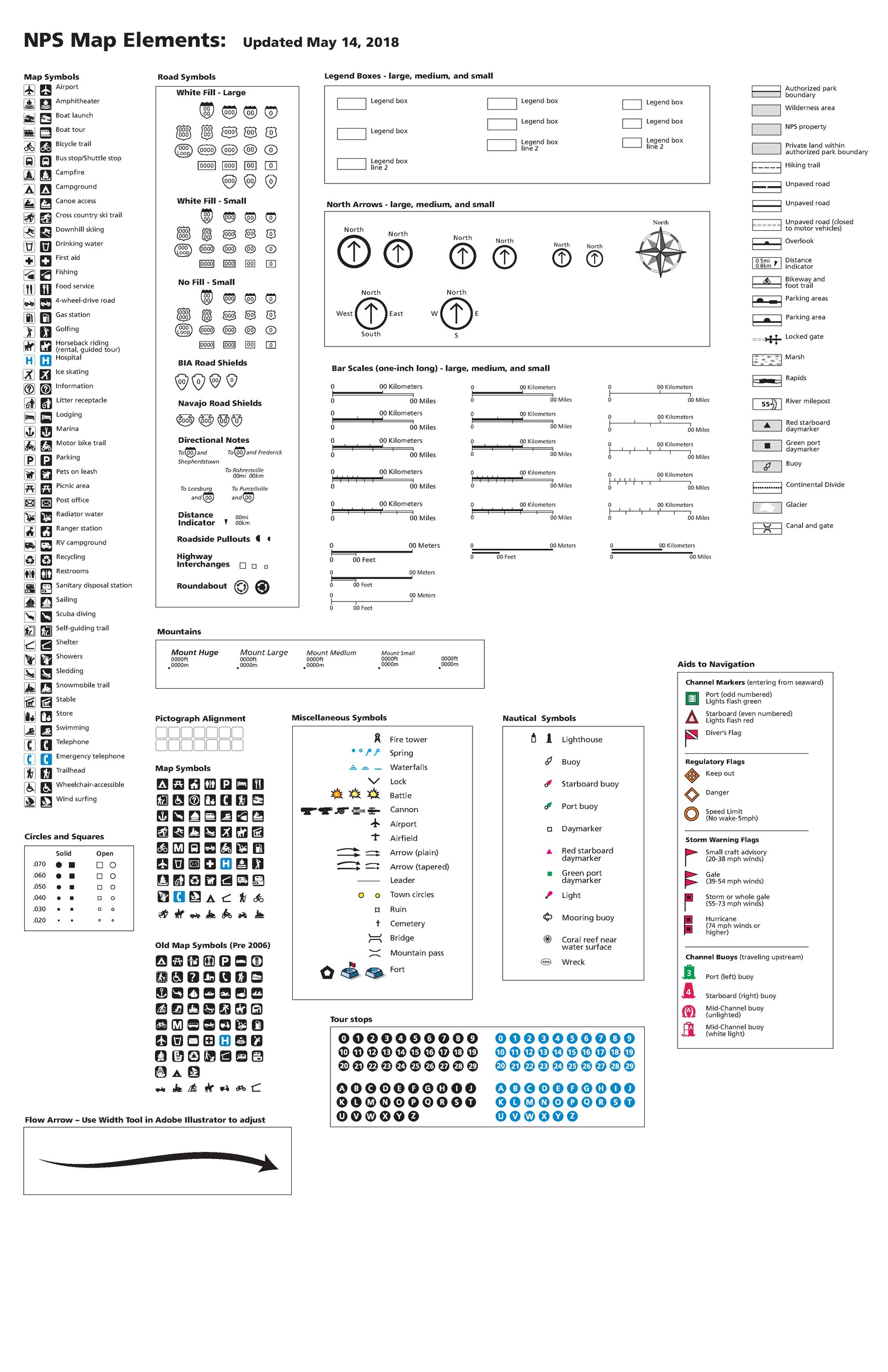
NPS Map Elements. This key of map symbols is made up of sixteen sections, all but one of which is labeled with a title. Most of the symbols are black and white but blue, red, yellow, or green are sometimes used. The document was updated May 14, 2018.
Screen-viewable file; Adobe print production files can be downloaded from the Compressed zip Version link
Map Projection: Other; Map Type: other
U.S. National Park Service
The National Park Service maps are government produced and are in the public domain. Anyone may, without restriction under U.S. copyright laws: Reproduce the work in print or digital form; Create derivative works; Perform the work publicly; Display the work; Distribute copies or digitally transfer the work to the public by sale or other transfer of ownership, or by rental, lease, or lending. Please note, a user who modifies and/or republishes National Park Service maps are responsible for any problems encountered with the maps, due to their change or modification.
Public domain
Document
NPS-wide, Code: NPS
Harpers Ferry Center, Code: HFC
Harpers Ferry Center, Code: HFC
NPS-wide
Harpers Ferry Center, Jefferson County, West Virginia
Latitude: 39.3233108520508, Longitude: -77.7410736083984
Harpers Ferry Center, Jefferson County, West Virginia
Latitude: 39.3233108520508, Longitude: -77.7410736083984
2018-05-09
Public Can View
Person: Harpers Ferry Center
Organization: US National Park Service
Address: Harpers Ferry Center, Harpers Ferry, WV
Email: HFC_Cartography@nps.gov
Organization: US National Park Service
Address: Harpers Ferry Center, Harpers Ferry, WV
Email: HFC_Cartography@nps.gov
Wednesday, April 27, 2022 8:15:41 PM
Friday, September 26, 2025 11:36:29 PM
map_elements.pdf
pdf
1.1 MB
Map