|
Glaciers were selected based on their geography, aspect, elevation range, shape, safety of access, and past monitoring efforts. After careful consideration of all 312 glaciers in the park, four were chosen: Noisy Glacier on Bacon Peak, Silver Glacier on Mount Spickard, North Klawatti Glacier on Primus Peak, and Sandalee Glacier on McGregor Mountain. 1) Noisy Creek Glacier is a cirque glacier located northwest of Bacon Peak, Bacon Peak quadrangle. Post et al. (1971) glacier number 2219-1. Characteristics of the glacier from a 1993 inventory include: area 0.58 km2, direct snowfall and minor snow drift accumulation, not appreciably crevassed, ends on moderate to gentle slopes, slight retreat in 1973, elevation range 1680m-1920m. Drainage basin: Baker Lake Watershed. 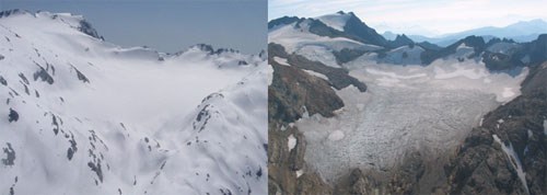
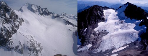
2) Silver Glacier is a cirque glacier located on the north side of Mt. Spickard, Mt. Spickard quadrangle. Post et al. (1971) glacier number 2236-6. Characteristics of the glacier from a 1993 inventory include: area 0.49 km2, accumulation sources direct snowfall and minor snowdrift, moderately crevassed, 1973 calved into Silver Lake and slight retreat, elevation range 2090m-2710m. Drainage basin: Ross Lake Watershed.
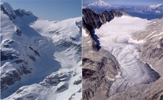
3) North Klawatti Glacier is a valley glacier located south of Primus Peak, Forbidden Peak quadrangle. Post et al. (1971) glacier number 2253-10. Characteristics of the glacier from a 1993 inventory include: area 1.48 km2, accumulation sources direct snowfall and minor snow drift, moderately crevassed, ends on moderate to gentle slopes, 1973 slight retreat, elevation range 1740m-2400m. The glacier has recently been studied by the USGS (Tangborn, Fountain and Sikonia, 1990; Meier, 1966). Topographic maps and data gathered during these investigations will be useful to this study. Drainage basin: Thunder Creek Watershed.
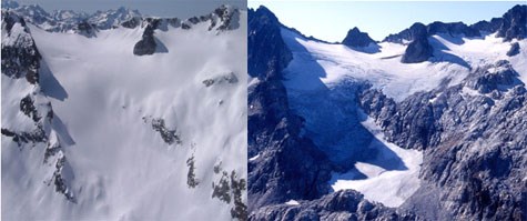
4) Sandalee Glacier is a cirque glacier located on the north face of McGregor Mountain (to the east of the Pacific Crest), McGregor Mountain quadrangle. Post et al. (1971) glacier number 2448-10. Characteristics of the glacier from a 1994 inventory include area 0.20 km2, elevation range 1975m-2350m, has gentle and steep slopes, is somewhat crevassed, and lies within a climate zone that is more continentally influenced than the other three glaciers monitered. Drainage basin: Stehekin River Watershed.
|
Last updated: August 11, 2017