Multnomah Falls, Oregon (NPS Photo)
Ice Age Floods |
1. Historic Trails
Oregon National Historic Trail
The general route of this trail stretches from Independence, Missouri, to Oregon City, Oregon. This 2,170-mile-long trail passes through Missouri, Kansas, Nebraska, Wyoming, Idaho, and Oregon. As the harbinger of America’s westward expansion, the Oregon Trail was the pathway to the Pacific for fur traders, gold seekers, missionaries, and emigrants. Beginning in 1841 and continuing for more than 20 years, an estimated 300,000 emigrants followed this route from Missouri to Oregon on a trip that took five months to complete.
The National Park Service Comprehensive Management and Use Plan describes the official route and lists 235 historic sites and seven cross-country segments. It also makes recommendations for resource protection, trail management, and markers. Many of the sites and segments are on public land and are open to visitors. Others are located on private lands. The approximate route can still be followed by automobile, and opportunities are available to travel by foot, horse, or mountain bike in many places. Information on trail routes and history is available from the National Park Service Long Distance Trails Office. Information on accessibility and travel conditions along the cross-country segments is best obtained from local offices of the Bureau of Land Management or the U.S. Forest Service.
Lewis and Clark National Historic Trail
In 1804, Meriwether Lewis and William Clark were sent out by President Thomas Jefferson to find a transportation link between the Louisiana Territory and the “Oregon Country.” In addition, Lewis and Clark were to acquire knowledge of the vast and unexplored west of the nation as they covered more than 8,000 miles in two years. As they journeyed from the Mississippi to the Pacific Ocean, they meticulously recorded observations of the characteristics, inhabitants, and resources of the country through which they passed. Their journey lit the imagination of the American people about this country and its destiny. Its scope and achievements have made the Expedition one of the most dramatic and significant episodes in the history of the United States.
Today it is possible to retrace portions of this historic route by following the Lewis and Clark National Historic Trail, which was Congressionally designated as the first Historic Trail in 1978. The water route taken by the Expedition can be retraced by boat, and some parts of the overland route have been or are being developed for travel by horseback, foot, and bicycle. Motor routes that approximately follow the route of the historic expedition are uniformly marked and connect a series of memorials, museums, visitor centers, interpretive exhibits, and historic sites along the trail. The National Park Service administrates the trail in cooperation with federal, state, and local agencies, nonprofit organizations, and private landowners. The Lewis and Clark National Historic Trail was recognized in 1999 as one of twelve National Millennium Trails.
2. Scenic Trails
Ice Age National Scenic Trail
The effects of the advancing and retreating glaciers of the last Ice Age created an unmistakable legacy in the State of Wisconsin. Thousands of formations left on the glacial landscape give the area its remarkable beauty and diversity.
In the 1950s, a 1,000-mile-long trail was first envisioned generally to follow the terminal moraines of the most recent glaciation and to connect Ice Age formations. In order to achieve this, a nine-unit Ice Age National Scientific Reserve was created in 1971. In 1980 Congress recognized the national significance of the trail by designating it a National Scenic Trail. The National Park Service administers the trail in cooperation with the Wisconsin Department of Natural Resources and the Ice Age Park and Trail Foundation. Much of the work to develop and maintain the trail has come from volunteers.
As of 1998, 227 miles of the trail have been certified by the NPS as part of the Ice Age National Scenic Trail. An additional 250 miles of completed trail segments are also open for public use and enjoyment for auto tours, hiking, cross-country, and nature walks.
Natchez Trace National Scenic Trail
The Natchez Trace National Scenic Trail is 694 miles in length and located in Alabama, Mississippi, and Tennessee. The Trail Segments include several existing portions of the historic Natchez Trace that lie within the boundaries of the Natchez Trace Parkway. Completed sections of this trail are found alongside the Natchez Trace Parkway near Rocky Springs and Jackson, Mississippi, and Nashville, Tennessee. The trail is also a unit of the National Trails System and was established March 28, 1983. Public-use opportunitities consist of auto tours, guided tours, biking, hiking, and nature walks.
Potomac Heritage National Scenic Trail
The designation of a Potomac Heritage National Scenic Trail corridor, enacted and signed in 1983 as an amendment to the National Trails System Act, is being used by communities in Virginia, Maryland, the District of Columbia, and Pennsylvania to develop and make connections among trails, historic sites, and a range of recreational and educational opportunities. Three trails are currently recognized as “official” segments of the Potomac Heritage National Scenic Trail: the 184.5-mile C & O Canal Towpath, managed by Chesapeake & Ohio Canal National Historical Park; the 17-mile Mount Vernon Trail, managed by George Washington Memorial Parkway; and the 75-mile Laurel Highlands Trail, managed by Laurel Ridge State Park, Pennsylvania Department of Conservation and Natural Resources.
Existing trails are complemented by many local and regional trails, on land and water, with many more in the early stages of development. Local governments and citizen groups are using the corridor designation (1) to support a variety of trail projects, (2) to increase educational, conservation, and development opportunities, and (3) to realize benefits from the extensive growth in ecotourism.
3. National Heritage Trail
New Jersey Coastal Heritage Trail
The New Jersey Coastal Heritage Trail project was conceived and designed to recognize the importance of New Jersey’s coastal area in our nation’s history. The trail’s project area stretches more than 275 miles along the New Jersey coast. The trail’s authorizing legislation directed the NPS, in cooperation with the State of New Jersey, other Federal agencies, local governments, and private entities, to inventory sites within the project area and to prepare a plan for protecting and interpreting those sites.
The heritage of the New Jersey coastal area is explored through interpretation of five interrelated themes—maritime history, coastal communities, relaxation and inspiration, coastal habitats, and wildlife migration. Each theme is based upon aspects of the area’s heritage, and together they illustrate the interaction of natural and cultural influences and the coastal environment.
The New Jersey Coastal Heritage Trail project is being developed and implemented through the cooperative efforts of the Federal government, the State of New Jersey, county and city governments, nonprofit organizations, and individual site managers. The NPS is the Federal government’s lead agency on this project. Although primarily a vehicular route along public roads, the Trail connects coastal areas with their local recreational opportunities into an overall trail package.
4. National Heritage Corridors
Illinois and Michigan Canal National Heritage Corridor
The Illinois and Michigan Canal National Heritage Corridor was created in 1984 when Congress enacted legislation that recognized the area’s unique contributions to the nation’s development. Public Law 98-398 established a corridor defined by the Illinois and Michigan Canal from Chicago to LaSalle, Illinois. It also established the National Heritage Corridor Commission to be made up of 19 members. They include the Director of the NPS, three representatives of state and local governments, five members nominated to represent the interests of history/archaeology/recreation/conservation, five members nominated to represent the interests of business/industry, one member of the county board representing each county, and one member of the board of a forest preserve district.
Formed by business and community leaders from northeastern Illinois to promote Federal designation of the Illinois and Michigan Canal National Heritage Corridor, the Canal Corridor Association is a nonprofit organization managed by a volunteer board of business, industry and community leaders, and a professional staff. The Association works toward the economic revitalization of the Illinois & Michigan Canal National Heritage Corridor by drawing on the shared past of a region founded on the nineteenth-century I & M Canal, by forging public and private partnerships, and by offering technical assistance in historic preservation, land conservation, and economic development.
Blackstone River Valley National Heritage Corridor
The Blackstone River Valley illustrates a major era of America’s past: the Age of Industry. The communities along the banks of this river were the first to experience the change brought about by the revolutionary way of using waterpower and labor in America. They evolved from an isolated agrarian society to industrialized interdependent communities. Evidence of the way people lived during this turning point in history can be seen in the thousands of structures and landscapes still found in the area, such as mill villages, roads, trails, dams, mill ponds, agricultural and natural environments, and ethnic traditions in neighborhoods, languages, and foods.
The Blackstone River Valley National Heritage Corridor is a region of nearly 400,000 acres located in central Massachusetts and northern Rhode Island. The National Corridor was designated by an Act of Congress in 1986 to preserve and interpret the unique and significant value of the Blackstone Valley. It includes cities, towns, villages and almost one million people. The Federal government does not own or manage any of the land or resources in the corridor. Instead, the National Park Service, two state governments, dozens of local municipalities, businesses, nonprofit historical and environmental organizations, educational institutions, private citizens, and a unifying Commission work together in partnerships to protect the Valley’s special identity and prepare for its future. The Corridor can be seen by bicycle, watercraft, train, automobile, and foot.
Delaware and Lehigh National Heritage Corridor
The Lehigh Navigation System and the Delaware Canal, constructed from 1817 to 1845, opened the region and its resources to development, brought great wealth, spurred industrial innovations, and led to the founding and growth of today’s canal towns. It was America’s last and longest operated towpath canal, and it is now the most fully intact and accessible towpath canal in the nation. The canals are the threads that connect the rich historic, cultural, and recreational resources of the Corridor.
The Delaware and Lehigh Canal National Heritage Corridor is a 150-mile-long region in eastern Pennsylvania that follows the historic routes of the Delaware Canal and the Lehigh Navigation System. Within the corridor are scenic rivers, historic canals and towns, mountains, green valleys, natural areas, recreation, remnants of early industries, distinctive religious heritage, and active cultural arts. Designated by Congress in 1988, this Heritage Corridor is now the subject of an intensive, cooperative effort by citizens to plan for conservation of the valley’s heritage and the enhancement of the region’s quality of life. Many partnership organizations and agencies, at local, state, and federal levels, act to collaborate for the Corridor’s future. There are many ways to enjoy the Corridor, including hiking, auto tours, and boating. The entire Delaware Canal Towpath and 32 miles of the Lehigh Towpath are National Recreation Trails.
Quinebaug and Shetucket Rivers Valley National Heritage Corridor
Quinebaug and Shetucket Rivers Valley National Heritage Corridor encompasses about 850-square-miles in the northeastern corner of Connecticut. Stretching from Norwich north to the Massachusetts border and from Coventry east to Rhode Island. It has been called “the last green valley” in the Boston-to-Washington megalopolis. Close to Hartford, Providence, and Worcester but far enough away to avoid the urban sprawl of recent years, this region remains predominately rural. Roadways winding through rolling hills link the region’s many small towns, villages, farmlands, and forests. Old mills dot the lowlands along the Quinebaug and Shetucket rivers and their tributaries.
In the past 50 years, many changes have come to this area. Many of the farms and factories have been put to new uses, such as housing, antique and craft shops, recreation, and high-tech industry. Amid these economic changes, this region has retained its fundamental attributes of lush woodlands, clean streams, rivers, ponds, and lakes; authentic sites representing distinct periods of American history; and opportunities for individuals and families to enjoy a rural, small-town lifestyle.
Quinebaug and Shetucket Rivers Valley National Heritage Corridor is a special kind of park in that it embraces 25 towns with numerous villages and a total population of about 250,000. The federal government does not own or manage any of the land as it does in traditional national parks. Instead, citizens, businesses, nonprofit cultural and environmental organizations, local and state governments, and the National Park Service are working together to preserve the region’s cultural history and to perpetuate its natural heritage.
5. National Scenic Area
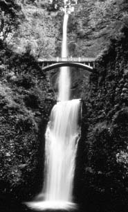
Columbia Gorge National Scenic Area
|
|
|
|
Multnomah Falls, Oregon (NPS Photo) |
The Columbia River Gorge is a spectacular river canyon cutting through the volcanic rock of the Cascade Mountain Range. As the only sea-level river flowing through the Cascades, the Columbia is both a natural wonder and an important transportation corridor. Recognizing this interest, Congress passed an act creating the 292,000-acre Columbia Gorge National Scenic Area, which is managed by the U.S. Forest Service. There are many recreational opportunities in CGNSA, including windsurfing, boating, hiking, auto tours, biking, and other activities.
Along with other interpretive themes, the Columbia Gorge National Scenic Area does provide some interpretation of the Ice Age Floods story.
6. National Historic Parks
Klondike Gold Rush National Historic Park
There are two units of the Klondike Gold Rush National Historical Park: one in Seattle, Washington, and one in Skagway, Alaska. The Seattle Unit of the Klondike Gold Rush National Historical Park commemorates the city’s role as the most important staging area for the gold rush of the 1890s.
In Skagway, Klondike Gold Rush National Historical Park lies in one of the world’s most spectacular geographic areas, characterized by an almost endless array of islands, mountains, glaciers, rivers, lakes, and forests. Fortunately, within this unspoiled geographic setting, the United States and Canada have been able to preserve a wealth of historic structures and artifacts. Visitors, particularly those that hike the Chilkoot Trail, are likely to see these last tangible reminders of the gold rush days: telephone wire and poles, boots, bedsprings, horseshoes, and rusty cookware, to name a few. The park in Skagway preserves a dozen gold rush–era buildings, forming the heart of the historic district. The park and town are popular summer destinations for road and cruise ship passengers. The contrast between the scenic grandeur and the humble remains of the stampeders’ possessions and temporary structures is what helps to make a visit to the park an unforgettable experience.
Nez Perce National Historic Park
There are 38 separate sites of the Nez Perce National Historic Park scattered across the states of Idaho, Oregon, Washington, and Montana. They have been designated to commemorate the legends and history of the Nez Perce people and their interaction with explorers, fur traders, missionaries, soldiers, settlers, gold miners, loggers, and farmers who moved through or into the area.
The areas encompassing these sites display the great diversity of the American West—topography, rainfall, vegetation, and scenery—ranging from the semiarid regions of Washington, to the lush high mountain meadows of Idaho and Oregon, to the prairies of Montana. As you travel from site to site, one gradually senses the importance of the land in contributing to the rich and diverse cultural history of the Nez Perce people.
Touring this park is unlike traveling in most parks, for this one is as much an idea as it is actual physical property. In some cases the idea is the stronger force, for the physical remains of the past have either disappeared or the original appearance has been greatly altered.
7. National Reserves
Ice Age National Scientific Reserve
Some of the effects of the most recent advance of the continental ice sheet, the Wisconsin Stage, are dramatically evident in the state of Wisconsin. Striking evidence is visible in drumlins, kames, kettles, glacial lakes, moraines, and eskers scattered throughout the landscape. The Ice Age National Scientific Reserve was created to preserve and protect this legacy of the last glacial stage.
The Ice Age National Scientific Reserve is composed of nine units containing resources significantly characteristic of the continental glaciation in Wisconsin. Collectively these units are approximately 32,500 acres in size and are connected by the 227-mile long Ice Age National Scenic Trail. As authorized by Congress, management of the Reserve is a cooperative venture of federal, state, and local governments to preserve and interpret these resources.
8. Other
The Seaway Trail
The New York State Seaway Trail is a 454-mile scenic route that runs parallel to Lake Erie, the Niagara River, Lake Ontario, and the St. Lawrence River. The Trail passes through 10 counties and connects cities, villages, fishing ports, state parks, museums, and 42 historic sites. The Trail is noted for its mixed usage by automobile, bicycle, bus, motorcoach, and RVs. The Seaway Trail was selected as a National Scenic Byway by the U.S. Department of Transportation due to its unique landscape, which has been sculpted by the forces of nature and has great historical interest.
The Trail is managed and marketed by Seaway Trail, Inc., a private corporation that was created in 1978 “to promote the Trail as a tourist destination and encourage regional economic development through tourism (emphasis added).”
It is interesting to note that the purpose of the Trail is tied directly to tourism and economic development, recognizing the economic benefits of tourism.
|
|