|
Contact: Shannan Marcak, 928-638-7958
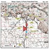
Grand Canyon, AZ. -- Grand Canyon National Park fire managers will be implementing up to three prescribed fires on the South Rim this spring: the Picnic Prescribed Fire, the Quarry Prescribed Fire and the Moqui Prescribed Fire. (A map of these prescribed burn units can be downloaded in .pdf format at the bottom of this page.) Plans call for these prescribed burns to be initiated individually within the next 30 days. The Picnic burn unit is 222 acres in size and is located approximately 3 miles north of Tusayan and 1.25 miles south of Grand Canyon Village adjacent to Highway 64 (Hwy 64) on the east side of the highway. (See attached map.) This unit starts at the junction of Center Road and Hwy 64 within the park and runs south (toward the park exit) along Hwy 64 for approximately 1.5 miles. The primary fuels in this unit are ponderosa pine and pinyon/juniper stands with some grasses and brush. The Picnic unit last burned in 2000. The Quarry burn unit is 319 acres in size and is located approximately 2 miles north of Tusayan and 2.25 miles south of Grand Canyon Village on the west side of Hwy 64. No portion of the Quarry burn unit is immediately adjacent to the highway. The western boundary of this burn unit borders the Kaibab National Forest and the southern edge borders the northern edge of the Moqui burn unit. This burn unit contains ponderosa pine and pinyon/juniper stands as well as grass and brush. The Quarry unit last burned in 2000. The Moqui burn unit is 743 acres in size and starts at the south boundary of Grand Canyon National Park in the immediate vicinity of the South Entrance Station. It then runs north along the west side of Hwy 64 for approximately 2 miles. The Moqui burn unit is bordered on the west by the Kaibab National Forest boundary and on the north by the Quarry burn unit. This burn unit contains ponderosa pine and pinyon/juniper stands as well as grass and brush. The Moqui unit last burned in 1996. Fire managers plan to burn these units one at a time, starting with the Picnic unit, the farthest unit from the South Entrance Station and the town of Tusayan. After the Picnic burn is completed, fire managers will move on to the Quarry Prescribed Fire. The smoke impacts from both of these fires will be assessed before a final decision is made to initiate the Moqui Prescribed Fire. If the smoke impacts exceed fire managers’ expectations, the Moqui Prescribed Fire will not be initiated. Additionally, if the Moqui burn is initiated, fire managers plan to burn only the northern half of the unit. This would keep fire activity at least one half mile north of the South Entrance Station. The Arizona Trail runs through portions of these burn units. During the prescribed fires, these portions of the trail will be closed. Signs will be posted on the trail where it enters the burn units advising trail users of the fire activity and providing alternate routes. Prescribed fires are used by fire managers as a tool to achieve defined resource objectives and to reduce dangerous accumulations of fuels which increase the potential for wildland fire hazards. The resource objectives of these three prescribed fires are to use fire to decrease risks to life, property and resources by reducing accumulations of forest fuels, and to maintain fire in a fire-dependent ecosystem. Based on the objectives they wish to achieve, fire managers develop a plan for each prescribed fire. Each fire’s plan contains a prescription—a set of parameters that define when fire managers can initiate burning based on environmental factors such as wind, relative humidity, temperature and expected weather patterns, and on fuel conditions. If all prescriptive parameters within a fire’s plan are not met, the fire will not be started. During these prescribed fires, smoke impacts may occur on Hwy 64 between the park entrance and Grand Canyon Village. Fire activity, including personnel and equipment may also be visible along this road. Signs will be posted advising visitors and motorists of possible smoke impacts. Coordination with the Arizona Department of Environmental Quality; Kaibab National Forest, Tusayan District; and Arizona Public Service is already occurring. For information on plans for South Rim prescribed fires, please call 928-638-7958. To learn more about fire management in Grand Canyon National Park, visit the park’s web site at www.nps.gov/grca/parkmgmt/firemanagement.htm. -NPS- 
|
Last updated: December 30, 2017
