|
Visit our keyboard shortcuts docs for details
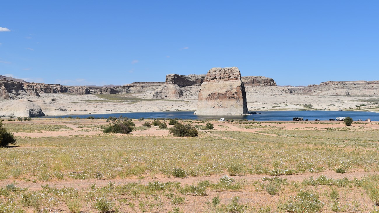
A compilation of still images taken from the Wahweap View of a portion of Lake Powell April - December 2023. The drastic change in the water level is shown through the passage of time. This video has no audio. Glen Canyon is home to dynamic and constantly changing landscape.Since 2001, declining water levels due to climate change and 20 years of drought have reshaped Lake Powell’s shoreline. Today we are experiencing low lake levels and their effects on boat ramp access points, on-lake facilities, and the landscape.
For real time lake level information, view the Bureau of Reclamation's Upper Colorado River HydroData. To learn more about the Upper Colorado River Basin and the operations of Glen Canyon Dam, including the 24-month predictions, visit the Bureau of Reclamation's website. Lake Powell Current Water LevelLake Powell Elevation (4/24/2024)3558.79 ftLake Level Effects to Launch Ramps and Services
Lake Powell Water Access Update - Letter from the Superintendent November 2023It gives me great pleasure to share some very good news with park partners! Glen Canyon National Recreation Area has received $166 million in Fiscal Year (FY) 23 Disaster Supplemental funds to address low water related infrastructure projects. We were informed of this about three weeks ago when the Office of Management and Budget approved the budget from Congress for the climate related disaster projects. We are prioritizing a relocated Hite takeout for Cataract Canyon river trips, a mid-lake fuel station, and sustainable deep-water access at the Antelope Point Public Ramp. Also included in this funding package is a project for lake-wide salvage of derelict vessels, a new dock system for Rainbow Bridge National Monument, and continued extension of the Stateline Auxiliary Ramp. A once in a generation project will include cultural surveys of lake shorelines that become exposed as the water levels recede. We have been planning for many months and I am happy to confirm that the funds are approved to move all of these efforts forward to construction and completion! Timelines will be dependent on how quickly our design services offices develop contracts, and we are working hard with them to make things happen! Sincerely, One of our first larger projects planned in this location was a project for a low boat ramp at Bullfrog Stanton Creek. The Bullfrog Stanton Creek location offers lower elevation ramp possibilities. With the updated Bureau of Reclamation target elevation commitment for Lake Powell at an elevation of 3525 and existing Bullfrog ramps already providing access as low as 3519, an investment in that Bullfrog Stanton Creek ramp is not as urgent currently. The design and costing work we have done with that project may still be useful in the future so it is an option we have in our back pocket for lower water levels should they be forecasted again. We have not stopped evaluating and pursuing federal and state grant opportunities (in collaboration with the state of Utah) to resume ferry access in this area. This ramp is currently open to paddlecraft only. Planning and design continues for a construction project which would extend this ramp to enable public water access for a variety of user groups. The Park is working with the Navajo Nation to determine the preferred design option. The contractor will finalize this work into a report for the park to move the project to schematic design next. The park received FY 23 disaster supplemental funding for this project. This funding will cover design to construction of this project. The NPS (Glen Canyon NRA and Canyonlands National Park), the economy of Utah, and the river rafting community are affected by the need for a sustainable takeout ramp at Hite for Colorado River trips in Cataract Canyon. Glen Canyon secured FY 23 Disaster Supplemental Funding to rapidly advance the planning and design for a new river takeout ramp that will be more sustainable long-term. This will fund a design build contract for this project, restoring access to the river at Hite. NPS had previously undertaken hydrology assessments that have identified feasible recommended locations. The location selected for this new ramp is on the south side of the Colorado River, just west of the bridge at Hite. We are moving quickly to obtain schematic designs and begin our environmental assessment process. A design build contract, which culminates in construction, will then be announced by our project managers at Denver Service Center. We don’t have solid dates for construction start and completion at this time. Once we have schematic designs, the NPS will begin the environmental and cultural compliance process. That National Environmental Policy Act (NEPA) process will inform our contracting timelines for a design build contractor. We will share updates as they become known and after we have the schematic design for the ramp. We appreciate your interest and look forward to working with all interested and affected parties on this. As previously communicated, low water infrastructure is not feasible at the former Dangling Rope location. Access has been restored to Rainbow Bridge for the summer season in July. Infrastructure has been relocated to support visitation and boat tours to this popular destination on Lake Powell. Concession-operated boat tours are resuming. We are making progress on the contracting documents package for our Great American Outdoors Act (GAOA) funded Utilities Project for Wahweap and Lone Rock water and wastewater systems. The projects will be severed into two phases of work. The wastewater phase will begin first as we continue to pursue the best possible option for a sustainable and best quality drinking water source. We anticipate soliciting for contractor proposals on the wastewater phase in March 2024. 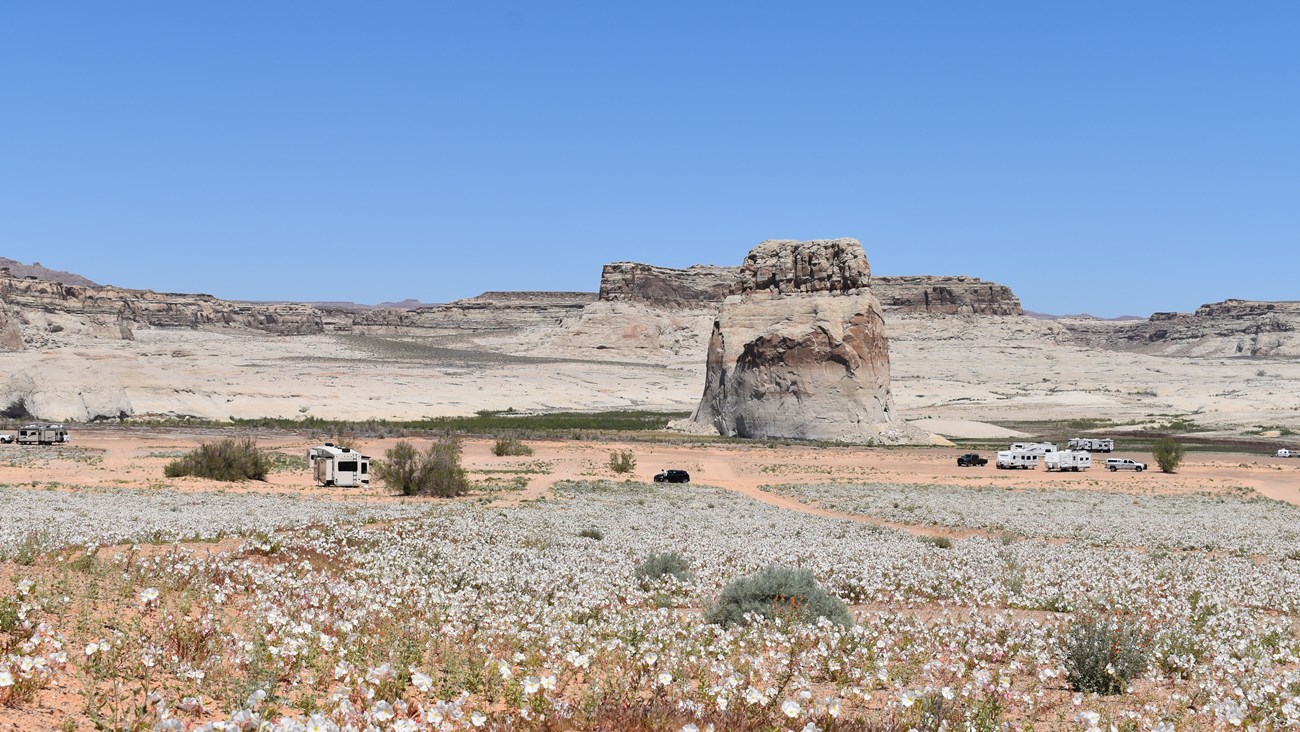
Left image
Right image
Lake Powell Launch RampsRecreate Safely at Lake Powell
| |||||||||||||||||||||||||||||||||||||||||||||||||||||||||||||||||||||||||||||||||||||||||||||
Last updated: April 25, 2024