| |
 |
| Primm Valley Resort, Nevada December 3 - 7, 2001 |
| |
 |
Field Trip Information
Urban Sprawl and Mojave's new Airport
 Public Lands in the Ivanpah Valley--along I-15 between Jean, Nevada and Primm, Nevada (the conference location)--have been designated to be transfered from BLM jurisdiction for the development of a large commercial airport. This airport would have a number of potential impacts on Mojave National Preserve, and GIS is one of the tools being
used to evaluate these threats. This threat comes in the wake of the rapid urban sprawl of the greater Las Vegas area and Clark County. What are some of the impacts of sprawl on park resources and how do we quantify those impacts in terms of resources such as sound, viewsheds, and wilderness qualities. Trip will involve visiting the proposed airfield site and the desert tortoise preserve nearby. Discussion with planners of the quantification of sounds, sights, and experiences as a GIS process.
Public Lands in the Ivanpah Valley--along I-15 between Jean, Nevada and Primm, Nevada (the conference location)--have been designated to be transfered from BLM jurisdiction for the development of a large commercial airport. This airport would have a number of potential impacts on Mojave National Preserve, and GIS is one of the tools being
used to evaluate these threats. This threat comes in the wake of the rapid urban sprawl of the greater Las Vegas area and Clark County. What are some of the impacts of sprawl on park resources and how do we quantify those impacts in terms of resources such as sound, viewsheds, and wilderness qualities. Trip will involve visiting the proposed airfield site and the desert tortoise preserve nearby. Discussion with planners of the quantification of sounds, sights, and experiences as a GIS process.
DATE: Monday, December 3
COST: $25
TIME: 9:30-3:30
Desert Tortoise Recovery
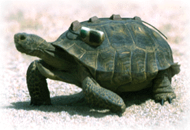 Learn about monitoring and mapping a cryptic threatened resource. The desert tortoise was listed as threatened in 1990 under the Endangered Species Act. The Recovery Plan calls for the monitoring of desert tortoise populations and mapping of critical habitat. Spend a day in the field with desert tortoise researchers in Lake Mead showing how GPS and GIS are integrated for tracking an animal that spends the majority of its time underground. Some additional applications of field techniques with the desert burro issues will also be demonstrated.
DATE: Monday, December 3
COST: $25
TIME: 8:00-1:30
The Alien Invasion
 Exotic Weeds and insects comprise the biggest threat to desert landscapes. Imagine that many of the plants associated with the desert today are not native and were introduced by cattleman or careless homeowners. Mapping the spread of exotics and the field verification of the data is one of the bigger challenges for natural resource management specialists in the desert regions. The trip will look at vegetation mapping protocols, accuracy and precision in the field between aerial photography and polygon delineation. Discussion of on-going vegetation mapping projects in several of the desert parks.
DATE: Monday, December 3
COST: $25
TIME: 9:30-3:30
|
CONFERENCE GUIDE
|
|