
| GIS Day 1999 | |
|
From
Our Newest National Park
|
 |
|
Protecting
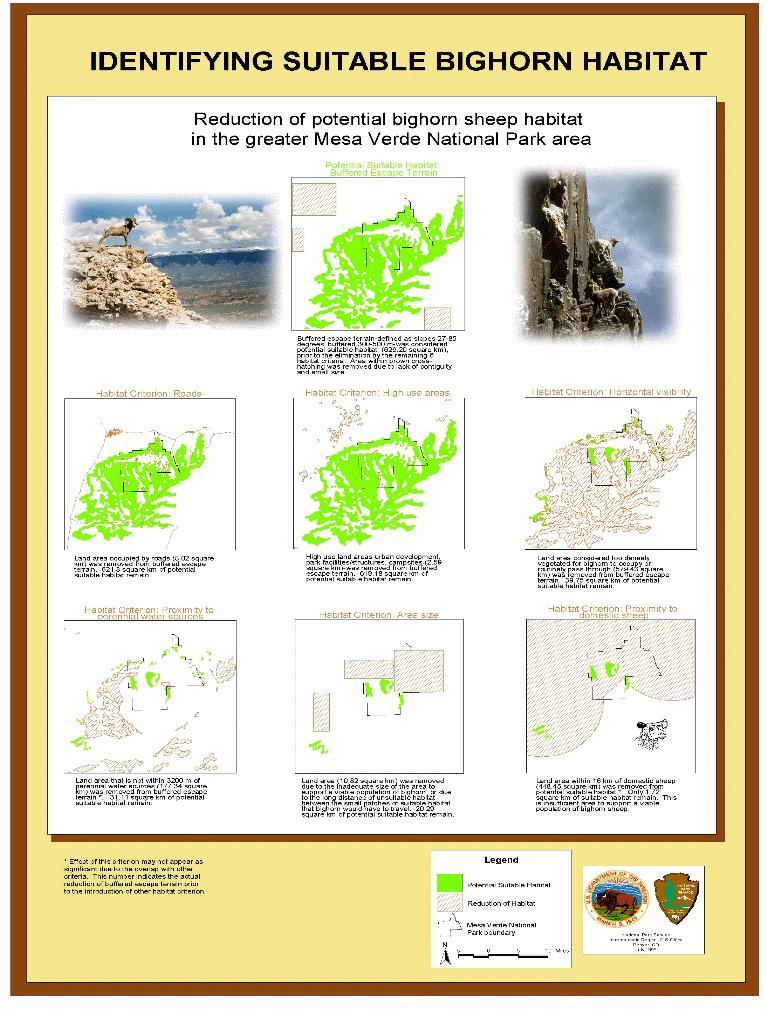
Natural Resources Bighorn sheep (Ovis canadensis) once were ubiquitous in large areas, including lands now contained in the national parks of the Intermountain and Colorado Plateau regions of the United States. Due to catastrophic declines in the late 1800s and early 1900s, most extant populations now occur as small, isolated groups with a highly fragmented distribution. Three different subspecies of bighorn sheep were extirpated from 14 of 18 areas that are now managed by the National Park Service. We describe an 8-year restoration plan to restore bighorn sheep to currently suitable historic habitats in the national parks within a 6-state intermountain region of the western United States, 1991-98. The scientific advisory panels, and the GIS modeling, recommended 73 sites within these areas were suitable for bighorn restoration. By 1996, 36 of these sites were inhabited by bighorn sheep. By 1999, the translocated animals increased 25%, and restoration efforts will continue in many of the remaining sites. Associated 4.3MB PDF Presentation |
 |
|
Seashore Restoration
Cape Cod
National Seashore
GIS is helping in the planning and restoration of the Hatches Harbor Habitat. The Cape Cod National Seashore is in the middle of an exciting environmental restorati on project. The Seashore is partnering with the Town of Provincetown to restore 90 acres of a 200 acre salt marsh adjacent to the Provincetown Municipal Airport. |
|
| And the management of the Herring River Habitat. Since 1908, human activities, primarily diking and drainage, have radically changed the way th e ecosystem operates. Most of these changes (e.g. wetland loss, water quality degradation) ha ve gradually destroyed many of the marshland's native values to people. |
|
|
Developing
Custom Management Tools The Coastal Resources Inventory Database was developed to enable managers with limited GIS skills to quickly access all the data collected using the Coastal Resource Inventory and Mapping Protocol. On opening the database, the manager is presented with a locator map showing all of Glacier Bay's 1100 miles of coastline. By rubberbanding a few boxes around the area of interest, the manager can quickly zoom in to a specific location. Selecting the appropriate polygon in the locator map brings up a close-up of the polygon with the appropriate aerial photo as the backdrop in the detail map on the left. The images taken in the polygon are displayed above the maps. All the field data collected during the inventory process is available via the tabs above the maps. The manager can 'walk the coast' by using the Page Up or Page Down key to move the record selection. The maps and records update as you 'walk' along. In a matter of seconds the manager has found all the available inventory data for a very specific location. The system provides very rapid access to gigabytes of data. |
 |
|
Evaluation of AutoDesk MapGuide - Inter-Mountain Regional Office Support data. |
 |
|
Managing
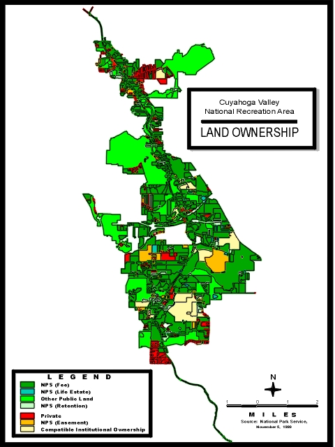
and Understanding Park Resources Cuyahoga Valley National Recreation Area (CVNRA) managers recognize that Geographic Information System (GIS) technology can aid them in managing and understanding the park's resources. A good example of this is our Land Ownership map. The ownership map is not a legal document rather it is a tool to meet the staff's need in accessing information on a given parcel of land that in the end improves our management of the park's resources. This is especially true in CVNRA where one-third of the land is either privately owned (Private) or managed by other public agencies (Other Public Land). Where non-federally owned land does exist, it is often necessary to acquire those lands and or interests in those lands to effectively manage and protect the park resources (NPS (Easement)), (NPS (Retention)), and (NPS (Life Estate)). For example, easements involve rights held by others to use one's land for special purposes. In the CVNRA, the special purpose is for the scenic value of the land and or historic preservation. In addition, the NPS will often form agreements with its neighbors that do not involve federal acquisition of any interest in real property. In the CVNRA, this is represented by the presence of Boy Scout and Girl Scout camps, ski resorts, golf courses, and other compatible recreational land uses (Compatible Institutional Ownership). The American public has entrusted the National Park Service (NPS Fee) with the responsibility to conserve, protect and manage the "historic, scenic, natural, and recreational" resources within the Cuyahoga Valley. GIS technology is helping us better serve the public's trust. |
 |
|
Brining
History Alive
Troop Movements
- Gettysburg
National Military Park
|
|
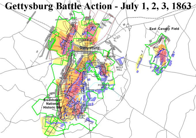
| A detailed view of the troop positions and levels of battle action for July 2, 1863 at Gettysburg.Yellow is used to indicate minor action, orange to indicate moderate action and red to indicate severe action. The woods as they existed in 1863 are shown using a green cross-hatch. This view extends from Barksdale's (CSA) breakthrough at the Peach Orchard (left edge) to Vincent's (USA) defense of Little Round Top (right edge).Modern roads are shown in black and the authorized park boundary is shown in dark green. | 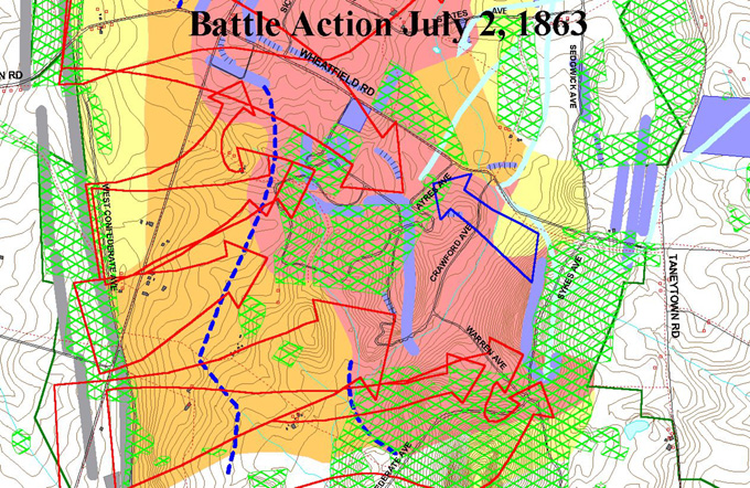 |
|
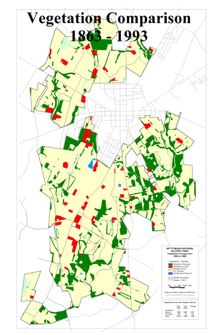
Battlefield
Landscapes |
 |
|
Park
Tour
- Rocky Mountain National Park
|
 |
|
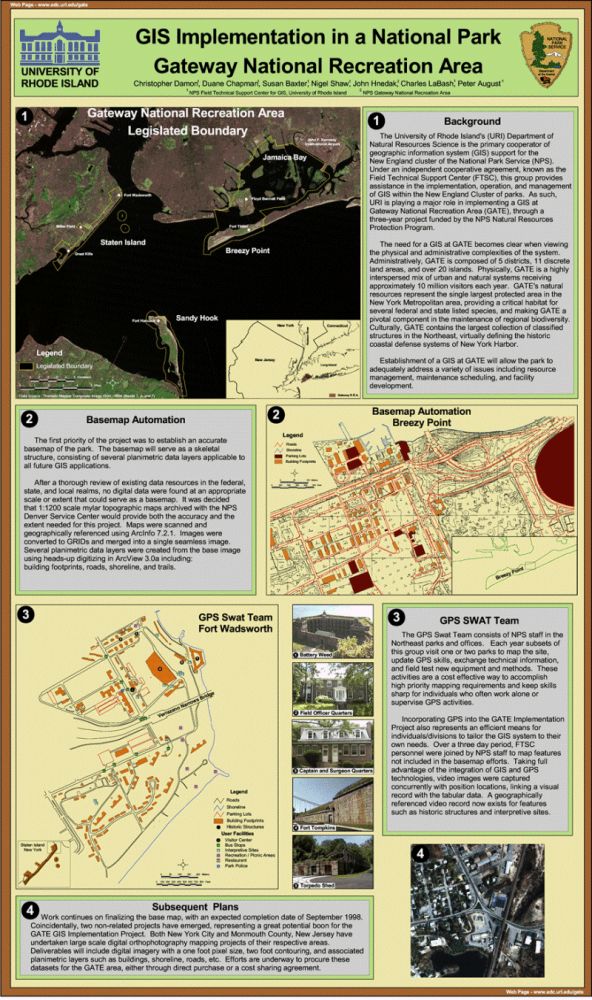
Park
Management and Administration This poster highlights the steps taken to date in implementing a GIS at Gateway National Recreation Area. Establishment of a GIS at GATE will allow the park to adequately address the complex physical and administrative issues faced in resource management, maintenance scheduling, and facility development |
 |
|
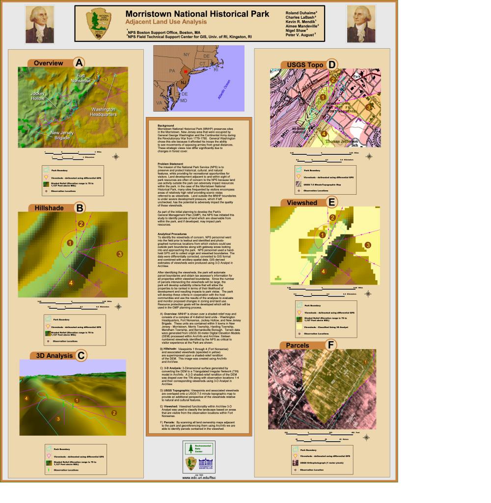
Impact
of Development This poster highlights research conducted at Morristown National Historical Park, Morristown, New Jersey. This research focuses on land development adjacent to the park and the impact development has on scenic views from within the park. |
 |
|
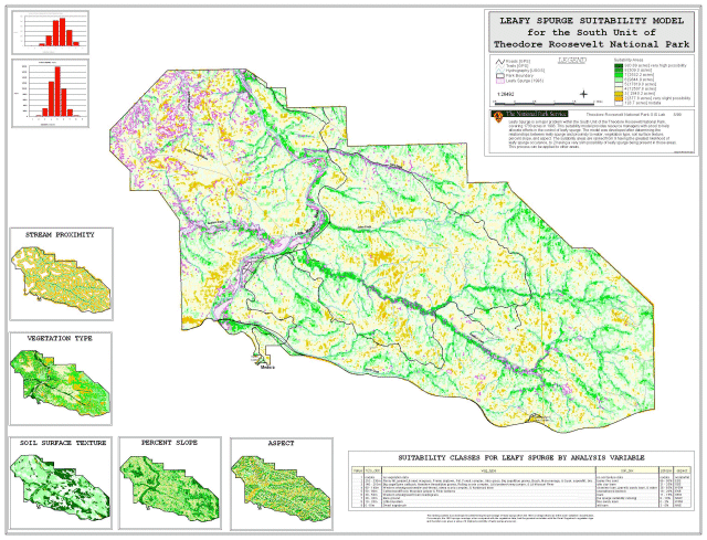
Protecting
Resources from Natural Threats Leafy Spurge Suitability Model for Theodore Roosevelt National Park - Medora, North Dakota Leafy spurge is a pervasive noxious weed that is the primary resource threat to the park and to the region. The GIS analysis utilized soils, digital elevation model, hydrography and vegetation to identify areas within the park that are suitable for leafy spurge infestation. Park managers are using this information as a planning tool for mitigation efforts. |
 |
|
GIS
Day 2000 Gallery | 2001 Gallery| 2002 Gallery
|