
DEPARTMENT OF THE INTERIOR REMOTE SENSING ACTIVITIES
Leslie Armstrong
National Park Service
GIS Program Manager
12795 W. Alameda Pkwy
Lakewood, CO 80228
ABSTRACT
This paper provides an overview of recent remote sensing projects and programs at the Department of the Interior. A general description and comparison of the Department of the Interior (DOI) bureau activities, programs and budgets is included along with bureau specific examples and case studies. Remote sensing and global positioning systems are used extensively in mapping, monitoring and mandated land management activities and plans. DOI bureaus are prototyping new techniques and systems in cooperation with the private sector, NASA and each other to improve and produce spatial information for decision-making, regulatory enforcement and preservation of our nation's resources.
INTRODUCTION
The Department of the Interior consists of eight separate bureaus, that each manages a variety of remote sensing activities and programs. The eight DOI bureaus are the Bureau of Land Management, Minerals Management Service, Office of Surface Mining Reclamation and Enforcement, United States Geological Survey, Bureau of Reclamation, Fish and Wildlife Service, National Park Service and Bureau of Indian Affairs. The programs range from the operation and management of the Landsat 5 and 7 program at the U.S.Geological Survey (USGS) EROS Data Center to over two million miles of annual waterfowl aerial surveys by the Fish and Wildlife Service. A general overview of these activities, programs and projects is the subject of this paper.
To facilitate coordination of mapping and spatial data activities the DOI created the Interior Geographic Data Committee (IGDC). Two IGDC working groups address remote sensing the Remote Sensing Working Group (RSWG) and the Base Mapping Working Group. The Remote Sensing Working Group chaired by Larry Pettinger, USGS, who coordinates and communicates with other branches of the government, public and commercial businesses on issues related to remote sensing and global positioning systems (GPS). The Base Mapping Working Group, chaired by Richard Kleckner, USGS, coordinates and funds the acquisition of commercial satellite imagery as well as other types of standard cartographic data, over DOI lands and areas of interest required by two or more bureaus. This group issues an annual requirement solicitation to DOI bureaus from which an imagery purchase and base data production program is executed.
Federal agencies including DOI bureaus participate in the Civilian Applications Committee (CAC), chaired by USGS, to coordinate policy, standards, and use of classified imagery for civilian agency missions. Custom and derived products are developed for emergency response, fire management and other natural disaster studies, and provide much needed base mapping imagery for remote areas in Alaska and the Pacific islands where commercial imagery or aerial photography is difficult or impossible to acquire. Under the CAC, the Global Fiducials program archives and facilitates the use of a long-term observational record of a predetermined set of sites, valuable in identifying and understanding environmental processes, variations, and changes that occur over years or decades.
The DOI spent an estimated 59 million dollars on remote sensing and GPS in fiscal year 2001. A break down of DOI expenditures by year and bureau is included in Table 1. This information was gathered by the RSWG for the National Aeronautics and Space Report 2001, compiled by the National Air and Space Administration (NASA) each year. The USGS, Bureau of Reclamation (BOR), and the National Park Service (NPS) expended the three largest remote sensing budgets in 2001. Only the USGS maintains a budget line item for remote sensing and Landsat 5 and 7 operations and management, all the other bureau remote sensing expenditures are funded by other bureau programs or on a project-by-project basis. This makes it difficult to track projects and budgets and to identify resources for future remote sensing growth and activity. With the exception of USGS, remote sensing is not a well-recognized and supported national or bureau program. Besides the lack of centralized remote sensing budgets, these bureaus generally lack centralized remote sensing training programs, technical support and application development.
|
$ in 1000's |
|||||
|
DOI Bureau |
1999 (actual) |
2000 (actual) |
2001 (est.) |
2002 (est.) |
2003 (est.) |
|
BIA |
300 |
200 |
300 |
400 |
400 |
|
BLM |
1300 |
1350 |
1400 |
1500 |
1500 |
|
BOR |
4150 |
4200 |
4200 |
3900 |
3700 |
|
FWS |
1000 |
1000 |
1000 |
1000 |
1000 |
|
MMS |
1000 |
750 |
750 |
750 |
750 |
|
NPS |
1200 |
1350 |
2450 |
2650 |
2850 |
|
OSMRE |
56 |
145 |
212 |
240 |
251 |
|
USGS |
50205 |
50707 |
48803 |
51246 |
49937 |
|
Total DOI |
59211 |
59702 |
59115 |
61686 |
60388 |
Table 1. Department of Interior Remote Sensing Expenditures
2001 Aeronautics and Space Report of the President
Many DOI bureaus require imagery at several different scales to address national, regional or ecosystem issues and to do detailed site studies. High-resolution commercial imagery (IKONOS) and prototype systems such as Experimental Advanced Airborne Research Lidar (EAARL) and LIDAR, are increasingly utilized to develop and enhance techniques for vegetation, benthic, and topographic mapping and monitoring DOI natural and cultural resources. Landsat data satisfies a majority of DOI multispectral needs for land broad area studies and mapping.
UNITED STATES GEOLOGICAL SURVEY
USGS is responsible for operation and management of the Landsat 5 and 7 programs and related collaborative endeavors. The Landsat Data Continuity Mission (LDCM) under which global and temporal multispectral image data of the earth’s surface, is being managed by a NASA/USGS team responsible for out-sourcing the mission to the private sector. The Land Cover Trends project partnership with the U.S. Environmental Protection Agency, and NASA, measures the rate of change across regions of the coterminous United States. To achieve this, five different dates of Landsat imagery from 1972 to 2000 for over 800 20-km by 20- km sites were analyzed to document the rates, sources and types of land use and land cover change. Preliminary results show that land cover in some regions, such as North Central Appalachia in Pennsylvania and New York, has not changed for 20 years (1972-1992). In other areas, such as the Northern Piedmont stretching from New Jersey through Virginia, there has been significant conversion of agricultural land to urban cover.
The Multi-Resolution Land Characteristics (MRLC) Consortium is managed, developed and funded by federal agencies including USGS, the National Park Service (NPS), Fish and Wildlife Service (FWS) and the Bureau of Land Management (BLM). Landsat 5 and 7 data are collected on dates chosen for the widest spectral and seasonal variation in order to produce landcover maps (based on a modified Anderson, level 2, classification system) and other related products for the years 1990 and 2000. For a detailed description of the program, visit the USGS MRLC web site:
http://edc.usgs.gov/glis/hyper/guide/old_mrlc (2002). Another related program is the Land Cover Characterization program (http://landcover.usgs.gov (2002) which focuses on global land cover mapping, trends, urban dynamics and land cover data application development.Other USGS remote sensing efforts include the USGS Astrogeology program support of the NASA planetary science program which includes mapping and studying Mars, Jupiter’s moons, and team leadership of camera and spectrometer instruments on the Deep Space 1 probe and the micro-imager camera on the Mars Excursion Rover mission scheduled for launch in 2003. Astrogeology scientists also participate in the primary camera team for the ultra-high resolution (25 cm) camera on the Mars 2005 orbiter.
BUREAU OF LAND MANAGEMENT
The Bureau of Land Management (BLM) supports their land management activities by using remotely sensed data for vegetation mapping, wildfire suppression and burn area (thermal) mapping, recreational impact and use mapping, conservation planning, and transportation updates. Like most DOI Bureaus, BLM uses conventional aerial photography, multispectral and hyperspectral imagery/data, GPS, and GIS to inventory and monitor public lands that are used for irrigation, grazing, recreation, energy and mineral resource extraction and wilderness preservation.
BLM used Landsat, Advanced Very High Resolution Radiometer (from NOAA), Airborne Data Acquisition and Radar MSS (ADAR) camera and digital orthophoto quadrangles to map off-road vehicle routes, landuse, landcover, habitat, fire fuels, invasive species and monitor remediation efforts in western states. AURORA hyperspectral data were collected to develop inventories of hazardous waste materials on all BLM lands nationwide, and of coal bed methane in Colorado, Montana, and Wyoming. IFSAR elevation and orthoimagery data were produced for a large portion of Wyoming and for the entire state of Alaska. The Alaska Geographic Data Committee sponsors this multi-year state effort, which includes color enhancement by registering the IFSAR data with Landsat.
Since 1998, paleontologists and geologists from the University of Wyoming, Indiana University, Dartmouth, Kansas State University, South Dakota School of Mines and Technology, the Smithsonian Institute and the BLM National Science and Technology Center, Denver, have been using close range photogrammetry to map and monitor dinosaur tracks in Wyoming. The rare fossil track site is located on BLM land, near Red Gulch/Alkali National Back Country Byway in the Bighorn Basin of northern Wyoming. There are about 1,000 of these Middle Jurassic dinosaur footprints, 600 of them have been surveyed with a network of one-meter grids, stereo photography taken from tripods and a 35 mm camera, and photography taken from low-altitude remote-controlled airplanes. Also a 50-70 mm format camera and lightweight video camera were mounted on a 6-meter long tethered blimp. A stereoscopic photogrammetric strategy was employed to develop 3-D models with 2-millimeter contour intervals for analyses, inventorying and monitoring of these two-legged dinosaur tracks.
NATIONAL PARK SERVICE
The National Park Service carries on many remote sensing projects in cooperation with the National Interagency Fire Center, other federal agencies, especially NASA and USGS, and with universities that serve as regional GIS technical support centers. NPS natural resource and fire programs are the largest users of satellite imagery but approximately 284 parks have MRLC and digital orthophoto coverage, and GIS and GPS capabilities. Mediums to small parks are beginning to use IKONOS for mapping, inventory and monitoring. The cultural resource program is using MRLC data to study rates and types of change and potential land preservation strategies for American Revolutionary War battlefields endangered by urban expansion and development. The NPS Submerged Cultural Resources Unit located in Santa Fe, New Mexico (see their web site at:
http://www.nps.gov/scru/home.htm#anchor301842 (2002), performs underwater surveying, mapping and remote sensing studies of shipwrecks, naval war sites, and archeological and natural features. In addition to projects such as those at the U.S.S. Arizona in Pearl Harbor and Yellowstone Lake, this group works on many international and cooperative projects due to their unique expertise and equipment capabilities.
NPS 2001 survey of the U.S.S. Arizona. The inset window is a photo of a remotely operated vehicle (ROV) equipped with a video camera. Red dots indicate open portholes used for ROV entry and filming.
The vegetation and coastal mapping programs, Alaska land-cover mapping, and fire burn perimeter and intensity mapping programs are multi-year efforts implemented in cooperation with USGS and NASA. USGS/NPS vegetation mapping is based on traditional aerial photography and photo interpretation, but hyperspectral data from NASA systems and new techniques developed at USGS are being analyzed for future use. The program was initiated in the mid 90's for approximately 270 parks. Currently 50 parks are being mapped and 12 are completed. Standards include a minimum mapping unit of 0.5 hectares and classification accuracy of 80% for each map class. Stringent quality control procedures ensure that products are accurate and consistent for initial inventory purposes and replicable for monitoring
purposes. Vegetation maps are also being cross-walked to fire fuels maps. The spatially enabled digital products produced by the program are available on the World Wide Web at: http://biology.usgs.gov/npsveg/ (2002). The program received a funding increase in 2001 to expedite detailed species level mapping and supplement USGS funding.
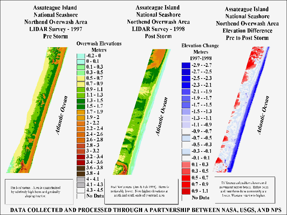
Coastal mapping at national seashores assesses vulnerability/impacts due to rising sea levels and global change, storm events, and man-made disturbances, i.e., construction of jetties and other structures. Scientists from the USGS Center for Coastal and Regional Marine Studies, St. Petersburg, Florida and NASA Goddard Space Flight Center implemented prototype projects at Biscayne National Park and the Florida Keys. They used NASA EAARL, a passive hyperspectral sensor and wave-form resolving laser system, to produce meter-scale coral reef ecosystem maps at a series of monitoring sites. With this new data and future repeat acquisitions it will be possible to monitor coral reefs, sediments, sea grasses and other underwater geologic and ecological processes and support scientific management of vegetation communities and wildlife habitat. Airborne Topographic Mapper Lidar surveys were collected at Atlantic coast national seashores in 2001 and 2002, with pacific coastal parks scheduled for 2002 and 2003. "Bald earth" digital elevation models and related mapping products from this system have been used at Assateague National Seashore for ten years and have provide extremely important information about barrier island dynamics. The system can measure vertical accuracy to 1 meter, providing a historical record of geomorphic changes caused by storms and the construction of jetties in Ocean City, Maryland, just to the north of Assateague. NPS and USGS staff will meet this June at Canaveral National Seashore to develop coastal mapping standards and related product specifications.
Fire burn perimeter and intensity mapping using a normalized burn ratio (NBR) technique developed by Carl Key (USGS office, Glacier National Park) and Nate Benson (Everglades National Park) compares pre-fire and post-fire Landsat scenes to generate a continuous index of burn severity. The terrain corrected Landsat scenes are collected on or near anniversary dates so that vegetation is in similar phenological states. NBR projects are being carried out through the USGS EROS Data Center at high priority fire parks in the continental U.S. and in Alaska. Burn severity products provide a landscape level understanding of the mosaic pattern of fire effects and burn scars. The data is valuable for fire team assessments, prescribed burn planning, updating fire fuel and vegetation layers, and fire behavior modeling and research.
FISH AND WILDLIFE SERVICE
The Fish and Wildlife Service (FWS) conducts Landsat based hydrologic mapping used to determine consumptive water use and in refuge negotiations and conducts annual airborne waterfowl surveys to determine productivity and state and flyway hunting allocations. A unique process combining video, GPS, aerial photography, and visual counts that are verbally recorded on audiotape are employed over 2 million square miles of waterfowl habitat in North America. FWS conservation and refuge managers, and partners such as Ducks Unlimited, rely heavily on this data source. The FWS aviation management branch in Albuquerque, New Mexico maintains specialized aircraft and expertise for aerial surveys, wildlife tracking, and remote sensing. Their aircraft includes the Partenavia Observer with a plexiglas nose that allows for unrestricted visibility and the Observer 2 with a large camera port/remote sensing platform. The aerial systems include an Accutrack imaging flight management system, Jana LMK 1000 large format camera with 9" x 9" negative size, video multimedia mapping systems, a high resolution 35 mm digital camera and a forward looking infrared thermal sensor.
THE OFFICE OF SURFACE MINING
RECLAMATION AND ENFORCEMENT
One of the largest DOI users of IKONOS imagery and data is the Office of Surface Mining Reclamation and Enforcement (OSMRE). OSMRE photogrammetrically processes IKONOS pan-sharpened multi-spectral stereo imagery and high accuracy GPS control points to model the terrain with 10-foot contours at surface coal mines. More expensive 2-foot contour terrain models have been developed by OSMRE from LIDAR and panchromatic photography. Orthophoto and topographic maps, terrain models, volumetric and other types of measurements are produced from these data to aid in monitoring and remotely inspecting mining compliance with federal regulations and coal mining permits and plans. Mines are required to mine within a permitted disturbance area, to comply with bonded road inspections, vegetation/re-vegetation standards, and engineering specifications for slope and elevation. The remotely sensed information and models, along with field verification data, can be used for regulatory enforcement as required under the Surface Mining and Control and Reclamation Act 1977. The bureau operates a terabyte image server at the Technical Information Processing System office in Denver for distribution to agencies and tribes involved with surface coal mining.
BUREAU OF RECLAMATION
The Bureau of Reclamation (BOR) was historically charged with "reclaiming" arid lands in the western U.S. for economic development. Today the BOR is well known for managing use and distribution of water and related construction of hydroelectric power plants, dams, and flood and irrigation systems. BOR is required to study environmental, human and economic impacts of water resource management and development projects and operations and requires sound baseline spatial data for planning, research and engineering services.
High Resolution digital elevation and hydraulic models produced from LIDAR continue to be used to map flood perimeters and depths below dams for predicting dam breach or spill events and resulting impacts. Crop inventory maps and consumptive water calculations are generated from Landsat TM, Indian Remote Sensing Satellite multispectral and panchromatic imagery, and USGS digital orthophoto quarterquads, for river basins of the Lahontan in Nevada and the Colorado River, and the Central Valley of California.
Remediation efforts to block mercury seepage into the Reclamation’s Owyhee Reservoir will be based on a cooperative remote sensing project between BOR and USGS. New maps of minerals and mercury sources in the Owyhee Basin of eastern Oregon are being produced using NASA Advanced Visible and Infrared Imaging Spectrometer (AVIRIS) hyperspectral data.
A multi-scaled change detection project in the Central Valley of California, used Landsat data from 1993 to 2000 to identify areas of change for subsequent aerial photography acquisition in 2001. By eliminating areas of no change from the Landsat image mapping phase and only re-mapping the change areas, BOR was able to substantially reduce project costs. Detailed maps of the change areas and image analysis will be used to comply with The California Central Valley Project Improvement Act Biological Opinion and in water-related negotiations with irrigation districts and the FWS.
MINERALS MANAGEMENT SERVICE
The Minerals Management Service (MMS) collects royalties for minerals extracted from Federal and Indian Lands, and oversees leasing and operations for mineral production (primarily oil and gas) on the Nation’s Outer Continental Shelf. These federal onshore and offshore mineral leases, located largely in the Gulf of Mexico, generate an average $4 to $6 billion in annual revenues, the government’s greatest source of non-tax revenue. The Mapping & Boundary Branch is a small nine-person office, centrally located in Denver, Colorado. This office deals full time with marine boundary and cadastre issues for MMS.
The Mapping and Boundary Branch, using GPS, historic maps and charts, and some remotely sensed coral reef maps, mapped and established federal ownership of delicate coral reef areas for NPS monuments in the Virgin Islands and Florida Keys. This office also delineated disputed legislative boundaries at Glacier Bay National Park, Alaska. With support from University of Colorado researchers, MMS conducted satellite altimetry studies for sea surface height and ocean currents in the Gulf of Mexico. The data derived from TOPEX/Poseidon and European RS-2 were processed and used in predictive oil spill models for offshore oil and gas operations.
BUREAU OF INDIAN AFFAIRS
GPS and remote sensing data are collected by the Bureau of Indian Affairs (BIA) for mapping and inventorying tribal land use, irrigation systems, dams, and natural resources, and developing environmental assessments. In addition, to standard orthophotos and other USGS cartographic products, the BIA uses IKONOS imagery as a base for flood zone modeling and as input to Emergency Action Plans.
CONCLUSION
The Department of the Interior is the Nation's principal conservation agency, responsible for managing 436 million acres, 66% of U.S. public lands or 19% of the U.S. land surface. Besides conservation, DOI is charged with providing safe recreation, meeting DOI trust commitments with Indian Tribes and Island Communities, and providing for environmental and physical science knowledge including hazard knowledge and warning. Each bureau's mission and goals are distinct but tied to these DOI goals. Remote sensing offers an efficient and economical method of mapping, inventorying, and monitoring public lands.
USGS is the lead bureau for coordinating and supporting the development and application of remote sensing technologies for DOI through the Landsat program, the Interior Geographic Data Committee, the Civilian Applications Committee and their earth science programs and research. The other DOI bureaus use remote sensing to provide geospatial data products and services in support of mapping, monitoring, mission and regulatory activities. Despite budgetary constraints, the challenge of commercial imagery licensing in the largely public domain environment of the federal data user community, lack of integrated data standards and image data management and distribution systems, the DOI is a leader in remote sensing use. The availability of new satellite, airborne, and software technologies and the increasing information needs of land managers ensure that DOI will increase the acquisition and use of remote sensing data and continue prototyping new systems and techniques in the future.