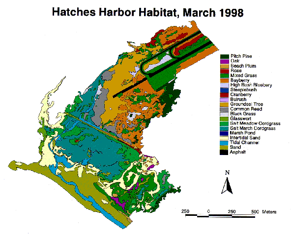
Click here see a detailed view of the Hatches Harbor habitat map.
Hatches Harbor: Restoring a Salt Marsh
By Norm Farris, CCNS
The Cape Cod National Seashore is in the middle of an exciting environmental restoration project. The Seashore is partnering with the Town of Provincetown to restore 90 acres of a 200 acre salt marsh adjacent to the Provincetown Municipal Airport (see Figure 1). The Hatches Harbor salt marsh is a remnant of a larger salt marsh complex that existed at the time of the first European settlement. This salt marsh was primarily a Spartina patens (salt hay grass) and S. alternifolia (smooth cord grass) community. In 1930, the upper 200 acres were enclosed behind a dike in an effort to control salt water mosquitoes. The elimination of tidal flow dewatered part of the upper marsh, changing the mosaic of salt marsh and wetland communities. Subsequently, a small airport was constructed on the landward end of the marsh, an airport was today is a vital part of the town's economy.

Figure 1. Hatches Harbor marsh, on the impacted side looking towards the airport
Today, the seaward end of the upper marsh inside the dike has a restricted tidal range that severely limits the extent of Spartina habitat. As a result Spartina (right hand side, Fig. 2) has been displaced by the invasion of Phragmites australis (left hand side, Fig. 2), the common reed into substantial parts of the old Spartina marsh. This Phragmites invasion has resulted in a degraded salt marsh community, with reduced nursery habitat, loss of shellfish habitat, and increased vulnerability to water quality deterioration. Salt marshes with unrestricted tidal flow have less troublesome mosquito populations because they provide habitat for fish that feed on larval mosquitoes.

Figure 2. Hatches Harbor Marsh from the dike top, restricted (left) and unrestricted (right)
Research conducted by National Park Service (NPS) and United States Geological Survey (USGS) scientists show that increasing the tidal range would greatly reduce Phragmites habitat, re-establishing Spartina habitat in its' place. This project has been designed to preserve the Provincetown Airport as it stands today as well as protect any future alternatives that may be proposed to enhance airport safety. The restored marsh would act as additional flood protection for the airport against big storms. The larger culverts to be installed during restoration would allow faster draining of standing water after heavy rainstorms.
The Seashore's plan is to replace the 2-foot wide culvert with four 7-foot by 3-foot culverts with adjustable tide gates. This will allow the culverts to slowly opened over a number of years and slowly replace Phragmites with Spartina habitat. A phased opening of the culverts will allow NPS scientists to monitor and control the restoration rate, preventing a sudden large die-off of vegetation. Such a quick die-off would create mud flats and open water that would attract large numbers of birds and thus pose a safety hazard to the airport. Five earthen berms will be constructed to protect the airport's instrument landing systems, as well as present and future airport operations. Completion of the restoration project would make it the largest salt marsh restoration project in Massachusetts.
The entire environmental permitting process has been a cooperative effort between the Seashore and the Town. A Memorandum of Understanding was signed to codify the organization and carrying out the restoration project. A NPS/Town Review committee that will review all aspects of the project will approve an operations plan (Figure 3). The goal of the permitting process is to broadly educate the public as well as all federal, state and local agencies, to the benefits of this project and again public support. The Seashore has met and will continue to meet with federal, state, local and Town agencies and committees to further describe construction and operation of the culverts, identify permitting requirements and address environmental and economic concerns.

Figure 3. Recent Restoration Site Assessment meeting attended by NPS, Town, Cape Cod Commission and Mass. DEM officials.
NPS, USGS and University of Rhode Island scientists are completing a season of biological, chemical and physical field sampling at Hatches Harbor. This sampling included vegetation sampling, bird and fish surveying, bivalve censusing and measurement of tidal exchange processes. This research is designed to establish a baseline to monitor the rate. It also gives valuable information to the Seashore and the Town that can be used to help determine the progress of the restoration and reveal any problems during the project. Scientists will be continuing their research at Hatches Harbor throughout the fall season, so if you see them working out there, don't hesitate to walk over and ask questions!

Figure 4. Hatches Harbor: Restoring a Salt Marsh