
|
|
|
OCIO Factsheets Interactive Map Center |
 |
|
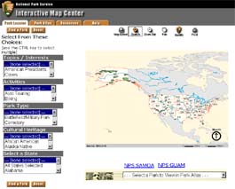
Park Locator The Park Locator enables users to search and query for parks on national and regional maps by type of park, activities, recreational interests, or geographic area. This application includes a collection of nationwide map layers that can be used to generate thematic maps of the national park system. The application includes a single map layer of national park boundaries along with an assortment of statistical attributes for each park. The user can select from any one of the available park layer attributes (e.g. Civil War) to see the park system symbolized by that attribute. The park layer can be overlayed on any of several different basemap layers (e.g. shaded relief, satellite imagery) that are available at various map scales. In addition, several reference layers (e.g. administrative boundaries, urban areas, highways, lakes and rivers) are available to turn on or off at different scales to customize the map view. Basic functionalities for the Park Locator application include zoom in, zoom out, zoom to full extent, pan map, identify features, and measure distances. The user can also use the identify function to click on a national park and view appropriate information about that park in a pop-up window and access a direct link to the web page (i.e. park profile) for that national park. Park Atlas The Park Atlas is an interactive online version of common park basemaps and reference layers. The atlas includes additional geographic content, such as natural resource and cultural resource map layers, depending on availability of data for individual parks. The current version only includes detailed data layers for two prototype parks: Yellowstone (YELL) and Gettysburg (GETT). Additional park atlases will be implemented over time as data and other resources become available. Future atlas options could include an intra-park planner that includes routing inside the park, trail routing, data delivery (Zip & Ship), as well as integration with other systems, e.g. the reservation system. Future IMS sites:
Other Related Sites:
Send Comments or questions to david_duran@nps.gov |
|
| ParkNet | US Department of the Interior | FOIA | Privacy Policy | Disclaimer | FirstGov |