| In February
of 1999, the satellite-based Global Maritime Distress Satellite System
(GMDSS) replaced the old SOS system. For a century, marine distress
calls were sent by the Radio Officer, in International Morse Code, on
the 500 KC frequency.
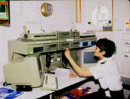
The GMDSS is a group of systems, controlled through a single console,
providing ships with communications, navigational information and
distress signaling. Three satellite networks provide long-distance
voice, telex, data, video and fax. Two services offer information
on weather, ice, and hazardous sea conditions. GMDSS also retains
direct medium and high-frequency radio capability.
GMDSS has an automatic distress system on the "INMARSAT C"
satellite network. A "Search and Rescue Transponder" deploys
manually or automatically if the ship sinks. With all its backups,
total failure of the GMDSS system is unlikely, but the complexity
of the system makes it prone to false emergency signals.
|
| The Emergency Position Indicating Radio
Beacon (EPIRB) is a small radio transmitter which sends an automatic
distress call via satellite to a land station, allowing rescuers to
locate the vessel or life raft at sea. This ACR Category I 406 MHz model
EPIRB is designed to float free and to automatically begin sending a
signal. It will work anywhere in the world.
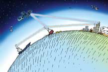
Above, GMDSS at work. A sinking ship can send a distress signal by
microwave satellite relay to a land station, by medium-frequency radio
to a nearby vessel, or by high-frequency radio to a shore station.
Illustration by Amy Hosa. |