- Glacier Research
This page summarizes some of the glacier research being done in Rocky Mountain National Park and some of the techniques commonly used to study glaciers. In addition to the words and images on this page, you can also access a series of interactive animations and graphics that allow you to "see" the techniques described below. These information modules are written in Adobe Flash so your web browser will need to have a Flash 7 or higher plug-in installed. Fortunately most computers and web browsers come with this player already installed. If your web browser doesn't read these files you can download a player free of charge at < http://www.adobe.com/products/flashplayer/
>.
Techniques for studying glacier change
Glaciers often appear static to the casual observer, but in fact they advance or retreat in dramatic ways compared to other geologic events. Various ways exist to measure glacial changes. One approach is to measure changes in their length and area. This has been a traditional method dating from at least the 1800’s and perhaps earlier. Other methods estimate changes in volume or mass. Also, the rate of glacier movement can be measured. The choice of which method or combination of methods depend on the question being asked, the resources available, and tools in hand. Because of their small size, sheltered locations, and complex interaction with debris cover, the glaciers in RMNP complicate traditional study techniques.
1) Mapping the terminus of glaciers
Perhaps the easiest approach to monitoring glacier
change is
to record the position of a glacier terminus. The distance to the ice
front from a fixed position is the most common method. With the advent
of global position system instruments, a locally fixed position may not
be required. Also, repeated photography, whether aerial, satellite, or
ground-based is another common method.
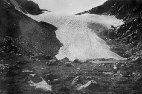
The National Park Service made annual measurements from fixed positions to the ice terminus for Andrews and Tyndall Glaciers from 1938-1955. However, these measurements were complicated by measuring to different locations year-to-year of an irregular terminus on Andrews Glacier. Tyndall Glacier’s terminus disappears under a mantle of debris before grading into a rock glacier, making it difficult to even clearly define a terminus. Furthermore, it became apparent after many years of measurements that the boulder used as a fixed point to measure from was not really fixed – because it was located on the rock glacier below Tyndall Glacier, it also was moving. Though these early measurements are not particularly useful, the early surveys also contained extensive photographs. Recently, researchers have used these photographs to reconstruct the fluctuations of glaciers at RMNP (1).
 |
| |
|
Figure 1 - Andrews Glacier 1916 (left photo - Willis Lee) and 2001 (right - John Achuff)
|
Additional information about field techniques used for measuring glacier termini
- Field techniques
- This module shows field methods used for measuring ice velocity, changes in glacier volume, and changes in terminus position.
|
|
|
2) Determining glacier characteristics using remote
imaging
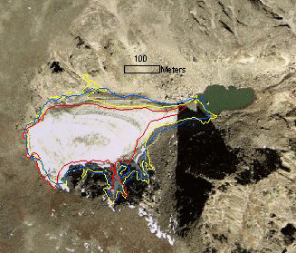
and digital mapping technology. Because of the difficulty and expense of traveling to and on glaciers, often glaciers are mapped using air photos and/or satellite images. Such images cover large areas of remote regions without the cost and time required for ground mapping (2). Furthermore, advances in digital processing technology have greatly reduced the time required to interpret the imagery and provided products that can rapidly be rescaled to meet a variety of needs. Combining these images with digitized historical maps yield a history of change in glacier length, area, debris cover, etc.
Because of small size of glaciers at RMNP, most satellite imagery does not have a high enough resolution to be of much use. However, aerial photography is very useful, provided it was taken at the end of the summer melt season but before the first fall snows (late August to early October). One problem in determining area change of small glaciers is that errors in the measurement of area may be large relative to the size of the glacier. Despite this, the use of remote imaging has been the most important technique for studying glacier change at RMNP (1).
 |
|
| Figure 2 - A 2001 aerial photograph of Andrews Glacier with outlines for 1946 (red), 1962 (yellow), and 1990 (blue). |
Additional information about remote sensing and GIS techniques used for mapping glaciers
- Remote sensing, mapping, and GIS
- This module shows how remote sensing and GIS (geographic information systems) are used to map and analyze glacier change. Click on the image on the right to access the module
|
|
|
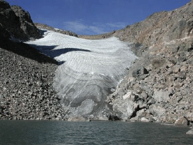
3) Determining glacier volume
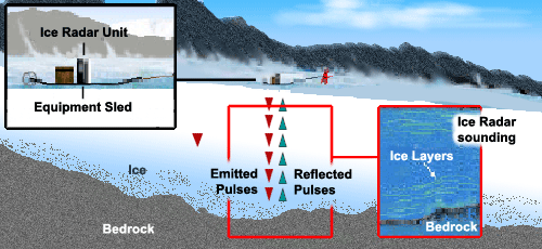
Glacier volume and volume change is important to climate change studies and to studies of alpine hydrology. Glaciers are frozen reservoirs of water that are released during the hottest and driest part of the summer. However, the remote location and size of many glaciers challenge attempts to accurately determine glacier volume. One method measures ice thickness using ice-penetrating radar, which is a portable radar transmitter / receiver that can be towed or carried across the glacier’s surface. As the unit travels over the surface, it emits a radar pulse that passes through the snow and ice until it reflected by various impurities in the ice or the base of a glacier back to the receiver. The ice thickness is calculated using the speed of the radar wave and total travel time to and from the unit. From the thickness map, the volume of the glacier can be calculated.
 |
|
| Figure 3 - Ice penetrating radar used for mapping the glacier bottom and ice thickness. The top inset shows the general structure of the unit, while the middle frame shows how it operates. The inset on the right shows an ice radar sounding, which is a vertical profile of the glacier. |
Ground surveys accurately measure glacier thickness and volume, they tend to be expensive and time-consuming. Furthermore, radar surveys are difficult in steep and crevassed glacier surfaces. Aerial surveys are possible, but they too are challenging on steep glaciers.
One alternative is to estimate glacier volume from surface area using a statistical relationship. While this method is imprecise compared to radar methods, it does provide a reasonable way to estimate glacier volume for many glaciers distributed over a broad region (3,4).
No thickness measurements have been made on glaciers in RMNP. However, ice-penetrating radar measurements have been taken on the nearby Arapaho Glacier, indicating a thickness of between 73 and 150 feet, and a reduction in thickness of 100 to 130 feet since 1960 (5). Within RMNP, numerous measurements of crevasse depth have been taken on glaciers, yielding a minimum thickness that can be used for volume calculations. Using this approach, it is estimated that RMNP contains about 6.7x10⁸ m3 of ice in glaciers and rock glaciers, approximately equal to twice the annual water use in the city of Denver (6).
Researchers
working
in Loch Vale estimate ice volume in that valley to be 2.1x10⁶ m3 for glaciers and 1.5x10⁶
to 3.0x10⁶ m3 for rock glaciers (7).
4) Monitoring glacier motion
Because glaciers move under their own weight, the speed of a glacier is related to its thickness and slope. Measuring glacier motion is often done by inserting stakes into the glacier ice and measuring their positions at different times. An early attempt to do this for Tyndall Glacier found that the stakes either melted out or were completely buried in snow before useful measurements could be taken (8). No glacier velocity measurements have been made since then. Velocity measurements on the Arikaree Glacier adjacent to Indian Peak Wilderness did not detect movement greater than 0.1 m/year, while the velocity of Arapaho Glacier has been measured at 3.7 - 2.4 m/year in 1960 and 1974 (9,10). The glaciers in RMNP are likely moving slower than Arapaho Glacier, and the presence of crevasses on Andrews, Tyndall, and Rowe glaciers suggest that they are not stagnant. The speed of rock glaciers in the southern part of the park have been measured at 13-20 cm/year (11). These speeds are slow, but not unusual for rock glaciers.
5) Measuring mass balance
Mass balance measurements quantify the mass changes of a glacier. This is the most direct measure between climate and glacier response. The climate usually determines the mass change of a glacier. Winter snow accumulation adds mass to the glacier and summer melt takes mass away. The volume of a glacier over a year’s time may be constant, yet the glacier gains mass in the accumulation zone and losses mass in the ablation zone. In equilibrium, the sum of mass gain and loss equals zero and the shape of the glacier does not change. Thus, annual volume change measurements do not track these seasonal changes. Seasonal changes are important because summer loss is the melt runoff to the alpine streams. Glacier advance and retreat result from long-term changes in mass, however a delay exists between mass change and glacier response imposed by slow glacier dynamics. Thus, mass balance measurements track the most direct and immediate response of a glacier to changes in the meteorological environment.
Mass balance was measured on Andrews Glacier from
1957-1964
(12). These measurements and photographs of the glacier show that in many years the entire glacier has a net of accumulation of snow and in other years the entire glacier loses mass. Because the glaciers in RMNP are so small and moving so slowly, they do not have an accumulation zone and ablation zone in the traditional sense.
Interestingly, mass balance measurements on Andrews Glacier correlate with average summer temperature (1,12). Due to the effects of wind redistribution of snow and the holding capacity of the cirque, winter accumulation on the glacier does not vary much, despite variations in total seasonal snowfall. Presumably the glaciers in RMNP are relatively insensitive to changes in winter precipitation and respond directly to summer temperatures and the amount of radiation they receive from the sun.
 |
|
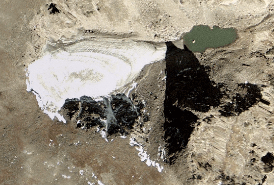
Figure 4 - Aerial photograph of Andrews Glacier. This photograph was taken in late summer near solar noon. Note how some of the glacier is shaded by local topography, protecting it from the sun.
|
6) Determining the extent of ancient glaciers using glacially-modified landscapes
As explained earlier, glaciers modify the landscape through erosion and deposition. After the ice has disappeared we can use this landscape to infer the former glacier position. For instance, when a glacier occupies a stream valley it deepens and widens the valley. When glaciers recede the valley cross-section is a characteristic U-shape. Likewise, as glaciers retreat they often leave behind with deposits of mixed rock and sand called moraines. The date of the moraines can sometimes be inferred from the age of trees or lichens growing on moraines.
While the existing glaciers in RMNP are all very small, the ice age glaciers left an impressive legacy, and the park is a very good place to see glacial landforms. The primary feature used in determining past glacier extent is mapping moraines. The timing of a glaciation can be determined by radiocarbon dating organic material (including muck and peat, charcoal, wood, buried soil, and lake sediments) found in or behind moraines. Ages can be extended to nearby moraines by correlating morphology (shape and structure), weathering (degree of preservation or erosion), and soil development. Major advances occurred from 29 to 8 thousand years ago, around 100 thousand years ago, and at some times earlier (13). At these times valley glaciers extended between 1 and 45 km down-valley from their sources, and a small icecap formed at the headwaters of the Cache la Poudre River (13).
Time line of glacier research in Rocky Mountain National Park
- 1873-1878: F.M. Endlich, J.J. Stevenson, F.V.
Hayden, A.R.
Marvine, C. King, and others publish descriptions of glacial landforms
in various parts of Colorado, but no mention of actual glaciers (14).
- 1887: G.S. Stone makes the first scientific
description of a
glacier in Colorado when he describes Hallett Glacier (now known as
Rowe Glacier) in northern Rocky Mountain National Park in the journal Science (15).
- 1905:
Enos Mills (considered the Father of Rocky Mountain National Park)
writes a guidebook that includes a map locating Andrews, Hallett (now
Rowe), Sprague, and Tyndall glaciers (16).
- 1910:
Junius Henderson publishes descriptions of Andrews, Hallett (now Rowe),
Sprague and Tyndall glaciers, as well as the extent of Pleistocene
glaciation in Colorado (14).
- 1915: Rocky Mountain National Park established.
- 1917: W.T. Lee describes two major advances of Pleistocene glaciers in RMNP (17).
- 1934-1955: RMNP personnel perform annual
glacier
monitoring of Andrews and Tyndall Glaciers. Their work
includes
photography of both glaciers from numerous vantage points and
measurements from fixed points to the glacier termini.
- 1934-1944: Wellington Jones and Louis Quam extensively map Pleistocene glacier landforms east of the Continental Divide in RMNP. The independently reach similar conclusions about the extent and timing of glaciation and publish their findings together (18).
- 1940: Ronald Ives describes rock glaciers in the Front Range, including one in Hitchens Gulch and Hague Creek Valley in RMNP (19).
- 1953:
Investigation of additional deposits leads Ives to believe that
northern Rocky Mountain National Park was covered by a small ice cap
during the Pleistocene (20).
- 1957-1963:
RMNP personnel survey a longitudinal traverse down the center of
Andrews Glacier that provides seven years of valuable mass balance data
(12).
- 1960:
Charles C. Morrison includes Andrews and Tyndall glaciers in the first
systematic photo survey of glaciers of the Rocky Mountains (21).
- 1950-1960:
Gerald M. Richmond refines the glacial geology of RMNP, identifying
three major Pleistocene glaciations and two minor advances during the
Holocene (22).
- 1962-1965: Samuel Outcalt and Donald MacPhail from the University of Colorado conduct detailed photogrammetric studies of most glaciers in the Front Range (including Andrews, Moomaw, and Tyndall in RMNP). By comparing aerial photos taken in late spring and late summer they are able to determine the change in volume each season for two years at each glacier. They also note the significance of rock glaciers in the region (12).
- 1961-1971: Sidney White performs a detailed study of the movement and age of Taylor rock glacier (23).
- 1970s-1980s: Richard Madole and James Benedict further develop glacial history of the Front Range, identifying up to five Holocene advances by using radiocarbon dating, including many sites in RMNP (24, 25, 26, 27).
- 1987: Eric Rainey and others study the recession of the valley glacier in Horseshoe Park since the Last Glacial Maximum (28).
- 1990:
Margaret Marker analyzes the locations of former periglacial landforms
in Colorado, including in Rocky Mountain National Park (29).
- 1990s: R.B. Scott continues photography of glaciers
started
by the Park Service in the 1930s-1950s.
- 1990-2003: David Clow and others study groundwater in Loch Vale. They identify ice stored in permafrost (including rock glaciers) to be the second largest reservoir of water in the valley (7).
- 1995-Present: Jon Achuff maps glaciers, ice patches, and rock glaciers across the park. He also reinstates annual photography of Andrews and Tyndall glaciers (6).
- 2000-2005: Jason Janke maps rock glaciers across the Front Range and measures movement of rock glaciers in the southern part of RMNP over twenty years (11,30).
- 2005:
Matthew Hoffman and others determine the change in RMNP glaciers during
the twentieth century and find a similar pattern to other areas of the
western US, but with less dramatic retreat (1).
- Hoffman, M.J., Fountain, A.G., Achuff, J.M. 2007. Twentieth-century variations in area of small glaciers and icefields, Rocky Mountain National Park, Rocky Mountains, Colorado, USA. Annals of Glaciology.
- Fountain, A.G., Krimmel., R.M., and Trabant, D.C., 1997, A Strategy for Monitoring Glaciers, Circular 1132, U.S. Geological Survey, 19 p.
- Bahr, D., Meier, M., and Peckman, S., 1997, The physical basis of glacier volume area scaling, Journal of Geophysical Research, vol. 102, B9, p. 20,355-20,362.
- Chen, J. and Ohmura, A., 1990, Estimation of alpine glacier water resources and their change since the 1870s, Hydrology in mountainous regions - I. Hydrologic measurements, the water cycle. Proceedings of the two Lausanne Symposia, IAHS Publ. no. 193, p. 127-135.
- http://www.rockymountainnews.com/drmn/local/article/0,1299,DRMN_15_3281315,00.html
- Achuff, J.M. 2003. Estimated water storage within glacier complexes in Rocky Mountain National Park. Abstracts with Programs - Geological Society of America. vol. 35, no. 6, p. 132.
- Clow, D.W., Schrott, L., Webb, R., Campbell, D.H., Torizzo, A., Dornblaser, M. 2003. Ground water occurrence and contributions to streamflow in an alpine catchment, Colorado Front Range. Ground Water. vol. 41, no. 7, p. 937-950.
- Chapin, F.H. 1893. Mountaineering in Colorado. W.B. Clarke & Co., Boston, pp. 69-96.
- Waldrop, H.A. 1964. Arapaho Glacier: a sixty-year record. University of Colorado Studies, Series in Geology. No. 3., 37 pp.Â
- Johnson, J.B. 1979. "Mass balance and aspects of the glacier environment, Front Range, Colorado, 1969-1973." (Ph.D. Dissertation, University of Colorado), 285 pp.
- Janke, J.R. 2005. Photogrammetric analysis of Front Range rock glacier flow rates. Geografiska Annaler. vol. 87A, no. 4, p. 515-526.
- Outcalt, S.L. and MacPhail, D.D. 1965. A Survey of neoglaciation in the Front Range of Colorado. University of Colorado Studies Series in Earth Science, No 4. Univ. of Colorado Press, Boulder, Colorado.
- Madole, R.F. 1976. Glacial geology of the Front Range, Colorado. in Mahaney, W.C. (ed.) Quaternary Stratigraphy of North America, Stroudsburg, Pa.: Dowden, Hutchinson & Ross.
- Henderson, J. 1910. Extinct and existing glaciers of Colorado. University of Colorado Studies, Volume 8, Number 1, Boulder, CO.
- Stone, G.H. 1887. A living glacier on Hague's Peak, Colorado. Science, vol. 10, p. 153-154.
- Mills, E.A. 1905. The story of Estes Park and a guide book. Outdoor Life Publishing Company, Denver, CO.
- Lee, W.T. 1917. The geologic story of the Rocky Mountain National Park, Colorado. U.S. National Park Service, 89p.
- Jones, W.D. and Quam, L.O. 1944. Glacial land forms in Rocky Mountain National Park, Colorado. Journal of Geology, vol. 52, no. 4, p. 217-234.
- Ives, R.L. 1940. Rock glaciers in the Colorado Front Range. Bulletin of the Geological Society of America, vol. 51, p. 1271-1294.
- Ives, R.L. 1953. Anomalous glacial deposits in the Colorado Front Range area, Colorado. Transactions, American Geophysical Union, vol. 34, no. 2, p. 220-226.
- Morrison, C.C., Jr. 1960. Glacier reconnaissance, American Rocky Mountains, 1960. Association of American Geographers.
- Richmond, G.M. Glaciation of the east slope of Rocky Mountain National Park, Colorado. Bulletin of the Geological Society of America, 71, 1371-1382
- White, S.E. 1971. Rock glacier studies in the Colorado Front Range, 1961-1968. Arctic and Alpine Research, 3, 1, 43-64.
- Benedict, J.B. 1973. Chronology of cirque glaciation, Colorado Front Range. Quaternary Research, 3, 584-599.
- Madole, R.F. 1976. Glacial geology of the Front Range, Colorado. in Mahaney, W.C. (ed.) Quaternary Stratigraphy of North America, Stroudsburg, Pa.: Dowden, Hutchinson & Ross.
- Madole, R.F. 1976. Bog stratigraphy, radiocarbon dates, and Pinedale to Holocene glacial history in the Front Range, Colorado. Journal of Research, U.S. Geological Survey, 4, 2, 163-169.
- Madole, R.F. 1980. Time of Pinedale deglaciation in north-central Colorado: Further considerations. Geology. 8, 118-122.
- Rainey, E.M., Hoyt, W.H., Hopkins, K.D. 1987. Sedimentary record of Pinedale ice recession in Horseshoe Park, Rocky Mountain National Park, Colorado. Abstracts with Programs - Geological Society of America. 19,5, 327.
- Marker, M.E. 1990. Minimum altitudes for former periglacial landforms adjacent to longitude 106 degrees W in Colorado and New Mexico, USA, between latitudes 33 degrees N and 40 degrees N. Arctic and Alpine Research. 22, 4, 366-374.
- Janke, J.R. 2005. The occurrence of alpine permafrost in the Front Range of Colorado. Geomorphology. 67, 3-4, 375-389.
|