
Besides using roads for travel, armies in the Revolutionary War often fought on them. The Americans and the British fought the Battle of Cowpens along a road known today as the Green River or Mills Gap Road. The Green River Road ran from the Pacolet River in South Carolina to the Green River and into western North Carolina. The history of the Green River Road encompasses more than the Battle of Cowpens. In order to avoid boggy wetlands, settlers and Native Americans created the road by using the highest points between watersheds as a wagon and market trail prior to the American Revolution. On October 6, 1780, Cowpens was used as a gathering place for the men who fought the Battle of Kings Mountain the following day. Thus, it is also one of the original segments of the Overmountain Victory National Historic Trail, traveled by militia in pursuit of British commander, Patrick Ferguson at Kings Mountain. Those who traveled west on the Green River Road from the Pacolet River crossed various creeks, including Thicketty Creek. West of what is now Cowpens National Battlefield the road led into North Carolina and eventually crossed the Green River (now in Polk County), a tributary of the Broad River. The road continued the steep climb through Mills Gap on the boundary between present-day Polk and Henderson counties, giving it the alternate name, Mills Gap Road. With its connection to the Buncombe Turnpike from Tennessee, the Green River Road helped connect the backcountry to a larger network of early American wagon and market roads. Battle of CowpensBoth armies arrived from the southeast on this road. The Patriot army under Daniel Morgan arrived on January 16, 1781, camped alongside the road, and prepared to make a stand. British forces under Banastre Tarleton began marching at 3:00 a.m. on January 17, and launched an attack at daybreak. Both armies deployed along the Green River Road. The Green River Road figured prominently, also, at the end of the battle. On a portion of the Green River Road, Patriot cavalry leader William Washington fought hand to hand with a British officer and, according to legend, was saved only by the quick actions of his servant. Refusing to be taken prisoner, Tarleton and over 50 of his horsemen escaped east on the road and onto a connecting road to Hamilton’s Ford on the Broad River. Following the battle, Daniel Morgan moved with his army and prisoners west on the Green River Road, soon turning north on the Island Ford Road to enter North Carolina. The Road TodayThe Green River Road, known as the Mills Gap Road or by its connecting roads according to the destination of the traveler, changed as the region changed. The rise in importance of other roads that were a more direct route to Spartanburg possibly led to the decline of the Green River-Mills Gap Road. The road was changed and straightened over the years, but portions of the original road, now paved for automobile traffic, remain in both North and South Carolina. Perhaps, more than anything, the Green River Road connects us to the history of this area. 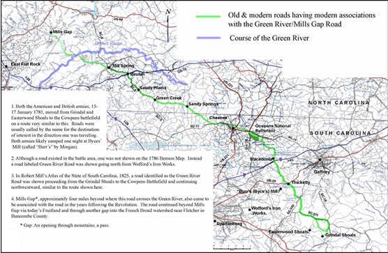
John Robertson |
Last updated: April 14, 2015