
UNITED STATES PLATT NATIONAL PARK Platt National Park in Southern Oklahoma shares with Hot Springs National Park in Arkansas the distinction of having been set aside because of the mineral properties of the waters. They were reserved by the national government to make the waters available without exploitation to all classes of visitors. Though many persons go to Platt to drink its healing waters, others are drawn by its recreational and scenic attractions. The park is adjacent to the town of Sulphur, and extends in irregular form for a distance of approximately three miles from northeast to southwest along Travertine and Rock Creeks. The elevation varies from 920 to 1150 feet. The gently rolling area of the park offers a pleasing relief from the comparatively level surrounding country. Most of the area is well wooded and traversed by picturesque streams with a number of springs, small waterfalls, and cascades. Travertine Creek, which flows through most of the Eastern end of the park, is a beautiful stream of clear sparkling water, fed by numerous springs. Rock Creek enters the park from the north, just below the principal entrance from the town of Sulphur, and Travertine Creek empties into it. To the south of Rock Creek is "Bromide Hill", a steep wooded bluff 140 feet high. From the summit, known locally as "Robbers' Roost", easily reached by trail or road, there is a splendid view to the north and east, over the whole park and the town of Sulphur. Far in the distance to the southwest can be seen the picturesque Arbuckle Mountains and the Washita River Valley. The principal mineral springs of the park issue from the base of this hill. 
SPRINGS LONG USED It is not definitely known when the spring waters were first used for curative purposes. Tradition has it that the waters were known to the Indians, and that for many decades before the coming of the white man, the creek banks were dotted with the tepees of the Indians who came to drink the waters at certain seasons of the year. It is further recorded that white men first learned of the springs from the Indians. The summit of Bromide Hill was known to them as "Council Rock" and from there signal fires flashed messages to distant points. Whether these legends are true or not, the area now included in the park was for years, and still continues to be, a favorite camping ground and meeting place for the Indians. The abundance of water in a comparatively arid area also attracted numbers of wild animals, and gave the region a reputation as a hunting ground. Traces of this linger in the naming of the principal springs after the antelope and buffalo. No one knows definitely who was the first white man to view the region, but it is regarded as fairly certain that Thomas Nuttal, the famous botanist, was there in 1819 on his memorable trip from Fort Smith, Arkansas. Platt National Park is located within the holdings of the Choctaw Nation of the old Indian Territory, established in 1832, and the greater part of the area was purchased from the Indians when the Sulphur Springs Reservation was established in 1902. On June 29, 1906, the name was changed to Platt National Park in honor of Orville Hitchcock Platt, Senator from Connecticut for 26 years, who was distinguished for his service to the red man as a member of the Committee on Indian Affairs. Much of the park area is characterized by conglomerate rock which outcrops frequently. Along Travertine Creek there are interesting deposits of travertine rock, a variety of soft limestone forming weird and fantastic shapes with comparative rapidity. Frequently, it almost encases living roots, stones, or other objects. PRINCIPAL SPRINGS There are thirty-two springs of major importance and several, minor ones. Eighteen may be broadly classed as sulphur, six as fresh water, four as iron, and three as bromide springs. The waters of the springs are for the equable use of all visitors, but they should be taken extensively only on the advice of competent physicians. The National Park Service facilitates the usefulness of the springs only by protecting and maintaining them according to the best possible standards. There are no provisions in the park or at the town of Sulphur for free consultation of physicians or treatment of the sick. Pavilion Springs, Sulphur Bromide Spring, and Medicine Spring are among the best known of the mineral waters of the park. The best known of the Pavilion group is "Big Tom." These springs are located on Highway No. 18 across from Travertine Creek, near the former location of the old town of Sulphur. The Sulphur Bromide Spring issues from the base of Bromide Cliff and is dispensed from the Bromide Pavilion. Medicine Spring is also located here and dispensed from the pavilion. The waters of Black Sulphur Spring are strongly impregnated with sulphur. This spring is located directly across Rock Creek from Flower Park and is dispensed from a small pavilion. Hillside Springs issue from a grotto in a rock wall just below the park office. This water is also sulphur, and flows about eighty gallons per minute. NATURAL SPRINGS In the eastern end of the park along Travertine Creek are two natural springs of considerable volume, flowing over 5,000,000 gallons per day of pure natural water. It is said that these were named from the herds of antelope and buffalo from the surrounding prairies which formerly came there to drink. Buffalo Springs boils through a bed of sand in a most interesting manner. An extensive development of the adjacent area has been undertaken by the National Park Service, so that it now includes a natural stone basin for the spring, a barbecue pit, and ample parking space and picnic grounds. Buffalo Springs marks the eastern end of the park and the terminus of the trail and road system. Antelope Springs, a short distance away, bursts from a group of conglomerate rocks in the hillside. This spring flows at the rate of 2000 gallons per minute, and is probably the most popular spring in the park. Nearby picnic grounds and a parking space have been developed. ANIMALS AND PLANTS Visitors to Platt National Park have an opportunity to see bison and elk, and occasionally deer. The raccoon, opossum, skunk, and cottontail rabbit are common. Jack and swamp rabbits are seen occasionally, and once in a while a muskrat. Fox squirrels scurry about the camp grounds making new friends every day. Bird lovers will find many feathered favorites in the park at all seasons. The western meadow lark, prairie horned lark, sparrow hawk, and dove are to be seen in the open areas, and in the woodland are the robin, cardinal, orchard oriole, brown thrasher, yellow-bellied fly catcher, and many others. Along the streams are the kingfisher, winter wren, and little green heron. The plant life of the park is varied and interesting because this section of the country is a meeting place of various plant groups. In addition to the familiar eastern and northern hardwoods there are many distinctly southern trees and desert plants, including yucca. The most noteworthy flowering trees are the redbud, white flowering dogwood, Chickasaw plum, first to bloom in the spring, and various hawthorns. The rarest tree in the park is the Indian Cherry. The most common of the vines is the Virginia creeper, notable for its brilliant scarlet coloring in autumn. Woolly Dutchman's Pipe with its curious flowers, wild frost or opossum grape, popular because of its fragrant flowers, and bittersweet flaunting bright colored berries in winter also contribute materially to the beauty of the park. The handsome standing cypress or the Spanish larkspur, blooming in midsummer, is the most spectacular wild flower Other favorites are the primrose, lovely purple Kansas gay-feather, blue salvia, showy cardinal flower, goldenrod, and the asters. The prairie lily springs through the turf on the golf course after heavy rains. This curious plant is also called the rain lily. Prickley pear, ball cactus, and green-flowered hedge hog cactus, each an interesting desert plant, are fairly common on the upper levels of the park. Another interesting plant is the sensitive brier or cat's claw, an unusually handsome pink sensitive plant. It is also known as gander's teeth. 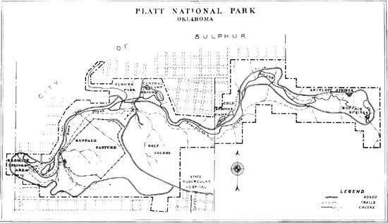
RECREATIONAL FACILITIES Platt Park has been developed for the fullest enjoyment of its visitors. A carefully planned trail leads from the summit of Bromide Hill to Buffalo Springs, a distance of nearly four miles. From the main entrance to "Robbers' Roost" on Bromide Hill is 1/2 mile and from the same place to Buffalo Springs is 3 miles. Another trail known as the "Cliffside Trail" leads from about half way up Bromide Hill to Black Sulphur Springs No. 2 and the Perimeter Boulevard. These trails are carefully laid out to avoid the brilliant sunlight as much as possible, and the grades are easy. The trails are suitable for horseback riding from Pavilion Springs to the intersection of "Cliffside Trail" and along that trail to Black Sulphur Springs No, 2, and also from Pavilion Springs to Buffalo Springs. Usually the park superintendent or the local hotel managers can arrange for hiring saddle horses. Within the park there is a complete circuit drive eight miles in length. This road has been designed according to park standards, to give as comprehensive and scenic view of the park as possible; and offers a pleasing variety of scenery. FISHING The streams of the park are well stocked with fish. In Travertine Creek there are rainbow trout, and croppie, blue gill, and perch are plentiful in Rock Creek. PUBLIC CAMP GROUNDS Free camp grounds with water, lights, and sanitary facilities are maintained at three places within the park: Cold Springs, Central Camp Grounds, and Bromide Springs. The latter area was established primarily for the benefit of people coming to the park to drink the waters. PICNIC AREAS There are a number of attractive picnic sites in the park, most of which are equipped with tables, fireplaces, and water. A picnic area accommodating large parties has been constructed at Travertine Island. GOLF AND TENNIS A nine-hole golf course has been developed within the park and is administered by the Platt National Park Golf Club. There is also a double tennis court with asphalt surface. SWIMMING Swimming and wading are allowed along Travertine Creek. There are several swimming pools, with bath houses and showers in the town of Sulphur. FISHING Fishing with hook and line is permitted in Rock Creek. Travertine Creek is stocked with trout, but is open for only a few days per year, at the discretion of the superintendent. THE TOWN OF SULPHUR The town of Sulphur is immediately adjacent to the park and forms practically the entire northern boundary. Sulphur has a population of more than 4,000, and is governed under the laws of Oklahoma and by city ordinances. The National Park Service exercises no control over any matters connected with the town. Sulphur is divided centrally by Rock Creek into East Sulphur and West Sulphur. The town has its own water supply system, and in addition is furnished with all of the public utility services of modern cities. There are churches of every denomination, excellent city and state schools, hospitals and sanitariums, bath houses, theaters, swimming and amusement places, a convention hall, and good hotels, restaurants, and tourist cabins. ADMINISTRATION Platt National Park is maintained by the National Park Service of the Department of the Interior. The superintendent is William E. Branch, and general information may be secured from him at the park office. Although the principal season for visitors is during the summer months, Platt National Park is open throughout the year. Because of the streams and abundant shade, the park area is noticeably cooler than the surrounding country in summer. The fall and spring months are delightful, and the winters are usually mild and open. 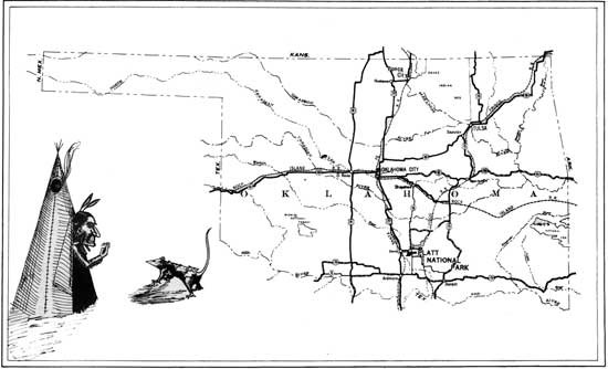
(click on image for a PDF version) HOW TO REACH THE PARK Platt National Park is located in Southern Oklahoma, approximately midway between Oklahoma City and Dallas, Texas. It is 300 miles west of Hot Springs National Park, Arkansas, and 600 miles east of Carlsbad Caverns National Park, New Mexico. It is easily reached by splendid highways shown on the map of Oklahoma in this booklet. Connection with major bus lines both north and south may be made at Davis, while service to Ada on the east and Durant to the southeast is maintained from Sulphur. An airport is now being constructed at Sulphur, and will offer service to Dallas and Tulsa. Railway service is maintained by the Santa Fe Railway at Davis, with direct service north to Oklahoma City, Kansas City, and Chicago, and direct connections at Newton, Kansas, for Denver, Colorado, and Pacific coast points. From Davis south there is direct service to Dallas and Fort Worth, with interchange service to Houston, Galveston and south Texas points. At Scullin on the east connections are made with the Frisco Lines for Tulsa and Saint Louis to the north and east, and to Dallas on the south. NEARBY POINTS OF INTEREST There are a number of interesting points near the park which visitors may wish to see. Turner Falls State Park is a lovely area in the heart of the scenic Arbuckle Mountains. The falls are a beautiful spectacle, and the entire region is one of rich geologic interest, particularly structural geology and paleozoic fossils. Prices Falls is also located in the heart of the Arbuckles, and consists of numerous falls in a beautiful mountain stream. Shell Mound is an interesting heap of fossil shells found near Dougherty. Mystic Cave, never completely excavated or explored, is located twelve miles south of Sulphur. A subterranean stream flows along a tortuous passage, and there are abundant stalactite and stalagmite formations of considerable beauty. Fish and crawfish found here are blind and of albino coloring. The Devil's Den, near Tishomingo, twenty-six miles away, is a grotesque formation of huge granite boulders, of considerable interest and beauty. Rules and Regulations The park regulations are designed for the protection of the natural beauties as well as for the comfort and convenience of visitors. The following synopsis is for the general guidance of visitors, who are requested to assist in the administration of the park by observing the rules. The complete regulations may be seen at the office of the superintendent of the park. The destruction, injury, defacement or disturbance of any buildings, signs, equipment, rocks and minerals, or flora and fauna of the park is prohibited. No camping shall be permitted upon any land not specifically designated for that purpose by the superintendent. Camps may not be maintained in the park for a period longer than 30 days without permission in writing from the superintendent. Camps must be kept clean. Rubbish and garbage should be burned on camp fires. Other refuse should be placed in receptacles provided for that purpose. Fires shall be lighted only when necessary and when no longer needed shall be completely extinguished. No lighted cigarette, cigar, match or other burning material shall be thrown away unless completely extinguished. The hunting, killing, wounding, frightening, capturing, or attempting to capture any wild bird or animal is prohibited. Fishing except with hook and line is prohibited. The limit for a day's catch per person is 15 fish. Fishing in any of the waters of the park may be prohibited by order of the superintendent. Between the hours of 8:30 p.m. and 7:00 a.m. from October 1 to April 30, inclusive, and between the hours of 11:00 p.m. and 7:00 a.m. from May 1 to September 30, inclusive, the park is open only to campers and persons traveling through and upon the roads. Loitering in the park is prohibited. Gambling in any form is prohibited. Drive carefully at all times. The penalty for violation of the rules and regulations is a fine not exceeding $500, or imprisonment not exceeding six months, or both, together with the costs of the proceedings. THE GOVERNMENT IS NOT RESPONSIBLE FOR ACCIDENTS OF ANY NATURE. |
Last updated: February 24, 2015