Hoodoos

Hoodoos at dawn
Hoodoos in the very early morning.

Brian Roanhorse/NPS

 
Map of Lake Claron across Utah 50 million years ago
Lake Claron existed around 50 Million Years ago, and was the source for the colorful rocks of Bryce Canyon

Wikipedia

The Three-Step Recipe to Create Bryce Canyon

The formation of Bryce Canyon and its hoodoos requires 3 steps:
1) Deposition of Rocks
2) Uplift of the Land
3) Weathering and Erosion

1. Deposition of Rocks: Born in a Lake/Floodplain System
The first step to create Bryce Canyon’s hoodoos involves the deposition of flat lying rocks. Bryce Canyon’s rocks reveal stories of an ancient lake and floodplain system, which first appeared around 50 million years ago. This low lying area was surrounded by areas of higher topography to the west, which encouraged streams to strip particles from these highlands and deposit them into the low lying basin area. These tiny particles accumulated and cemented together to create Bryce Canyon’s rocks (limestones, dolostones, mudstones, siltstones and sandstones).
Bryce Canyon’s rocks formed near sea level. After a quick glance at any of our maps and you will realize that we are now well above sea level - Bryce Canyon sits at a maximum elevation of 9,115 ft (2,778 meters) above sea level. How did such large bodies of rock appear to travel such a tremendous distance in elevation? In order to understand how such a dynamic event has occurred, continue to read the next section and see how Plate Tectonics has played its role in Bryce Canyon’s formation.

 
Diagram showing oceanic plate sliding underneath North America, causing heat to rise
Heat generated by the descending Farallon Plate led to uplift of the Colorado Plateau

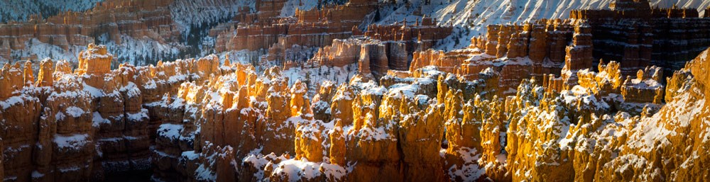
2. Uplift of the Land: Plate Tectonics Creates an Uplifting Experience
Plate Tectonics can be thought of as the giant puzzle pieces that collectively create the surface of our entire planet. The Earth’s plates are in constant motion. Sometimes these massive pieces of Earth crash into one another, and that is exactly what happened here. The North American plate and the Farallon plate came into head on collision! As a result, the Farallon Plate was forced underneath the North American Plate. This process is known as subduction.
The relatively shallow subduction of the Farallon plate resulted in some elevation of the overlying North American plate; however, this region’s rise to its current altitude mostly occurred in the last several million years as the Farallon plate began to break apart allowing heat to rise and elevate the modern "Four Corners" area known as the Colorado Plateau.
Plate tectonic interactions have uplifted Bryce’s rocks to the “goldilocks zone” - the perfect elevation for the forces of nature to create Bryce’s hoodoos. It is at this elevation in which the forces of nature can break down Bryce’s rocks to create its current landscape.


3. Weathering and Erosion: The Sculpting of Hoodoos

Weathering is the breaking down of rock and erosion is the transportation of that broken rock. These two forces of nature work in concert to sculpt Bryce Canyon’s hoodoos. The main natural forces of weathering and erosion that create the Hoodoos are ice and rain.
The elevation in which Bryce Canyon is located receives both above freezing temperatures and below freezing temperatures over 170 nights out of the year. That is more than half of the days of the year in which Bryce Canyon reaches above/below freezing temperatures in the same night! This is crucial to creating the Hoodoos.
When water (from either rain or snow that has melted) seeps its way into the cracks in the rock, it resides there. Hours later, when Bryce Canyon is met with freezing temperatures, the water trapped inside the rock begins to freeze into ice. When water freezes into ice, it expands by 9%! This expansion into ice causes tremendous pressure on the surrounding rock, and thus causes it to break apart. This process is known as “ice wedging”, because the ice is literally wedging apart the rocks.
From a plateau, eventually the rocks break down into walls, windows, and then as individual hoodoos.

 
Sequence showing the show erosion of a hoodoo, from plateau to rock spire
From a plateau, eventually the rocks break down into walls, windows, and then as individual hoodoos.

Brian Roanhorse/NPS

Part of the beauty of the hoodoos comes from their strange patterns. The shape of the hoodoos is attributed to slight variances in the material which comprises the rock. If you recall from the “deposition” section above, there are multiple types of rocks that make up Bryce Canyon. All of the rocks contain abundant calcium carbonate (CaCO3), a mineral that dissolves when it comes into contact with even slightly acidic water. When it rains at Bryce Canyon, the (slightly) acidic rain is enough to dissolve the calcium carbonate that holds these rocks together and allows them to erode into their current shape (and continues to shape them).

When you look at the Hoodoos you will notice some layers that jut out, and some that indent inwards. This is a result of the rocks having varying amounts of calcium carbonate cementation and that controls how easily dissolvable (or how resistant) that rock layer is.
 

Further Reading:
DeCourten, Frank. 1994. Shadows of Time, the Geology of Bryce Canyon National Park. Bryce Canyon Natural History Association.

Kiver, Eugene P., Harris, David V. 1999. Geology of U.S. Parklands 5th ed. John Wiley & Sons, Inc. 522-528.

Sprinkel, Douglas A., Chidsey, Thomas C. Jr., Anderson, Paul B. 2000. Geology of Utah's Parks and Monuments. Publishers Press: 37-59

(top of page)

Last updated: September 4, 2021

Park footer

Contact Info

Mailing Address:

P.O Box 640201
Bryce, UT 84764

Phone:

435 834-5322
Phones are answered and messages returned as soon as possible as staffing allows.

Contact Us